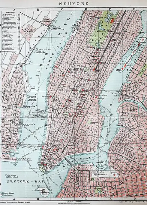
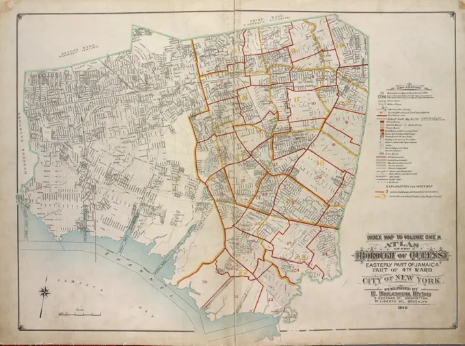
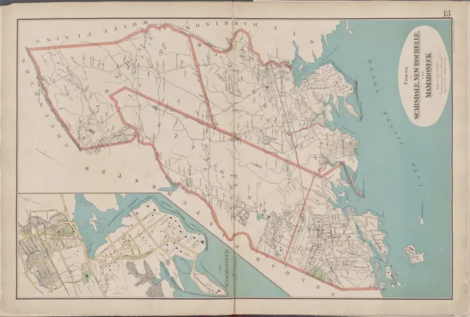
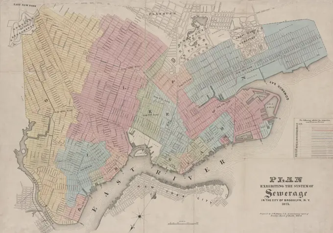
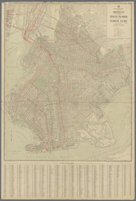
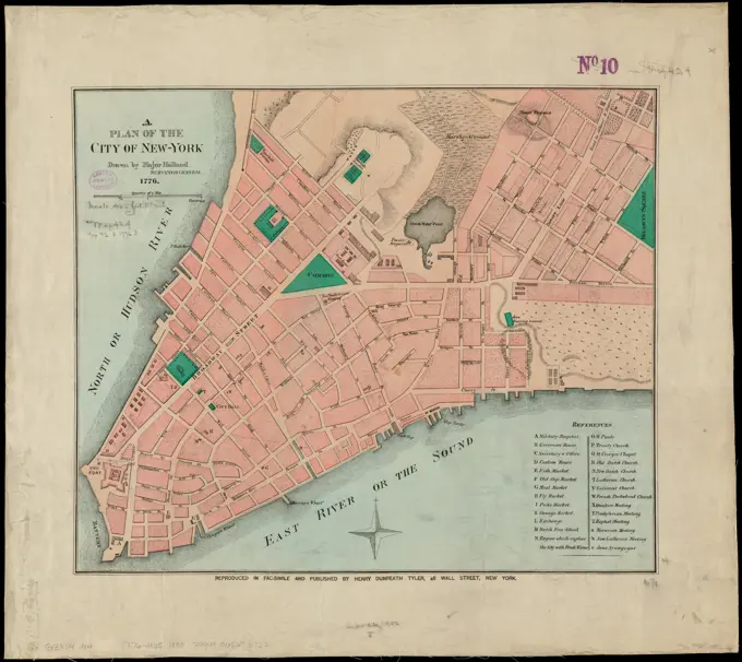
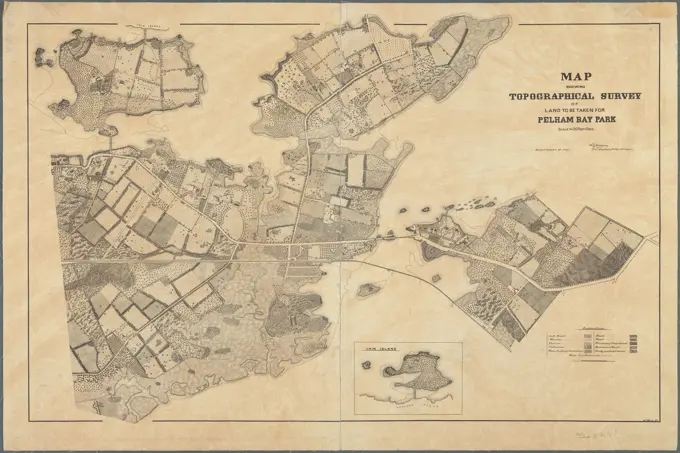
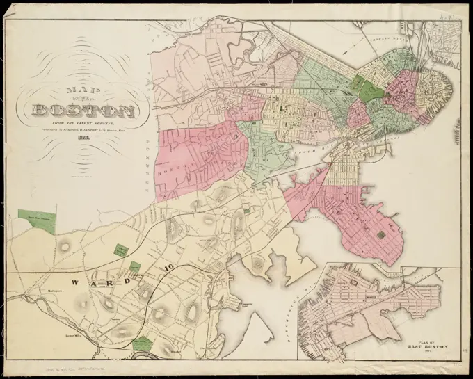
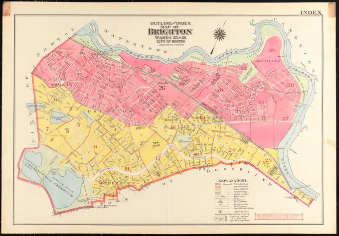
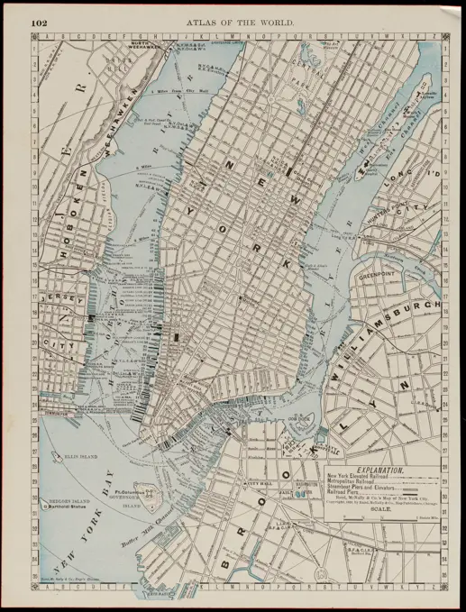
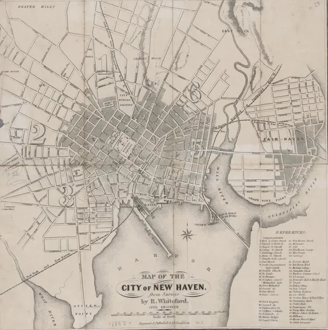
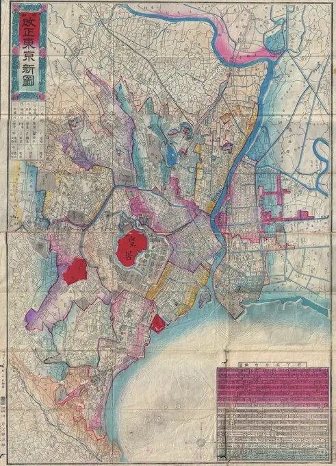
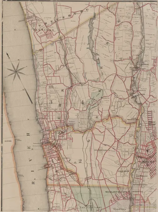
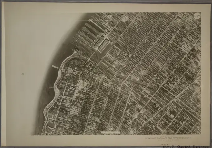
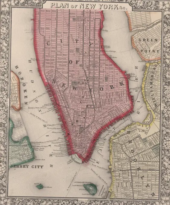
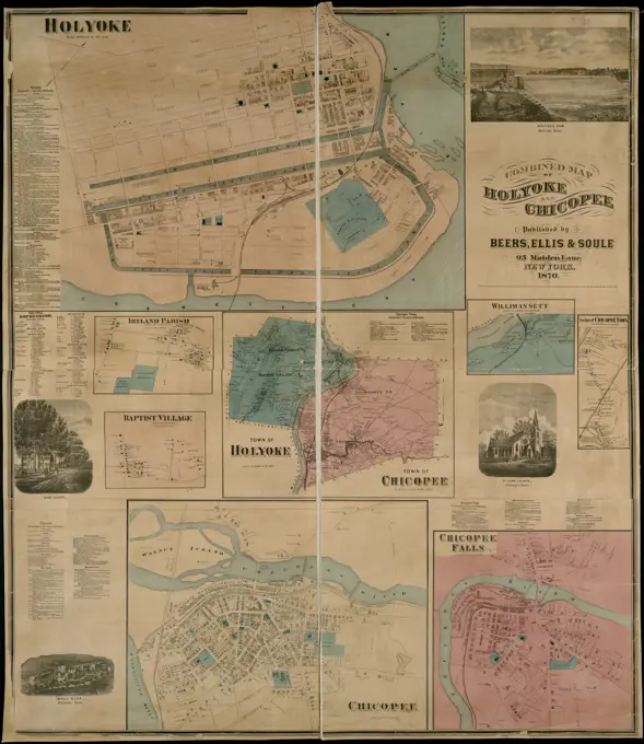
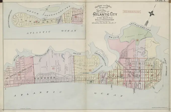
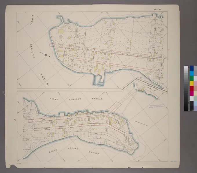
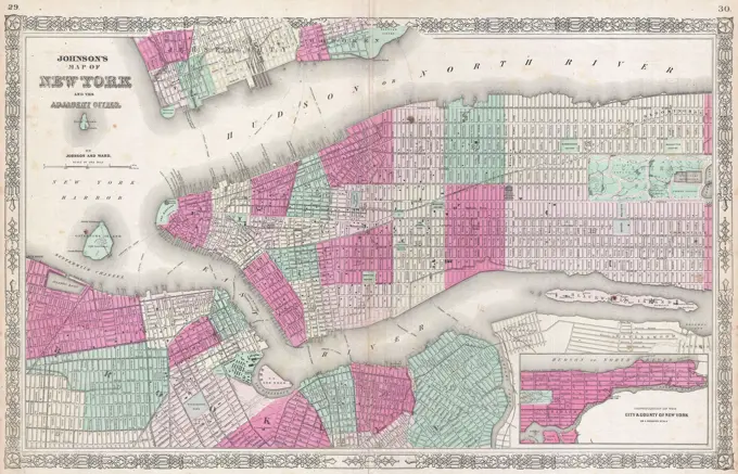
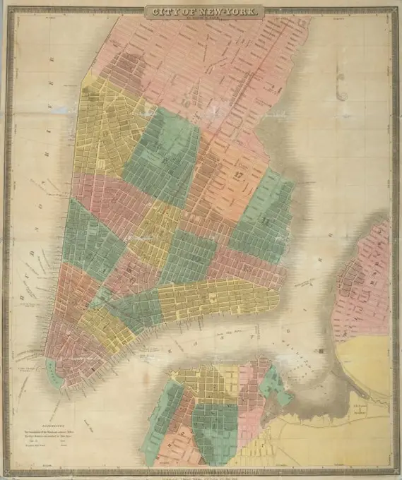
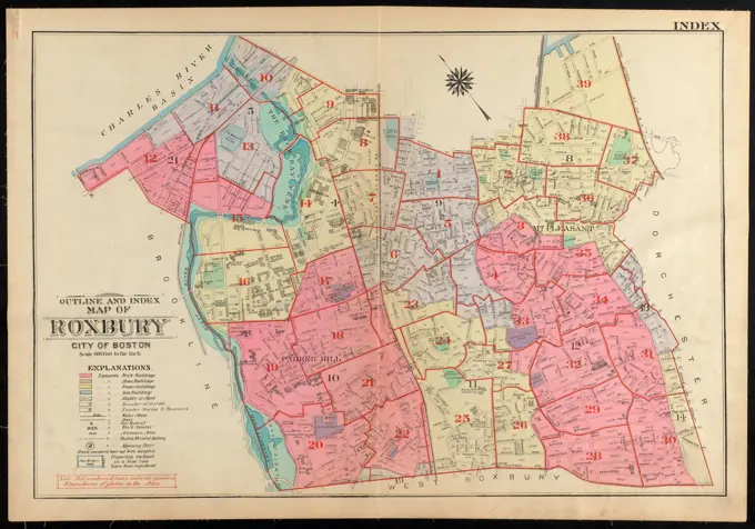
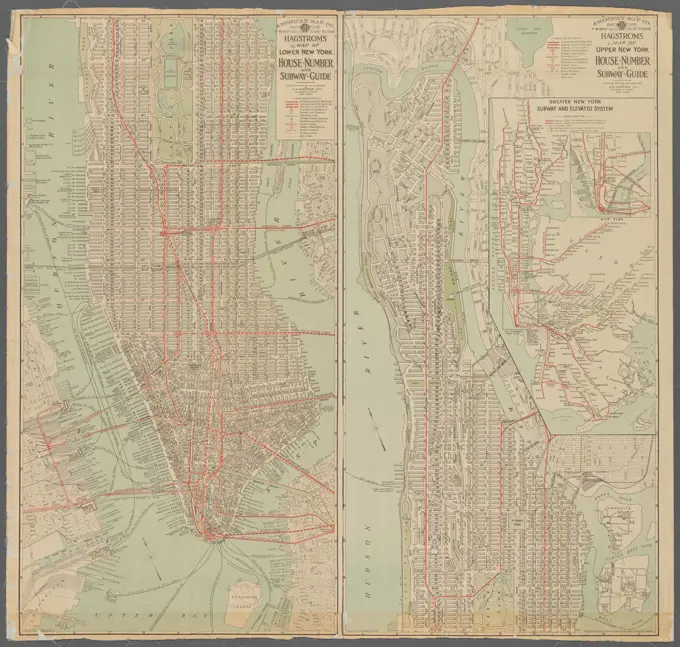
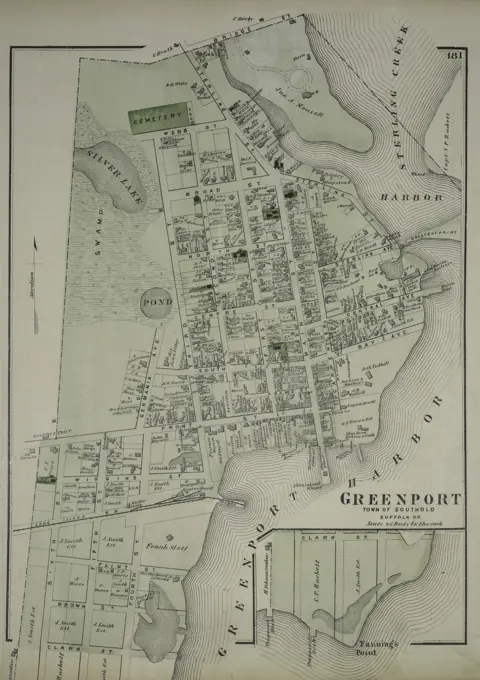
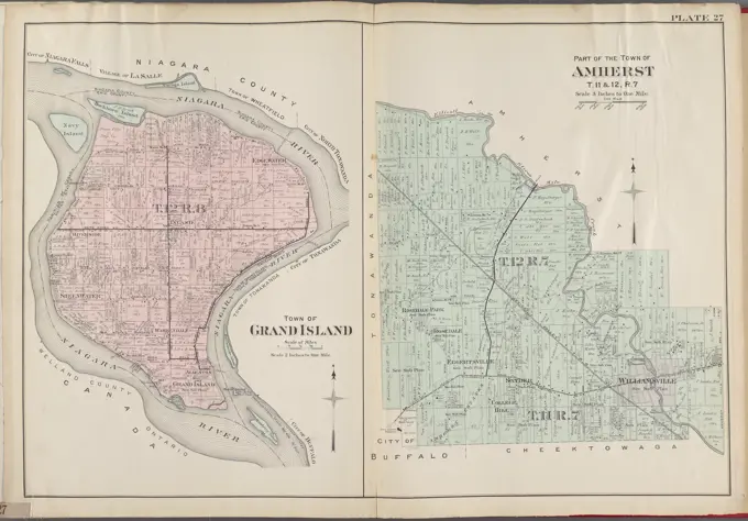
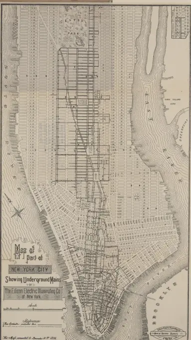
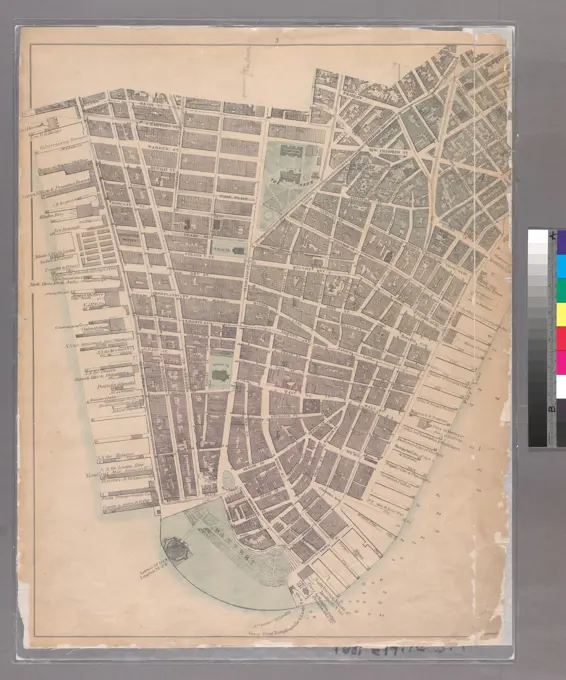
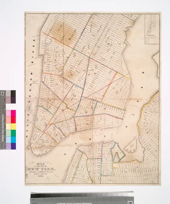
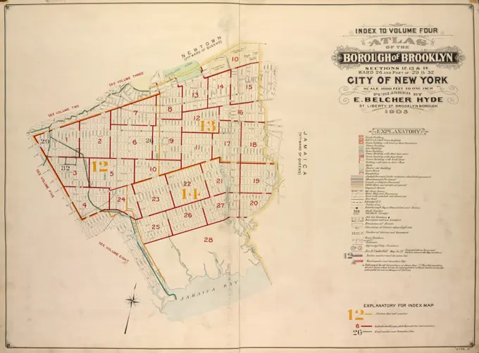
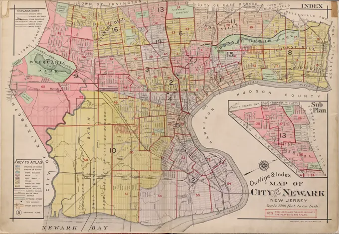
Cartographic Maps of New York

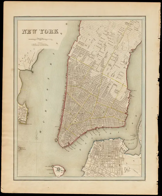
Historical maps featuring detailed layouts of New York areas, showcasing urban geography and property outlines from the late 19th and early 20th centuries.

Map of the borough of Brooklyn, City of New York. Cartographic. Maps. 1920. Lionel Pincus and Princess Firyal Map Division. Brooklyn (New York, N.Y.), Maps
Map of northern part of New York City Cartographic. Maps. 1896. Lionel Pincus and Princess Firyal Map Division. New York (N.Y.), Manhattan (New York, N.Y.), Bronx (New York, N.Y.), Manhattan (New York, N.Y.) , Administrative and political divisions, Ferries , New York (State) , New York, Local transit , New York (State) , New York, Piers , New York (State) , New YorkMap of the town of Eastchester and village of Mount Vernon, Westchester Co., N.Y. Cartographic. Maps. 1876. Lionel Pincus and Princess Firyal Map Division. Real property , New York (State) , Westchester County, Railroads , New York (State) , Westchester County, Landowners , New York (State) , Westchester County, Eastchester (N.Y. : Town), Mount Vernon (Westchester County, N.Y.), Westchester County (N.Y.)City of Toronto, reduced by permission from Wadsworth & Unwin's large map , Toronto Ont., Maps Norman B. Leventhal Map Center CollectionOutline & index map of Roxbury, city of Boston , Boston Mass., Maps, Real property, Massachusetts, Boston, Maps, Landowners, Massachusetts, Boston, Maps, Roxbury Boston, Mass., Maps, Fenway Boston, Mass., Maps, Mission Hill Boston, Mass., Maps, Jamaica Plain Boston, Mass., Maps Norman B. Leventhal Map Center CollectionOld City Map of New York and Manhattan, 1890, USA, Historic, digitally restored reproduction of an original 19th century map, North AmericaPlan of East Boston : exhibiting the land & water lots and other improvements. Oriented with north toward the upper right. "June 1844.".. Plan of East Boston exhibiting the land and water lots and other improvements. Plan of East Boston exhibiting the land and water lots and other improvements, Massachusetts  , Suffolk  ,county   , Boston  , East BostonHobart Town Map 1838? - - Mandatory Photo Credit: TAHO. Map of Milwaukee, Wisconsin , Milwaukee Wis., Maps Norman B. Leventhal Map Center CollectionMap of the consolidated city of Brooklyn Cartographic. Maps. 1867. Lionel Pincus and Princess Firyal Map Division. Brooklyn (New York, N.Y.), Fire alarms , New York (State) , New York, School districts , New York (State) , New York, Railroads , New York (State) , New York, Rivers , New York (State) , New York, Ferries , New York (State) , New York, Canals , New York (State) , New York, New York (State) , New York , BrooklynCartographic, Maps. 1918. Lionel Pincus and Princess Firyal Map Division. Queens (New York, N.Y.), Real property , New York (State) , New York , Queens (Borough) Index map to Volume One A. Atlas of the Borough of Queens Easterly part of Jamaica part of 4th Ward city of New York. Published by E. Belcher Hyde, 5 Beekman St., Manhattan, 97 Liberty St., Brooklyn. 1918.Westchester, Double Page Plate No. 13 Map of Towns of Scarsdale, New Rochelle, and Mamaroneck Cartographic. Atlases, Maps. 1893. Lionel Pincus and Princess Firyal Map Division. Westchester County (N.Y.)Map of the city of Charleston, S.C. and vicinity : with table of reference to principle buildings, points of historical interest. Includes references to points of interest... Map of Charleston, South Carolina and suburbs. Map of Charleston, South Carolina and suburbs, South Carolina  , Charleston  ,county   , CharlestonPlan exhibiting the system of sewerage in the city of Brooklyn, N. Y., to accompany the report of the Brooklyn board of health, issued in 1875. Published by Am. Photo-Litho. Co., Brooklyn, New York. The map measures 87 x 61 cm and is in colorBuffalo, V. 3, Double Page Plate No. 26 Map of Town of Tonawanda Cartographic. Atlases, Maps. 1915. Lionel Pincus and Princess Firyal Map Division. Buffalo Metropolitan Area (N.Y.) , vMaps.New York City, County, and vicinity 1864. Cartographic. Maps. Lionel Pincus and Princess Firyal Map DivisionMap of the town of Niagara Cartographic. Maps, Cadastral maps. 1854. Lionel Pincus and Princess Firyal Map Division. Real property , New York (State) , Niagara (Town), Real property , New York (State) , Niagara Falls (N.Y. and Ont.), Landowners , New York (State) , Niagara (Town), Landowners , New York (State) , Niagara Falls (N.Y. and Ont.), Niagara (N.Y. : Town), Niagara Falls (N.Y.), New York (State) , Niagara Falls (N.Y.), New York (State) , Niagara (Town)Map of New York exhibiting the post offices, post roads, canals, rail roads &c. Cartographic. Maps. 1839. Lionel Pincus and Princess Firyal Map Division. New York (N.Y.), Canals , New York (State), New York (State) , Maps, Railroads , New York (State), New York (N.Y.) , MapsHagstrom's map of Brooklyn (New York City) : house-number and subway guide Cartographic. Maps. 1922. Lionel Pincus and Princess Firyal Map Division. Brooklyn (New York, N.Y.), Railroads , New York (State) , New York, Railroads, Elevated , New York (State) , New York, Streets , New York (State) , New York, Street addresses , New York (State) , New York, Local transit , New York (State) , New York, Brooklyn (New York, N.Y.)New map of Boston, comprising the whole city, with the new boundaries of the wards , Boston Mass., Maps Norman B. Leventhal Map Center CollectionLarge copper mountain chronology. From Carl Sahlin's mountain historical collection.A plan of the city of New-York , Manhattan New York, N.Y., Maps, Early works to 1800, Facsimiles, New York N.Y., Maps, Early works to 1800, Facsimiles Norman B. Leventhal Map Center CollectionMap of the city of Boston. Title supplied by cataloger. Shows places of interest. "Compliments of the United States Hotel, Boston."... , Massachusetts  , Suffolk  ,county   , BostonPlan of New York &c. Plan of New York et cetera. 1860. Cartographic. Maps. Lionel Pincus and Princess Firyal Map Division. New York (N.Y.), Manhattan (New York, N.Y.) , Brooklyn (New York, N.Y.), Greenpoint (New York, N.Y.), Williamsburg (New York, N.Y.), Hoboken (N.J.), Jersey City (N.J.), Buildings , New York (State) , New York (N.Y.), Ferries , New York (State) , New York (N.Y.), Military bases , New York (State) , New York (N.Y.), Parks , New York (State) , New York (N.Y.), Railroads , New York (State) , New York (N.Y.), Streets , New York (State) , New York (N.Y.)Map showing topographical survey of land to be taken for Pelham Bay Park Cartographic. Maps, Topographic maps. 1885. Lionel Pincus and Princess Firyal Map Division. Pelham Bay Park (New York, N.Y.), Parks , New York (State) , Bronx County, Bronx County (N.Y.)A plan of South Boston and the owners lands, and the roads, taken from the original plan now in keeping, being the same plan that one was drawn from, for the Town of Boston in March 1805 , Landowners, Massachusetts, Boston, Maps, Manuscript, South Boston Boston, Mass., Maps, Manuscript, South Boston Boston, Mass. Norman B. Leventhal Map Center CollectionMap of Noord-Holland, Jan van Jagen, Cornelis Bogerts, after Joost Jansz. Bilhamer, 1778 print This map from 1778 was made to a map of Noord-Holland from 1575 (for the second state from 1608, see RP-P-AO-7-2). Along the bottom the title. On the right a cartouche with the title of the original map and the legend in Dutch. To the left of this a standing fisherman with a passer and shooting shelter. Above the cartouche the assignment and a standing farmer's wife at the provincial views, with a ship model, cheeses, vegetables and products from the country. At the bottom in the middle a cartouche with the patent granting of the first state of the original map. The passer on this also serves as a scale: the passer spans a mijle.  paper etching / engraving maps of separate countries or regions. coat of arms (as symbol of the state, etc.). coat of arms (as symbol of the state, etc.) (+ city; municipal) North HollandMap of Boston from the latest surveys. Oriented with north toward the upper right. Relief shown by hachures. Shows wards, streets, cemeteries and railroads. Inset: Plan of East Boston.... , Massachusetts  , Suffolk  ,county   , BostonCartographic, Maps. 1901. Lionel Pincus and Princess Firyal Map Division. Fire insurance , New York (State), Real property , New York (State), Cities & towns , New York (State) KeyOutline and index map of Brighton, wards 25 & 26, city of Boston , Boston Mass., Maps, Real property, Massachusetts, Boston, Maps, Landowners, Massachusetts, Boston, Maps, Brighton Boston, Mass., Maps, Allston Boston, Mass., Maps Norman B. Leventhal Map Center CollectionMap of New York City ,. Robert E. Diefenbach Map CollectionMap of the city of New Haven from surveys, 1862, by Lemuel Swift, Administrative and political divisions, 1 map ; 33 x 33 cm, Published by L.S. Punderson, New Haven, Conn1886 Meiji 19 Japanese Map of Tokyo, JapanMap of the cities of New York and Brooklyn 1869. Cartographic. Maps, Cadastral maps. Lionel Pincus and Princess Firyal Map Division. New York (N.Y.), Manhattan (New York, N.Y.), Real property , New York (State) , New York (N.Y.), Landowners , New York (State) , New York (N.Y.), Buildings , New York (State) , New York (N.Y.), Railroads , New York (State) , New York (N.Y.), Piers , New York (State) , New York (N.Y.)E.B. Hyde & Co.. Cartographic, Maps. 1905. Lionel Pincus and Princess Firyal Map Division. Brooklyn (New York, N.Y.) , Maps, Real property , New York (State) , New York Index to Volume Six. Atlas of the Borough of Brooklyn. Sections 17, 18 & 19. Ward 30. City of New York. E. Belcher Hyde, 97 Liberty St., Brooklyn Borough. 1905.Map of upper New York City and adjacent country showing the city above 125th street, the city of Yonkers, and townships of East Chester, West Chester, Pelham, New Rochelle, and a portion of Mamaroneck., 1889., 48 Exchange Place, New York. Publisher, Hyde & Company. Features railroads, roads, and landowners in the New York Metropolitan Area, including the Bronx, Yonkers, Eastchester, Mount Vernon, Pelham, and New Rochelle., 1 map on 4 sheets, hand-colored; dimensions 158 x 116 cm, sheets 82 x 63 cm or smallerNew York (N.Y.). Bureau of Engineering. Cartographic, Maps. 1924. Lionel Pincus and Princess Firyal Map Division. New York (N.Y.) 22A - N.Y. City (Aerial Set).Hammond's complete map of the Bronx , Local transit, New York State, New York, Maps, Bronx New York, N.Y., Maps Norman B. Leventhal Map Center CollectionCape May City and vicinity, New Jersey , Cape May N.J., Maps Norman B. Leventhal Map Center CollectionPlan of New York, Brooklyn, &c., 1863. Issued in Philadelphia by S. A. Mitchell, JrCombined map of Holyoke and Chicopee. Includes lists of businesses, landowners names, eight maps and four illustrations.... , Massachusetts  , Hampden  ,county   , Chicopee Massachusetts  , Hampden  ,county   , HolyokePlan showing the principal portion of Boston : from the latest authorities , Boston Mass., Maps Norman B. Leventhal Map Center CollectionIndex continued, 1896, A.H. Mueller Co., 1896, Philadelphia, Publisher, A.H. Mueller Co., Atlantic City (N.J.)Jamaica Plain urban renewal area r-49 : proposed land use. Shows residential: medium density; commercial; industrial; institutional, public and private; park or playground, and utility. Inset: Location map.. Part of an urban renewal plan for Boston's Jamaica Plain neighborhood... , Massachusetts  , Suffolk  ,county   , Boston  , Jamaica PlainMap of Baltimore, issued in 1836. 13 x 16 cm. Place of publication PhiladelphiaHammond's new Guide Map of Manhattan and the Bronx 1912. Cartographic. Maps. Lionel Pincus and Princess Firyal Map DivisionBrooklyn Cartographic. Maps. 1874. Lionel Pincus and Princess Firyal Map Division. Brooklyn (New York, N.Y.), Brooklyn City Rail Road Company, Railroads , New York (State) , New YorkCartographic, Maps. 1905. Lionel Pincus and Princess Firyal Map Division. Bronx (New York, N.Y.) Sheet 43: Grid #32000E - 39000E, #4000N - 11000N. Includes City Island, South of Ditmars Street to the South of Schofield Avenue. Planning Grid of the Office of the Topographical Bureau of Bronx.Map of the City of New York : with an index showing the location of prominent buildings and places of interest Cartographic. Maps. 1880 - 1889. Lionel Pincus and Princess Firyal Map Division. Manhattan (New York, N.Y.), Bronx (New York, N.Y.), New York (N.Y.), Buildings , New York (State) , New York (N.Y.), Church buildings , New York (State) , New York (N.Y.), Local transit , New York (State) , New York (N.Y.), Piers , New York (State) , New York (N.Y.), Railroads , New York (State) , New York (N.Y.)Map of New York and vicinity ,. Robert E. Diefenbach Map Collection1865 Johnson Map of New York City and BrooklynMap of the city of Newport and the island of Rhode Island, created between 1870 and 1879 by F.I. Moulton. The map highlights the principal points of interest in and around the city, including drives and other notable locations. It measures 33 x 32 cm, presented on a sheet that is 35 x 33 cm. The publisher is identified as F.I. Moulton, and the map is associated with Newport, Rhode IslandCity of New-York New map of New-York City Cartographic. Maps. 1845. Lionel Pincus and Princess Firyal Map Division. New York (State)New map of the city of Brooklyn: published for the Brooklyn City Directory Cartographic. Maps. 1873. Lionel Pincus and Princess Firyal Map Division. Brooklyn (New York, N.Y.), Brooklyn (New York, N.Y.) , Administrative and political divisions, Railroads , New York (State) , New York, Fire protection districts , New York (State) , New YorkDouble Page Plate No. 8: Long Island Sound - Westchester North to Mt. Vernon - Queens South to Jamaica Cartographic. Atlases, Maps, Maps, Topographic maps. 1891. Lionel Pincus and Princess Firyal Map Division. New York (N.Y.), New York Metropolitan AreaDouble Page Plate No. 4: The Narrows to Jamaica Bay - Coney Island North to Brooklyn Cartographic. Atlases, Maps, Maps, Topographic maps. 1891. Lionel Pincus and Princess Firyal Map Division. New York (N.Y.), New York Metropolitan AreaMap of New York City : showing portions of Brooklyn, Jersey City, and Westchester Co. Rand, McNally & Co.'s new business atlas map of New York City Rand, McNally & Co.'s guide map of New York City Cartographic. Maps. 1896. Lionel Pincus and Princess Firyal Map Division. Manhattan (New York, N.Y.), New York (N.Y.), New York Metropolitan Area, Buildings , New York (State) , New York, Church buildings , New York (State) , New York, Local transit , New York (State) , New York, Piers , New York (State) , New York, Railroads , New York (State) , New YorkMap of the city of Worcester, Mass , Landowners, Massachusetts, Worcester, Maps, Real property, Massachusetts, Worcester, Maps, Worcester Mass., Maps Norman B. Leventhal Map Center CollectionA new & complete map of the city of Boston, with part of Charlestown, Cambridge & Roxbury : from the best authorities. Relief shown by hachures. Oriented with north toward the bottom right. Shows horse railroads, fire district boundaries, fortification and wards... New and complete map of the city of Boston, with part of Charlestown, Cambridge & Roxbury. New and complete map of the city of Boston, with part of Charlestown, Cambridge & Roxbury, Massachusetts  , Suffolk  ,county   , BostonN.N., Map of Marseilles (without Dat.): Map of Marseilles, scale bar. Print colored on paper, 50.6 x 38.3 cm (including scan edges) N.N. : Karte MarseillesHammond's complete map of the Bronx , Local transit, New York State, New York, Maps, Bronx New York, N.Y., Maps Norman B. Leventhal Map Center CollectionCartographic, Maps, Index maps. 1942 - 1957. Lionel Pincus and Princess Firyal Map Division. Real property , New York (State) , New York (N.Y.), Bronx (New York, N.Y.) , Maps Outline and Index Map, Borough of the Bronx. South of 172nd StreetMap of the city of Brooklyn. Distance shown by 1/2 mile radial zones originating at Brooklyn city hall Cartographic. Maps. 1860. Lionel Pincus and Princess Firyal Map Division. Brooklyn (New York, N.Y.)Orange County, Double Page Plate No. 25 Map bounded by Parker Ave., Prospect St., Millburn Ave., Myrtle Ave., Fairview Ter. 1911. Cartographic. Atlases, Maps. Lionel Pincus and Princess Firyal Map Division. Orange (N.J.), East Orange (N.J.), West Orange (N.J.), South Orange (N.J.)Buffalo, V. 3, Double Page Plate No. 4 Map bounded by City of Buffalo, Town of West Seneca, Erie Rail Rd. Cartographic. Atlases, Maps. 1915. Lionel Pincus and Princess Firyal Map Division. Buffalo Metropolitan Area (N.Y.) , vMaps.New York ,. Robert E. Diefenbach Map CollectionOutline and index map of Roxbury, city of Boston , Boston Mass., Maps, Real property, Massachusetts, Boston, Maps, Landowners, Massachusetts, Boston, Maps, Roxbury Boston, Mass., Maps, Fenway Boston, Mass., Maps, Mission Hill Boston, Mass., Maps, Jamaica Plain Boston, Mass., Maps Norman B. Leventhal Map Center CollectionCartographic, Maps. 1907. Lionel Pincus and Princess Firyal Map Division. Staten Island (New York, N.Y.), New York (N.Y.), Real property , New York (State) , New York (N.Y.) Plate 12, Part of Ward 4: Map bound by Pier Line, New York Ave, Lyman Ave, Fingerboard Road, Fletcher St, Oak St, Fox Hill Golf Links, Vanderbilt AveCartographic, Maps. 1888 - 1897. Lionel Pincus and Princess Firyal Map Division. Bronx (New York, N.Y.) Plate 37: Map No. 191 - Map No. 524: Bounded by Devoe St., Public Road to Fordham, (Second & Third Aves.), Orchard St., Highbridge St. and Highbridge Ave. - Map No. 147: Bounded by harlem River Ave., Beach St., Highbridge Ave., ... Bremer Ave. and Macomb Ave. - Map No. 470: Bounded by Highbridge St., Bremer Ave. and Highbridge Ave.Atlas of the city of Chelsea and the towns of Revere & Winthrop, Massachusetts : from actual surveys and official plans : index map , Chelsea Mass., Maps, Revere Mass., Maps, Winthrop Mass., Maps Norman B. Leventhal Map Center CollectionMap of New York City Manhattan with house number guide, subway, elevated, and street-cars 1922. Cartographic. Maps. Lionel Pincus and Princess Firyal Map DivisionCartographic, Maps. 1898. Lionel Pincus and Princess Firyal Map Division. Brooklyn (New York, N.Y.), Real property , New York (State) , New York Double Page Plate No. 23: Bounded by (U.S. Government Reservation) Fort Hamilton Avenue, 86th Street, Bay 2nd Street, Benson Avenue, Delaplaine Street, Atlantic Avenue, (Dyker Beach Park) Seventh Avenue, 170th Street, Battery Avenue, Cropsey Avenue, Dahgreen Place and (Atlantic Avenue) 92nd Street. Part of Ward 30, Land Map Sections, Nos. 17, 18 & 19. Volume 2, Brooklyn Borough, New York City.Map of New York City south of 118th Street., 1858 - 1862Outline and index map of Boston proper and Roxbury , Boston Mass., Maps, Real property, Massachusetts, Boston, Maps, Landowners, Massachusetts, Boston, Maps, Roxbury Boston, Mass., Maps Norman B. Leventhal Map Center CollectionGreenport, Town of Southold, Suffolk Co., 1873, Beers, Comstock & Cline., 1873., New York. Publisher, Beers, Comstock & Cline. Long Island (N.Y.). Description and travelNuova pianta della cittá e porto franco di Venezia , Venice Italy, Maps Norman B. Leventhal Map Center CollectionBuffalo, V. 3, Double Page Plate No. 27 Map of Town of Grand Island, Part of the town of Amherst Cartographic. Atlases, Maps. 1915. Lionel Pincus and Princess Firyal Map Division. Buffalo Metropolitan Area (N.Y.) , vMaps.Bird's eye view of the city of Portland, Maine, 1876 , Portland Me., Aerial views Norman B. Leventhal Map Center CollectionProfile of Amsterdam with a map of the blockade by the troops of Willem II, 1650, 1654 print Leaf with a profile of Amsterdam at the top, with soldiers standing on pedestals on poldets, the legends A-H and 1-10. Below a map of the blockade of Amsterdam by the troops of Prince William II, from 20 July to 4 August 1650. Map of Amsterdam with the surrounding area, right Haarlem, Left Muiden and Weesp. The different army places of the troops are indicated on the map. Left on the Zuiderzee near Pampus different ships with name indicated. A inscription is written by hand under the plate. print maker: Northern Netherlandspublisher: Amsterdam paper etching / engraving / writing (processes) maps of separate countries or regions Amsterdam. North HollandBird's eye view of the city of Portland, Maine, 1876 , Portland Me., Aerial views Norman B. Leventhal Map Center CollectionNew map of New York City : from the latest authentic surveys, showing all ferries, and all steamship docks both foreign and coastwise lines , Local transit, New York State, New York, Maps, Ferries, New York State, New York, Maps, Railroads, New York State, New York, Maps, New York N.Y., Maps, Manhattan New York, N.Y., Maps Norman B. Leventhal Map Center CollectionMap of part of New York City showing underground mains of The Edison Electric Illuminating Co. of New York, published in 1894. The map indicates underground utility lines in New York, measuring 38 x 21 cm1937 World War II Japanese Map of Shanghai, China (w-photo of Bund)Historical city map, 1896, New York, United StatesCartographic, Maps. 1867. Lionel Pincus and Princess Firyal Map Division Sheet 3: Bounded by Reade Street, Nassau Street, Pearl Street, Chatham Street, Oliver Street, (Pier Line) South Street, (Battery) State Street, Battery Place and West Street.Map of Pittsburg and Allegheny, Pa. Shows county boundaries, names of streets and points of interest, drainage, railroads and street car lines. Includes references. On verso: Index and text on Pittsburg with popluation census figure for 1890.... , Pennsylvania  , Allegheny  ,county   , Pittsburg North SideMap of New York City (Manhattan) with house number guide, subway, elevated and street-cars 1922. Cartographic. Maps. Lionel Pincus and Princess Firyal Map DivisionThe Albemarle Hotel map of Manhattan, New York City : with index of streets and strangers' directory to business houses, public buildings, principal churches, places of amusement, etc. etc. Map of Manhattan, New York City on face of map: Albemarle Hotel map of Manhattan, City of New York Cartographic. Maps. 1901. Lionel Pincus and Princess Firyal Map Division. Manhattan (New York, N.Y.) , Maps, TouristMap of the city of New York. Cartographic. Maps. 1850. Lionel Pincus and Princess Firyal Map Division. New York (N.Y.), Manhattan (New York, N.Y.) , Maps, Fire protection districts , New York (State) , New York, New York (N.Y.) , Administrative and political divisions , Maps, New York (N.Y.) , MapsGuide map of Chicago, October 11th, 1871 , Railroads, Illinois, Chicago, Maps, Great Fire, Chicago, Ill., 1871, Maps, Chicago Ill., Maps Norman B. Leventhal Map Center CollectionE.B. Hyde & Co.. Cartographic, Maps. 1905. Lionel Pincus and Princess Firyal Map Division. Brooklyn (New York, N.Y.) , Maps, Real property , New York (State) , New York Index to Volume Four. Atlas of the Borough of Brooklyn. Sections 12, 13 & 14. Wards 26 and part of 29 & 32. City of New York. E. Belcher Hyde, 97 Liberty St., Brooklyn Borough. 1904.Map of Washington, D.C., and environs : with marginal numbers and measuring tape attachment for instantly locating points of interest within a radius of twenty miles from the Capitol 1887Index Continued (Left Pg.) Cartographic. Atlases, Maps. 1911-12. Lionel Pincus and Princess Firyal Map Division. Newark (N.J.)Cartographic, Maps. 1908 - 1913. Lionel Pincus and Princess Firyal Map Division. Queens (New York, N.Y.), Long Island City (New York, N.Y.) Index map to Vol. 3; Atlas of the Borough of Queens Third Ward city of New York. Published by E. Belcher Hyde; 97 Liberty St., Brooklyn Borough. 1904.A map of the State of New York : exhibiting the situation and boundaries of the counties and towns, and the number of inhabitants in each, according to the census of 1840 ... Cartographic. Maps. 1842. Lionel Pincus and Princess Firyal Map Division. New York (N.Y.) , Administrative and political divisions, New York (State) , Administrative and political divisions, New York (State) , Census, 1840A new & accurate plan of the city of New York in the state of New York in North America. Relief shown by hachures. Depths shown by soundings. Shows wards, streets, wharves, buildings, and ferry routes with distances. Ward names highlighted in pink. Inset at lower right: A view of the city from Long Island. Below inset is a brief geographical description of New York. Includes note... New and accurate plan of the city of New York in the state of New York in North America. New and accurate plan of the city of New York in the state of New York in North America, New York  , New YorkCartographic, Maps. 1893. Lionel Pincus and Princess Firyal Map Division. New York (N.Y.) Outline & index map of the City of New York, lying south of Fourteenth St.New York (N.Y.). Department of Parks. Topographical Division. Cartographic, Maps. 1873. Lionel Pincus and Princess Firyal Map Division. Westchester County (N.Y.), New York (N.Y.) Bronx, Topographical Map Sheet 7; Map bounded by Inwood St., Hampden St., Macombs Road, Washington Bridge; Including 181 St., River St., Kingsbridge BroadwayOutline & index map of Dorchester, the city of Boston , Boston Mass., Maps, Real property, Massachusetts, Boston, Maps, Landowners, Massachusetts, Boston, Maps, Dorchester Boston, Mass., Maps Norman B. Leventhal Map Center CollectionMap of Boston : from the latest surveys , Boston Mass., Maps Norman B. Leventhal Map Center CollectionRand McNally standard map of Toronto and environs , Toronto Ont., Maps Norman B. Leventhal Map Center Collection