City Atlas Maps of Boston

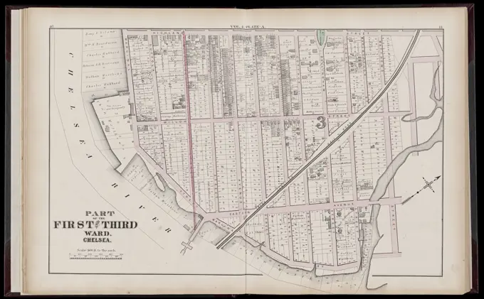
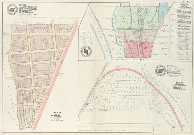
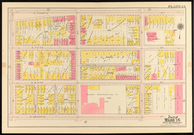
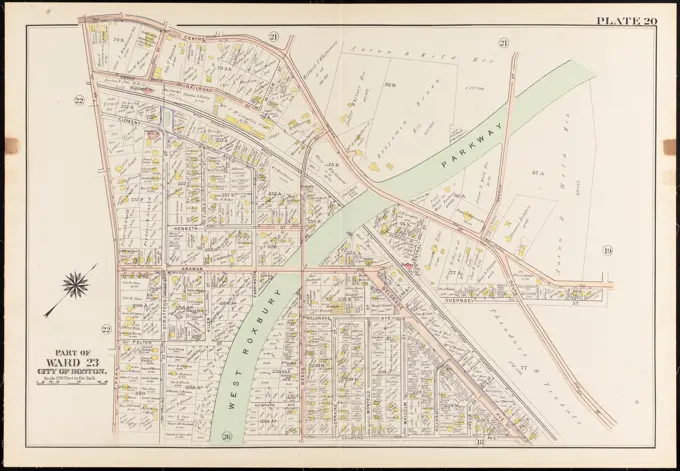
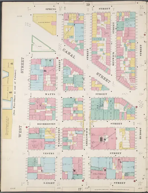
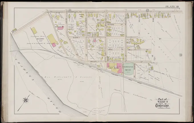
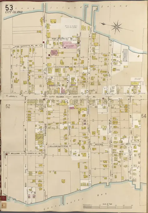
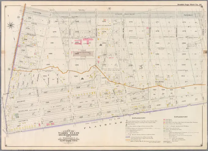
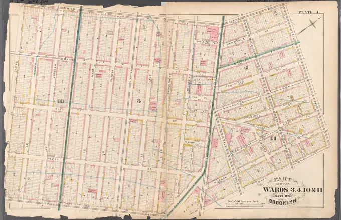
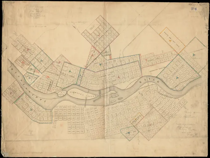
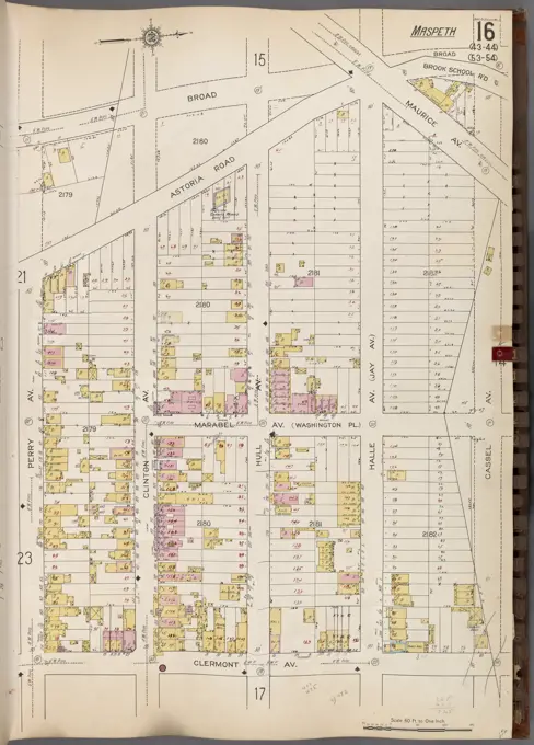
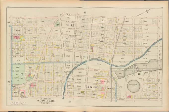
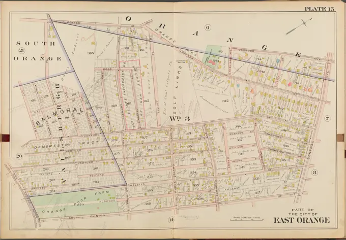
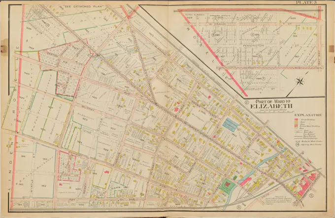
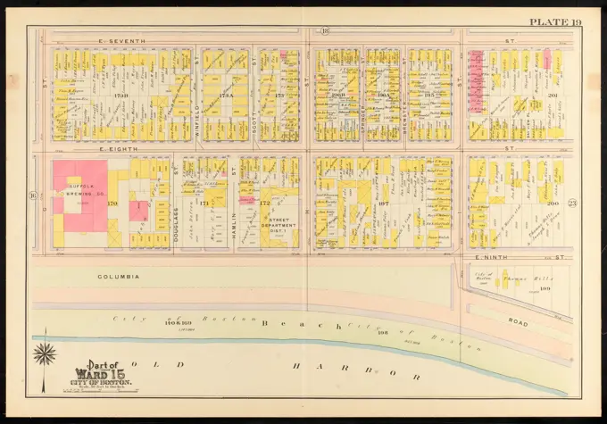
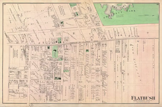
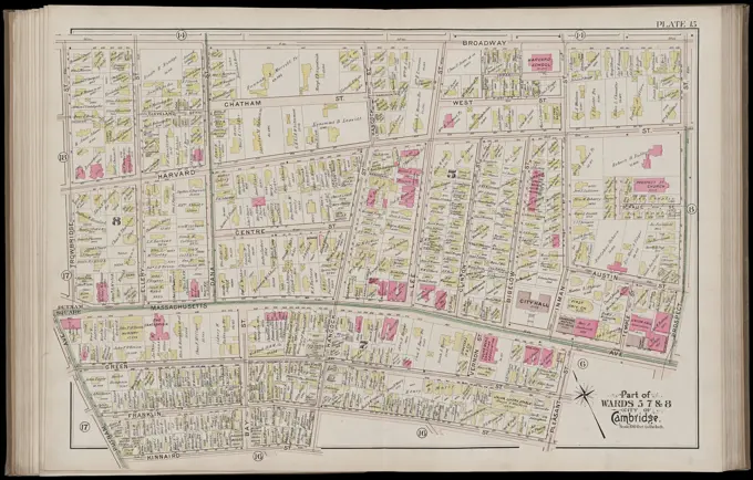
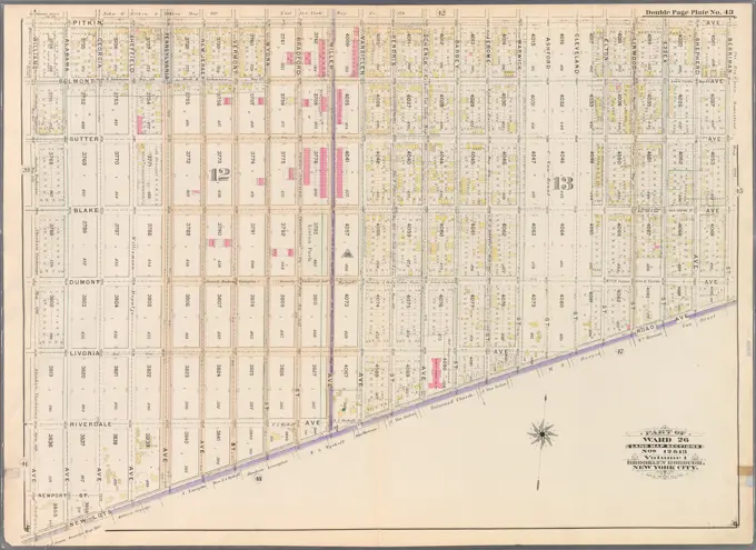
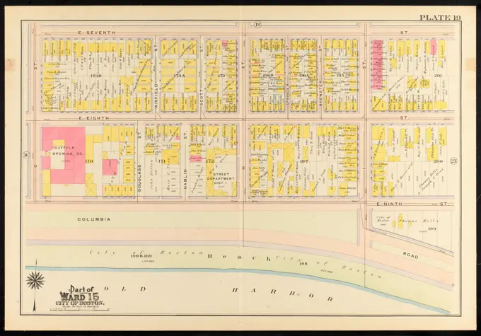
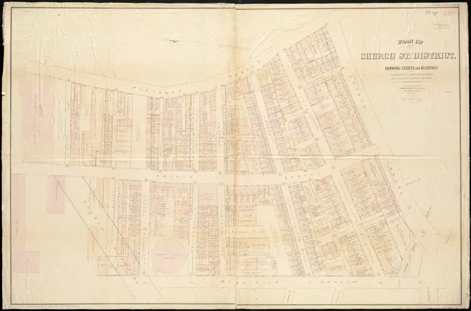
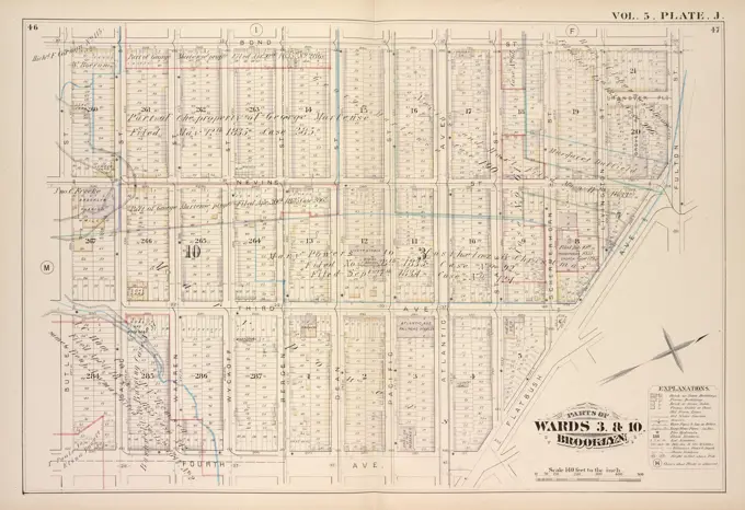
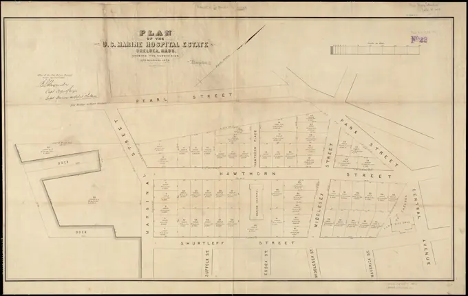
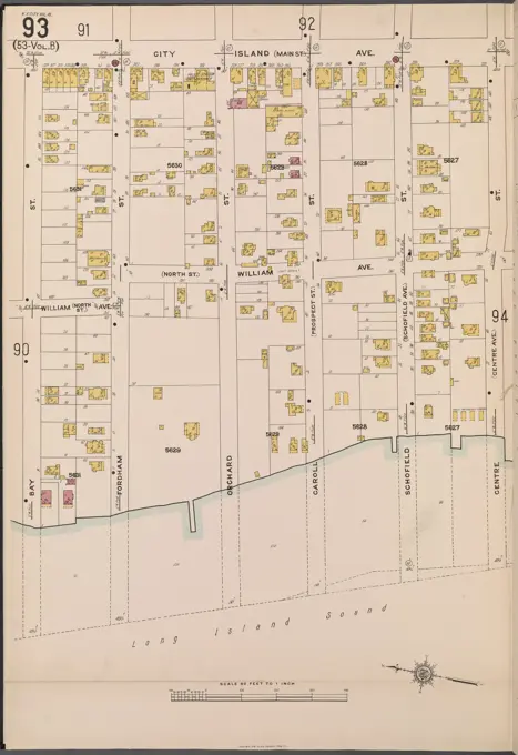
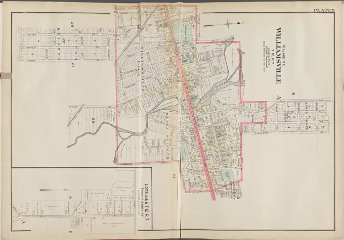
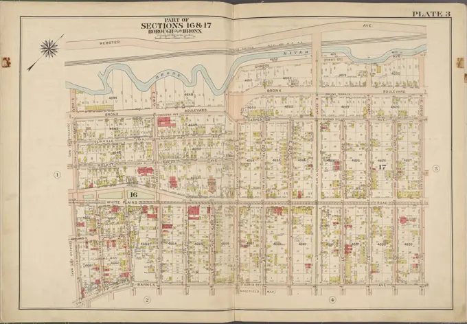
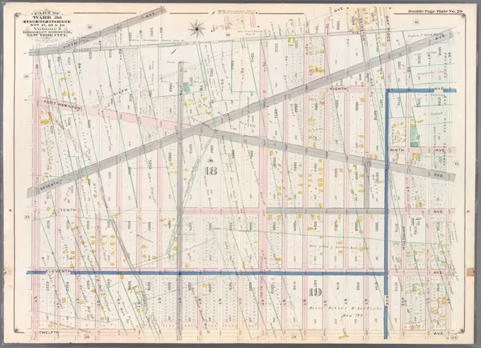
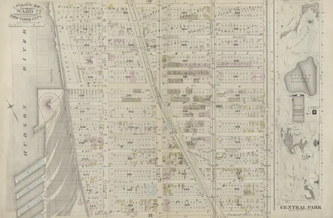
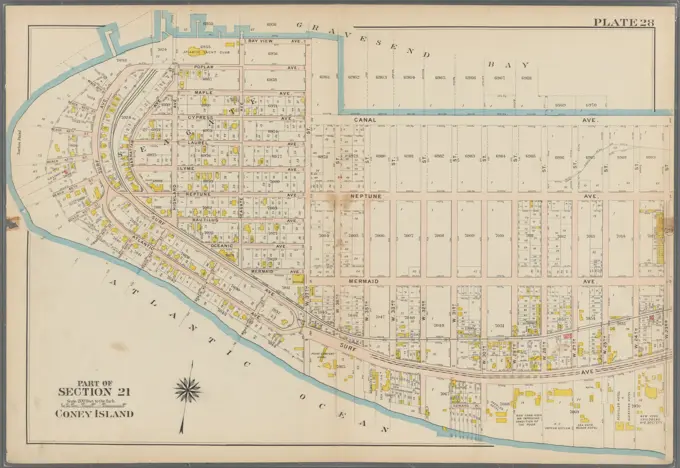
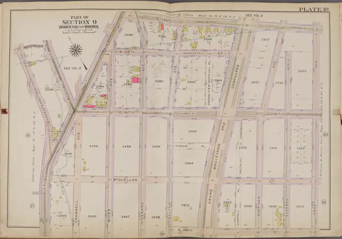
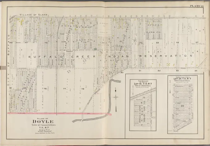
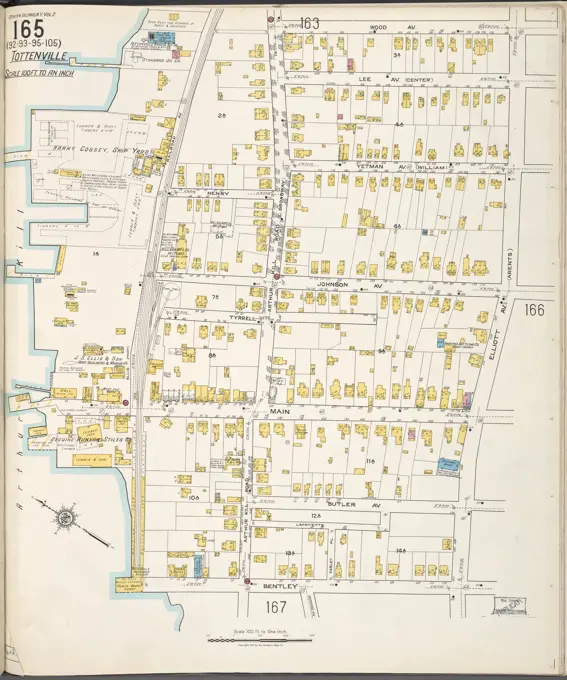
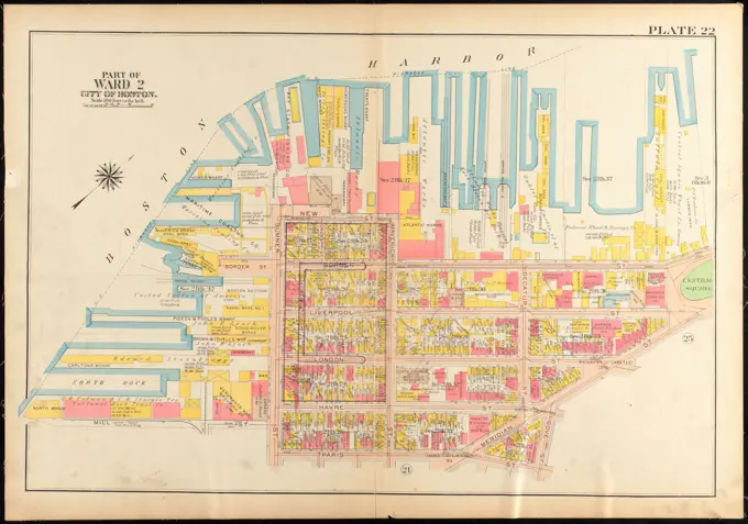
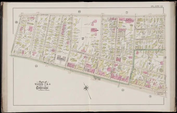
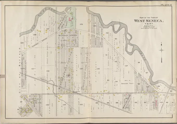
Detailed maps from the Boston area, showcasing land ownership and property details across various wards in the late 19th century.

Atlas of the city of Boston, Dorchester : plate 30 , Boston Mass., Maps, Real property, Massachusetts, Boston, Maps, Landowners, Massachusetts, Boston, Maps, Dorchester Boston, Mass., Maps Norman B. Leventhal Map Center Collection
Bromley, George Washington. Cartographic, Maps, Atlases, land surveys. 1907. Lionel Pincus and Princess Firyal Map Division. Brooklyn (New York, N.Y.) , Maps Plate 22: Bounded by (Vanderveer Park) Farragut Road, Paerdegat Avenue, E. 42nd Street, Avenue J. and Ocean Avenue Plate 22Atlas of the county of Suffolk, Massachusetts : vol. 4th including East Boston, city of Chelsea, Revere and Winthrop : from actual survey official records & private plans : plate A , Real property, Massachusetts, Chelsea, Maps, Landowners, Massachusetts, Chelsea, Maps, Chelsea Mass., Maps Norman B. Leventhal Map Center CollectionCartographic, Maps. 1886. Lionel Pincus and Princess Firyal Map Division. Brooklyn (New York, N.Y.), Real property , New York (State) , New York Plate 34: Bounded by Fourth Avenue, 38th Street, Eighth Avenue, 47th Street, Seventh Avenue (New Utrecht) and 59th Street. Plate 34: Part of Ward 8. Brooklyn, N.Y.Plate 7 Map No. 148 Bounded by Ella St., Rail Road Ave., Juliet St., and Morrisania Av. - Map No. 509 Bounded by (West Morrisania) Melrose Street, Morris St., Mott St., and Harlem River. - Map No. 242 Bounded by Cortland Ave., First St., Rail Road Ave., and William St., 1888 - 1897, New York, Publisher, E. Robinson Co., Bronx (New York, N.Y.)Cartographic, Maps. 1899. Lionel Pincus and Princess Firyal Map Division. Brooklyn (New York, N.Y.), Real property , New York (State) , New York Double Page Plate No. 3: Bounded by (Gravesend Bay) Warehouse Ave., Twenty Third Ave., 84th St., Twenty Fourth Ave., Stillwell Ave., Avenue Y and (Harway Basin) Bay 47th St. Part of Ward 31, Land Map Section, No. 21, Volume 3, Brooklyn Borough, New York CityAtlas of the city of Boston, South Boston : plate 24 , Boston Mass., Maps, Real property, Massachusetts, Boston, Maps, Landowners, Massachusetts, Boston, Maps Norman B. Leventhal Map Center CollectionCartographic, Maps. 1917. Lionel Pincus and Princess Firyal Map Division. Staten Island (New York, N.Y.) Plate 36, Part of Wards 1, 2 & 3 Map bound by Forest Hill Road (Fort Richmond), Willow Brook Road (Gun Factory RD), Caswell Ave, Harvey Ave, Marble St, Byrne Ave, Buchanan Ave, Delmont St, Cedar Ave, Washington Ave, BroadwayAtlas of the city of Boston, West Roxbury : plate 20 , Boston Mass., Maps, Real property, Massachusetts, Boston, Maps, Landowners, Massachusetts, Boston, Maps, West Roxbury Boston, Mass., Maps Norman B. Leventhal Map Center CollectionCartographic, Maps. 1894. Lionel Pincus and Princess Firyal Map Division. Fire insurance , New York (State), Real property , New York (State), Cities & towns , New York (State) Manhattan, V. 1, Double Page Plate No. 18 Map bounded by Spring St., Clarke St., Sullivan St., Laight St., West St.Atlas of the city of Cambridge, Massachusetts : from actual surveys and official plans. plate 10 , Real property, Massachusetts, Cambridge, Maps, Landowners, Massachusetts, Cambridge, Maps, Cambridge Mass., Maps Norman B. Leventhal Map Center CollectionCartographic, Maps. 1905 - 1908. Lionel Pincus and Princess Firyal Map Division. New York (N.Y.) Bronx, V. B, Plate No. 53 Map bounded by Long Island Sound, Centre St., Eastchester Bay, Bay St., Tier St.Vol. 2. Plate, B. Map bound by Meeker Ave., Newtown Creek, Division Pl., Vandervoort Ave.; Including Townsend St., Thomas St., Cherry St., Anthony St., Lombardy St., Beadel St., Porter Ave., Varick Aver, Stewart Ave., Cardner Ave., Scott Ave.Cartographic, Maps. 1898. Lionel Pincus and Princess Firyal Map Division. Brooklyn (New York, N.Y.), Real property , New York (State) , New York Double Page Plate No. 16: Bounded by Eastern Parkway, Albany Avenue, East New York Avenue, Lincoln Road, Washington Avenue, Sullivan Street and Franklin Avenue. Part of Wards 24 & 29. Land Map Section, No. 5, Volume 1, Brooklyn Borough, New York City.Cartographic, Maps. 1911. Lionel Pincus and Princess Firyal Map Division. Bronx (New York, N.Y.), New York (N.Y.) Plate 12 Map bounded by Southern Blvd., Bronx RiverCartographic, Maps. 1898. Lionel Pincus and Princess Firyal Map Division. Brooklyn (New York, N.Y.), Real property , New York (State) , New York Double Page Plate No. 40: Bounded by Cornelia Street, Irving Avenue, Halsey Street, Knickerbocker Avenue, Chauncey Street, Hamburg Avenue, Granite Street, Evergreen Avenue, Cooper Street and Broadway. Part of Wards 28. Land Map Section, No. 11, Volume 1, Brooklyn Borough, New York City.Cartographic, Maps. 1913. Lionel Pincus and Princess Firyal Map Division. Bronx (New York, N.Y.), New York (N.Y.) Plate 39 Map bounded by Lafayette Ave., Westchester Creek, O'Brien Ave, Taylor Ave.Atlas of the city of Boston, West Roxbury : from actual surveys and official plans : plate 17 , Real property, Massachusetts, Boston, Maps, Landowners, Massachusetts, Boston, Maps, Roslindale Boston, Mass., Maps Norman B. Leventhal Map Center CollectionPart of Wards 29 & 32, Land Map Section, No. 15. Volume 2, Brooklyn Borough, New York City.Atlas of the city of Boston : East Boston, Mass. : plate 33 , Boston Mass., Maps, Real property, Massachusetts, Boston, Maps, Landowners, Massachusetts, Boston, Maps, East Boston Boston, Mass., Maps Norman B. Leventhal Map Center CollectionCartographic, Maps. 1880. Lionel Pincus and Princess Firyal Map Division. Brooklyn (New York, N.Y.), Real property , New York (State) , New York Plate 4: Bounded by Smith Street, Jay Street, Myrtle Avenue, Navy Street, Fulton Street, Flatbush Avenue, Third Avenue and Baltic Street. Plate 4: Part of Wards 3, 4, 10, & 11. City of Brooklyn.Map of the city of St. Anthony ; map of Minneapolis ; map of St. Anthony. Preliminary printing with manuscript corrections, title, imprint and scale. Cadastral map. Relief shown by hachures. Oriented with north to the upper left.... , Minnesota  , Hennepin  ,county   , Minneapolis Minnesota  , Hennepin  ,county   , Saint AnthonyAtlas of the city of Boston, Roxbury : plate 29 , Boston Mass., Maps, Real property, Massachusetts, Boston, Maps, Landowners, Massachusetts, Boston, Maps, Roxbury Boston, Mass., Maps Norman B. Leventhal Map Center CollectionCartographic, Maps. 1884 - 1936. Lionel Pincus and Princess Firyal Map Division. Fire insurance , New York (State), Real property , New York (State), Cities & towns , New York (State) Queens V. 3, Plate No. 16 Map bounded by Broad, Cassel Ave., Clermont Ave., Perry Ave.Atlas of the city of Boston, Dorchester : plate 15 , Boston Mass., Maps, Real property, Massachusetts, Boston, Maps, Landowners, Massachusetts, Boston, Maps, Roxbury Boston, Mass., Maps Norman B. Leventhal Map Center CollectionCartographic, Maps. 1852. Lionel Pincus and Princess Firyal Map Division. Manhattan (New York, N.Y.), Real property , New York (State) , New York, Fire insurance Plate 8: Map bounded by West Street, Reade Street, Hudson Street, College Place, Barclay Street, Greenwich Street, Vessey StreetE.B. Hyde & Co.. Cartographic, Maps. 1916. Lionel Pincus and Princess Firyal Map Division. Brooklyn (New York, N.Y.), Real property , New York (State) , New York, Maps Brooklyn, Vol. 2, Double Page Plate No. 26; Part of Ward 30, Sections 18 & 19; Map bounded by 86th St., 17th Ave., Gravesend Bay; Including Bay 8th St., 7th Ave.Atlas of the city of Boston, Dorchester : from actual surveys and official plans : plate 24 , Real property, Massachusetts, Boston, Maps, Landowners, Massachusetts, Boston, Maps, Dorchester Boston, Mass., Maps Norman B. Leventhal Map Center CollectionEssex County, Left Page Plate: Map bounded by N. 6th St., Dickerson St., Norfolk St., Bank St. Cartographic. Atlases, Maps. 1881. Lionel Pincus and Princess Firyal Map Division. Essex County (N.J.), Real property , New Jersey , Essex CountyCartographic, Maps. 1884 - 1936. Lionel Pincus and Princess Firyal Map Division. Fire insurance , New York (State), Real property , New York (State), Cities & towns , New York (State) Queens V. 10, Plate No. 96 Map bounded by Colonial Ave., Quality, Marlowe Ave., YaluPart of the city of East Orange. Double Page Plate No. 15 Map bounded by Center St., Oakwood Ave., Central Ave., S. Clinton St., S. Orange Ave. Cartographic. Atlases, Maps, Cadastral maps. 1904. Lionel Pincus and Princess Firyal Map Division. Essex County (N.J.), Real property , New Jersey , Essex County (N.J.)Plan of lands belonging to the Boston Water Power Co , Real property, Massachusetts, Boston, South End, Maps, South End Boston, Mass., Maps, Boston Mass., Maps Norman B. Leventhal Map Center CollectionUnion County, Double Page Plate No. 3 Map bounded by West Grand St., Broad St., Fay Ave. 1906. Bauer, Jacob L.. Cartographic. Atlases, Maps. Lionel Pincus and Princess Firyal Map Division. Union County (N.J.)Rüster Emil (1883-1949), residential building Prof. Rüster, Berlin-Grunewald (1934): site plan. Ink and colored pencil on paper, 20.8 x 28.8 cm (including scan edges) Rüster Emil  (1883-1949): Wohnhaus Prof. Rüster, Berlin-GrunewaldHudson County, V. 8, Double Page Plate No. 23 Map bounded by Bulls Ferry Rd., Hudson River, Hudson Ave. 1887. Cartographic. Atlases, Maps. Lionel Pincus and Princess Firyal Map Division. Hudson County (N.J.)Atlas of the city of Boston, ward 26, Hyde Park : plate 4 , Boston Mass., Maps, Real property, Massachusetts, Boston, Maps, Landowners, Massachusetts, Boston, Maps, Hyde Park Boston, Mass., Maps Norman B. Leventhal Map Center CollectionCartographic, Maps. 1884 - 1936. Lionel Pincus and Princess Firyal Map Division. Fire insurance , New York (State), Real property , New York (State), Cities & towns , New York (State) Queens V. 5, Plate No. 97 Map bounded by Alexander St., Montauk Ave., 8th St., BroadwayCartographic, Maps. 1880. Lionel Pincus and Princess Firyal Map Division. Brooklyn (New York, N.Y.), Real property , New York (State) , New York Vol. 5. Plate, B. Map bound by East River, Bridge St., Sands St., Poplar St.; Including Marshall St., John St., PLymouth St., Water St., Front St., Fulton St., Doughty St., Vine St., York St., Franklin Pl., Talman St., Prospect St., Furman St., Columbia Heights, Elizabeth Pl., Dock St., McKenney St., Hicks St., Garrison St., Main St., Flint St., Washington St., Adams St., Pearl St., Jay St.Atlas of the city of Boston, West Roxbury : plate 19 , Boston Mass., Maps, Real property, Massachusetts, Boston, Maps, Landowners, Massachusetts, Boston, Maps, West Roxbury Boston, Mass., Maps Norman B. Leventhal Map Center CollectionAtlas of the city of Boston, South Boston : plate 19 , Boston Mass., Maps, Real property, Massachusetts, Boston, Maps, Landowners, Massachusetts, Boston, Maps Norman B. Leventhal Map Center CollectionCartographic, Maps. 1919. Lionel Pincus and Princess Firyal Map Division. Queens (New York, N.Y.), Real property , New York (State) , New York , Queens (Borough) Queens, V. 2, Double Page Plate No. 10; Part of Long Island City, Ward 1; Map bounded by Winthrop Ave., 11th Ave., Woolsey Ave., East River1873 Beers Map of Flabush Area of Brooklyn, New York City, including Prospect ParkJersey City, V. 4, Double Page Plate No. 34 Map bounded by Nelson Ave., North St., Summit Ave., Charles St. Cartographic. Atlases, Maps. 1873. Lionel Pincus and Princess Firyal Map Division. Jersey City (N.J.), Fire insurance , New Jersey , Jersey CityCartographic, Maps. 1905 - 1908. Lionel Pincus and Princess Firyal Map Division. New York (N.Y.) Bronx, V. B, Plate No. 48 Map bounded by Eastchester Bay, City Island Rd.Cartographic, Maps. 1891. Lionel Pincus and Princess Firyal Map Division. Fire insurance , New York (State), Real property , New York (State), Cities & towns , New York (State) Bronx, V. 10, Double Page Plate No. 212 Map bounded by Trinity Ave., E. 163rd St., Prospect Ave., E. 156th St.Atlas of the city of Cambridge, Massachusetts : from actual surveys and official plans. plate 15 , Real property, Massachusetts, Cambridge, Maps, Landowners, Massachusetts, Cambridge, Maps, Cambridge Mass., Maps Norman B. Leventhal Map Center CollectionAtlas of the city of Boston, South Boston : plate 10 , Boston Mass., Maps, Real property, Massachusetts, Boston, Maps, Landowners, Massachusetts, Boston, Maps Norman B. Leventhal Map Center CollectionVol. 6. Plate, F. Map bound by Newtown Creek, Charlick St., Bridgewater St., Meserole Ave., Kingsland Ave., Norman Ave., Humboldt St., Whale Creek Canal; Including Sutton St., Wallock St., Leyden St., Monitor St., Henry Pl., N. Henry St., Holland St., R.Plate 33: Map bounded by Franklin Street, West Broadway, Reade Street, West Street. 1852, 1854, William Perris, New York, N.Y., USA.Cartographic, Maps. 1879. Lionel Pincus and Princess Firyal Map Division. Real property , New York (State) , New York Plate 7:: Bounded by Avenue B, E. 14th Street, Avenue A, E. 23rd Street, (East River) Avenue D, E. 8th Street, Lewis Street and E. 4th Street. Part of Wards 11 & 18. New York City.Cartographic, Maps. 1898. Lionel Pincus and Princess Firyal Map Division. Brooklyn (New York, N.Y.), Real property , New York (State) , New York Double Page Plate No. 43: Bounded by Pitkin Avenue, Berriman Street, New Lots Avenue and Williams Avenue. Part of Ward 26. Land Map Sections, Nos. 12 & 13. Volume 1, Brooklyn Borough, New York City.Atlas of the city of Boston, South Boston : plate 19 , Boston Mass., Maps, Real property, Massachusetts, Boston, Maps, Landowners, Massachusetts, Boston, Maps Norman B. Leventhal Map Center CollectionMap of the city of Sheboygan, Wisconsin showing all the recent improvements. Shows lots. Color manuscript indicating wards, catholic churches, schools, and railroads.... , Wisconsin  , Sheboygan  ,county   , SheboyganCartographic, Maps. 1884 - 1936. Lionel Pincus and Princess Firyal Map Division. Fire insurance , New York (State), Real property , New York (State), Cities & towns , New York (State) Queens V. 10, Plate No. 95 Map bounded by Colonial Ave., Yalu, Marlowe Ave., RodmannSt. James Cartographic. Atlases, Maps. 1915 - 1917. Lionel Pincus and Princess Firyal Map Division. Suffolk County (N.Y.)Plan of Church St. district, showing estates and buildings : as proposed to be taken by the city of Boston under the Act of the Legislature of June 1st, 1867 , Real property, Massachusetts, Boston, Maps, Streets, Massachusetts, Boston, Maps, South End Boston, Mass., Maps, Boston Mass., Maps Norman B. Leventhal Map Center CollectionCartographic, Maps. 1880. Lionel Pincus and Princess Firyal Map Division. Brooklyn (New York, N.Y.), Real property , New York (State) , New York Vol. 5. Plate, J. Map bound by Bond St., Fulton St., Flatbush Ave., Fourth Ave., Butler St.; Including Nevins St., Hanover Pl., Third Ave., Baltic St., Warren St., Wyckoff St., Bergen St., Dean St., Pacific St., Atlantic Ave., State St., Schermerhorn St., Livingston St.Cartographic, Maps. 1884 - 1936. Lionel Pincus and Princess Firyal Map Division. Fire insurance , New York (State), Real property , New York (State), Cities & towns , New York (State) Staten Island, V. 1, Plate No. 39 Map bounded by Virginia Ave., Hope Ave., Lincoln Pl.Plan of the U.S. Marine Hospital estate Chelsea, Mass : showing the subdivision into the buildings lots. Oriented with north toward the upper right. "Office of the New Marine Hospital, Boston, April 2nd, 1857."... , Massachusetts  , Suffolk  ,county   , Boston Massachusetts  , Suffolk  ,county   , ChelseaCartographic, Maps. 1884 - 1936. Lionel Pincus and Princess Firyal Map Division. Fire insurance , New York (State), Real property , New York (State), Cities & towns , New York (State) Staten Island, V. 1, Plate No. 38 Map bounded by Chestnut Ave., Upper New York Bay, Bayview Ave., St. Johns Ave.Queens, Vol. 2, Double Page Plate No. 22; Part of Ward Two Corona and Louona Park; Map bounded by Bowery Road, Old Bowery Road, Flushing and Astoria Road, Jackson Ave., Coddington PL.; Including Park Ave., Flushing and Newtown Turnpike, Lent.Cartographic, Maps. 1918. Lionel Pincus and Princess Firyal Map Division. Fire insurance , New York (State), Real property , New York (State), Cities & towns , New York (State) Bronx, V. 18, Plate No. 93 Map bounded by City Island Ave., Centre St., Long Island Sound, Bay St.City atlas of Boston, Massachusetts : complete in one volume : from official records, private plans and actual surveys : plate 16 , Real property, Massachusetts, Boston, Maps, Landowners, Massachusetts, Boston, Maps, Roxbury Boston, Mass., Maps Norman B. Leventhal Map Center CollectionN.N., cemetery systems and chapels (without date): Plan content N.N. detected. Material/technology N.N. Captured, 150.6 x 99.5 cm (including scan edges) Köther H. : Hauptfriedhof, Mülheim/RuhrCartographic, Maps. 1893. Lionel Pincus and Princess Firyal Map Division. Fire insurance , New York (State), Real property , New York (State), Cities & towns , New York (State) Manhattan, V. 11, Double Page Plate No. 246 Map bounded by Boulevard, W. 145th St., Convent Ave., W. 138th St.F. Bourquin & Co.. Cartographic, Maps. 1890. Lionel Pincus and Princess Firyal Map Division. Brooklyn (New York, N.Y.), Real property , New York (State) , New York Plate 18:Bounded by 86th Street, W. 12th Street, Avenue V, Stillwell Avenue, Bay 46th Street, Warehouse Avenue, 20th Street, Cropsey Avenue and De Bruyen's Lane. Part of the Towns of New Utrecht and Gravesend, Kings Co., N.Y.Buffalo, V. 3, Double Page Plate No. 9 Map bounded by Walnut St., Mill St., Stanton Ave., N. Ellicott St., Garrison St. Cartographic. Atlases, Maps. 1915. Lionel Pincus and Princess Firyal Map Division. Buffalo Metropolitan Area (N.Y.) , vMaps.Jansen Hermann (1869-1945), development plan Kleinsiedlung Norden, Rathenow (02.04.1921): Department 1: 1000. Ink on transparent, 73.9 x 94.2 cm (including scan edges) Jansen Hermann  (1869-1945): Bebauungsplan Kleinsiedlung Norden, RathenowAtlas of the city of Boston, Dorchester : plate 17 , Boston Mass., Maps, Real property, Massachusetts, Boston, Maps, Landowners, Massachusetts, Boston, Maps, Dorchester Boston, Mass., Maps Norman B. Leventhal Map Center CollectionCartographic, Maps. 1885. Lionel Pincus and Princess Firyal Map Division. Real property , New York (State) , New York, New York (N.Y.) Plate 23: Bounded by W. 77th Street, Eighth Avenue (Central Park), W. 84th Street and (Hudson River) Twelfth Avenue. Part of Ward 22, New York City.Cartographic, Maps. 1913. Lionel Pincus and Princess Firyal Map Division. Bronx (New York, N.Y.), New York (N.Y.) Plate 3 Map bounded by Webster Ave., E. 225th St., Barnes Ave., E. 213th St.Cartographic, Maps. 1880. Lionel Pincus and Princess Firyal Map Division. Brooklyn (New York, N.Y.), Real property , New York (State) , New York Vol. 2. Plate, L. Map bound by Central Ave., Himrod St., La Fayette Ave., Broadway, Adams St., Melrose St.; Including Evergreen Ave., Central Pl., Bushwick Ave., Bremen St., Myrtle Ave., Jefferson St., Troutman St., Ditman St., Myrtle St., Suydam St., Elm St., Cedar St., De Kalb St., Stockholm St., Kosciusco St., Stanhope St., Kossulth St.Cartographic, Maps. 1898. Lionel Pincus and Princess Firyal Map Division. Brooklyn (New York, N.Y.), Real property , New York (State) , New York Double Page Plate No. 20: Bounded by Fifth Avenue, Stewart Avenue, Bay Ridge Avenue, Seventh Avenue, 66th Street, Twelfth Avenue and 86th Street. Part of Ward 30, Land Map Sections, Nos. 17, 18 & 19. Volume 2, Brooklyn Borough, New York City.Mount Vernon, Double Page Plate No. 21 Map bounded by Village of N. Pelham, Village of New Rochelle, Village of Pelham Manor, City of Mount Vernon Cartographic. Atlases, Maps. 1899. Lionel Pincus and Princess Firyal Map Division. Real property , New York (State) , Mount Vernon, Mount Vernon (Westchester County, N.Y.), Real property , New York (State) , Pelham (Town), Pelham (N.Y. : Town)Cartographic, Maps. 1893. Lionel Pincus and Princess Firyal Map Division. Fire insurance , New York (State), Real property , New York (State), Cities & towns , New York (State) KeyPlate 23 Bounded by W. 77th Street, Eighth Avenue (Central Park), W. 84th Street, and Twelfth Avenue (Hudson River), 1885, E. Robinson Co. Additional, Part of Ward 22, New York City., 1885., New York. Publisher, E. Robinson Co. Real property, New York (State), New York, New York (N.Y.)Bromley, George Washington. Cartographic, Maps, Atlases, land surveys. 1907. Lionel Pincus and Princess Firyal Map Division. Brooklyn (New York, N.Y.) , Maps Plate 28: Bounded by Bay View Avenue, W. 37th Street, (Gravesend Bay) Canal Avenue, W. 23rd Street, Surf Avenue, (Atlantic Ocean) Atlantic Avenue, Surf Avenue, Poplar Avenue and Seagate Avenue Plate 28Cartographic, Maps. 1917. Lionel Pincus and Princess Firyal Map Division. Staten Island (New York, N.Y.) Plate 12, Part of Ward 1 Map bound by Castleton Ave, Forest Ave (Brighton), Greenwood Ave, University PL, Revere Ave (Laurel Ave), Laurel Ave, Bard Ave, Lawrence Ave (Pelton Ave), Davis Ave, Pelton Ave (Lowell Ave), Shaw Ave, Bement Ave, Cary AveCartographic, Maps. 1911. Lionel Pincus and Princess Firyal Map Division. Bronx (New York, N.Y.), New York (N.Y.) Plate 18 Map bounded by E. 169th St., Grant Ave., E. 166th St., Shakespeare Ave.Buffalo, V. 3, Double Page Plate No. 13 Map bounded by William St., Cayuga Creek, Clinton St., Cochrane St. Cartographic. Atlases, Maps. 1915. Lionel Pincus and Princess Firyal Map Division. Buffalo Metropolitan Area (N.Y.) , vMaps.Cartographic, Maps. 1884 - 1936. Lionel Pincus and Princess Firyal Map Division. Fire insurance , New York (State), Real property , New York (State), Cities & towns , New York (State) Staten Island, V. 2, Plate No. 165 Map bounded by Wood Ave., Elliott Ave., Bentley, Arthur KillPlate 4: Bounded by Rapelje Avenue, Woolsey Avenue, Flushing Avenue, Old Bowery Bay Road, Woodside Avenue, Middleburg Avenue, Celtic Woodside Avenue, Foster Avenue, Laurel Hill Avenue, Skillman Avenue, Harold Avenue and Jackson Avenue.Cartographic, Maps. 1893. Lionel Pincus and Princess Firyal Map Division. Fire insurance , New York (State), Real property , New York (State), Cities & towns , New York (State) Manhattan, V. 11, Double Page Plate No. 255 Map bounded by W. 155th St., Amsterdam Ave., W. 150th St., Hudson RiverAtlas of the city of Boston, Charlestown and East Boston : plate 22 , Boston Mass., Maps, Real property, Massachusetts, Boston, Maps, Landowners, Massachusetts, Boston, Maps Norman B. Leventhal Map Center CollectionAtlantic City, Double Page Plate No. 4 Map bounded by Atlantic Ave., Mississippi Ave., Atlantic Ocean, Stenton Pl., issued in 1896 by A.H. Mueller Co., PhiladelphiaParts of the City Auburn. Wards 3.4.5. & 8. Cartographic. Atlases, Maps. 1882. Lionel Pincus and Princess Firyal Map Division. Auburn (N.Y.)Cartographic, Maps. 1884 - 1936. Lionel Pincus and Princess Firyal Map Division. Fire insurance , New York (State), Real property , New York (State), Cities & towns , New York (State) Staten Island, V. 2, Plate No. 192 Map bounded by Monroe Ave., Oak Ave., Lower New York Bay, 5th St.Cartographic, Maps. 1884 - 1936. Lionel Pincus and Princess Firyal Map Division. Fire insurance , New York (State), Real property , New York (State), Cities & towns , New York (State) Queens V. 5, Plate No. 6 Map bounded by Flushing Bay, Orchard Ave., Jackson Blvd., 8th St., 3rd Ave., N.10th St., 4th Ave., Rocky Hill Rd.Cartographic, Maps. 1907. Lionel Pincus and Princess Firyal Map Division. Staten Island (New York, N.Y.), New York (N.Y.), Real property , New York (State) , New York (N.Y.) Plate 26, Part of Ward 5: Map bound by Huguenot Ave, Fresh Kills Road, Bridge Ave, Staten Island Rapid Transit, Amboy Road, Foster or Rossville Ave, Wood Row Road; Sub Plan A - Annadale Road, Moffatt St, Washington Ave; Richmond ( Part of Wards 3 & 4) - Fresh Kills Road, Richmond Hill Road, London Road, Cedar Ave, Richmond Road, Willard Ave, Park St, Andrews Ave, Park PL, Caroline St, Laurel Ave, Clarke Ave, Tysen StAtlas of the city of Cambridge, Massachusetts : from actual surveys and official plans. plate 15 , Real property, Massachusetts, Cambridge, Maps, Landowners, Massachusetts, Cambridge, Maps, Cambridge Mass., Maps Norman B. Leventhal Map Center CollectionAtlas of the city of Boston, South Boston : plate 8 , Boston Mass., Maps, Real property, Massachusetts, Boston, Maps, Landowners, Massachusetts, Boston, Maps Norman B. Leventhal Map Center CollectionDouble Page Plate No. 20: Bounded by Williams Avenue, Riverdale Avenue, Rockaway Avenue, Hunter Fly Road, Bristol Street, Sutter Avenue, Chester Street, East New York Parkway, Rockaway Avenue and Atlantic Avenue.Brooklyn, Vol. 5, Double Page Plate No. 20; Part of Ward 29, Section 16; Map bounded by E. 19th St., Dorchster Road; Including Argyle Road E. 13th St., Albemarle Road Avenue A.E.B. Hyde & Co.. Cartographic, Maps. 1916. Lionel Pincus and Princess Firyal Map Division. Brooklyn (New York, N.Y.), Real property , New York (State) , New York Brooklyn, Vol. 1, 2nd Part, Double Page Plate No. 43; Part of Ward 26, Section 12-13; Map bounded by Pitkin Ave., Berriman St., New Lots Ave.; Including Georgia Ave., Riverdale Ave., Williams Ave.Cartographic, Maps. 1893. Lionel Pincus and Princess Firyal Map Division. Fire insurance , New York (State), Real property , New York (State), Cities & towns , New York (State) Manhattan, V. 11, Double Page Plate No. 243 Map bounded by Boulevard, W. 138th St., Convent Ave., W. 130th St.Cartographic, Maps. 1899. Lionel Pincus and Princess Firyal Map Division. Brooklyn (New York, N.Y.), Real property , New York (State) , New York Double Page Plate No. 5: Bounded by Bayview Ave., (Gravesend Bay) Canal Ave., W. 27th St., (Atlantic Ocean) Surf Ave. and Atlantic Ave. Part of Ward 31, Land Map Section, No. 21, Volume 3, Brooklyn Borough, New York CityAtlas of the city of Boston, Dorchester, Mass., vol. 5 : from actual surveys and official plans : plate 24 , Real property, Massachusetts, Boston, Maps, Landowners, Massachusetts, Boston, Maps, Dorchester Boston, Mass., Maps Norman B. Leventhal Map Center CollectionCartographic, Maps. 1903. Lionel Pincus and Princess Firyal Map Division. Queens (New York, N.Y.) Queens, Vol. 2, Double Page Plate No. 5; Part of Long Island City Ward One (Part of Old Ward Two) and Part of Newtown Ward Two; Map bounded by Woodside Ave., Celtic Ave. (Highway to Calvary Cemetery), Hunters Point Ave.; Including Borden Ave., Van Pelt St., Middleburg Ave.Cartographic, Maps. 1917. Lionel Pincus and Princess Firyal Map Division. Real property , New York (State) , New York, Fire insurance , New York (State) , New York, Staten Island (New York, N.Y.) Staten Island, V. 1, Plate No. 39 Map bounded by Virginia Ave., Hope Ave., ReynoldsBuffalo, V. 3, Double Page Plate No. 17 Map bounded by Big Buffalo Creek, Edson Ave., City of Buffalo Cartographic. Atlases, Maps. 1915. Lionel Pincus and Princess Firyal Map Division. Buffalo Metropolitan Area (N.Y.) , vMaps.Cartographic, Maps. 1884 - 1936. Lionel Pincus and Princess Firyal Map Division. Fire insurance , New York (State), Real property , New York (State), Cities & towns , New York (State) Key continued