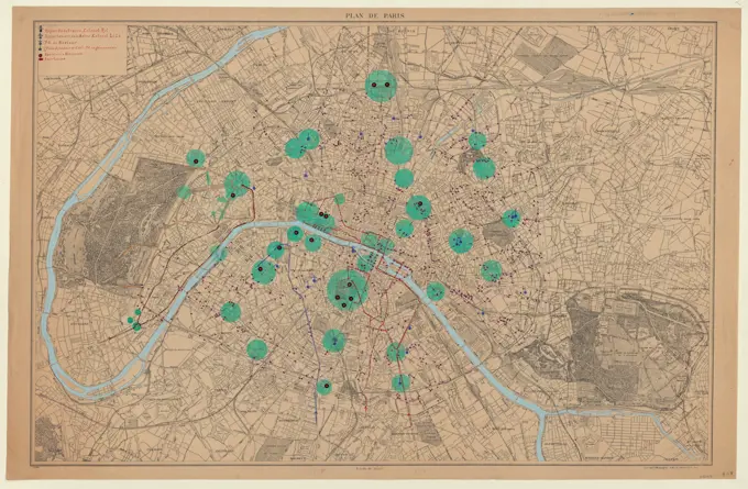
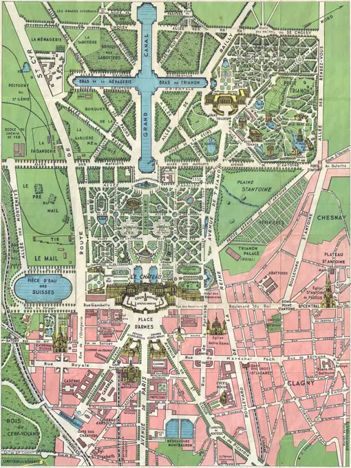
Historic City Maps of Europe

Digitally restored maps of European cities from the 19th century, showcasing historical layouts and landmarks in meticulous detail.
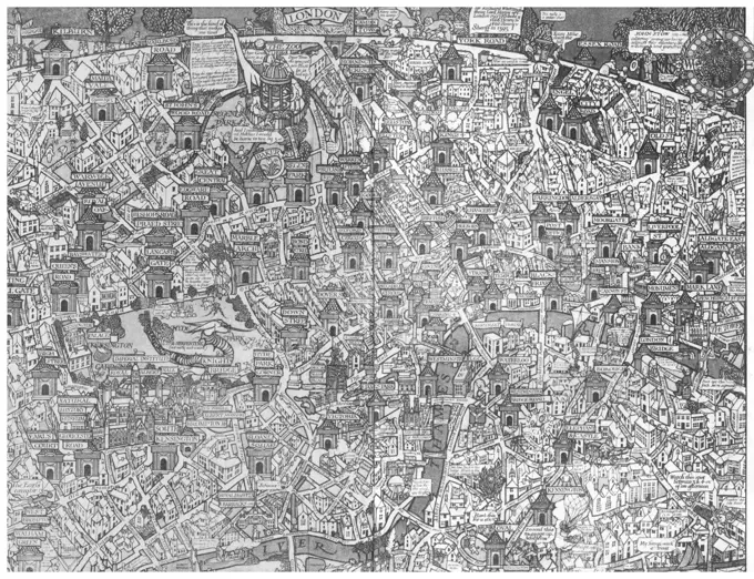
Map of the central business district city of Boston showing the location of underground conduits. Oriented with north to the upper right.... , Massachusetts  , Suffolk  ,county   , Boston
Map of the central business district city of Boston showing the location of underground conduits. Oriented with north to the upper right.... , Massachusetts , Suffolk ,county , Boston
Orth August (1828-1901), Stadtbahn project I, 1871, Stadtbahnproject II, 1872/73, Berlin (1871-1871): Plan content N.N. detected. Print colored, watercolor on paper, 64.6 x 80 cm (including scan edges)England, London, Street Map of the Thames Area between London Bridge and Tower BridgeMAPA DE MADRID Y ALREDEDORES 1969-DET EXTRARRADIO:VALLECAS(CONJ 71517). Location: INSTITUTO GEOGRAFICO Y CATASTRAL. MADRID. SPAIN.Baton Rouge , Louisiana, Maps, Baton Rouge La., Maps Norman B. Leventhal Map Center CollectionCollection Dutch Heidematschappij. Zieuwent, municipality Lichtenvoorde. Spread location soils belonging farm. undated. Lichtenvoorde, ZieuwentMap of London, showing the River Thames with numerous bridges, parks and major buildings.      Date: 1916Mother Brook recreation study , Open spaces, Massachusetts, Maps, Mother Brook Norfolk County and Suffolk County, Mass., Maps, Environmental engineering, Massachusetts, MapsPanoramic view of Boston showing golden semicircle , Massachusetts Route 128 Mass., Maps, Boston Mass., Maps, Boston Metropolitan Area Mass., Maps Norman B. Leventhal Map Center CollectionAnefo photo collection. Arms of robbery at the post office in Duivendrecht are displayed on the agency of the National Police in Amsterdam. October 31, 1966. Duivendrecht, Noord-HollandMap of the New York world's fair and approaches. 1939 - 1940. Cartographic. Maps. Lionel Pincus and Princess Firyal Map DivisionBoston over Time , Boston Mass., Historical geography, Maps, Boston Mass., History, Revolution, 1775-1783, Maps Norman B. Leventhal Map Center CollectionMap, gps and road of route, guide and navigation of city, street and landmark in app, website and online. Digital, location and direction for journey, info and travel for way, trip and help with iconBoston over Time. John Bonner and William Price's A new plan of ye great town of Boston in New England in America, superimposed over modern imagery provided by the Office of Geographic Information (MassGIS), Commonwealth of Massachusetts, MassIT. Map created by the Norman B. Leventhal Map Center for We Are One: Mapping the Road from Revolution to Independence.... , Massachusetts  , Suffolk  ,county   , BostonPLANO DE GRANADA (EL ALBAICIN). Location: PRIVATE COLLECTION. MADRID. SPAIN.Panoramic view of Boston showing golden semicircle. Shows industrial parks along Route 128, railroads, highways, proposed highways, airports, and shopping areas. Boston skyline illustrated pictorially. Key to industrial plants and text about Route 128 on verso. Verso page nos. 29 and 32... Route 128 Boston's golden semicircle offers these advantages. Route 128 Boston's golden semicircle offers these advantages, Massachusetts  , Suffolk  ,county   , BostonFingers pointing at outdoor city map, Boston, Massachusetts, USA.Arnauld Bro de Comeres director of Champagne Deutz showing the location of Champagne Deutz and Ay at Champagne Deutz in Ay, Vallee de la Marne, Champagne, Marne, Ardennes, FranceMetropolitan Transit Authority system route map , Local transit, Massachusetts, Boston, Maps, Boston Mass., Maps, Metropolitan Transit Authority Boston, Mass. Norman B. Leventhal Map Center CollectionNew York (N.Y.). Board of Estimate and Apportionment. Cartographic, Maps. 1916. Lionel Pincus and Princess Firyal Map Division. Zoning , New York (State) , New York, Maps Area District Map Section No. 13New York (N.Y.). Board of Estimate and Apportionment. Cartographic, Maps. 1916. Lionel Pincus and Princess Firyal Map Division. Zoning , New York (State) , New York, Maps Height District Map Section No. 17Paris plan. (Ti)MBTA map : 1977-1978 , Local transit, Massachusetts, Boston, Maps, Subways, Massachusetts, Boston, Maps, Bus rapid transit, Massachusetts, Boston, Maps, Boston Mass., Maps, Massachusetts Bay Transportation Authority Norman B. Leventhal Map Center CollectionCity Blueprints or Blueprint to Roads and Water System. City BlueprintsStreet roads map of the ESTANOVE NEIGHBOURHOOD, MONTPELLIERcartography, location and navigation concept - close up of map or city plan with pinSouthwest corridor restudy , Land use, Massachusetts, Boston, Maps, Southwest Corridor Boston, Mass., Maps, City planning, Massachusetts, Boston, Maps, Express highways, Massachusetts, Boston, MapsClose-up of a city mapAn illustrated map of Chicago : youthful city of the big shoulders, restless, ingenious, wilful, violent, proud to be alive!. Pictorial map. Relief shown pictorially. Indexed to points of interest. "Chicago U.S.A." in bottom margin. Oriented with north to the right... Chicago U.S.A. Illustrated map of Chicago : city of the big shoulders, proud to be alive. Chicago U.S.A. Illustrated map of Chicago : city of the big shoulders, proud to be alive, Illinois  , Cook  ,county   , ChicagoBoston's top 6 foreign languages spoken at home, 2010 , Language and languages, Maps, Linguistic demography, Massachusetts, Boston, Maps, Boston Mass., Maps Norman B. Leventhal Map Center CollectionFingers pointing at outdoor city map, Boston, Massachusetts, USAZollverein Coal Mine Industrial Complex, information board with a site map, Essen-Stoppenberg, Ruhr area, North Rhine-Westphalia, Germany, EuropeBerlin's old Tegel airport will soon be replaced in October (doubtful) by a new airport, Berlin-Brandenburg, located 19 km southeast of the city in Schönefeld. Construction began in 2006. But a mixture of design fiascos and other issues turned Berlin-Brandenburg into a national embarrassment as it missed six opening dates in succession. The main problems were 1) The original terminal design had to be redrawn with twice the capacity in an issue over the airport company adding airport shopping; 2) The construction planning company went bankrupt (Information courtesy of BBC News). The image was acquired June 13, 2020, covers an area of 25.8 by 30 km, and is located at 52.4 degrees north, 13.5 degrees east.Boston's top 6 foreign languages spoken at home, 2010. Source: 2006-2010 American Community Survey 5-year estimates. Shows tracts where 10% or more of adults speak at home Spanish, Vietnamese, Chinese, Portuguese, French Creole or Italian. Maps created for a 2014 exhibition at the Norman B. Leventhal Map Center at the Boston Public Library.. A single map compares the distribution of six major languages other than English spoken in individual households throughout the city. These languages are Spanish, Chinese, French (Haitian) Creole, Vietnamese, Portuguese, and Italian. For all of Boston, approximately 36% of the total population speaks a language other than English, compared to 26% in 1990. The highest percentages are found in East Boston (68.5%), Dorchester (41.6%) and Roslindale (40.6%). In Boston Public Schools, 47% of the students speak a language other than English as their first language, while English Language Learner students speak more than 85 different languages as their hoBoston city map & guide to the Freedom Trail & national historical park , Arts facilities, Massachusetts, Boston, Maps, Universities and colleges, Massachusetts, Boston, Maps, Historic sites, Massachusetts, Boston, Maps, Hotels, Massachusetts, Boston, Maps, Health facilities, Massachusetts, Boston, Maps, Parking, Massachusetts, Boston, Maps, Stadiums, Massachusetts, Boston, Maps, Transportation, Massachusetts, Boston, Maps, Freedom Trail Boston, Mass., Maps, Tourist mapsParcel 22 , Southwest Corridor Park Boston, Mass., Designs and plans, Roxbury Boston, Mass., Maps, City planning, Massachusetts, Boston, Maps Norman B. Leventhal Map Center CollectionInfographic of the city of Jerusalem; with details and principal enclaves. QuarkXPress (.qxp); Adobe InDesign (.indd); 5669x3661.This ground plan of Roman catacombs dates to 1897. These catacombs were originally quarries, some of which predate the founding of Rome (said to be 753 B.C.). They were said to be extended so that eventually all the seven hills of Roime were pierced by them. They are low dark corridors or vaulted halls excavated in the soft volcanic tufa and puzzolana, in the lateral walls of which apertures were made for the reception of corpses. In all there are some 40 Catacombs, each forming a network of galleries, usually intersection one another at right angles.The whole length of the Roman catacombs isMassachusetts official transportation map , Massachusetts, Maps, Roads, Massachusetts, Maps, Boston Mass., Maps, Worcester Mass., Maps, Springfield Mass., Maps Norman B. Leventhal Map Center CollectionAnonymous. Plan de Paris, the contemporary city. Ink, gouache and cork on agglomerated wood. Paris, Carnavalet museum. Geographical map, geography, contemporary period, plan of Paris, urban, contemporary city, 20th XX XX 20th 20th 20th 20th centuryArchitectural background with technical drawings. Blueprints series. Site plan texture. House blueprint, drawing, part of architectural project.. Architectural background with technical drawings. Blueprints plan texture. Drawing part of architectural project.Japan, Honshu, Tokyo, Ginza, Bi-lingual Street MapA map of the wondrous isle of Manhattan , Manhattan New York, N.Y., Maps, New York N.Y., Maps Norman B. Leventhal Map Center CollectionTennessee. New Mexico. Wyoming. Mississippi , Capitols, Tichnor Brothers Collection, postcards of the United StatesMarch 1939. Fighting continues in Madrid between Communists and Juntistas. In the Image, the center of Madrid, with the Puerta del Sol being marked with a 1.Illustrative site plan : Government Center urban renewal area, Massachusetts R-35 , Government Center Boston, Mass., Maps, Urban renewal, Massachusetts, Boston, Maps, City planning, Massachusetts, Boston, Maps, Land use, Massachusetts, Boston, Maps Norman B. Leventhal Map Center CollectionCafé de la Paix. 1955. Buttolph, Frank, 1850-1924. text. Menus. Rare Book DivisionBoston Over Time : filling in the land 1630 - present , Boston Mass., Historical geography, Maps Norman B. Leventhal Map Center CollectionEin allgemeiner Stadtplan mit Markierung A generic city map with marker Copyright: xZoonar.com/BorisxZerwannx 170464971920s Leconte Map of Paris w-Monuments and Map of VersaillesAtlas of underground quarries / land area exposed to a natural risk / Paris - Hauts-de-Seine - Seine-Saint-Denis - Val-de-Marne. / Fitting Table / Table published in 1970. Revised and reissued in 1976 and 1988Informationsschild Barden-Denkmal und Karte in der Festung Brest Belarus. Brest Brest Region Belarus 23. September 2020 Information sign bard memorial and map at the Brest Fortress in Leninskiy Rayon Brest Brest District Brest Region Belarus. LicenseRF Copyright: xZoonar.com/ArkadijxSchellx 23179080Metropolitan Transit Authority system route map , Local transit, Massachusetts, Boston, Maps, Boston Mass., Maps, Metropolitan Transit Authority Boston, Mass. Norman B. Leventhal Map Center CollectionBath City Information System, Bath, United Kingdom. Architect: Pearson Lloyd, 2011. Partial view of new map directory.Subway plan Manhattan, New York, USA, North AmericaMap of the U.S. strategic bombing campaign on Tokyo from November 29, 1944 - May 25, 1945. Effects of air attack on urban complex Tokyo-Kawasaki-Yokohama.Parcel 22 , Southwest Corridor Park Boston, Mass., Designs and plans, Roxbury Boston, Mass., Maps, City planning, Massachusetts, Boston, Maps Norman B. Leventhal Map Center CollectionMap of Utrecht with the tram road network of the G.E.T.U.New York (N.Y.). Board of Estimate and Apportionment. Cartographic, Maps. 1916. Lionel Pincus and Princess Firyal Map Division. Zoning , New York (State) , New York, Maps Area District Map Section No. 15Urban Street Map Plan Detailed street plan of an urban area, showcasing roads, avenues, and pathways. Suitable for city planning or geographic applications. Copyright: xolenadesignxWest end london map with pinBoston proper , Boston Mass., Aerial views Norman B. Leventhal Map Center CollectionMap, illustration and road of route, icon and navigation of city, street and landmark in app, website and online. Guide, location and direction for journey, info and travel for above and digitalPhysical and political map of Panama. Encapsulated Postscript File (.eps); 3507x2480.Infographic of the Greek city of Athens, with its main data and  enclaves. QuarkXPress (.qxp); Adobe InDesign (.indd); 5000x3229.Ein allgemeiner Stadtplan mit Symbolen A generic city map with icons Copyright: xZoonar.com/BorisxZerwannx 17046480City map, 1892, Smyrna, now Izmir, Turkey, digitally restored reproduction of an original 19th-century original, AsiaNew York (N.Y.). Board of Estimate and Apportionment. Cartographic, Maps. 1916. Lionel Pincus and Princess Firyal Map Division. Zoning , New York (State) , New York, Maps Area District Map Section No. 9Infographic of the city of Mumbai: location, population, foundation and places of interest. Adobe InDesign (.indd); 5669x3661.The colour of an old city : a map of Boston, decorative and historical , Boston Mass., History, Maps, Public buildings, Massachusetts, Boston, Maps, Central business districts, Massachusetts, Boston, Maps, Historic buildings, Massachusetts, Boston, Maps Norman B. Leventhal Map Center CollectionPhoto collection Government information service. 2 photos on 1 sheet. undated. The Hague, South HollandLetter made from dollar stacksAbsolute and Unprotected Auction Sale. 240 Exceptionally well-located lots belonging to the Estate of Martin Schenkeisen and to Geo. H. Huber text. Maps, Pamphlets. 1915-12-14. Lionel Pincus and Princess Firyal Map Division. Real property auctions , New York (State) , New YorkThe colour of an old city : a map of Boston, decorative and historical , Boston Mass., History, Maps, Public buildings, Massachusetts, Boston, Maps, Central business districts, Massachusetts, Boston, Maps, Historic buildings, Massachusetts, Boston, Maps Norman B. Leventhal Map Center CollectionStreet roads map of the LA CHEVILLOTTE COMMUNE, BESANCONMap of the density of bombing, London region, to October 1941 (HO193/45) Over the course of the Second World War, London was heavily bombed. This colour coded map was created by the Home Office in 1941, showing the amount of bombs that had fallen in the first year and a half since the bombing began in June 1940. The path of the Thames is clearly visible through the map, showing the highest intensity bombing around Central London and the docks. aerialbombing, worldwarii, wwii, theblitz, secondworldwar, bombingsurveyconverted PNM fileA map in the center of the town of Ampuis showing an overview of the Cote Rotie district. Ampuis, Cote Rotie, Rhone, France, EuropeAdvertising postcard for the Liverpool Street Hotel, bearing a map of the London Underground at the time of the Franco-British Exhibition of 1908.     Date: 1908A kite view of Philadelphia and the Sesqui Centennial International Exposition , Central business districts, Pennsylvania, Philadelphia, Maps, Philadelphia Pa., Maps, Philadelphia Pa., History, Maps, Sesqui-Centennial International Exposition 1926 : Philadelphia, Pa. Norman B. Leventhal Map Center CollectionT system map , Local transit, Massachusetts, Boston, Maps, Subways, Massachusetts, Boston, Maps, Bus rapid transit, Massachusetts, Boston, Maps, Boston Mass., Maps, Massachusetts Bay Transportation Authority Norman B. Leventhal Map Center CollectionMetrowest Knox Trail heritage corridor : including visitor attractions, historical sites, and cultural opportunitiesA city of unequal risks , Boston Mass., Maps, Climatic changes, Social aspects, Massachusetts, Boston, Maps, Disasters, Social aspects, Massachusetts, Boston, Maps, Floods, Massachusetts, Boston, Maps, Urban heat island, Massachusetts, Boston, Maps, Open spaces, Massachusetts, Boston, Maps Norman B. Leventhal Map Center CollectionT system map , Local transit, Massachusetts, Boston, Maps, Subways, Massachusetts, Boston, Maps, Bus rapid transit, Massachusetts, Boston, Maps, Boston Mass., Maps, Massachusetts Bay Transportation Authority Norman B. Leventhal Map Center CollectionBath City Information System, Bath, United Kingdom. Architect: Pearson Lloyd, 2011. Partial view of new map directory.27 08 2024, Switzerland, Bern, Society, A Drawing on a Sidewalk Indicates for all on 14 9 24, Day of Citizens Communities, SwitzerlandClose-up of navigational system and mapA map being held in man's hands with woman beside011040109-North Dakota Flooding   Map of Fargo with pumping stat. North Dakota Severe Storms and Flooding. Photographs Relating to Disasters and Emergency Management Programs, Activities, and OfficialsBoston's diversity index, 2010 : measures of diversity : education.. Another series of maps produced by the Boston Redevelopment Authority shows different measures of diversity, including race, language, age, household income, education, and region of birth. Census tracts on each map range in color from deep orange (indicating the most diverse neighborhoods) to deep green (least diverse). By comparing these various maps, it is evident that the most diverse census tracts are located in Dorchester, Roxbury, Roslindale, East Boston, and Brighton... , Massachusetts  , Suffolk  ,county   , BostonBath City Information System, Bath, United Kingdom. Architect: Pearson Lloyd, 2011. Partial view of new map directory.Close-up of a subway map, Moscow, RussiaEngland, London, City of London, Street Map of The Bank of England and Guildhall AreaJapan, Honshu, Tokyo, Ginza, Bi-lingual Street MapMap of the medina at the gateway into Bab el Fahs, Old Medina, Tangier, Morocco, Africa. (Editorial Use Only)Aerial View 02CANADA, NUNAVUT, CAPE DORSET, PRINT CO-OP, ARTIST MARY PUDLAP WORKING ON DRAWINGBoston's diversity index, 2010 : measures of diversity : age , Boston Mass., Maps, Age distribution Demography, Massachusetts, Boston, Maps Norman B. Leventhal Map Center CollectionSign showing the layout of Auschwitz-Birkenauconcentration camp, PolandPharus Map of World's Fair St. Louis, Missouri 1904.Grand Rounds Scenic Byway - Layout of an Aerial Photo Panel. The layout of this aerial photo panel allows travelers to easily read directions. Minnesota (44.912° N 93.243° W)