Historic Insurance Maps of Boston & NYC

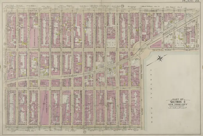
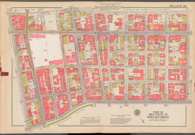
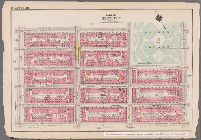
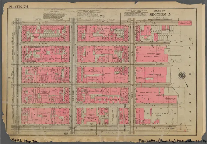
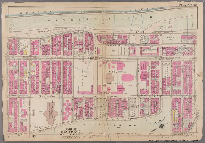
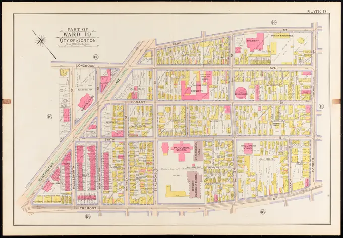
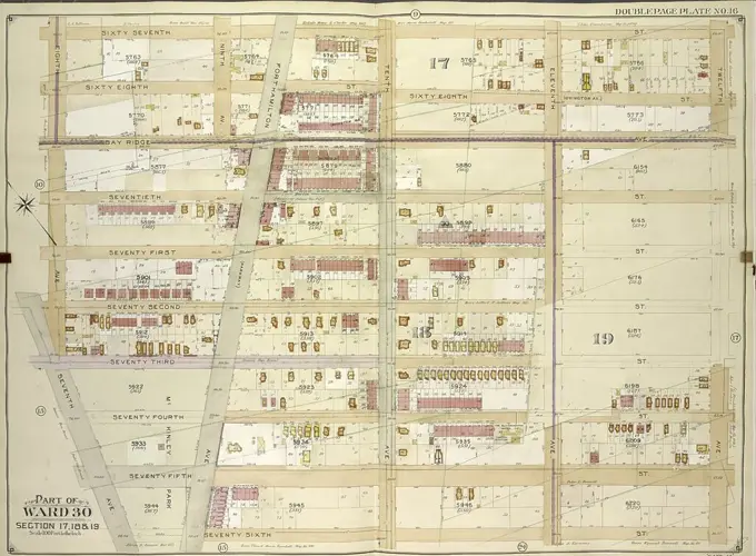
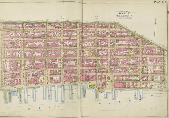
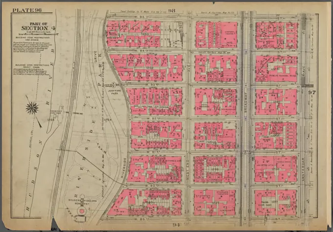
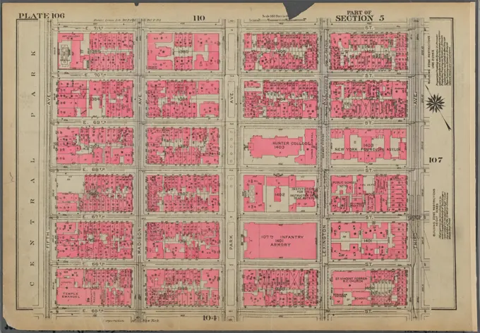
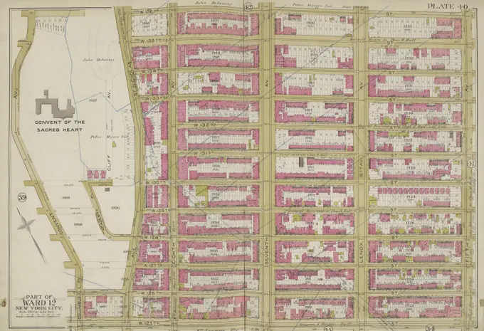
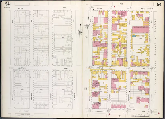
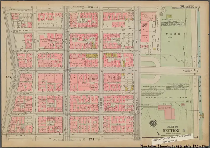
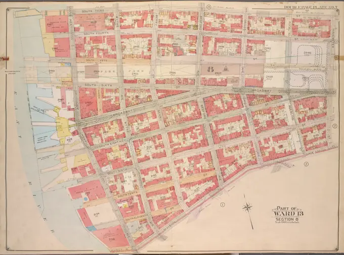
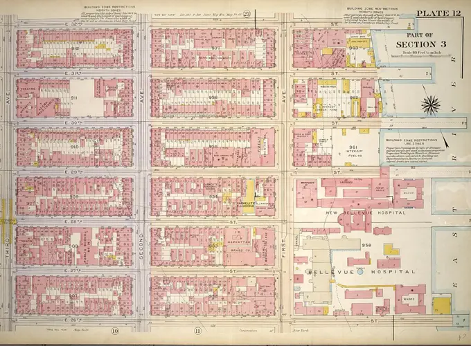
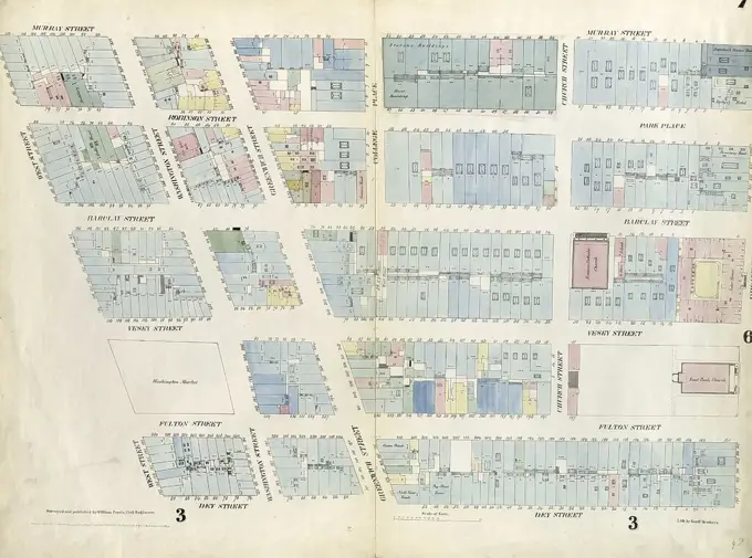
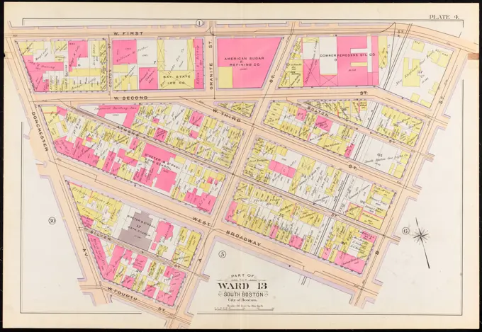
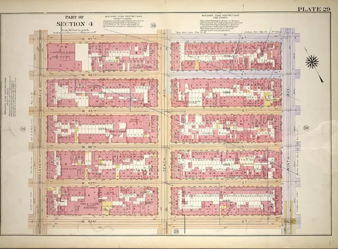
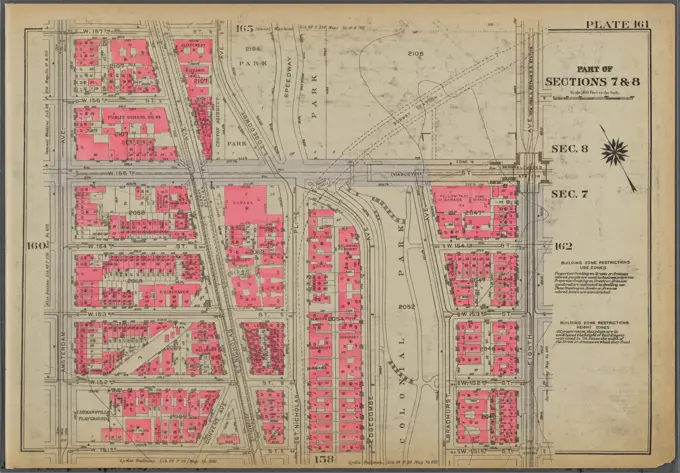
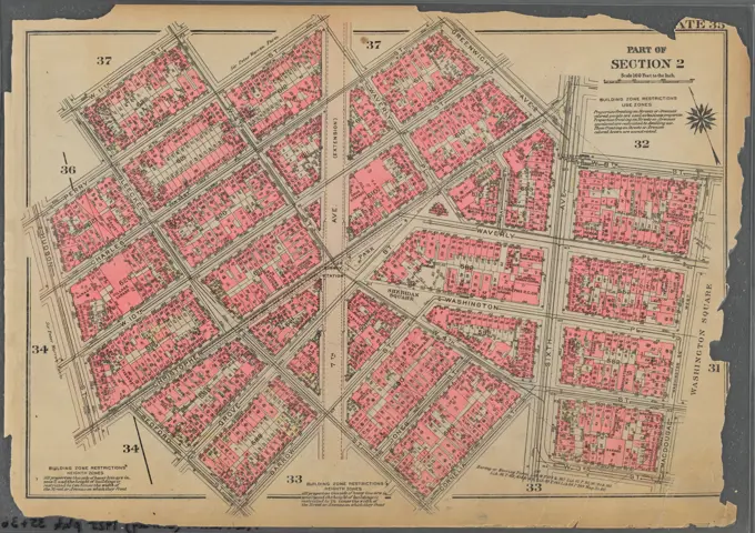
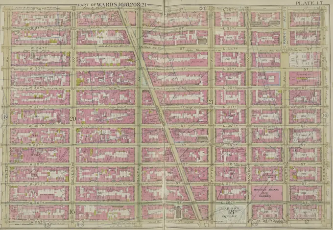
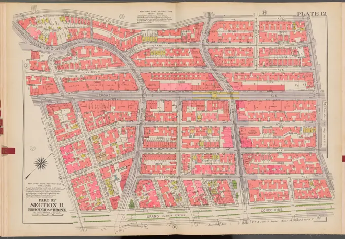
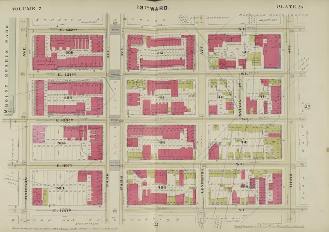
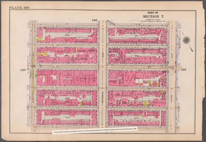
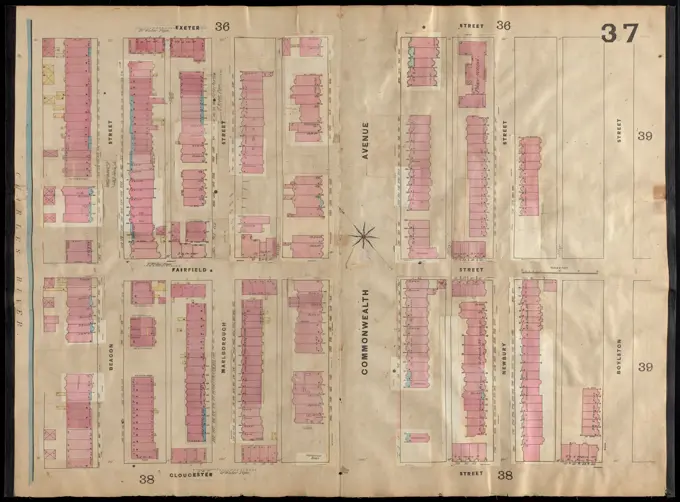
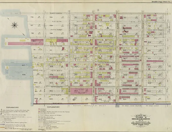
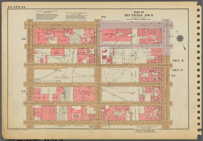
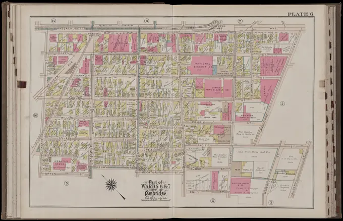
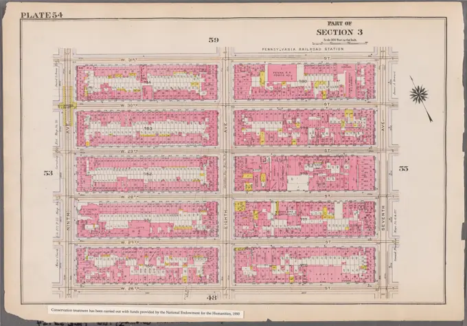
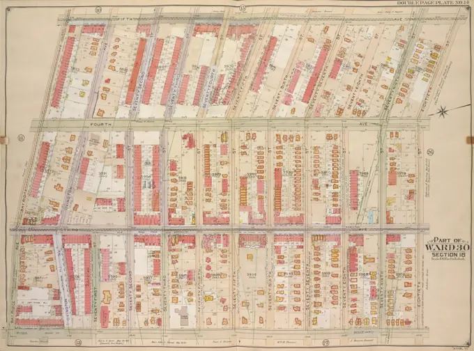
Detailed, hand-colored maps depicting fire risk assessments and real estate layouts from Boston and New York, showcasing urban structures and street layouts.

Plate 23 Bounded by Ninth Avenue, W. 64th Street, Central Park West, Central Park South, Sixth Avenue, and W. 47th Street. Additional, Part of Section 3, New York City., 1897., Philadelphia. Publisher, G.W. Bromley & Co. Real property, New York (State), New York, Manhattan (New York, N.Y.)
Cartographic, Maps. 1921 - 1923. Lionel Pincus and Princess Firyal Map Division. Real property , New York (State) , New York, Manhattan (New York, N.Y.) Plate 125: Bounded by E. 110th Street, Pleasant Avenue, Harlem River, E. 105th Street and Third AvenueCartographic, Maps. 1938 - 1957. Lionel Pincus and Princess Firyal Map Division. Real property , New York (State) , New York (N.Y.), Bronx (New York, N.Y.) , Maps Double Page Plate No. 10, Part of Section 11, Borough of the Bronx: Bounded by E. 181st Street, Mapes Avenue, E. Tremont Avenue and Bathgate AvenueCartographic, Maps. 1955 - 1956. Lionel Pincus and Princess Firyal Map Division. Real property , New York (State) , New York (N.Y.), Manhattan (New York, N.Y.) Plate 134, Part of Section 7: Bounded by W. 122nd Street, Lenox Avenue, W. 116th Street and Eighth Avenue.Manhattan, Double Page Plate No. 8 Map bounded by W. 3rd St., E. 3rd St., Essex Ave., Broome St., S. 5th Ave..Cartographic, Maps. 1916. Lionel Pincus and Princess Firyal Map Division. Atlases, Manhattan (New York, N.Y.), Real property , New York (State) , New York Plate 28: Bounded by E. 9th Street, E. Avenue A, E. 7th Street, Avenue B, East 4th Street, and Second Avenue Part of Section 2Cartographic, Maps. 1930. Lionel Pincus and Princess Firyal Map Division. Real property , New York (State) , New York, Manhattan (New York, N.Y.) Plate 74, Part of Section 5: Bounded by E. 47th Street, (East River Piers) First Avenue, E. 42nd Street and Third AvenueE.B. Hyde & Co.. Cartographic, Maps. 1906. Lionel Pincus and Princess Firyal Map Division. Brooklyn (New York, N.Y.) , Maps, Real property , New York (State) , New York Brooklyn, Vol. 5, Double Page Plate No. 19; Part of Ward 29, 30, 31 & 32, Section 16; Map bounded by E. 21st St., Kenmore Pl., Avenue G, Argyle Road; Including Dorchester Road, E. 19th St., Ditmas Ave.Cartographic, Maps. 1911. Lionel Pincus and Princess Firyal Map Division. New York (N.Y.), Manhattan (New York, N.Y.), Real property , New York (State) , New York , Manhattan Plate 38: Bounded by Hudson River (Riverside Park, Riverside Drive), W. 125th Street, Morningside Drive, Columbus Avenue, and W. 108th Street. Part of Section 7, New York City.Plate 28, Part of Sections 3&4: Bounded by W. 42nd Street, Ninth Avenue, W. 37th Street and Eleventh Avenue.Atlas of the city of Boston : city proper : plate 60 , Boston Mass., Maps, Real property, Massachusetts, Boston, Maps, Landowners, Massachusetts, Boston, Maps, South End Boston, Mass., Maps Norman B. Leventhal Map Center CollectionE.B. Hyde & Co.. Cartographic, Maps. 1904 - 1912. Lionel Pincus and Princess Firyal Map Division. Brooklyn (New York, N.Y.) , Maps, Real property , New York (State) , New York Brooklyn, Vol. 2, Double Page Plate No. 10; Part of Wards 7 & 21, Sections 6 & 7; Map bounded by Flushing Ave., Marcy Ave.; Including Willoughby Ave., Kent Ave.Cartographic, Maps. 1911. Lionel Pincus and Princess Firyal Map Division. Bronx (New York, N.Y.), New York (N.Y.) Plate 28 Map bounded by Southern Blvd., E. 163rd St., Stebbins Ave., Hall Pl., Home St.Cartographic, Maps. 1925. Lionel Pincus and Princess Firyal Map Division. Real property , New York (State) , New York, Manhattan (New York, N.Y.) Plate 53, Part of Section 3: Bounded by W. 32nd Street, Ninth Avenue, W. 26th Street and Eleventh AvenueAtlas of the city of Boston, Roxbury : plate 17 , Boston Mass., Maps, Real property, Massachusetts, Boston, Maps, Landowners, Massachusetts, Boston, Maps, Fenway Boston, Mass., Maps Norman B. Leventhal Map Center CollectionCartographic, Maps. 1955 - 1956. Lionel Pincus and Princess Firyal Map Division. Real property , New York (State) , New York (N.Y.), Manhattan (New York, N.Y.) Plate 106, Part of Section 5: Bounded by E. 71st Street, Third Avenue, E. 65th Street and (Central Park) Fifth Avenue.Cartographic, Maps. 1930. Lionel Pincus and Princess Firyal Map Division. Real property , New York (State) , New York, Manhattan (New York, N.Y.) Plate 1, Part of Section 1: Bounded by Beaver Street, Broad Street, Exchange Place, William Street, Cedar Street, Pearl Street, Pine Street, South Street, Whitehall Street and State StreetBrooklyn, Vol. 6, Double Page Plate No. 16; Part of Ward 30, Sections 17, 18 & 19; Map bounded by 67th St., 12th Ave., 76th St.; Including 7th Ave., 8th Ave.Brooklyn, Vol. 5, Double Page Plate No. 25; Part of Ward 29, Section 16; Map bounded by Argyle Road, Cortelyou Road, Ocean Parkway; Including Church Lane, Albemarle Road.Insurance map of Charlestown : portions of Roxbury (now annexed to Boston) and Cambridge : 1868 : corrected Nov. 1871 : plate 12 , Fire risk assessment, Massachusetts, Cambridge, Maps, Real property, Massachusetts, Cambridge, Maps, Cambridge Mass., Maps Norman B. Leventhal Map Center CollectionPlate 31, Part of Sections 4&5: Bounded by W. 47th Street, Fifth Avenue, W. 42nd Street and Seventh Avenue.Manhattan, Double Page Plate No. 6 Map bounded by Division St., Grand St., Corlears St., East River, Market St..Cartographic, Maps. 1930. Lionel Pincus and Princess Firyal Map Division. Real property , New York (State) , New York, Manhattan (New York, N.Y.) Plate 96, Part of Section 4: Bounded by W. 95th Street, Amsterdam Avenue, W. 89th Street and (Hudson River, Riverside Park) Riverside DriveCartographic, Maps. 1925. Lionel Pincus and Princess Firyal Map Division. Real property , New York (State) , New York, Manhattan (New York, N.Y.) Plate 62, Part of Section 3: Bounded by E. 37th Street, (East River Piers) First Avenue, E. 32nd Street and Third AvenueCartographic, Maps. 1899. Lionel Pincus and Princess Firyal Map Division. Manhattan (New York, N.Y.), Real property , New York (State) , New York Plate 20, Part of Section 2: Bounded by Prince Street, Marion Street, Centre Street, Grand Street and Sullivan StreetPlate 31, Part of Sections 4&5: Bounded by W. 47th Street, Fifth Avenue, W. 42nd Street and Seventh Avenue.Cartographic, Maps. 1897. Lionel Pincus and Princess Firyal Map Division. Real property , New York (State) , New York, Manhattan (New York, N.Y.) Plate 33:Bounded by Third Avenue, E. 125th Street, East River (Pleasant Avenue) and E. 108th Street. Part of Section 6, New York City.Bromley, George Washington. Cartographic, Maps, Atlases, land surveys. 1908. Lionel Pincus and Princess Firyal Map Division. Brooklyn (New York, N.Y.) , Maps Plate 4: Bounded by Atlantic Avenue, Bond Street, Schermerhorn Street, Flatbush Avenue, Fifth Avenue, President Street and Court Street Plate 4Cartographic, Maps. 1930. Lionel Pincus and Princess Firyal Map Division. Real property , New York (State) , New York, Manhattan (New York, N.Y.) Plate 106, Part of Section 5: Bounded by E. 71st Street, Third Avenue, E. 65th Street and (Central Park) Fifth AvenuePlate 7, Part of Section 1: Bounded by New Bowery Street, East Broadway, Pike Street, Pike Slip, South Street, and New Street.Newark, V. 1, Double Page Plate No. 2 Map bounded by Warren St., W. Park St., Broad St., Market St., Springfield Ave., S. Orange Ave., Howard St., Henry St., Colden St. Cartographic. Atlases, Maps. 1911-12. Lionel Pincus and Princess Firyal Map Division. Newark (N.J.)Insurance maps of Boston volume two : plate 29 , Fire risk assessment, Massachusetts, Boston, Maps, South End Boston, Mass., Maps Norman B. Leventhal Map Center CollectionCartographic, Maps. 1921 - 1923. Lionel Pincus and Princess Firyal Map Division. Real property , New York (State) , New York, Manhattan (New York, N.Y.) Plate 66: Bounded by W. 42nd Street, Fifth Avenue, W. 37th Street and Seventh AvenueCartographic, Maps. 1925. Lionel Pincus and Princess Firyal Map Division. Real property , New York (State) , New York, Manhattan (New York, N.Y.) Plate 5, Part of Section 1: Bounded by Reade Street, Broadway, Vesey Street and (Hudson River Piers) West StreetPlate 40 Map bounded by W. 136th St., 5th Ave., W. 125th St., Convent Ave., issued in 1891 by G.W. Bromley & Co., Philadelphia, Publisher, G.W. Bromley & Co., Manhattan (New York, N.Y.), Real property, New York (State), New YorkCartographic, Maps. 1884 - 1936. Lionel Pincus and Princess Firyal Map Division. Fire insurance , New York (State), Real property , New York (State), Cities & towns , New York (State) Brooklyn V. 2, Plate No. 54 Map bounded by Grand Ave., Park Ave., Classon Ave., Willoughby Ave.Cartographic, Maps. 1925. Lionel Pincus and Princess Firyal Map Division. Real property , New York (State) , New York, Manhattan (New York, N.Y.) Plate 173, Part of Section 8: Bounded by W. 184th Street, Laurel Hill Terrace, (Highbridge Park, Harlem River) Amsterdam Avenue, W. 178th Street and BroadwayPlate 23, Part of Section 3: Bounded by E. 37th Street, First Avenue, E. 32nd Street and Third Avenue.Cartographic, Maps. 1927. Lionel Pincus and Princess Firyal Map Division. Real property , New York (State) , New York, Manhattan (New York, N.Y.) Plate 163, Part of Section 8: Bounded by W. 163rd Street, Broadway, W. 157th Street and (Hudson River, Fort Washington Park) Riverside DrivePlate 33, Part of Section 5: Bounded by E. 47th Street,East River Piers, First Avenue, E. 42nd Street and Third Avenue.Cartographic, Maps. 1955 - 1956. Lionel Pincus and Princess Firyal Map Division. Real property , New York (State) , New York (N.Y.), Manhattan (New York, N.Y.) Plate 22, Part of Section 2: Bounded by W. 3rd Street, Broadway, E. Houston Street, Crosby Street, Prince Street, Macdougal Street, W. Houston Street and Sullivan Street.Plate 2, Part of Section 3: Bounded by E. 20th Street, Avenue B, E. 14th Street and Second Avenue.Part of Sections 5 & 6 : New York City.E.B. Hyde & Co.. Cartographic, Maps. 1904 - 1912. Lionel Pincus and Princess Firyal Map Division. Brooklyn (New York, N.Y.) , Maps, Real property , New York (State) , New York Brooklyn, Vol. 3, Double Page Plate No. 7; Part of Ward 13, Section 8; Map bounded by South Third St., Haveneyer St.; Including Division Ave., East RiverCartographic, Maps. 1889. Lionel Pincus and Princess Firyal Map Division. Real property , New York (State) , New York, New York (N.Y.) Plate 32 Map bounded by E. 94th St., Avenue A, E. 90th St., 2nd Ave.Plate 12, Part of Section 3: Bounded by E. 32nd Street, East River Piers First Avenue, E. 26th Street and Third Avenue.Atlas of the city of Boston, Boston proper and Back Bay : plate 28 , Boston Mass., Maps, Real property, Massachusetts, Boston, Maps, Landowners, Massachusetts, Boston, Maps, South End Boston, Mass., Maps Norman B. Leventhal Map Center CollectionInsurance maps of Boston volume two : plate 37 , Fire risk assessment, Massachusetts, Boston, Maps, Back Bay Boston, Mass., Maps Norman B. Leventhal Map Center CollectionCartographic, Maps. 1891. Lionel Pincus and Princess Firyal Map Division. Manhattan (New York, N.Y.), Real property , New York (State) , New York Plate 15 Map bounded by E. 25th St., East River, E. 14th St., 2nd Ave.Plate 10, Part of Section 4: Bounded by W. 89th Street, Amsterdam Avenue, W. 83rd Street and Riverside Park Riverside Drive.Plate 7: Map bounded by Murray Street, Broadway, Dey Street, West Street. 1857, 1862, Perris and Browne, New York, USA.Brooklyn, Vol. 2, Double Page Plate No. 21; Part of Wards 24 & 26, Section 5; Map bounded by Atlantic Ave., Rockaway Ave., East New York Ave.; IncludingSt. Johns PL. Douglass St., Ralph Ave.Plate 39, Part of Section 4: Bounded by Twelfth Avenue Hudson River Piers,W. 50th Street, Eleventh Avenue and W. 41st Street.Plate 3: Part of Wards 1, 3, 4, & 6. City of Brooklyn.Atlas of the city of Boston, South Boston : plate 4 , Boston Mass., Maps, Real property, Massachusetts, Boston, Maps, Landowners, Massachusetts, Boston, Maps Norman B. Leventhal Map Center CollectionCartographic, Maps. 1930. Lionel Pincus and Princess Firyal Map Division. Real property , New York (State) , New York, Manhattan (New York, N.Y.) Plate 35, Part of Section 2: Bounded by W. 11th Street, W. 4th Street, Perry Street, Waverly Place, Charles Street, Greenwich Avenue, Sixth Avenue, W. 8th Street, Macdougal Street, W. 3rd Street, Sixth Avenue, Cornelia Street, Bleecker Street, Barrow Street, Bedford Street, Christopher Street, Hudson Street, Perry Street and Bleecker StreetCartographic, Maps. 1891. Lionel Pincus and Princess Firyal Map Division. Fire insurance , New York (State), Real property , New York (State), Cities & towns , New York (State) Bronx, V. 9, Double Page Plate No. 208 Map bounded by East 156th St., Melrose Ave., East 151st St., Railroad Ave. East.Cartographic, Maps. 1930. Lionel Pincus and Princess Firyal Map Division. Real property , New York (State) , New York, Manhattan (New York, N.Y.) Plate 49, Part of Section 3: Bounded by W. 26th Street, E. 26th Street, Madison Avenue, W. 23rd Street, Broadway, E. 20th Street, W. 20th Street and Seventh AvenuePlate 29, Part of Section 4: Bounded by W. 47th Street, Ninth Avenue, W. 42nd Street and Eleventh Avenue.Plate 35, Part of Sections 5&6: Bounded by E. 100th Street, Third Avenue, E. 95th Street and Central Park Fifth Avenue.Cartographic, Maps. 1891. Lionel Pincus and Princess Firyal Map Division. Manhattan (New York, N.Y.), Real property , New York (State) , New York Plate 16 Map bounded by Lexington Ave., E. 40th St., East River, E. 25th St.Cartographic, Maps. 1930. Lionel Pincus and Princess Firyal Map Division. Real property , New York (State) , New York, Manhattan (New York, N.Y.) Plate 161, Part of Sections 7 & 8: Bounded by W. 157th Street, Eighth Avenue, W. 151st Street and Amsterdam AvenueCartographic, Maps. 1921 - 1923. Lionel Pincus and Princess Firyal Map Division. Real property , New York (State) , New York, Manhattan (New York, N.Y.) Plate 96: Bounded by W. 95th Street, Amsterdam Avenue, W. 89th Street and (Hudson River, Riverside Park) Riverside DriveCartographic, Maps. 1955 - 1956. Lionel Pincus and Princess Firyal Map Division. Real property , New York (State) , New York (N.Y.), Manhattan (New York, N.Y.) Plate 96, Part of Section 4: Bounded by W. 95th Street, Amsterdam Avenue, W. 89th Street and (Hudson River, Riverside Park) Riverside Drive.Cartographic, Maps. 1925. Lionel Pincus and Princess Firyal Map Division. Real property , New York (State) , New York, Manhattan (New York, N.Y.) Plate 35, Part of Section 2: Bounded by W. 11th Street, W. 4th Street, Perry Street, Waverly Place, Charles Street, Greenwich Avenue, Sixth Avenue, W. 8th Street, MacDougal Street, W. 3rd Street, Sixth Avenue, Cornelia Street, Bleecker Street, Barrow Street, Bedford Street, Christopher Street, Hudson Street, Perry Street and Bleecker StreetPlate 17 Map bounded by E. 36th St., Lexington Ave., W. 25th St., 8th Ave., issued in 1891 by G.W. Bromley & Co., showing real property in Manhattan, New YorkCartographic, Maps. 1938 - 1957. Lionel Pincus and Princess Firyal Map Division. Real property , New York (State) , New York (N.Y.), Bronx (New York, N.Y.) , Maps Double Page Plate No. 12, Part of Section 11, Borough of the Bronx: Bounded by Harrison Avenue, W. 181st Street, E. 181st Street, Grand Concourse, Mt. Hope Place, Jerome Avenue, W. 177th Street and W. Tremont AvenueAtlas of the city of Boston, East Boston : plate 7 , Boston Mass., Maps, Real property, Massachusetts, Boston, Maps, Landowners, Massachusetts, Boston, Maps, East Boston Boston, Mass., Maps Norman B. Leventhal Map Center CollectionPlate 26 Map bounded by E. 122nd St., 3rd Ave., E. 118th St., Madison Ave., issued in 1890 by E. Robinson Co. New York, Publisher, E. Robinson Co. Real property, New York (State), New York, New York (N.Y.)Atlas of the city of Boston, volume eight, South Boston, Mass. : from actual surveys and official plans. plate 19 , Real property, Massachusetts, Boston, Maps, Landowners, Massachusetts, Boston, Maps, South Boston Boston, Mass., Maps Norman B. Leventhal Map Center CollectionCartographic, Maps. 1921 - 1923. Lionel Pincus and Princess Firyal Map Division. Real property , New York (State) , New York, Manhattan (New York, N.Y.) Plate 138: Bounded by Tiemann Place, W. 125th Street, Amsterdam Avenue, W. 122nd Street and (Hudson River, Riverside Park) Riverside DriveCartographic, Maps. 1916. Lionel Pincus and Princess Firyal Map Division. Atlases, Manhattan (New York, N.Y.), Real property , New York (State) , New York Plate 140: Bounded by W. 127th Street, Lenox Avenue, W. 122nd Street and Eighth Avenue Part of Section 7Insurance maps of Boston volume 4 : comprising portions of Charlestown, East Cambridge, Cambridge Port, Old Cambridge & Somerville : plate 96 , Fire risk assessment, Massachusetts, Cambridge, Maps, Cambridge Mass., Maps Norman B. Leventhal Map Center CollectionPlate 159: Bounded by W. 151st Street, Seventh Avenue, W. 150th Street, Harlem River Lenox Avenue, W. 145th Street andEighth Avenue.Cartographic, Maps. 1927. Lionel Pincus and Princess Firyal Map Division. Real property , New York (State) , New York, Manhattan (New York, N.Y.) Plate 116, Part of Section 5: Bounded by York Avenue, E. 85th Street, East End Avenue, E. 79th Street, (East River) Exterior Street and E. 76th StreetInsurance maps of Boston volume two : plate 37 , Fire risk assessment, Massachusetts, Boston, Maps, Back Bay Boston, Mass., Maps Norman B. Leventhal Map Center CollectionPlate 21: Map bounded by Houston Street, Crosby Street, Broome Street, Broadway, Spring street, Sullivan Street. 1857, 1862, Perris and Browne, New York, USA.Hudson County, V. 1, Double Page Plate No. 3 Map bounded by Jersey Ave., 11th St., Provost St., 2nd St. Cartographic. Atlases, Maps. 1908 - 1909. Lionel Pincus and Princess Firyal Map Division. Jersey City (N.J.), Hudson County (N.J.)Part of Ward 8. Land Map Section, No. 3, Volume 1, Brooklyn Borough, New York City.Cartographic, Maps. 1921 - 1923. Lionel Pincus and Princess Firyal Map Division. Real property , New York (State) , New York, Manhattan (New York, N.Y.) Plate 109: Bounded by Avenue A, E. 76th Street, (East River) Exterior Street and E. 67th StreetPlate 6, Part of Section 4: Bounded by W. 77th Street, Amsterdam Avenue, W. 71st Street, West End Avenue, W. 72nd Street and Riverside Drive.Cartographic, Maps. 1955 - 1956. Lionel Pincus and Princess Firyal Map Division. Real property , New York (State) , New York (N.Y.), Manhattan (New York, N.Y.) Plate 169, Part of Section 8: Bounded by W. 173rd Street, (Highbridge Park, Harlem River) Amsterdam Avenue, Edgecombe Avenue, W. 167th Street, St. Nicholas Avenue and Broadway.Cartographic, Maps. 1930. Lionel Pincus and Princess Firyal Map Division. Real property , New York (State) , New York, Manhattan (New York, N.Y.) Plate 20, Part of Section 2: Bounded by Prince Street, Cleveland Street, Centre Street, Grand Street and Sullivan StreetCartographic, Maps. 1955 - 1956. Lionel Pincus and Princess Firyal Map Division. Real property , New York (State) , New York (N.Y.), Manhattan (New York, N.Y.) Plate 64, Part of Sections 3 & 4: Bounded by W. 42nd Street, Ninth Avenue, W. 37th Street and Eleventh Avenue.Cartographic, Maps. 1916. Lionel Pincus and Princess Firyal Map Division. Atlases, Manhattan (New York, N.Y.), Real property , New York (State) , New York Plate 164: Bounded by W. 162nd Street, Amsterdam Avenue, W. 157th Street and Broadway Part of Section 8Cartographic, Maps. 1920. Lionel Pincus and Princess Firyal Map Division. Manhattan (New York, N.Y.), Real property , New York (State) , New York, New York (N.Y.) Plate 19, Part of Section 3: Bounded by W. 37th Street, Ninth Avenue, W. 32nd Street and Eleventh Avenue.Atlas of the city of Cambridge, Massachusetts : from actual surveys and official plans. plate 6 , Real property, Massachusetts, Cambridge, Maps, Landowners, Massachusetts, Cambridge, Maps, Cambridge Mass., Maps Norman B. Leventhal Map Center CollectionE.B. Hyde & Co.. Cartographic, Maps. 1916. Lionel Pincus and Princess Firyal Map Division. Brooklyn (New York, N.Y.), Real property , New York (State) , New York Brooklyn, Vol. 1, 2nd Part, Double Page Plate No. 39; Part of Wards 27 & 28, Section 11; Map bounded by De Kalb Ave., Stockholm St., Stanhope St., Himrod St., Harman St., Greene Ave., Bleeker St., Menahan St.; Including Grove St., Linden St., Gates Ave., Palmetto St., Myrtle Ave., Wyckoff Ave., Cornelia St., BroadwayPlate 24, Part of Sections 3&5: Bounded by E. 42nd Street, East River Piers First Avenue, E. 37th Street and Third Avenue.Cartographic, Maps. 1895. Lionel Pincus and Princess Firyal Map Division. Fire insurance , New York (State), Real property , New York (State), Cities & towns , New York (State) Manhattan, V. 3, Double Page Plate No. 50 Map bounded by W. 4th St., Greene St., W. Houston St., Hancock St., Minetta St., 6th Ave.Brooklyn, Vol. 2, Double Page Plate No. 11; Part of Ward 21, Section 6; Map bounded by Flushing Ave., Broadway, Lewis Ave.; IncludingHart St., Marcy Ave.Part of Sections 6 & 7 : New York City.Hudson County, V. 2, Double Page Plate No. 2 Map bounded by Adams St., 4th St., Washington St., Ferry St. Cartographic. Atlases, Maps. 1908 - 1909. Lionel Pincus and Princess Firyal Map Division. Jersey City (N.J.), Hudson County (N.J.)Cartographic, Maps. 1916. Lionel Pincus and Princess Firyal Map Division. Atlases, Manhattan (New York, N.Y.), Real property , New York (State) , New York Plate 70: Bounded by W. 47th Street, Ninth Avenue, W. 42nd Street, and Eleventh Avenue Part of Section 4Plate 6, Part of Section 3: Bounded by W. 20th Street, Ninth Avenue, W. 14th Street, Hudson River Docks Eleventh Ave.Cartographic, Maps. 1890. Lionel Pincus and Princess Firyal Map Division. Real property , New York (State) , New York, New York (N.Y.) Plate 27 Map bounded by E. 126th St., 3rd Ave., E. 122nd St., Madison Ave.Cartographic, Maps. 1891. Lionel Pincus and Princess Firyal Map Division. Manhattan (New York, N.Y.), Real property , New York (State) , New York Plate 11 Map bounded by E. 14th St., 1st Ave., W. 3rd St., 6th Ave.Plate 25, Part of Sections 3&5: Bounded by E. 42nd Street, Third Avenue, E. 37th Street and Fifth Avenue.Cartographic, Maps. 1916. Lionel Pincus and Princess Firyal Map Division. Atlases, Manhattan (New York, N.Y.), Real property , New York (State) , New York Plate 54: Bounded by W. 31st Street, Seventh Avenue, W. 26th Street, and Ninth Avenue Part of Section 3E.B. Hyde & Co.. Cartographic, Maps. 1905. Lionel Pincus and Princess Firyal Map Division. Brooklyn (New York, N.Y.) , Maps, Real property , New York (State) , New York Brooklyn, Vol. 6, Double Page Plate No. 14; Part of Ward 30, Section 18; Map bounded by 5th Ave., 18th St.; Including Ridge Blvd., Bay Ridge Ave.E.B. Hyde & Co.. Cartographic, Maps. 1904 - 1912. Lionel Pincus and Princess Firyal Map Division. Brooklyn (New York, N.Y.) , Maps, Real property , New York (State) , New York Brooklyn, Vol. 3, Double Page Plate No. 9; Part of Wards 14 & 17, Sections 8 & 9; Map bounded by North Fourteenth St., Driggs Ave., North Fifth St., Including East River, Bushwick Greek