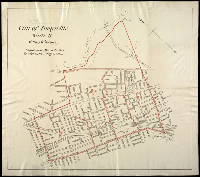
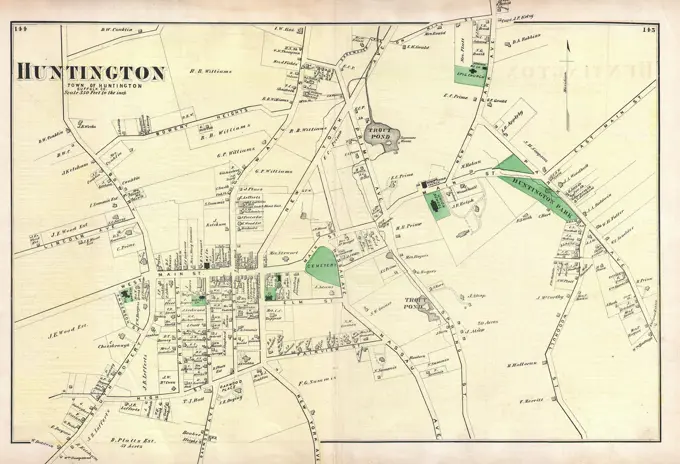
Historical City Maps of Boston

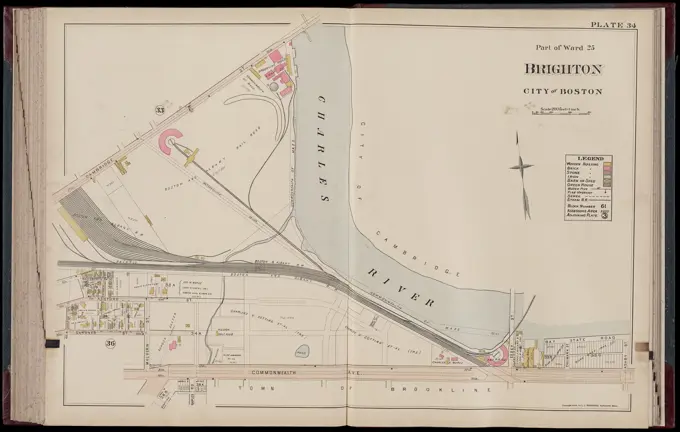
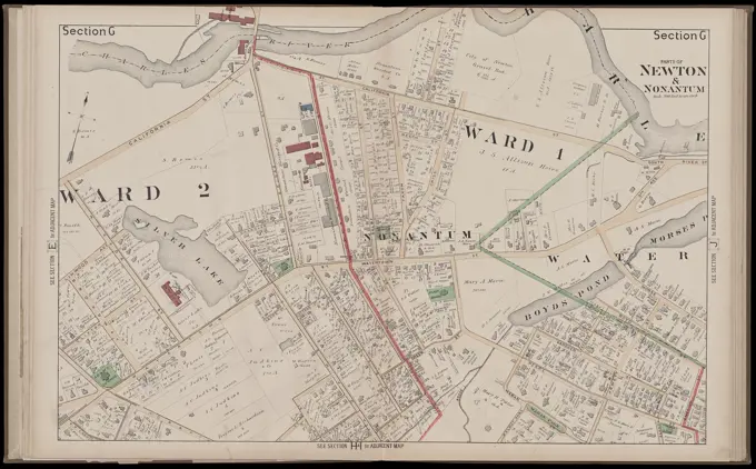
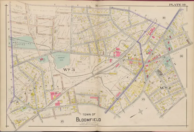
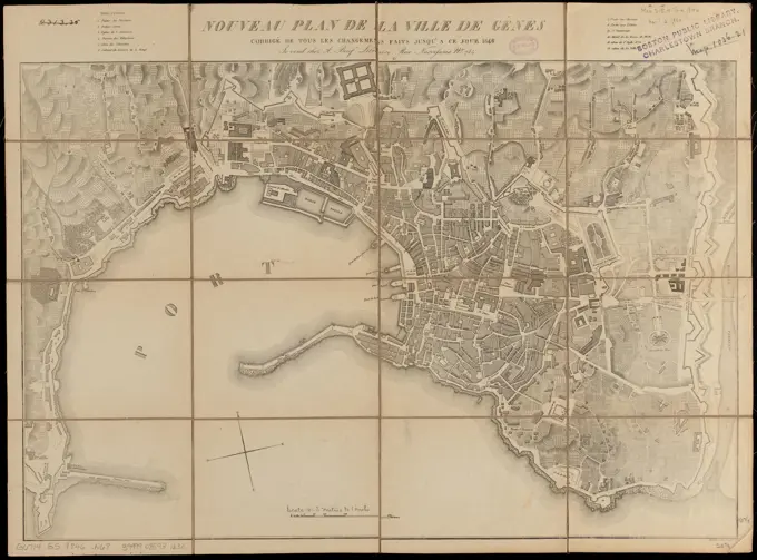
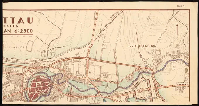
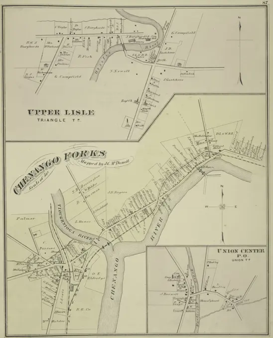
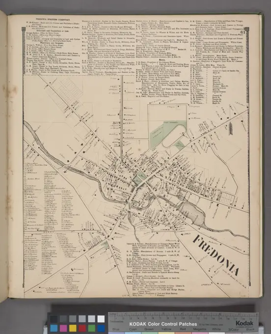
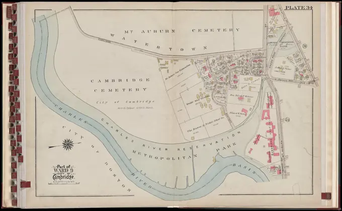
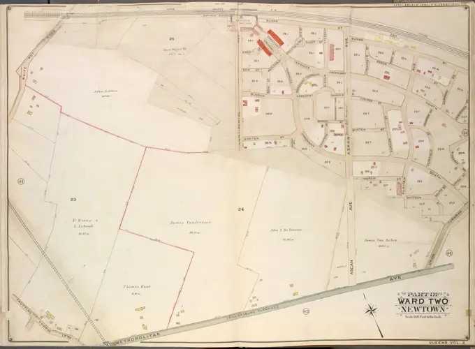
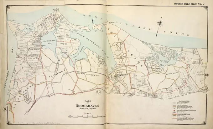
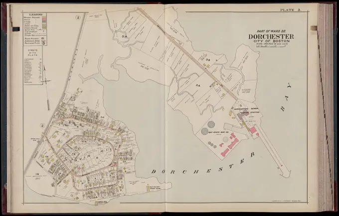
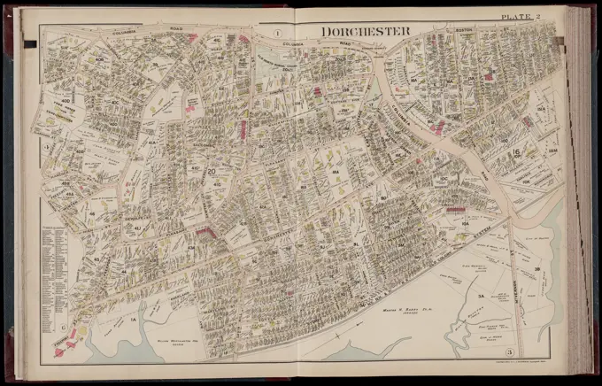
Detailed historical maps showcasing various neighborhoods in Boston, including Brighton, Dorchester, and Jamaica Plain, with landowner information.

Atlas of the city of Boston : Dorchester : volume three : from actual surveys and official records : plate M , Real property, Massachusetts, Boston, Maps, Landowners, Massachusetts, Boston, Maps, Mattapan Boston, Mass., Maps Norman B. Leventhal Map Center Collection
Map of Hyde Park and Vicinity : Norfolk County, Mass , Hyde Park Boston, Mass., Maps Norman B. Leventhal Map Center CollectionAtlas of the city of Chelsea and the towns of Revere & Winthrop, Massachusetts : from actual surveys and official plans. plate 32 , Real property, Massachusetts, Winthrop, Maps, Landowners, Massachusetts, Winthrop, Maps, Winthrop Mass., Maps Norman B. Leventhal Map Center CollectionJansen Hermann (1869-1945), Planning for Plowdiw (June 16, 1944): Proslaw, Zarski Ostrow, traffic development, site plan 1: 5000. Tusche over a break on transparent, 60.4 x 92.2 cm (including scan edges) Jansen Hermann  (1869-1945): Planung für PlowdiwA map of Plymouth Village : 1846 , Plymouth Mass. : Town, Maps Norman B. Leventhal Map Center CollectionMAP OF MARSEILLE, FRANCEJansen Hermann (1869-1945), Planning for Plowdiw (June 14, 1944): Proslaw, development plan, site plan 1: 2000. Ink over a break on transparent, 60 x 94.9 cm (including scan edges) Jansen Hermann  (1869-1945): Planung für PlowdiwCity atlas of Boston, Massachusetts : complete in one volume : from official records, private plans and actual surveys : plate 14 , Real property, Massachusetts, Boston, Maps, Landowners, Massachusetts, Boston, Maps, South Boston Boston, Mass., Maps, Roxbury Boston, Mass., Maps Norman B. Leventhal Map Center CollectionHempstead Cartographic. Maps. 1859. Lionel Pincus and Princess Firyal Map Division. Landowners , New York (State) , Hempstead, Hempstead (N.Y.)Plan Showing the Ascertained Deaths from Cholera...City of New York, boroughs of Manhattan and the Bronx: map showing section stations, stables and dumps Map of the City of New York Cartographic. Maps. 1906. Lionel Pincus and Princess Firyal Map Division. Manhattan (New York, N.Y.), New York (N.Y.), Stables , New York (State) , New York, Street cleaning , New York (State) , New York, Refuse and refuse disposal , New York (State) , New YorkAtlas of Dorchester, West Roxbury and Brighton, city of Boston : plate 34 , Real property, Massachusetts, Boston, Maps, Landowners, Massachusetts, Boston, Maps, Allston Boston, Mass., Maps Norman B. Leventhal Map Center CollectionMap of the proposed channel between Utrecht and the Zuiderzee, 1720; New and neat marking from the Gravinge that is to be made to take place starts from the Stadt Utrecht to Spakenborg in the Zuyder Sea with the even baking & C; The great scene of foolishness. Card in two parts of the proposed channel to dig between Utrecht and the Zuiderzee. Money was collected in 1720 for this project. At the bottom right: a scale of 1000 stying rods. Print in the bound first edition (304 B 10) of the great scene of foolishness with cartriders at the 1820 wind trade or action trade.Plate 75, Part of Sections 8&13, Borough of the Bronx. Bounded by Netherland Avenue, W. 235th Street, Spuyten Duyvil Road, W. 236th Street and Broadway.Map of the principal part of Boston, and adjacent cities, for 1873Double Page Plate No. 38, Part of Ward 24, Section 12. Bounded by E. 211th Street Woodlawn Cemetery, Webster Avenue, E. 209th Street, Reservoir Oval West, and Wayne Avenue.City of Utica. Shows buildings, railroads, wards, and radial distances from City Hall. Oriented with north toward the upper left. Insets: Deerfield annexation, 16th ward -- Village of New Hartford -- Subplan section between city of Utica and New Hartford Village. Includes guide to street numbers. Accompanied by street directory (48 p. ; 20 cm.).. Map. street directory, and guide of Utica. Map. street directory, and guide of Utica, New York  , Oneida  ,county   , UticaAtlas of the city of Newton, Massachusetts. section G , Real property, Massachusetts, Newton, Maps, Landowners, Massachusetts, Newton, Maps, Newton Mass., Maps Norman B. Leventhal Map Center CollectionCity of Chelsea with the location of its churches, schools and principal industries , Chelsea Mass., Maps Norman B. Leventhal Map Center CollectionKnoblauch Eduard (1801-1865), villa with a long-haul streak in Swiss style (without date): site plan. Ink and pencil watercolored, 80 x 92.8 cm (including scan edges)Cartography, Italy. Topographic plan of the Villa Medici di Castello in Florence, Tuscany region.Plan of Kingston made by John Gray, dated 1831 ,. Massachusetts. Office of the Secretary of StateAtlas of the city of Boston : Roxbury, Mass. : volume three : from actual surveys and official records : index map , Roxbury Boston, Mass., Maps, Jamaica Plain Boston, Mass., Maps, Fenway Boston, Mass., Maps, Mission Hill Boston, Mass., Maps Norman B. Leventhal Map Center CollectionMap of Ath with inundations, 1707, Samuel Du Ry de Champdoré, 1707, Map of the fortifications around the city of Ath, with the inundations in the year 1707. Top right a cartouche with the legend a-R in French and Dutch. Part of a collection of drawn plans of fortified towns in the Netherlands and surrounding countries at the time of the War of the Spanish Succession (part C)., draughtsman: Samuel Du Ry de Champdoré, (mentioned on object), Netherlands, 1707, paper, h 465 mm × w 610 mmMap of the city of Utrecht.Atlas of the town of Brookline, Norfolk County, Massachusetts : from actual surveys and official plans. plate E , Real property, Massachusetts, Brookline, Maps, Landowners, Massachusetts, Brookline, Maps, Brookline Mass., Maps Norman B. Leventhal Map Center CollectionWestchester, V. 2, Double Page Plate No. 16 Map bounded by Village of Irvington, Landers Rd., Ashford Ave. Cartographic. Atlases, Maps. 1910 - 1911. Lionel Pincus and Princess Firyal Map Division. Westchester County (N.Y.), Real property , New York (State) , Westchester CountyAtlas of the city of Newton, Massachusetts. section D , Real property, Massachusetts, Newton, Maps, Landowners, Massachusetts, Newton, Maps, Newton Mass., Maps Norman B. Leventhal Map Center CollectionMap of Sluis, ca. 1701-1715, Samuel Du Ry de Champdoré, 1701 - 1715, Map of the fortifications around the town of Sluis, ca. 1701-1715. Top right a drapery with legend A-Z in Dutch. Part of a collection of drawn plans of fortified towns in the Netherlands and surrounding countries at the time of the War of the Spanish Succession (part C)., draughtsman: Samuel Du Ry de Champdoré, Netherlands, 1701 - 1715, paper, h 538 mm × w 740 mmPart of Ward 6, Plate O, issued in 1881 by The Company, Troy, N.Y., located in PhiladelphiaPart of a map of the Rijnland Water Board, with Gouda and the surrounding area, Floris Balthasarsz. Van Berckenrode, 1615 print Part of a map of Rijnland, consisting of 27 parts.  paper etching / engraving maps of separate countries or regions Rijnland. GoudaJansen Hermann (1869-1945), revision and addition to the development plan of the Royal Domain Dahlem, Berlin (1910-1910): Overview and parceling plan on basic maps 1: 4000. Ink colored, over pressure on cardboard, 114.8 x 99.3 cm (including scan edges) Jansen Hermann  (1869-1945): Revision und Ergänzung des Bebauungsplanes der Königlichen Domäne Dahlem, BerlinMap of the townships of Hamilton & Cox, Bay of Chaleurs, District of Caspe, Lower Canada. Shows settlements and lots. Oriented with north to the upper left. Includes acreage list and location map... Map of the townships of Hamilton & Cox, Bay of Chaleurs, District of Gaspe, Lower Canada. Map of the townships of Hamilton & Cox, Bay of Chaleurs, District of Gaspe, Lower Canada, Canada  , Quebec  ,province   , Bonaventure Canada  , Quebec  ,province   , New-CarlisleBrentwood, Greenville, and Bayshore Village, 1888, Wendelken & Co., F.W. Beers & Co. Atlases, New York (State), Suffolk County., 1888., New YorkA new plan of Boston : drawn from the best authorities with the latest improvements, additionas and corrections , Boston Mass., Maps Norman B. Leventhal Map Center CollectionCartographic, Maps. 1907. Lionel Pincus and Princess Firyal Map Division. Staten Island (New York, N.Y.), New York (N.Y.), Real property , New York (State) , New York (N.Y.) Plate 28, Part of Wards 2 & 4: Map bound by Richmond Turnpike, Clove Oak St, Richmond Road, Clove Ave, The Staten Island Railway Co., Old Town Road, Ocean Terrace, Todt Hill Road, Chestnut AveUrbis romae iconographia (Iconography of the City of Rome), after Giovanni Battista Nolli (Italian, 1701-1756), after Leonardo Bufalini (Italian, 1486/1500-1552), Plate1.  Engraver: Francesco Monaco, Italian, 1733-1795 Engraver: Carlo Nolli, Italian, 1710-1785 After: Giovanni Battista Nolli, Italian, 1701-1756 After: Leonardo Bufalini, Italian, 1486/1500-1552A map of Hartford, Connecticut, dated approximately between 1870 and 1890, depicting real property and landowners. The map is 24 x 19 cm in size, mounted on a sheet measuring 26 x 22 cm. The publisher is not identifiedEssex County, V. 3, Double Page Plate No. 14 Map bounded by Washington Pl., Park St., Liberty St., Morris Canal, Charles St. A.H. Mueller (Publisher). Cartographic. Atlases, Maps. 1906. Lionel Pincus and Princess Firyal Map Division. Essex County (N.J.), Newark (N.J.)A May 1865 watercolor and pen drawing by Theophil Hansen showing the situation plan for a competition project including the House of Representatives and a manor house, with black and red pen details.Boston Harbor Mass : Charles River from Brookline Street bridge to Market Street bridge. Depths shown by soundings. "Boston Harbor Line Board Sheet K." "This map is compiled from surveys of the U.S. Engineers, the State Harbor and Land Commissioners and the City Engineers of Boston and Cambridge."... , Massachusetts  , Charles  ,river  Massachusetts  , Boston HarborAtlas of the city of Boston : West Roxbury : volume five : from actual surveys and official records : index map , Jamaica Plain Boston, Mass., Maps, Roxbury Boston, Mass., Maps, Roslindale Boston, Mass., Maps, West Roxbury Boston, Mass., Maps Norman B. Leventhal Map Center CollectionNouveau plan de la ville de Genes : corrige de tous les changemens faits jusqu'a ce jour, 1846. Relief shown by hachures. Oriented with north towards the upper left.... , Italy  , Liguria  ,region   , Genova  ,province   , GenoaPart of the metropolitan district. 66 and "67" in upper margin... Part of the (Needham and Dedham) metropolitan district. Part of the (Needham and Dedham) metropolitan district, Massachusetts  , Norfolk  ,county   , Dedham Massachusetts  , Norfolk  ,county   , NeedhamAtlas of the city of Newton, Massachusetts. section Q , Real property, Massachusetts, Newton, Maps, Landowners, Massachusetts, Newton, Maps, Newton Mass., Maps Norman B. Leventhal Map Center CollectionJansen Hermann (1869-1945), development plan of the city expansion, Sprottau in Silesia (03.11.1927): (As Inv.No. 21421): basic plan 1: 2500, consisting of four parts, sheet 2, scale bar. Colored pencils over pressure on cardboard, 69.2 x 129.4 cm (including scan edges) Jansen Hermann  (1869-1945): Bebauungsplan der Stadterweiterung, SprottauA historical map titled 'Upper Lisle, Triangle TP; Chenango Folks; Union Center P.O., Union TP Villages,' published in 1876 by Everts, Ensign & Everts in Philadelphia. The map features Broome County, New York, and specifically the town of UnionCity of Somerville : ward 3 : voting precincts , Somerville Mass., Administrative and political divisions, Maps Norman B. Leventhal Map Center CollectionOrth August (1828-1901), cattle market and slaughterhouse in Berlin. Building plan Ackerstraße/ Brunnenstraße from 1862 (1862): development plan. Ink, ink colored, watercolor, over pressure on paper, 51.4 x 64.1 cm (including scan edges)Flat land / der city / utrechtN.N., station facilities, Düsseldorf. (From: Atlas to the magazine for Building, ed. V. Ministry of Public Works, Jg. 44, 1894): Overview plan 1: 20000. Stitch on paper, 42.6 x 54.5 cm (including scan edges)Plan of Andersonville Prison or Camp Sumter April 1864Vrbis Romae ichnographia , 1755. 1755 Plan of modern Rome, copied from Giambattista Nolli's 1748 etched reduction of Leonardo Bufalini's large woodcut, first published 1551. See Huelsen, Scaccia-Scarafoni. Printed on 2 large sheets joined at vertical margins. Title proper and imprint on cartouche at upper left with arms of Clement XI, followed by a note entitled "Monitum." Additional title at top center: ROMA. To the right of the cartouche is a note explaining the color coding: red for the city, yellow for antiquities, violet for ecclesiastical buildings. Index of 307 names of buildings and sites keyed to the plan, in two parts at left and right margins. In lower left corner a view of the Pantheon, in lower right a view of the Temple of Janus. Oriented with north at top. Relief shown by hachures. On verso of Getty copy are written in ink "67", followed by "67 Rom" within a circle, apparently pertaining to an old collection. Property stamp at lower right verso of C E Rappaport (ie Carl Map of the Schermer after completion of the dike and raffle of the plots, 1635, Salomon Rogiers, after Pieter Wils, in or after 1635 - Before 1640 print Map of the Schermerpolder after completion of the dike and raffle of the plots on October 25, 1635. In the top left of a weapon with a guardian angel: Scher-Meers protector (possibly the then weapon of the polder). At the top right the title cartouche. At the bottom right two scale sticks: 500 SCHER-LEER LAND-ROEDS; 500 SCHER-LEER DYCK-ROEDS. Amsterdam paper engraving maps of separate countries or regions. coat of arms (as symbol of the state, etc.). polder, reclaimed land FencerCartographic, Maps. 1908 - 1912. Lionel Pincus and Princess Firyal Map Division Queens, Vol. 2, Double Page Plate No. 13; Part of Ward Two Newtown; Map bounded by Long Island City, Cabinet St., Bowery Bay Road, Shore Road; Including Old Bowery Bay Road, Kouvenhoven Ave., Astoria and Flushing TurnpikeReichborns kart over Christiania, 1811 - Cartographer I.H. Reichborn.Part of the town of Southbridge, Worcester Co. , MapPlan of modern Rome. Includes references to points of interest and profile: A comparison of the principal modern buldings in Rome. "Published under the superintendence of the Society for the Diffusion of Useful Knowledge."... , Italy  , Latian  ,region   , Roma  ,province   , RomeMap of the proposed channel between Utrecht and the Zuiderzee, 1720; New and neat marking from the Gravinge that is to be made to take place starts from the Stadt Utrecht to Spakenborg in the Zuyder Sea with the even baking & C; The large scene of foolishness.Card in Two Parts of the Proposed Channel to Dig Between Utrecht and the Zuiderzee. Money was collected in 1720 for this project. At The Bottom Right: A Scale of 1000 Stying Rods. Print 6 in the Series The Great Scene of Foolishness With cartriders at the 1820 Wind Trade or Action Trade.Morris County, Double Page Plate No. 5 Map bounded by Danforth Ave., Ridgedale Ave., Shunpike Rd. 1910. Cartographic. Atlases, Maps. Lionel Pincus and Princess Firyal Map Division. Morris County (N.J.)1873 Beers Map of the town of Huntington, Long Island, New YorkPalermo planFirst state / van den Ouden / Burgt and the city / Utrecht / (Trajectum) / under Dagobert I, King of the / Franken, Clodovicus and Pepyn / Den Ouden, in the year / 690.Drawing..Fredonia business Directory; Fredonia Village Cartographic. Atlases, Maps. 1867. Lionel Pincus and Princess Firyal Map Division. Chautauqua County (N.Y.), Real property , New York (State) , Chautauqua County, Business enterprises , New York (State) , Chautauqua CountyCartographic, Maps. 1880. Lionel Pincus and Princess Firyal Map Division. Brooklyn (New York, N.Y.), Real property , New York (State) , New York Plate 35: Bounded by Gravesend Bay, Sheepshead Bay, Manhattan Beach and Atlantic Ocean. Map of Coney Island, New York.Atlas of the city of Cambridge, Massachusetts : from actual surveys and official plans. plate 34 , Real property, Massachusetts, Cambridge, Maps, Landowners, Massachusetts, Cambridge, Maps, Cambridge Mass., Maps Norman B. Leventhal Map Center CollectionMAP OF ELBEUF, FRANCEMap with the lots of the Wormers, Laurens van Teylingen, 1668 print Map of the Polder de Wormer, or Wijdewormer, with plot distribution. At the top left a wind rose. Below an angel, who shows a canvas with an opened passer above a bowl: 300 Rynlant rods. At the top right an extensive table with information about the 119 on the map numbered plots. To the left of a cartouche with a ten -line text in Dutch. At the bottom right the title cartouche. In addition, the weapon of Purmerend, next to a map of that city. Amsterdam paper engraving maps of separate countries or regions. maps of cities. polder, reclaimed land. coat of arms (as symbol of the state, etc.) (+ city; municipal). angels Wormer. Wijdewormer. Get worse. PurmerendCartographic, Maps. 1884 - 1936. Lionel Pincus and Princess Firyal Map Division. Fire insurance , New York (State), Real property , New York (State), Cities & towns , New York (State) Key ContinuedTown of Dedham Massachusetts. Oriented with north toward the upper left.... , Massachusetts  , Norfolk  ,county   , DedhamCartographic, Maps. 1908 - 1912. Lionel Pincus and Princess Firyal Map Division Queens, Vol. 2, Double Page Plate No. 45; Part of Ward Two Newtown; Map bounded by Burns St., Underwood Road, Ridgeway Road, Upton St., Union Turnpike, Metropolitan Ave. (Williamsburg Turnpike), Trotting Course Lane, White Pot RoadPart of Brookhaven Suffolk County Cartographic. Atlases, Maps. 1915 - 1917. Lionel Pincus and Princess Firyal Map Division. Suffolk County (N.Y.)MAP OF BAYONNE, FRANCEAtlas of the city of Cambridge, Middlesex Co., Massachusetts. plate A , Real property, Massachusetts, Cambridge, Maps, Landowners, Massachusetts, Cambridge, Maps, Cambridge Mass., Maps Norman B. Leventhal Map Center CollectionAsbury Village; Bloomsbury Village, 1873., 1873., New York, N.Y., Hunterdon County (N.J.). MapsCamping of the Prussia in Tienhoven, 1787, Anonymous, 1790 - 1792 print Map with the location of the camps of the Prussian troops near Tienhoven on September 18, 1787. Part of a group of fourteen numbered cards of the camps of the Prussian troops during the intervention in the Netherlands in September 1787. Northern Netherlands paper etching maps of cities TienhovenAtlas of the town of Brookline, Massachusetts : from actual surveys & official records. plate H , Real property, Massachusetts, Brookline, Maps, Landowners, Massachusetts, Brookline, Maps, Brookline Mass., Maps Norman B. Leventhal Map Center CollectionNorth Fenton, Fenton TP.; Triangle, Triangle TP. ; Whitney's Point. Cartographic. Atlases, Maps. 1876. Lionel Pincus and Princess Firyal Map Division. Broome County (N.Y.)Map of West Roxbury Park in the West Roxbury district of Boston, issued in 1876 by the Park Department of the City of Boston. The map is in color and measures 61 x 67 cmEssex County, V. 3, Double Page Plate No. 34 Map bounded by part of Millburn Township A.H. Mueller (Publisher). Cartographic. Atlases, Maps. 1906. Lionel Pincus and Princess Firyal Map Division. Essex County (N.J.), Newark (N.J.)Northern Netherlands, No. 11. Camp at Tienhoven, 18 September, 1787, Kampement van de Pruisen te Tienhoven, verso - stamped, Map showing the location of the camp of the Prussian troops at Tienhoven on 18 September 1787. Part of a group of fourteen numbered maps of the camps of the Prussian troops during the intervention in the Netherlands in September 1787., print, picture, map, book illustration, prints, images, Frederik Muller Historieplaten, height 75 mm, width 162 mm, print maker, printmaker, 1790 - 1792, paper, papier, etching, etchings, hand colouringDrawn Map of Menen, 1688; Plan the menin. Signed map of the reinforcements to the city of Menen, 1688. At the top right a cartouche with the title and legend A-N in French.Map of Amsterdam, Martin Ghys, 1873 print  Rotterdam paper  maps of cities AmsterdamAtlas of the county of Suffolk, Massachusetts : vol. 1st including Boston proper : from actual surveys and official records : plate Z , Real property, Massachusetts, Boston, Maps, Landowners, Massachusetts, Boston, Maps, Boston Mass., Maps Norman B. Leventhal Map Center CollectionAtlas of Dorchester, West Roxbury and Brighton, city of Boston : plate 3 , Real property, Massachusetts, Boston, Maps, Landowners, Massachusetts, Boston, Maps, Dorchester Boston, Mass., Maps Norman B. Leventhal Map Center CollectionMap of Geldern, ca. 1701-1715; Plan De La Ville de Gueldre avec la carte de ses environs. Map of the reinforcements around the city of Geldern, with surroundings, approx. 1701-1715. On the right the legend 1-36 in French. Part of a collection of signed plans of reinforced places in the Netherlands and surrounding countries at the time of the Spanish Succession War (Part B).The Grand Career district (the 69th Paris Administrative District), 18th arrondissement1873 Beers Map of Sag Harbor, New YorkAtlas of the city of Cambridge, Middlesex Co., Massachusetts. plate B , Real property, Massachusetts, Cambridge, Maps, Landowners, Massachusetts, Cambridge, Maps, Cambridge Mass., Maps Norman B. Leventhal Map Center CollectionMap of Boston proper, Charlestown, South Boston and East Boston : showing original territory of old Boston, the areas filled and reclaimed from tide water and the areas available for future reclamation ... port of Boston , Cities and towns, Growth, Massachusetts, Boston, Maps, Boston Mass., Maps, Boston Harbor Mass., Maps Norman B. Leventhal Map Center CollectionAtlas of Dorchester, West Roxbury and Brighton, city of Boston : plate 2 , Real property, Massachusetts, Boston, Maps, Landowners, Massachusetts, Boston, Maps, Dorchester Boston, Mass., Maps Norman B. Leventhal Map Center Collection1867 Beers Map of Peekskill, Westchester, New YorkPlan of RheinbergPart of Bridge Hampton; Shelter Island Heights Cartographic. Atlases, Maps. 1915 - 1917. Lionel Pincus and Princess Firyal Map Division. Suffolk County (N.Y.)Part of New York in 1742 : showing the site of the present park, the collect and the little collect ponds, and a portion of the west side of Broadway. Relief shown by hachures. Hand colored. Oriented with north to the upper right.... , New York  , New York  , ManhattanCity of Lawrence, precincts 9 & 10, ward 5 ,. Lawrence Public Library Map CollectionReuter Fritz, development plan for Berlin-Reinickendorf (01.04.1917): Department of Subs with industrial track systems 1: 4000. Print watercolor on paper, 70.1 x 80.7 cm (including scan edges) Reuter Fritz : Bebauungsplan Berlin-ReinickendorfMap of the Alblasserwaard, Anonymous, c. 1700 - c. 1750 print Map of the area north of the Merwede River and west of the Noorder Diep. When these rivers come together: Dordrecht ..  paper etchingComplete Map of New York City and Vicinity. 1903. Cartographic. Maps. Lionel Pincus and Princess Firyal Map DivisionMap of the cities of Albany and Rensselaer, New York. Oriented with north to the upper left. Inset: Sub plan showing western continuation.... , New York  , Albany  ,county   , Albany New York  , Rensselaer  ,county   , Rensselaer