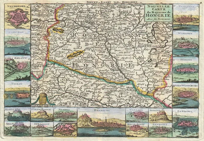
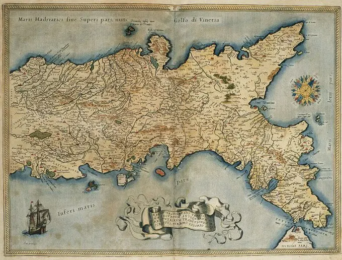
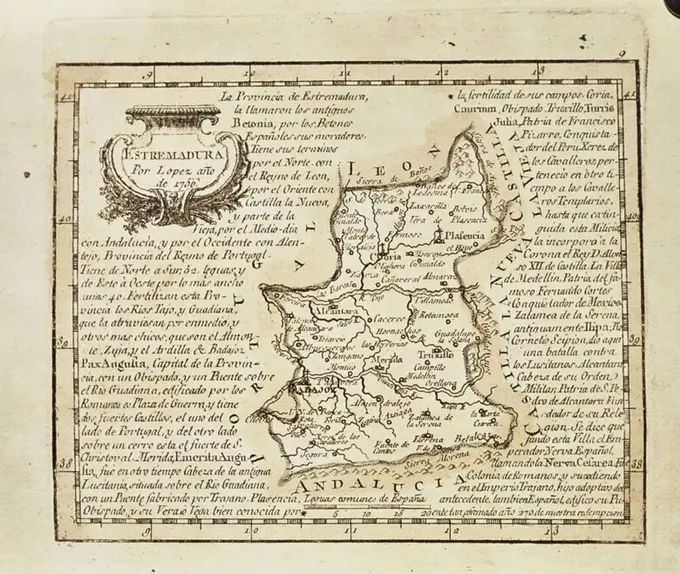
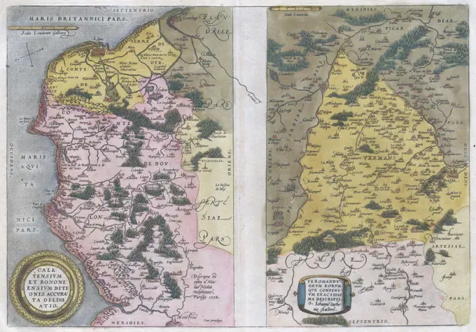
Historical Maps of Europe and Asia

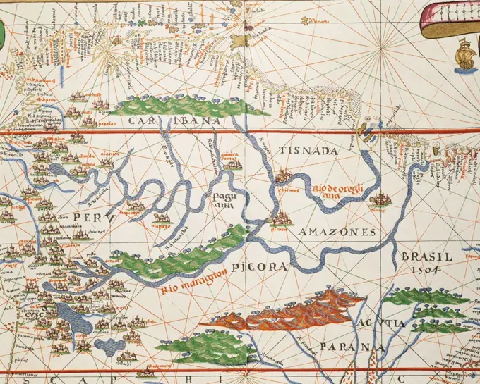
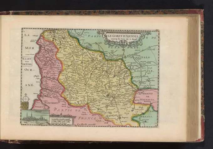
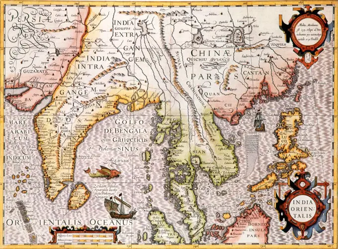
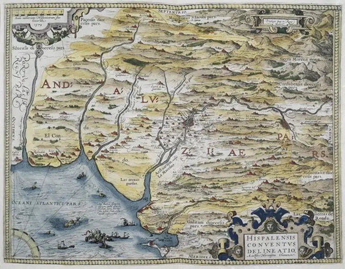
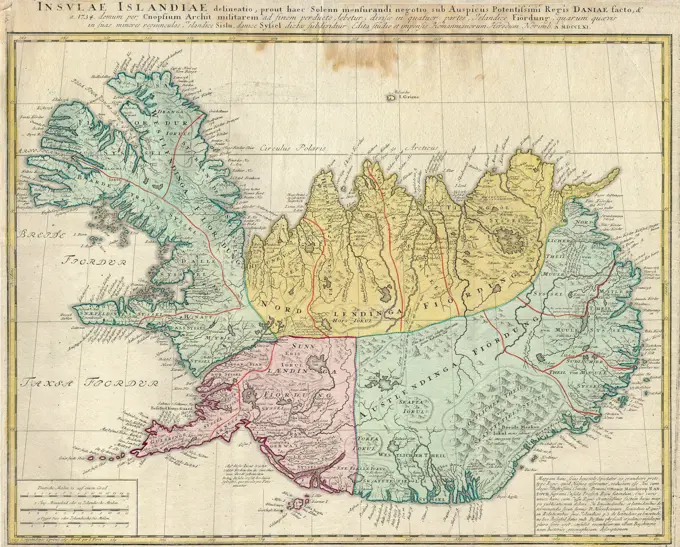
Digitally restored historical maps from the 17th century, showcasing regions in Germany, England, and Asia, with intricate designs and geographical details.

Atlas, map from 1623, Northumbria, one of the Anglo-Saxon petty kingdoms of England, digitally restored reproduction from an engraving by Gerhard Mercator, born as Gheert Cremer, March 5, 1512 - December 2, 1594, geographer and cartographer.
Puzzle (puzzle) Geographic atlas  the El European Delamarche, FelixGallia vetus : ad Iul Caesaris commentaria ex conatibus geographicis , France, Maps, Early works to 1800, Gaul, Maps, Early works to 1800 Norman B. Leventhal Map Center CollectionVtrivsque Castiliae Nova Descriptio; Schenck, Pieter (1660-1711), Valck, Gerard (1651 cars 1652-1726); 1711 (1711-00-00-1711-00-00);Map of Flanders, 1559 print Map of Flanders. At the bottom two cartouches with the title and a inscription to the reader, bottom left the Passer with Scales. At the top left a wind rose. All inscriptions in Latin. print maker: Italy (possibly)publisher: Venice paper engraving maps of separate countries or regions FlandersQuarta et Ultima Affrice tabula continet interiorem Libya Ethyopiam q sub Egypto e & q est interius cu insulis ei adiacentibus. Title from verso. Map of the northern half of the African continent. Relief shown by brown coloring. Engraved on wood with place names in moveable type. Includes names of places and natural features. In margin: notes on latitude. Appears in the author's Geographia. Ulm : Lienhart Hol, 16 July 1482. Text in Latin. Cataloging, conservation, and digitization made possible in part by The National Endowment for the Humanities: Exploring the human endeavor.... , Africa AfricaCanton Solothurn sive pagus Helvetiae Solodurensis cum confinibus ... 1766. Cartographic. Maps. Lionel Pincus and Princess Firyal Map Division. Italy , Maps, Switzerland , MapsMap of Gelderland, Anonymous, 1757 - 1777 print Bottom left the title cartouche and two scale sticks: 4 Milliaria Germanica Communia / 5 Milliaria Gallica Communia Seu Horae Itineris. Above the cartouche the weapon of Gelre and the city of Zutphen. Around the cartouche figures. At the top left a legend. The card is equipped with a degree distribution along the edges.  paper etching / engraving maps of separate countries or regions. coat of arms (as symbol of the state, etc.) (+ province; provincial). coat of arms (as symbol of the state, etc.) (+ city; municipal). hunting, chase Guilders. Gelderland. ZutphenCartography, 16th century. Map of Netherlands, from Theatrum Orbis Terrarum by Abraham Ortelius (1528-1598), Antwerp, 1570.Neuchtel map; Caarte van Neufchatel et Valangin. Map of the Neuchtel canton. At the bottom of the weapons of the princes of Neuchtel and a face on the city. Part of an Atlas with 223 maps of countries and cities and war scaffolding in Europe in the period approx. 1690-1735.To Her most Sacred Majesty Carolina Queen of Great Britain, France & Ireland, this map of Europe, according to the newest and most exact observations, is most humbly dedicated , Europe, Maps, Early works to 1800, Caroline, Queen, consort of George II, King of Great Britain, 1683-1737 Norman B. Leventhal Map Center CollectionPlan of Boston surveyed by Osgood Carleton, dated 1795. ,. Massachusetts. Office of the Secretary of Statecartography maps Portugal and colonies in Brazil copper engraving ""Atlas Novus"" by Georg Matthaeus Seutter printed by Peter von Bhelen Vienna 1728 private collection,Quarta Europae tabula , Europe, Central, Maps, Early works to 1800, Germany, Maps, Early works to 1800 Norman B. Leventhal Map Center CollectionAccuratissima principatus Cataloniae, et comitatuum Ruscinonis, et Cerretaniae descriptio , Catalonia Spain, Maps, Early works to 1800 Norman B. Leventhal Map Center CollectionLa Suisse divisee en ses treze cantons, ses alliez & ses sujets 1751. Cartographic. Maps. Lionel Pincus and Princess Firyal Map Division. Italy , Maps, Switzerland , MapsMap of Constantinople, modern day Istanbul, 1730, Turkey 18th century.Portolan atlas of the world by Joan Martines (1556-1590). Messina, 1587. Amazon basin and two mouths. National Library. Madrid. Spain.Map of the quarter of Nijmegen, Anonymous, 1662 print At the top left Putti with five coats of arms with the weapons of Tiel, Nijmegen and Zaltbommel. The coats of Culemborg and Buren are blank. To the right of the title cartouche and the top right of the Wapen van Gelderland. Bottom left a legend, to the right of a bowl: 2 Hore ITineris / Scala of two hours of gaens. On Verso Latin text.  paper engraving maps of separate countries or regions. coat of arms (as symbol of the state, etc.) Gelderland. Nijmegen. Culemborg. Tiel. Zaltbommel. NeighborsEuropae , Europe, Maps, Early works to 1800 Norman B. Leventhal Map Center CollectionMap of the Mediterranean with parts of Europe, North Africa and the Middle East (Ottoman Empire), Nicolaes Visscher (I), 1650 - 1700  Map of the Turkish Empire, areas colored, trees, mountains and buildings signed, yellowed yellow. Windroos m. M.O. Round inscription Krijgs and Allegorical scene with regard to the Turkish sultan. R.o. legend. Inscription; M.O.: Magni / Turcarum Domini / empire / in. Europe, Asia, et Africa; ....etc. Signed; M.O.: per Nicolaum Visscher Amst: Bat: M.O.: Tideman f. G.V. Gouwen sch. Amsterdam paper engraving maps of separate countries or regions Mediterranean. Ottoman Empire. North-Africa. Europe. Middle East. Black SeaA map of the biblical Palestine with three biblical scenes: Moses and the ten commandments; the serpent on the pole; Christ healing the insane; the Crucifixion. Coloured etching after G. Rogg.Map of Brabant; Map of 't Duchdom Brabant. Map of the Duchy of Brabant, to the map twelve small floor plans of cities plus a face on Brussels. Part of an Atlas with 223 maps of countries and cities and war scaffolding in Europe in the period approx. 1690-1735.Carte de la Barbarie de la Nigritie et de la Guinee. Relief shown pictorially. Appears in the author's Atlas Nouveau. Amsterdam : Jean Covens & Corneille Mortier, 1757.... , West Africa  ,areaMap with the tour of Maurits by Brabant, 1602; Wary Aenwysinge with dots of DE journey of his Excellence Mauritio van Nassuanen with the army of the E. Magente Lord States Generael der Vereened Provintie N, Anno 1602 by T'landt van Luyck: Ende Int return by Brabant (..) To the Greeaf. Card on which the tour of the State Army under Prince Maurits has been mapped out by Brabant, June 7, July 18, 1602. With two cartouches with inscriptions and title in Dutch. Under a crankcase: 7 Scala Miliary Brabantiae et Germaniae.Kaart van Israel; Map of the Holy Land. .Map of Italian Coast above Rome, Theatro D'el Orbe La Tierra - OrteliusImperial Persia, 1724Nova Virginiae tabula. Relief shown pictorially. Longitude not shown; oriented with north towards the right. Large view of the interior of an Indian house with legend below "Status Regis Powhatan." Cartouches: title at top center; scale and publisher statement at bottom center; "Notarum explicatio" above Indian figure. Appears in the author's Le theatre du monde, ou, Nouuel atlas. Amsterdam: Iean Blaeu, 1650. Cataloging, conservation, and digitization made possible in part by The National Endowment for the Humanities: Exploring the human endeavor.... , Virginia MarylandMap of Rijnland-Palts, Anonymous, 1735 Map of Rijnland-Palatten. Part of an atlas with 223 maps of countries and cities and war scenes in Europe in the period ca. 1690-1735. print maker: Northern Netherlandspublisher: Amsterdampublisher: Amsterdam paper engraving  Palatinate. Rijnland-Palatinate Map of Rijnland-Palatten. Part of an atlas with 223 maps of countries and cities and war scenes in Europe in the period ca. 1690-1735. print maker: Northern Netherlandspublisher: Amsterdampublisher: Amsterdam paper engraving  Palatinate. Rijnland-PalatinateAtlas, map from 1623, Hannonia, Hainaut, Belgium, digitally restored reproduction from an engraving by Gerhard Mercator, born Gheert Cremer, 5 March 1512, 2 December 1594, geographer and cartographer, EuropeArtesia map; Le Comté d'Artois / Artois map. Map of De Graafschap Artesia, bottom left a small face on Arras. Part of an Atlas with 223 maps of countries and cities and war scaffolding in Europe in the period approx. 1690-1735.Atlas, map from 1623, Andalusia, Spain, digitally restored reproduction from an engraving by Gerhard Mercator, born as Gheert Cremer, 5 March 1512, 2 December 1594, geographer and cartographer, EuropeAfricae antiquae, et quarundam Europae, Asiaeque adiacentium regionum. Covers Africa from the Mediterranean to the Ruwenzori Mountains. Relief shown pictorially. Dedication: Viro amplissimo pientissimoque Iohanni Brunaeo, IC. et illustrium Zelandiae Ordinum Syndico meritissimo, Nicolaus Blancardus, eorum dem Ordinum Historicus dedicabat L.M.Q. Includes decorative cartouches and ill. of Hadrianic coins.... , West Africa  ,areaEnglish Counties' Map 1645. Accuratissima principatus Cataloniae, et comitatuum Ruscinonis, et Cerretaniae descriptio , Catalonia Spain, Maps, Early works to 1800 Norman B. Leventhal Map Center CollectionP. 1, before title pageP. 1, before title pageQuinta Asiae tabula , Iran, Maps, Early works to 1800 Norman B. Leventhal Map Center CollectionS. Imperium Romano Germanicum Oder Teutschland Mit Seinen Angrantzenden Konigreichen und Provincien ...; Schenck, Pieter (1660-1711), Valck, Gerard (1651 cars 1652-1726), Janssonius, Johannes (1588-1664); 1711 (1711-00-00-1711-00-00);Map of Israel, Jan Luyken, 1707 print  Amsterdam paper etching maps of separate countries or regions IsraelSpain and Portugal 1798 - 1804. Cartographic. Maps, Atlases. Lionel Pincus and Princess Firyal Map Division. Atlases , Great Britain, Maps in education , England, Historical geography, Spain, PortugalQuinta Asiae tabula , Iran, Maps, Early works to 1800 Norman B. Leventhal Map Center CollectionTabula II Europae , Iberian Peninsula, Maps, Early works to 1800, Spain, Maps, Early works to 1800, Portugal, Maps, Early works to 1800 Norman B. Leventhal Map Center CollectionMap of the Seventeen Provinces, 1740 - 1757 print At the top right TitleCartouche with the weapons of the seventeen provinces, two putti with a trumpet, Mars, Mercury, Neptunus and Minerva. Below that: Milliaria Germanica Communia 15 in Uno Gradu, Milliaria Gallica Sive Horae Itineris, Milliaria Italica 60 in Uno Gradu. Bottom left cartouche with around Mars, Fama, Ceres and a number of putti. The card is equipped with a search schedule and a degree distribution along the edges.  paper engraving maps of separate countries or regions. coat of arms (as symbol of the state, etc.). (story of) Mars (Ares). (story of) Mercury (Hermes). (story of) Minerva (Pallas, Athena). (story of) Neptune (Poseidon). Fame; 'Fama', 'Fama buona', 'Fama chiara' (Ripa). (story of) Ceres (Demeter) Low CountriesEuropae , Europe, Maps, Early works to 1800 Norman B. Leventhal Map Center CollectionHuntingdonensis comitatus = huntington shire; Schenck, Pieter (1660-1711), Valck, Gerard (1651 cars 1652-1726), Lairesse, Gerard de (1641-1711), Baptist, Jacobus (Fl. 1696-1704); 1711 (1711-00-00-1711-00-00);Jodocus Hondius (Dutch name: Joost de Hondt) (1563 - 1612) was a Flemish engraver and cartographer. He helped establish Amsterdam as the center of cartography in Europe in the 17th century.Map of America. Reduced facsimile of a map from the Spanish Atlas published in Messina, 1582. From Science and Literature in The Middle Ages by Paul Lacroix published London 1878ORTELIUS, Abraham (1527-1598). Theatrum Orbis Terrarum. 1570. It is considered to be the first modern atlas. Map of Western Andalusia. Based in the map of Hironimus Chiaves (Jer—nimo de Chaves). Printed in Antwerp by Christophe Plantin (1588). Etching. BELGIUM. FLANDERS. ANTWERP. Antwerp. Museum Plantin-Moretus.Dioecese de rheims et le pais de rethel; Schenck, Pieter (1660-1711), Valck, Gerard (1651 cars 1652-1726); 1711 (1711-00-00-1711-00-00);A map of ye English empire in ye continent of America. Viz Virginia New York Mary Land New IJarsey Carolina New England.. Prints, Maps. 1679. The Miriam and Ira D. Wallach Division of Art, Prints and Photographs: Print Collection. Atlantic States, New EnglandTab. mo. Hispan , Iberian Peninsula, Maps, Early works to 1800, Spain, Maps, Early works to 1800, Portugal, Maps, Early works to 1800 Norman B. Leventhal Map Center CollectionTabula I Europae. Map of Great Britain and Ireland. Includes names of places and natural features. In margin: Climatic and latitudinal notes. Descriptive text within ornamental borders on verso. Appears in the author's Geographia, translated by Willibald Pirckheimer, with annotations by Joannes Regiomontanus. Argentoragi i.e. Strasbourg : Iohannes Grieningerus, communibus Iohannis Koberger impensis excudebat, anno a Christi Natiuitate 1525 tertio Kalendas Apriles. Text in Latin. Cataloging, conservation, and digitization made possible in part by The National Endowment for the Humanities: Exploring the human endeavor... Principum Europae. Principum Europae, Ireland United KingdomGuiana siue Amazonum regio , Guiana, Maps, Early works to 1800 Norman B. Leventhal Map Center CollectionDer Furstliche Abt Von St. Gallen und die Stadt St. Gallen ... 1768. Cartographic. Maps. Lionel Pincus and Princess Firyal Map Division. Italy , Maps, Switzerland , MapsMap of Asia Minor - Sanson Atlas, circa 1700Asiae nova , Asia, Maps, Early works to 1800, 1660-1665 Norman B. Leventhal Map Center CollectionTo Her most Sacred Majesty Carolina Queen of Great Britain, France & Ireland, this map of Europe, according to the newest and most exact observations, is most humbly dedicated , Europe, Maps, Early works to 1800, Caroline, Queen, consort of George II, King of Great Britain, 1683-1737 Norman B. Leventhal Map Center CollectionNegroland and Guinea : with the European settlements explaining what belongs to England, Holland, Denmark &c. Imprint derived from the atlas in which the map was issued. Shows boundaries, rivers and settlements. Numbered 48. Relief shown pictorially. London meridian. Appears in the author's Atlas minor. London: Printed for Tho. Bowles and John Bowles, 1732 or 1736 West Africa, showing River Niger.... , West Africa  ,areaTab. mo. Hispan , Iberian Peninsula, Maps, Early works to 1800, Spain, Maps, Early works to 1800, Portugal, Maps, Early works to 1800 Norman B. Leventhal Map Center CollectionA celebrated and elegant map by Willem and Joan Blaeu of the Moghul Empire. The map shows the Ganges, Bengal, Delhi, Lahor, Cashmere & Kabul; decorations include an ornate cartouche, galleons, elephants and camels. Of particular interest, to the east of the Moghul Empire the specious 'Chiamay Lacus' or 'Lake Chiang Mai' is particularly large and is represented as the source of five major rivers emptying into the Bay of Bengal and the South China Sea.Portuguese maps showing detailed views of  Zambezia (present day Mozambique )in Eastern Africa from a 1630 atlas.Moscovia or Russia. Divided into its general parts &c. Cartographic. Maps, Atlases. 1701. Lionel Pincus and Princess Firyal Map Division. GeographyCartography, Great Britain, Map of Hampshire.Quercy Olim Cadurcium; Schenck, Pieter (1660-1711), Valck, Gerard (1651 cars 1652-1726); 1711 (1711-00-00-1711-00-00);Episcopatus balbastrensis et comitatus ribagorcae; Schenck, Pieter (1660-1711), Valck, Gerard (1651 cars 1652-1726); 1711 (1711-00-00-1711-00-00);1747 La Feuille Map of HungaryA map of the country of the Hottentots, towards the Cape of Good Hope Cartographic. Prints, Maps. 1745 - 1747. Rare Book Division. Khoikhoi (African people)Map of Gelderland, Abraham Allard, 1725 - 1750 print Bottom left the title cartouche and two scale sticks: 4 common German mylen 15 in a degree / 5 common France Mylen or Uilen go. Above the cartouche the weapon of Gelre and the city of Zutphen. Around the cartouche figures and a hunting scene. At the top left a legend. The card is equipped with a search schedule and a degree distribution along the edges.  paper etching / engraving maps of separate countries or regions. coat of arms (as symbol of the state, etc.) (+ province; provincial). coat of arms (as symbol of the state, etc.) (+ city; municipal). hunting, chase Guilders. Gelderland. ZutphenMap of Overijssel, Anonymous, 1735 Map of Overijssel, Drenthe and Twente. Part of an atlas with 223 maps of countries and cities and war scenes in Europe in the period ca. 1690-1735. print maker: Northern Netherlandspublisher: Amsterdampublisher: Amsterdam paper engraving / lacquering  Overijssel. Drenthe. Twente Map of Overijssel, Drenthe and Twente. Part of an atlas with 223 maps of countries and cities and war scenes in Europe in the period ca. 1690-1735. print maker: Northern Netherlandspublisher: Amsterdampublisher: Amsterdam paper engraving / lacquering  Overijssel. Drenthe. TwenteMap of the Kingdom of Naples. Theatrum Orbis Terrarum by Abraham Ortelius (1527-1598). First Edition. Antwerp, 1574. Library of Catalonia. Barcelona. Spain.Nova Hispania et Nova Galicia , Mexico, Maps, Early works to 1800 Norman B. Leventhal Map Center CollectionStatus Milan, neither do not be drawn to Mantua, Modena, Parma, as a genuge of its neighbors with neighbors, with the neighbors of the Dominiss accurate delineatio; Schenck, Pieter (1660-1711), Valck, Gerard (1651 or 1652-1726); 1711 (1711-00-00 - 1711-00-00); Pobrano z systemu muza muzeum Narodowego W Warszawie; graficzne / c / c2 / miedzioryt kolorowany; Wyroby z w ókien / Papier / Papier Czerpany / Papier eberkowy; WYS. 49,0 cm, Szer. 57.2 cm; Kart.438 / 3/101 MNW; WSZYSTKIE PREWA ZASTREZE One.Map with the journey of Maurits through Brabant, 1602, Floris Balthasarsz. Van Berckenrode (Possible), 1612 - 1624 print Map on which the journey of the State Army under Prince Maurits was mapped out by Brabant, 7 June - 18 July 1602. With two cartouches with inscriptions and title in Dutch. Under a bowl: 7 Scala Miliarum Brabantiae et Germaniae.  paper etching / engraving maps of separate countries or regions. transport, train (military) BrabantMapa de Extremadura. Colección particular. Madrid. Author: Lopez.Tabula V Europae. Map of lands south of the Danube River, including present day Switzerland, Austria, Slovenia and Croatia. Relief shown pictorially. Includes names of places and natural features. Descriptive text within ornamental borders on verso. Appears in the author's Geographia, translated by Willibald Pirckheimer, with annotations by Joannes Regiomontanus. Argentoragi i.e. Strasbourg : Iohannes Grieningerus, communibus Iohannis Koberger impensis excudebat, anno a Christi Natiuitate 1525 tertio Kalendas Apriles. Text in Latin. Cataloging, conservation, and digitization made possible in part by The National Endowment for the Humanities: Exploring the human endeavor.... , Austria Slovenia Croatia Switzerland1666 map of Southwest Asia, showing Arabia, Persia, and Ottoman Empire.Venezuela cum parte Australi Novae Andalusiae , Venezuela, Maps, Early works to 1800 Norman B. Leventhal Map Center CollectionPays-Bas Catholiques, fig. 97, p. 217 Pays-bas Catholiques, vulgairement appelez la Flandre Cartographic. Maps. 1683. Rare Book Division. Europe , Maps, Belgium , MapsMap of Gelderland, Anonymous, 1612 - 1648 print Rechtsonder of titelcartouche. Linksonder Drie Schaalstoken: 5 Milliarin Little / 5 miles of moderate, the scale contains / 5 maximum five miles here steps. Rechtsonder genummerd: 18.  paper engraving maps of separate countries or regions Gelderland. Guilders. ZutphenPerigrinatie ofte veertich-iarige reyse der kindern Israëls, uyt Egypten door de Roode Zee, ende de woestyne, tot in't beloofde Landt Canaan , Geography, Maps, Early works to 1800, Illustrations, Exodus, The, Maps, Early works to 1800, Palestine, Maps, Early works to 1800, Israel, Maps, Early works to 1800 Norman B. Leventhal Map Center CollectionMap of the diocese of Tournai, Anonymous, 1697 - 1721 print Map of the diocese of Tournai. At the bottom left a French title cartouche, in a beam above the map the Dutch title. At the top right a frame with legend. At the top left a frame with three scale sticks: 6 Milles pass Geometriques ou Milles d'Italie / 2 Lieües de Flandres d'Ure de Chemin / 2 Lieües Communes de France. The card is equipped with a degree distribution along the edges.  paper engraving / etching maps of separate countries or regions Tour. French Flanders. TorlativeMap of Southwest England, 1709, 1709 Map of Southwest England, 1709. Part of a bundled collection of plans of battles and cities renowned in the Spanish Succession War. This album is one of the first 24 plates that together form a very large map of the Southern Netherlands. Brussels paper etching  England Map of Southwest England, 1709. Part of a bundled collection of plans of battles and cities renowned in the Spanish Succession War. This album is one of the first 24 plates that together form a very large map of the Southern Netherlands. Brussels paper etching  EnglandMap of Friesland and part of Groningen, Drenthe and Overijssel, c. 1697 print At the top right five scale sticks: Mille Pas Geometriques ou Milles d'Italie, Lieües Communes d'Altemagne, and three others. At the bottom right Cartouche. Equipped with search roster and degree distribution along the edges.  paper engraving maps of separate countries or regions Friesland. Groningen (Province). Drenthe. OverijsselTemperance Map, 1838.  Good things associated with self-denial, bad things with inebriationKt. 20: Map of the Erzgebirgian circle in the Electoral Saxony, approx. 1: 120 000, Copper engraving, 1757Iberian Peninsula, France and northern Italy. 16th century. Italian map. (Photo by: PHAS/UIG)A map of Terra Firma Peru, Amazone-land, Brasil & the north part of La Plata. Imprint derived from the atlas in which the map was issued. Numbered 61. Shows boundaries, rivers, roads and settlements. Relief shown pictorially. London meridian. Appears in the author's Atlas Minor. London: Thomas Bowles and John Bowles, 1732 Northern part of the South American continent, covering modern Peru, Bolivia, Brazil, Ecuador, Colombia, Venezuela, Guyana, Surinam and French Guina.... , South America South AmericaMap of the region around the Garonne and Dordogne rivers, Pierre Duval, 1670 - 1683 print With a Bordeaux fortress plan. This print is part of an album. publisher: Amsterdampublisher: AmsterdamThe Hague paper etching / engraving maps of separate countries or regions Bordeaux. Garonne. Dordogne1579 Ortelius Map of Calais and Vermandois, France and VicinityNovissima regnorum Portugalliae et Algarbiae descriptio. Map of the Kingdom of Portugal. Relief shown pictorially. Includes ill. and insignia of the country. Cataloging, conservation, and digitization made possible in part by The National Endowment for the Humanities: Exploring the human endeavor. Part of composite portfolio atlas with title "Collection of old maps.".. Collection of old maps. Collection of old maps, PortugalCartography, Italy, 16th century. Map of Friuli Venezia Giulia region, from Theatrum Orbis Terrarum by Abraham Ortelius (1528-1598), Antwerp, 1570.An accurate map of the county of Essex, divided into its hundreds. Relief shown pictorially, and with hachures. Numbered "14." Includes notes about the county. Shows boundaries, roads, woods, parks and settlements. Dedicated to the Lord Lieutenant. London meridian, with graticule. Appears in the author's Large English Atlas. London : Printed for Robert Sayer, 177-. Differs from previous states by the change in imprint. County of Essex, divided into hundreds.... , England  , Essex  ,countyLe Canada, ou Nouvelle France, la Floride, la Virginie, Pensilvanie, Caroline, Nouvelle Angleterre et Nouvelle Yorck, l'Isle de Terre Neuve, la Louisiane, et le cours de la riviere de Misisipi , North America, Maps, Early works to 1800 Norman B. Leventhal Map Center Collection1570 map of German States. From Abraham Ortelius, Theatrvm orbis terrarvm.MAPA DEL ARZOBISPADO DE ASTURIAS - S XVI/XVII. Location: MUSEO DIOCESANO. Gijón. ASTURIAS. SPAIN.Cartography, Italy. Map of Abruzzo Citeriore.II Tabula moderna Aphrice. Map of Tunisia and Libya. Relief shown pictorially. Includes names of places and natural features. In margin: latitudinal notes. Descriptive text within ornamental borders on verso. Appears in the author's Geographia, translated by Willibald Pirckheimer, with annotations by Joannes Regiomontanus. Argentoragi i.e. Strasbourg : Iohannes Grieningerus, communibus Iohannis Koberger impensis excudebat, anno a Christi Natiuitate 1525 tertio Kalendas Apriles. Text in Latin. Cataloging, conservation, and digitization made possible in part by The National Endowment for the Humanities: Exploring the human endeavor... Tabula II Aphricae. Tabula II Aphricae, Tunisia LibyaMap of the Turkish Empire, Joannes L'huilier, 1650 - 1700 print Map of France (top left) up to and including half Iran, yellow, borders colored, cartouche with inscription at the bottom left surrounded by three Eastern dignitaries and two white (European) prisoners. At the bottom right scale in German miles. Amsterdam paper engraving maps of separate countries or regions Turkey. Ottoman Empire1761 Homann Heirs Map of Iceland &Insulae Islandiae&Map of the Graafschap Vlaanderen, Anonymous, 1726 - 1750 print Map of the Graafschap Vlaanderen. At the top left the title cartouche with Putti with the attributes of various Greek gods. Bottom left a cartouche with two scale sticks: 2 1/2 Duytsche Mylen 15 in a bone / 3 French mylen 20 in a bone. The map is equipped with a coordinates network and a degree distribution along the edges.  paper engraving / etching maps of separate countries or regions. cupids: 'amores', 'amoretti', 'putti'. river personified, 'Fiumi' (Ripa). attributes of Pan. attributes of Neptune: trident. 'Cornucopia', Horn of Plenty Flanders. County of Flanders