Nautical Charts of Coastal Regions

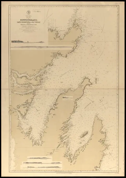
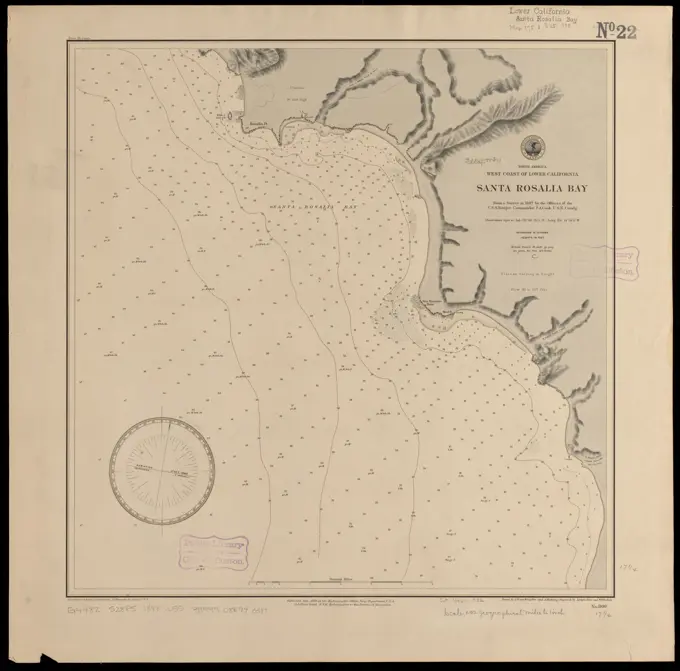
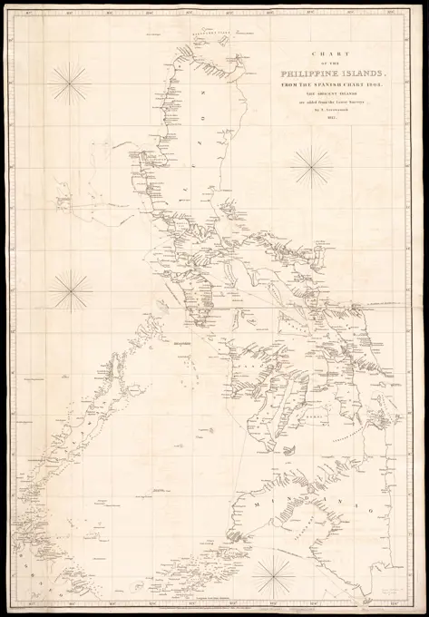
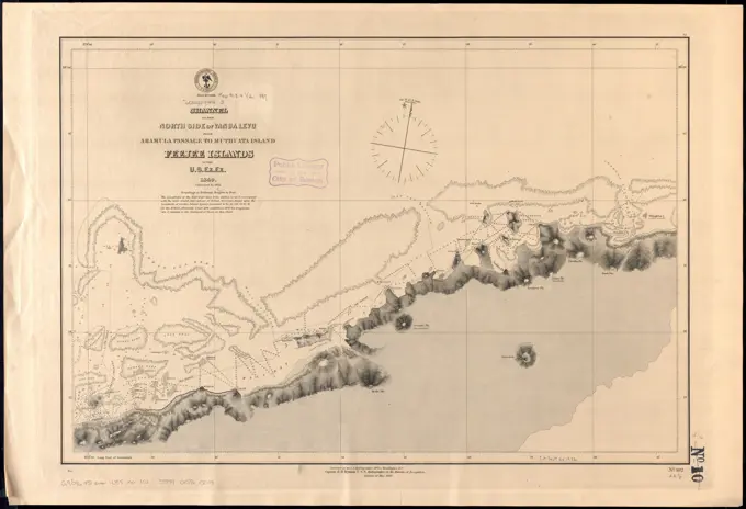
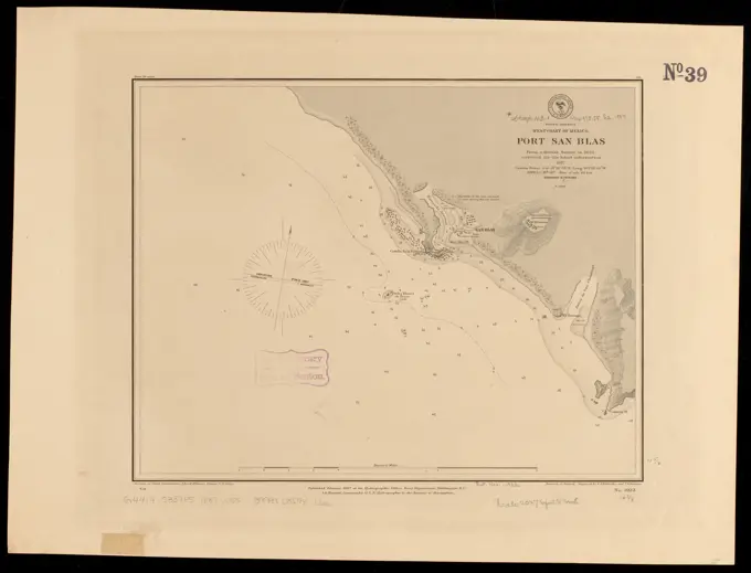
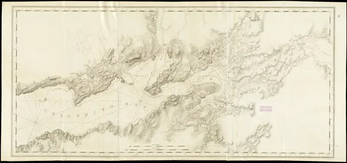
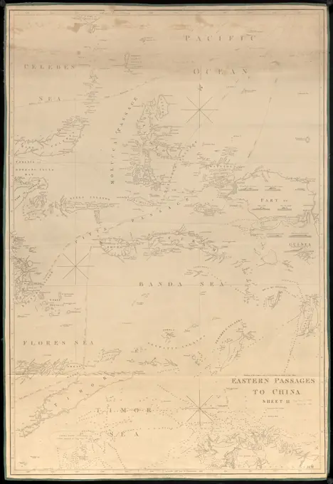
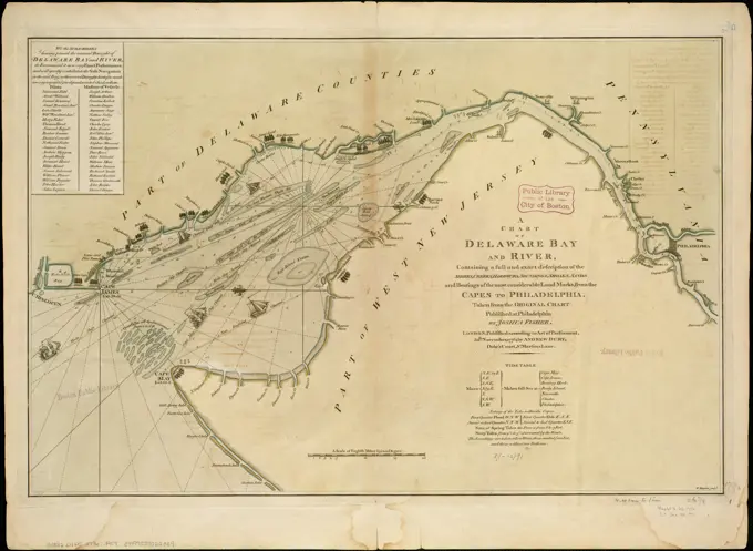
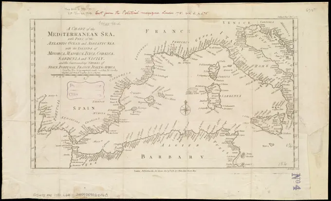
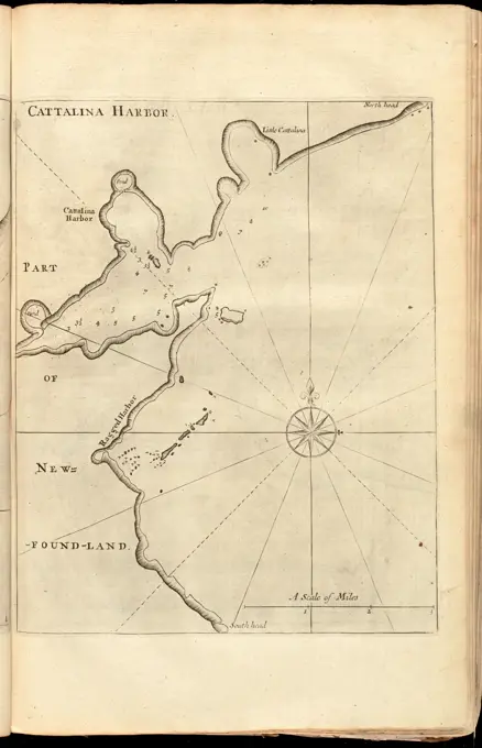
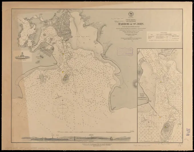
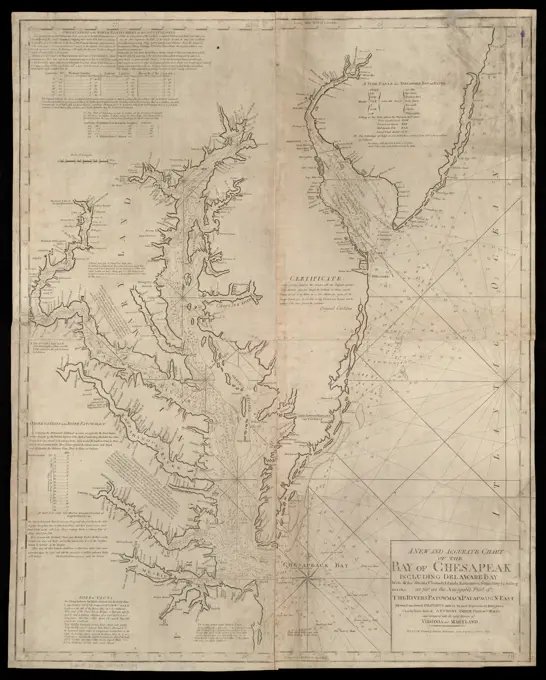
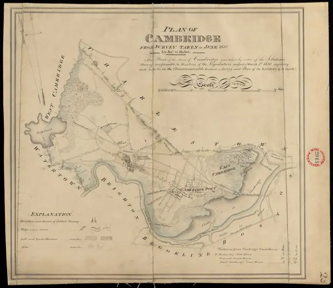
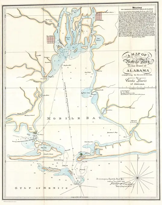
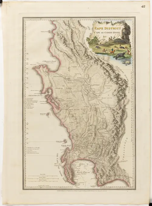
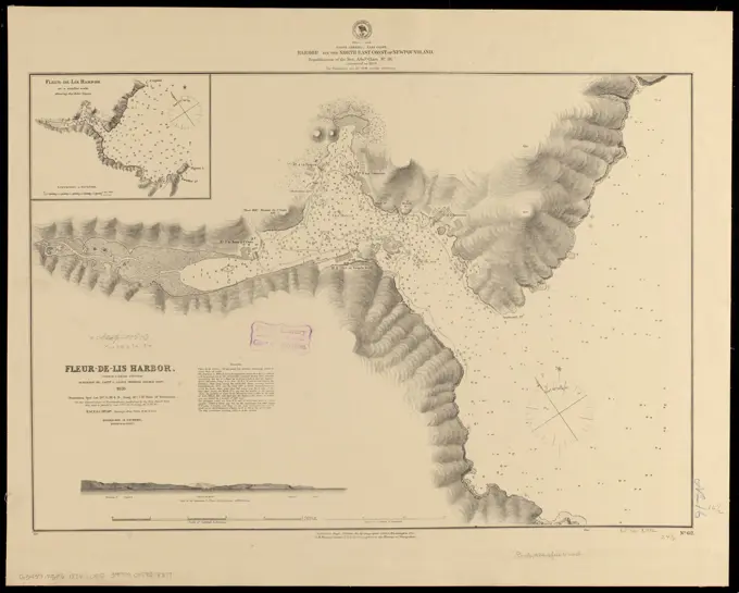
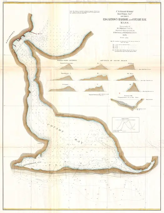
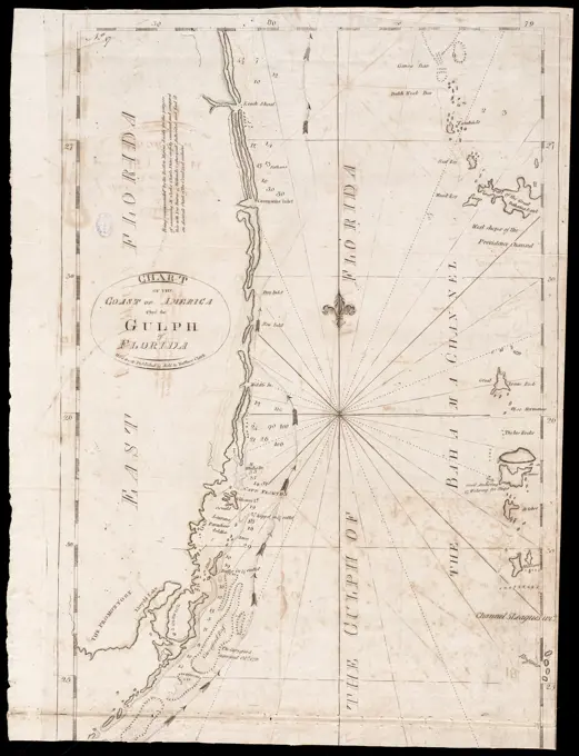
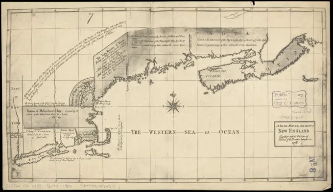
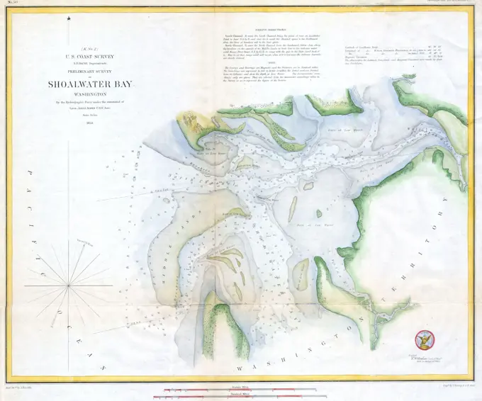
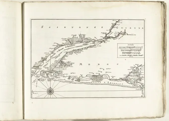
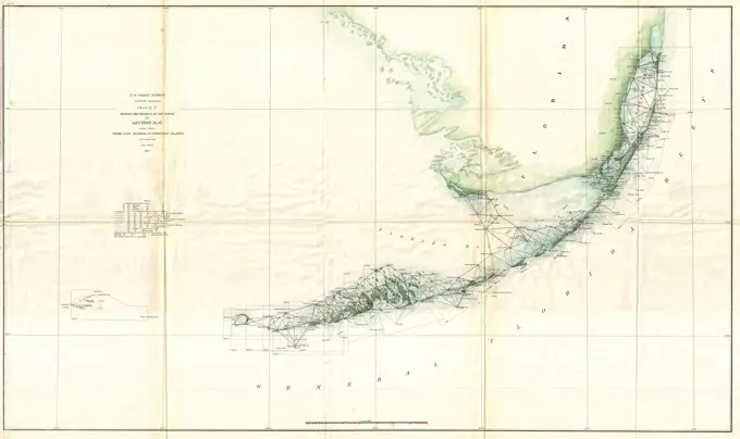
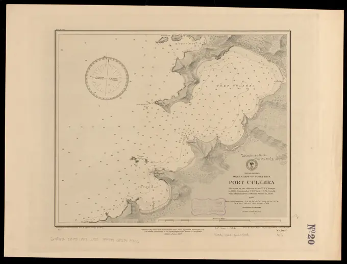
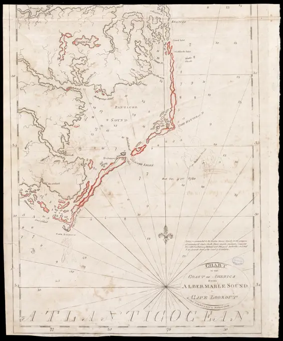
Detailed nautical charts depicting various coastal and harbor regions, including Orange Harbour in Chile and the River Min in China, featuring depths, soundings, and relief representations.

A map of the extremity of Cape Cod : including the townships of Provincetown & Truro: with chart of their sea coast and of Cape Cod Harbour, State of Massachusetts , Cape Cod Mass., Maps, Provincetown Mass., Maps, Truro Mass. : Town, Maps Norman B. Leventhal Map Center Collection
The Bermudas, or Summer's Islands , Shipwrecks, Bermuda Islands, Maps, Early works to 1800, Nautical charts, Bermuda Islands, Early works to 1800, Bermuda Islands, Maps, Early works to 1800 Norman B. Leventhal Map Center CollectionNorth America, east coast of Newfoundland, Cape Bonavista to Bay Bulls including Trinity, & Conception Bays : from Brit. surveys 1867-1871 ; republication of Brit. Admty. chart no. 296, corrected to 1874 , Coasts, Newfoundland and Labrador, Maps, Nautical charts, Newfoundland and Labrador, Bonavista Bay, Nautical charts, Newfoundland and Labrador, Trinity Bay, Nautical charts, Newfoundland and Labrador, Conception Bay, Bonavista Bay N.L., Maps, Trinity Bay N.L., Maps, Conception Bay N.L., Maps Norman B. Leventhal Map Center CollectionNorth America, west coast of lower California, Santa Rosalia Bay : from a survey in 1887 by the officers of the U.S.S. Ranger, Commander F.A. Cook, U.S.N., comdg , Nautical charts, Mexico, Santa Rosalía Bay, Santa Rosalía Bay Mexico, Maps Norman B. Leventhal Map Center CollectionChart of the Philippine Islands, from the Spanish chart 1808 : the adjacent islands are added from the latest surveys , Nautical charts, Philippines, Philippines, Maps Norman B. Leventhal Map Center CollectionChannel on the north side of Vanua Levu from Aramula Passage to Muthuata Island, Feejee Islands , Vanua Levu Fiji, Maps, Nautical charts, Fiji, Vanua Levu Norman B. Leventhal Map Center CollectionNorth America, south coast of Newfoundland : Devil Bay to Knife Bay : from a British survey in 1872 & 1873 ; republication of Brit. Admty. chart no. 300 , Coasts, Newfoundland and Labrador, Maps, Nautical charts, Newfoundland and Labrador, Maps, Newfoundland and Labrador, Maps Norman B. Leventhal Map Center CollectionNorth America, south coast of Newfoundland : Devil Bay to Knife Bay : from a British survey in 1872 & 1873 ; republication of Brit. Admty. chart no. 300. Relief shown by hachures and spot heights. Depths shown by soundings and form lines... Devil Bay to Knife Bay. Devil Bay to Knife Bay, Canada  , Newfoundland and Labrador  ,provinceNorth America, west coast of Mexico, Port San Blas : from a British survey in 1822, corrected for the latest information, 1887 , Harbors, Mexico, San Blas, Maps, Nautical charts, Mexico, San Blas, San Blas Mexico, Maps Norman B. Leventhal Map Center CollectionNorth America, east coast, coast of Labrador from Cape St. Charles to Sandwich Bay : from British surveys to 1882 , Coasts, Newfoundland and Labrador, Labrador, Maps, Nautical charts, Newfoundland and Labrador, Labrador, Labrador N.L., Maps Norman B. Leventhal Map Center CollectionChart of the coast of America from Cape Fear to Cape Look Out , Nautical charts, North Carolina, Early works to 1800, Coasts, North Carolina, Maps, Early works to 1800, Atlantic Coast N.C., Maps, Early works to 1800 Norman B. Leventhal Map Center CollectionIsland of Yendua, Feejee Group ; Nucumurry Harbour, west end of Vanua Levu ; Wailea Bay, north side of Vanua Levu , Yandua Island Fiji, Maps, Vanua Levu Fiji, Maps, Nautical charts, Fiji, Vanua Levu, Nautical charts, Fiji, Yandua Island Norman B. Leventhal Map Center CollectionChignecto Bay and vicinity , Nautical charts, Chignecto Isthmus N.B. and N.S., Early works to 1800, Chignecto Isthmus N.B. and N.S., Maps, Early works to 1800 Norman B. Leventhal Map Center CollectionPlan of Eastham and Orleans, made by John G. Hales, dated 1831.... , Massachusetts  , Barnstable  ,county   , Eastham Massachusetts  , Barnstable  ,county   , OrleansPlan of Watertown made by John G. Hales, dated June 1830.... , Massachusetts  , Middlesex  ,county   , WatertownTopographical map of the country between the Mohawk River and Wood Creek: from an actual survey taken in November, 1758 Documentary history of the State of New-York Cartographic. Maps, Facsimiles. 1859 - 1859. Lionel Pincus and Princess Firyal Map Division. Mohawk River (N.Y.), Oneida County (N.Y.), Fort Stanwix (Rome, N.Y.)Eastern passages to China. Shows Banda Sea, parts of Timor Sea, Flores Sea, and various ship routes in the region of Indonesia. Relief shown by hachures. Depths shown by soundings. "Corrections to 1849." Includes views: Po. Popa -- Po. Pisang -- Kekik --Lawn Isles -- Fairway Rock -- Xulla Bessey -- Lomblen Peak.... , Banda, Laut Celebes Sea Timor SeaThe harbor of Hyannis , Nautical charts, Massachusetts, Hyannis Harbor, Harbors, Massachusetts, Hyannis, Maps, Hyannis Harbor Mass., Maps, Hyannis Mass., Maps Norman B. Leventhal Map Center CollectionMap of the Fort at Siara, ca. 1636-1644, 1645 - 1647 Map of the fort at Siara or Ceará (Fortaleza), ca. 1636-1644. Plate no. 25 in a series of 55 performances from the trip to and the stay in Brazil by Count Johan Maurits van Nassau in the years 1636-1644. print maker: Northern Netherlandspublisher: Amsterdam paper etching / engraving  Fortaleza Map of the fort at Siara or Ceará (Fortaleza), ca. 1636-1644. Plate no. 25 in a series of 55 performances from the trip to and the stay in Brazil by Count Johan Maurits van Nassau in the years 1636-1644. print maker: Northern Netherlandspublisher: Amsterdam paper etching / engraving  FortalezaA chart of Delaware Bay and River, containing a full and exact description of the shores, creeks, harbours, soundings, shoals, sands, and bearings of the most considerable land marks, from the capes to Philadelphia. Oriented with north to the right. Depths shown by soundings. Shows ship channels. Includes list of subscribers and "Tide table."... , Delaware River Delaware BayThe Roads of Toulon, with the adjacent country , Toulon France, Maps, Early works to 1800 Norman B. Leventhal Map Center CollectionA chart of the Mediterranean Sea, with part of the Atlantic Ocean and Adriatic Sea, with the islands of Minorca, Majorca, Ivica, Corsica, Sardinia and Sicily and the surrounding shores of Spain, Portugal, France, Italy & Africa , Mediterranean Sea, Maps, Early works to 1800 Norman B. Leventhal Map Center CollectionHyannis Harbor, Massachusetts. Depths shown by soundings. "No. 247" in margins. "Published November, 1894, W.W. Duffield, Superintendent. Verified: B.A. Colonna ..." Includes information on buoys, elevations, soundings, tides, lights, and weather signal stations.... , Massachusetts  , Barnstable  ,county   , Hyannis HarborNorth America, west coast of lower California, Playa Maria Bay to Rosalia Point : from a survey in 1887 by the officers of the U.S.S. Ranger, Commander F.A. Cook, U.S.N., comdg , Coasts, Mexico, Baja California State, Maps, Nautical charts, Mexico, Baja California State, Baja California Mexico : State, Maps Norman B. Leventhal Map Center CollectionCattalina Harbor , Harbors, Newfoundland and Labrador, Catalina, Early works to 1800, Nautical charts, Newfoundland and Labrador, Catalina, Early works to 1800 Norman B. Leventhal Map Center CollectionNorth America, New Brunswick, Harbor of St. John : from the latest British surveys , Harbors, New Brunswick, Saint John, Nautical charts, New Brunswick, Saint John, Saint John N.B., Maps Norman B. Leventhal Map Center CollectionA chart of South Carolina and Georgia , Coasts, Georgia, Maps, Early works to 1800, Coasts, South Carolina, Maps, Early works to 1800, Georgia, Maps, Early works to 1800, South Carolina, Maps, Early works to 1800, Charleston S.C., Maps, Early works to 1800 Norman B. Leventhal Map Center CollectionA chart of the Mediterranean Sea, with part of the Atlantic Ocean and Adriatic Sea, with the islands of Minorca, Majorca, Ivica, Corsica, Sardinia and Sicily and the surrounding shores of Spain, Portugal, France, Italy & Africa , Mediterranean Sea, Maps, Early works to 1800 Norman B. Leventhal Map Center CollectionSouth America, west coast, ports and anchorages on the coast of Chile : special plans to chart no. 752, Santa Maria Id. & Coliumo Bay, from British surveys in 1835 ; Port & River Lebu and Port Yañez from Chilean surveys in 1862 & 66 , Coasts, Chile, Maps, Harbors, Chile, Lebu, Nautical charts, Chile, Santa María Island Biobío, Nautical charts, Chile, Coliumo Bay, Nautical charts, Chile, Yane Harbor, Santa María Island Biobío, Chile, Maps, Coliumo Bay Chile, Maps, Puerto Yane Chile, Maps, Lebu River Chile, Maps Norman B. Leventhal Map Center CollectionHarbors on the s.w. coast of Newfoundland : republication of Brit. Admty. chart no. 743 , Coasts, Newfoundland and Labrador, Maps, Nautical charts, Newfoundland and Labrador, Codroy Road, Nautical charts, Newfoundland and Labrador, St. George's Harbour, Codroy Road N.L., Maps, St. George's Harbour N.L., Maps Norman B. Leventhal Map Center CollectionChart of the west coast of Sumatra between Rigas and Diah from actual survey. Relief shown by hachures. Depths shown by soundings. Insets: Plan of Analaboo Anchorage -- Plan of Rigas Bay -- Plan of the passage between Pulo Riah and the main. Includes remarks and 5 coastal views.... , Indonesia  , Sumatra  ,islandDominica from an actual survey compleated in the year 1773 , Dominica, Maps, Early works to 1800 Norman B. Leventhal Map Center CollectionDominica from an actual survey compleated in the year 1773. Relief shown by hachures; depths by soundings. Shows settlements, forested areas, hot springs, salt pans, parishes, Carib lands, anchorages, etc. "Printed for Robt. Sayer, Map and Printseller, no. 53 in Fleet Street, as the Act directs 20 Feby. 1775." Appears in the author's West-India atlas. London : Robert Sayer and John Bennett, 1783 i.e. 1788. Prime meridians: London and Ferro. Cataloging, conservation, and digitization made possible in part by The National Endowment for the Humanities: Exploring the human endeavor.... , DominicaOrange Harbour, Tierra del Fuego , Nautical charts, Chile, Orange Bay, Orange Bay Chile, Maps Norman B. Leventhal Map Center CollectionPort Mills : Port Mansfield ; Gambier Harbour , Nautical charts, Nova Scotia, Early works to 1800, Nova Scotia, Maps, Early works to 1800 Norman B. Leventhal Map Center CollectionSooke sheet, Vancouver Island, British Columbia , Sooke Region B.C., Maps, Vancouver Island B.C., Maps Norman B. Leventhal Map Center CollectionA2. Constantinopel. Kiepert, Richard, 1846-1915. Cartographic. Maps. 1902 - 1916. Lionel Pincus and Princess Firyal Map Division. Turkey, Turkey, MapsA new and accurate chart of the Bay of Chesapeak including Delaware Bay with all the shoals, channels, islands, entrances, soundings, & sailing marks as far as the navigable part of the rivers Patowmack Patapsco & N. East. Depths shown by soundings. Includes notes, tables and certificate. In John Norman's American pilot. Boston : John Norman, 1794.... , Delaware Bay Chesapeake BayIsland of Teneriffe; View of the town & road of Santa-Cruz Cartographic. Prints, Maps. 1745 - 1747. Rare Book Division. Tenerife (Canary Islands), Santa Cruz de Tenerife (Canary Islands)South extreme of America, Wollaston Islands : from British surveys corrected to 1878 , Nautical charts, Chile, Gretton Bay, Nautical charts, Chile, Rada Norte, Nautical charts, Chile, Scourfield Bay, Nautical charts, Chile, Hately Bay, Nautical charts, Chile, Middle Cove, Wollaston Island Chile, Maps, Gretton Bay Chile, Maps, Rada Norte Chile, Maps, Scourfield Bay Chile, Maps, Hately Bay Chile, Maps, Middle Cove Chile, Maps Norman B. Leventhal Map Center CollectionCollins' environs of Sebastopol, showing the position of the investing armies and also the plan of the battle-field of Alma. Relief shown by hachures. Shows troop positions and battlefield notes.... , Ukraine  , Sevastopol'A chart of the coast of America from Wood Island to Good Harbour from Hollands surveys , Coasts, Maine, Early works to 1800, Nautical charts, Maine, Early works to 1800, Maine, Maps, Early works to 1800 Norman B. Leventhal Map Center CollectionHarbors and anchorages on the eastern coast of Newfoundland : republication of British Adm. charts no. 294 & 489 , Coasts, Newfoundland and Labrador, Maps, Nautical charts, Newfoundland and Labrador, Greenspond Island, Nautical charts, Newfoundland and Labrador, Valleyfield Harbour, Nautical charts, Newfoundland and Labrador, Catalina Harbour, Greenspond Island N.L., Maps, Valleyfield Harbour N.L., Maps, Catalina Harbour N.L., Maps Norman B. Leventhal Map Center CollectionA new and accurate chart of the Bay of Chesapeak including Delaware Bay with all the shoals, channels, islands, entrances, soundings, & sailing marks as far as the navigable part of the rivers Patowmack Patapsco & N. East. Depths shown by soundings. Includes notes, tables and certificate. In The American pilot. Boston : Andrew J. Allen, 1816.... , Delaware Bay Chesapeake BayRed Sea, Safájah Island anchorages : from a British survey in 1872 , Safaga Island Egypt, Maps, Navigation, Egypt, Safaga Island Norman B. Leventhal Map Center CollectionPlan of Cambridge made by John G. Hales, dated June 1830.... , Massachusetts  , Middlesex  ,county   , CambridgeCentral America, west coast of Costa Rica, Murcielago Bay : from a survey in 1885 by the officers of the U.S.S. Ranger, Commander C.E. Clark, U.S.N., comdg , Nautical charts, Costa Rica, Murcielago Bay, Murcielago Bay Costa Rica, Maps, Murcielago Islands Costa Rica, Maps Norman B. Leventhal Map Center CollectionTopographical map of Blue Hills Reservation , Recreation areas, Massachusetts, Maps, Blue Hills Reservation Mass., Maps Norman B. Leventhal Map Center Collection1886 Lewis Map of Mobile Bay, AlabamaA plan of the city and harbour of the Havana situated on the island of Cuba. Oriented with north to the bottom. Depths shown by soundings. Havana's strategic importance as a naval center is readily apparent on this mid-18th-century manuscript map. The center of focus is the natural harbor, with numerous depth soundings in its entrance indicating the safest passage into the harbor proper. Not only is the city fortified by a wall on its western (right) edge, but there are also six forts in the vicinity. Surrounding the city are agricultural settlements that most likely furnished provisions for the Spanish fleets returning to Europe. Unlike most maps, this one is not oriented with north at the top of the page, rather north is at the bottom, emphasizing the approach of the Spanish ships to the harbor by sea. Drawn by an unnamed British map maker, this map reflects British interest in developing trade with Cuba during the mid-18th century, which resulted in Havana's capture by the British iCape District, Cape of Good Hope ,. Robert E. Diefenbach Map CollectionNorth America, east coast, harbor on the north east coast of Newfoundland : republication of the Brit. Admty. chart no. 281, corrected to 1874 , Nautical charts, Newfoundland and Labrador, Fleur de Lys Harbour, Fleur de Lys Harbour N.L., Maps Norman B. Leventhal Map Center CollectionNorth America, east coast, harbor on the north east coast of Newfoundland : republication of the Brit. Admty. chart no. 281, corrected to 1874. Relief shown by hachures and spot heights. Depths shown by soundings. Inset: Fleur-de-Lis Harbor on a smaller scale showing the outer capes... Harbor on the north east coast of Newfoundland Fleur-de-Lis Harbor (French fishing station) surveyed by Captn. G. Cloue imperial French Navy 1859. Harbor on the north east coast of Newfoundland Fleur-de-Lis Harbor (French fishing station) surveyed by Captn. G. Cloue imperial French Navy 1859, Canada  , Newfoundland and Labrador  ,province   , Fleur de LysCoast of Massachusetts from Cape Ann to Manomet Point, including northern tip of Cape Cod , Coasts, Massachusetts, Maps, Early works to 1800, Nautical charts, Massachusetts, Early works to 1800, Massachusetts, Maps, Early works to 1800 Norman B. Leventhal Map Center CollectionGrundriss des nordlichen Theils der Neujorks Insel nebst den am 16. Novbr. 1776. eroberten Fort Washington nun das Fort Knyphausen genannt und dem Fort Lee.... , New York  , New York Fort Washington  ,historical1871 U.S. Coast Survey Map or Chart of Edgartown Harbor, Martha's Vineyard, MassachusettsMap of the battle field of Spottsylvania C.H : showing the field of operations of the Army of the Potomac commanded by Maj. Gen. George G. Meade U.S.A., from May 8th to 21st, 1865 i.e. 1864 , Spotsylvania Court House, Battle of, Va., 1864, Maps, 1864 Norman B. Leventhal Map Center CollectionSketch of the narrows in Boston Harbor , Boston Harbor Mass., Maps Norman B. Leventhal Map Center CollectionCoast of New Hampshire and Massachusetts from Great Boars Head to Marblehead Harbor , Coasts, Massachusetts, Essex County, Maps, Early works to 1800, Coasts, New Hampshire, Rockingham County, Maps, Early works to 1800, Nautical charts, Massachusetts, Essex County, Early works to 1800, Essex County Mass., Maps, Early works to 1800, Rockingham County N.H., Maps, Early works to 1800, Atlantic Coast N.H., Maps, Early works to 1800 Norman B. Leventhal Map Center CollectionChart of the coast of America thro' the Gulph of Florida , Nautical charts, Florida, Straits of, Early works to 1800, Coasts, Florida, Maps, Early works to 1800, Atlantic Coast Fla., Maps, Early works to 1800, Gulf Coast Fla., Maps, Early works to 1800 Norman B. Leventhal Map Center CollectionSouth America, west coast, Chile, Coronel, Lota & Colcura anchorages in Arauco Bay : from a Chilean government survey in 1878 , Coasts, Chile, Maps, Nautical charts, Chile, Coronel Bay, Nautical charts, Chile, Lota Bay, Nautical charts, Chile, Colcura Cove, Coronel Bay Chile, Maps, Lota Bay Chile, Maps, Colcura Cove Chile, Maps Norman B. Leventhal Map Center CollectionCarta del nuovo continente : nella maggior sua lunghezza diametrale dal fiume della Plata fin oltre il lago degli Assiniboils. Relief shown pictorially. "C. II."... , North and Central America South America Mesoamerica  ,area  North America  ,area  South America AmericaFrom Monomoy and Nantucket Shoals to Muskeget Channel, Mass , Nautical charts, Massachusetts, Nantucket Sound, Nantucket Sound Mass., Navigation, Maps Norman B. Leventhal Map Center CollectionA small map of the sea coast of New England together with the outlines of several of the provinces lying thereon, 1738 , Coasts, New England, Maps, Coasts, Nova Scotia, Maps, New England, Maps, Nova Scotia, Maps Norman B. Leventhal Map Center Collection1853 U.S.C.S. Map of Shoalwater Bay, WashingtonPlan of Otisfield, made by Oliver Prescott, Jr., dated 1794-5, showing Shepard's Grant i.e. Phillips Gore. ,. Massachusetts. Office of the Secretary of StateCharleston Harbor and its approaches showing the positions of the Rebel batteries , Charleston Harbor S.C., History, 19th century, Maps, Charleston Region S.C., History, 19th century, Maps Norman B. Leventhal Map Center CollectionPequot War battle sites, frontispiece Cartographic. Maps, Frontispieces. 1897. General Research Division. Pequot War, 1636-1638, Indians of North America , Wars , 1600-1750Collins' environs of Sebastopol, showing the position of the investing armies and also the plan of the battle-field of Alma , Crimean War, 1853-1856, Maps, Alma, Battle of the, Ukraine, 1854, Maps, Sevastopolʹ Ukraine, History, Siege, 1854-1855, Maps Norman B. Leventhal Map Center CollectionCarta particolare dell' rio d'Amazone con la costa sin al fiume Maranhan , Coasts, Brazil, North, Maps, Early works to 1800, Coasts, Brazil, Maranhío, Maps, Early works to 1800, Nautical charts, Early works to 1800 Norman B. Leventhal Map Center CollectionNautical chart of Boston Harbor, Massachusetts, issued by the U.S. Coast Survey in 1857. The map measures 72 x 90 cm and is presented on a sheet that measures 78 x 96 cmWest Indies, Bahamas, Port Nelson, Rum Cay : from a survey in 1886 by the officers of the U.S. Fish Commission Steamer Albatross, Lieutenant-Commander Z. L. Tanner, U.S.N. comdg , Nautical charts, Bahamas, Port Nelson, Port Nelson Bahamas, Maps Norman B. Leventhal Map Center CollectionPreliminary chart of Eagle Harbor, Lake Superior : from surveys under the direction of the Topographical Bureau of the War Department, in obedience to acts of Congress requiring the Survey of the north and north western lakes , Nautical charts, Michigan, Eagle Harbor Bay, Nautical charts, Superior, Lake, Eagle Harbor Mich., Maps, Eagle Harbor Mich. : Bay, Maps Norman B. Leventhal Map Center CollectionDominion of Canada, Gulf of Saint Lawrence, Merigomish Harbor (Nova Scotia) : from a British survey in 1842 , Nautical charts, Nova Scotia, Merigomish Harbour, Merigomish Harbour N.S., Maps Norman B. Leventhal Map Center CollectionMap of the French West Coast with the mouth of the Garonne and Dordogne, ca. 1702, 1702 - 1703 print Map of the French West Coast with the mouth of the Garonne and Dordogne. Marked at the bottom right: X. Part of the second of two parts of the print work: Les Costes de France et d'Espagne (or part 14 of: Les Forces de l'Europe, Asie, Afrique et Amerique), published ca. 1702. The Prent work consists of a total of 43 marked plates from the coast of France and Spain, in the context of the Spanish War of Succession. These plates were copied to anonymous French plates originally published by Nicolas de Fer in Paris. Title and inscriptions in the album in French. print maker: Northern Netherlandspublisher: Amsterdam paper etching maps of separate countries or regions FranceCharleston Harbor and its approaches showing the positions of the Rebel batteries , Charleston Harbor S.C., History, 19th century, Maps Norman B. Leventhal Map Center CollectionCharleston Harbor and its approaches showing the positions of the Rebel batteries. Another issue. Shows roads, railroads, houses, vegetation, a street plan of Charleston, drainage, soundings, and shoals. Enlarged issue covering all of James Island and indicating 1/2-mile concentric circles centered on St. Michaels, Charleston, "first and second lines of Rebel defences," positions occupied by the Union Army and Navy, and "Rebel batteries in possession of National forces and batteries still held by the Rebels on Sept. 7th 1863." Description derived from published bibliography.... , South Carolina  , Charleston  ,county   , Charleston Harbor  ,baySouth America, west coast : republication of Brit. Admty. chart no. 1286, with additions to 1876 , Coasts, Chile, Maps, Nautical charts, Chile, Biobío Region, Biobío Chile : Region, Maps Norman B. Leventhal Map Center CollectionWest Indies, ports on the north and west coasts of Haiti : from the most recent surveys. Relief shown by hachures. Depths shown by soundings... Ports on the north and west coasts of Haiti. Ports on the north and west coasts of Haiti, Haiti  , Artibonite  , Saint-Marc Haiti  , Ouest  , Petit-Goâve Haiti  , Nord-Ouest  , Port-de-Paix Haiti  , Département du Nord Baie Fond LagrangeMaps illustrating cruises of John Paul Jones in British waters : Great Britain and Ireland , Bon Homme Richard Ship, History, Naval, Maps, Ranger Ship, History, Naval, Maps, Naval battles, Great Britain, Maps, British Isles, History, Naval, 18th century, Maps, Great Britain, History, Naval, 18th century, Maps, United States, History, Revolution, 1775-1783, Naval operations, Maps, Jones, John Paul, 1747-1792, 1778-1780 Norman B. Leventhal Map Center CollectionDominion of Canada, Cape Breton Island, Sydney Harbor : from a British survey in 1849. Relief shown by shading, form lines and spot heights. Depths shown by soundings and form lines.... , Canada  , Nova Scotia  ,province   , Sydney1859 U.S. Coast Survey Triangulation Map of the Florida KeysThe Dutch colony of the Cape of Good Hope , Cape of Good Hope South Africa, Maps, Early works to 1800 Norman B. Leventhal Map Center CollectionChart of the Streights of Belle Isle. Title from Wheat & Brun. Depths shown by soundings. In Norman's American pilot. Boston : John Norman, 1794... Bay of Fundy. Bay of Fundy, Canada  , Newfoundland and Labrador  ,province   , Belle Isle, Strait of Canada  , Saint Lawrence, Gulf ofLouisiana : Bonnet Carre sheet. Relief shown by contours, isolines and spot heights. Surveyed in 1890. Contour interval 5 feet. Henry Gannett, chief topographer; R.U. Goode, geographer in charge; triangulation by U.S. Coast and Geodetic Survey; topography by A.E. Wilson, under the direction of H.L. Baldwin Jr... Bonnet Carre sheet. Bonnet Carre sheet, LouisianaSt. Christophers or St. Kitts. Relief shown by hachures. Depths shown by soundings. Cadastral map. Prime meridian: London and Ferro. Includes statistical information, profile of Nevis, and inset "Nevis, by Thomas Jefferys." Cataloging, conservation, and digitization made possible in part by The National Endowment for the Humanities: Exploring the human endeavor. Cataloging, conservation, and digitization made possible in part by The National Endowment for the Humanities: Exploring the human endeavor.... , Saint Kitts and Nevis  , Saint Kitts  ,island1784 Tiefenthaler Map of the Ganges and Ghaghara Rivers, IndiaCentral America, west coast of Costa Rica, Port Culebra , Nautical charts, Costa Rica, Culebra Bay, Culebra Bay Costa Rica, Maps Norman B. Leventhal Map Center CollectionA chart of South Carolina and Georgia , Coasts, Georgia, Maps, Early works to 1800, Coasts, South Carolina, Maps, Early works to 1800, Georgia, Maps, Early works to 1800, South Carolina, Maps, Early works to 1800, Charleston S.C., Maps, Early works to 1800 Norman B. Leventhal Map Center CollectionLake George, Fort Ticonderoga and vicinity Cartographic. Maps. 1850. Lionel Pincus and Princess Firyal Map Division. Lake George (N.Y.), Fort Ticonderoga (N.Y.)A survey of Lake Champlain: including Lake George, Crown Point, and St. John Brasier, William (British artist, active 18th century). Cartographic. Maps. 1776-08-05. Lionel Pincus and Princess Firyal Map Division. Valcour Island, Battle of, N.Y., 1776 , Maps, Champlain, Lake , Maps, Champlain, Lake , History , Maps, George, Lake (N.Y. : Lake) , MapsNieu Nederlandt, 1841. Map published in New York, N.Y., created by Cornelis Hendricxz. Early work related to New Netherland and the Northeastern States, measuring 64 x 46 cm on a sheet of 50 x 75 cmChart of the coast of America from Albermarle Sound to Cape Lookout , Nautical charts, North Carolina, Early works to 1800, Coasts, North Carolina, Maps, Early works to 1800, Atlantic Coast N.C., Maps, Early works to 1800 Norman B. Leventhal Map Center Collection1853 U.S.C.S. Map of Timbalier Bay, LouisianaRockport Harbor, Massachusetts , HarborsCarta della Grecia antica secondo le osservazioni di Sir William Gell per servire alla traduzione di Pausania di A. Nibby. Relief shown by hachures. From A. Nibby's Descrizione della Grecia di Pausania nuovamente dal testo greco. Roma: Presso Vincenzo Poggioli Stampatore della R.C.A., 1817-18.... , GreeceNew Jersey, Double Page Sheet No. 16 Map of Egg Harbor Cartographic. Atlases, Maps. 1884 - 1889. Lionel Pincus and Princess Firyal Map Division. New Jersey, Geology , New JerseyRepublic of Liberia - Liberian coastal area, circa 1853Port Orchard, Puget Sound, Washington Ter.West Indies, island of Guadeloupe, Port du Moule : from a French survey in 1868 , Nautical charts, Guadeloupe, Le Moule, Le Moule Guadeloupe, Maps Norman B. Leventhal Map Center CollectionPlan of Brookline made by John G. Hales, dated August 1830 ,. Massachusetts. Office of the Secretary of State