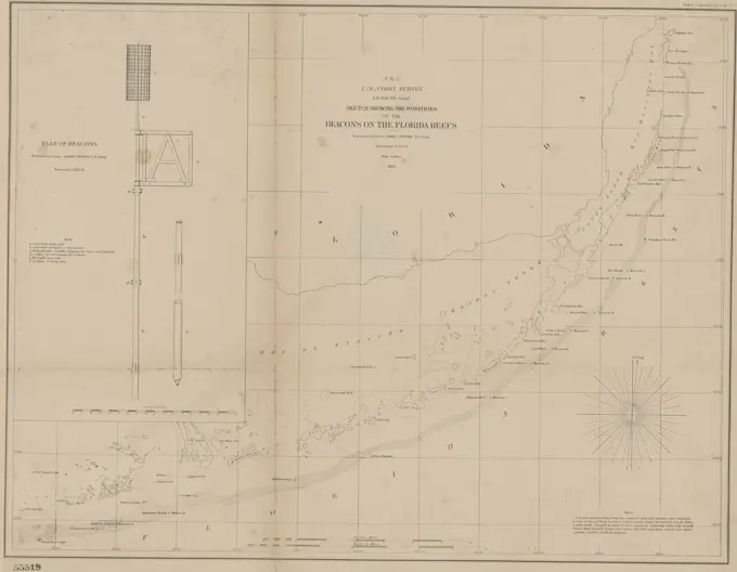
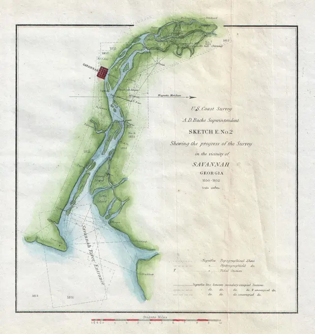
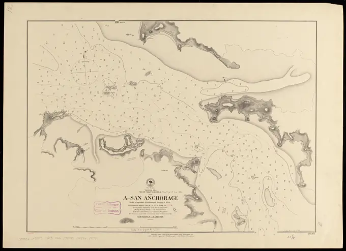
Nautical Maps of North American Coastlines

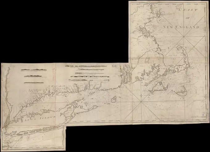
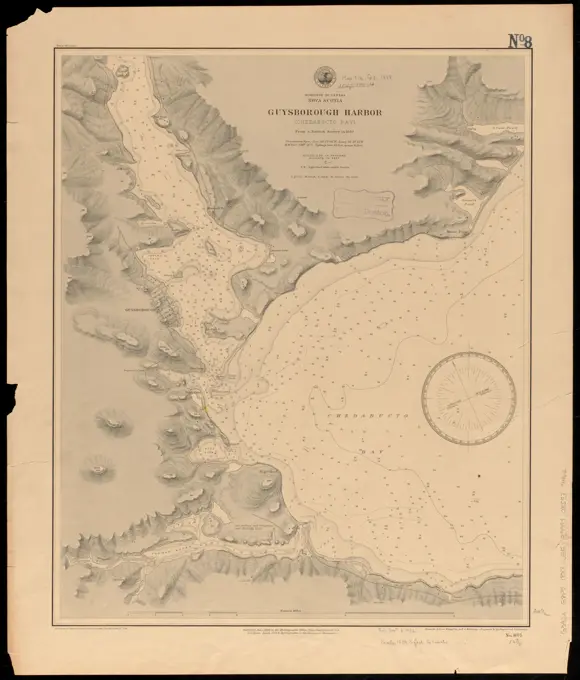
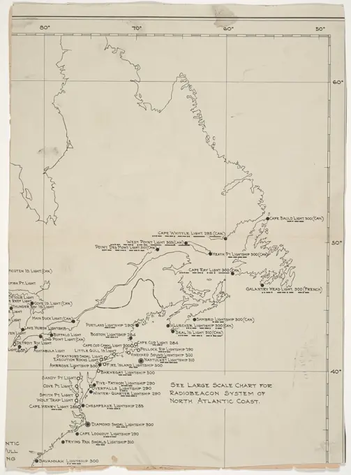
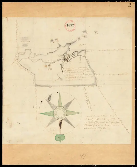
Detailed nautical charts depicting various regions of Newfoundland and Nova Scotia, highlighting maritime navigation routes and geographical features.

Nantucket Harbor, Massachusetts , Nautical charts, Massachusetts, Nantucket Harbor, Nantucket Harbor Mass., Maps Norman B. Leventhal Map Center Collection
From Muskeget Channel to Buzzard's Bay and entrance to Vineyard Sound, Mass , Nautical charts, Massachusetts, Atlantic Coast, Nautical charts, Massachusetts, Buzzards Bay Bay, Nautical charts, Massachusetts, Vineyard Sound, Nautical charts, Massachusetts, Nantucket Sound, Coasts, Massachusetts, Maps, Atlantic Coast Mass., Maps, Buzzards Bay Mass. : Bay, Maps, Vineyard Sound Mass., Maps, Nantucket Sound Mass., Maps, Martha's Vineyard Mass., Maps, Elizabeth Islands Mass., Maps, Massachusetts, Maps Norman B. Leventhal Map Center CollectionFrom Muskeget Channel to Buzzard's Bay and entrance to Vineyard Sound, Mass. Also covers Martha's Vineyard and the Elizabeth Islands. Relief shown by shading and landform drawings. Depths shown by soundings and contours. Triangulation, topography, and hydrography conducted between 1844 and 1857. Includes 7 views of shorelines as seen from the ocean.... , Massachusetts  , Buzzards Bay Massachusetts  , Dukes  ,county   , Nantucket Sound  ,bay  Massachusetts  , Dukes  ,county   , Elizabeth Islands  ,area  Vineyard SoundA chart of Delaware Bay with soundings and nautical observations, created by Joseph F.W. Des Barres in 1779. Issued in London, this map measures 74 x 52 cm and features early nautical charts of Delaware Bay, covering areas in Delaware and New JerseyWest Indies, island of Guadeloupe, Port du Moule : from a French survey in 1868. Relief shown by shading, form lines and spot heights. Depths shown by soundings and isolines. "Cor. 1889.7.".. Port du Moule. Port du Moule, Guadeloupe  ,territory   , Grande-Terre  ,island   , Le MouleChart of the coast of Quebec from the Riviere St. Jean to Grand Hermine Bay. 2nd state. Title from published bibliography. Appears in the author's Atlantic Neptune. London : J.F.W. Des Barres, 1777-1781.... , Canada  , Saint Lawrence, Gulf of Saint Lawrence River  ,riverNorth Atlantic Ocean, Bermuda Islands : from British surveys to 1926, with additions and corrections to 1936 , Navigation, Bermuda Islands, Bermuda Islands, Maps Norman B. Leventhal Map Center CollectionCarte de la portion S.O de l'ile de la Guadeloupe : levee en 1842. Relief shown by shading, hachures and spot heights. Published in: Voyage geologique aux Antilles et aux Iles de Teneriffe et de Fogo / Charles Joseph Sainte-Claire Deville. Inset: Triangulation. In upper left margin: Voyage geologique aux Antilles." In upper right margin: Guadeloupe - planche XVI. Boston Public Library copy includes manuscript inscription by the author to Captain Duperrey.... , Guadeloupe  ,territorySouth America, west coast : republication of Brit. Admty. chart no. 1277, with additions to 1876. Relief shown by hachures and spot heights. Depths shown by soundings. Insets: Anchorage at Angamos Point -- Constitucion Harbor -- Bolfin or Chimba Bay -- El Cobre Bay... Bolivia & Chile, Pt. Grande to C.S. Francisco. Bolivia & Chile, Pt. Grande to C.S. Francisco, Chile  , Antofagasta  ,region   , Mejillones, Península  ,area   , Angamos, Punta  ,point  Chile  , Antofagasta  ,region   , Constitución, Caleta  ,bay  Chile  , Antofagasta  ,region   , La Chimba, Caleta  ,cove  Chile  , Antofagasta  ,region   , El Cobre, Caleta  ,cofeBay of Seven Islands , Nautical charts, Saint Lawrence River, Early works to 1800, Saint Lawrence River, Maps, Early works to 1800 Norman B. Leventhal Map Center CollectionTaputeouea or Drummond's Island, Kingsmill Group ; Peacock's anchorage at Drummond's Island, Kingsmill Group , Tabiteuea Atoll Kiribati, Maps, Nautical charts, Kiribati, Tabiteuea Atoll Norman B. Leventhal Map Center CollectionPRIMERA DEMOSTRACION DE LAS DOS COSTAS DE CALIFORNIA HECHA EN 1545. Location: MUSEO NAVAL / MINISTERIO DE MARINA. MADRID. SPAIN.Plan of Medford made by Peter Tufts, Jr., dated 1794..... , Massachusetts  , Middlesex  ,county   , MedfordWieliczka  Delineation Salisfodinae Wieliccensis Second Map of Wieliczka Saltworks Nilson, Johann Esaias (1721 1788)Carte du Nouveau Continent. Cuvier, Frederic (1773-1838). Cartographic. Prints, Illustrations. 1829 - 1832. General Research Division. Natural historySouth America, west coast, sheet 10, Bolivia and Peru, C.S. Francisco to Cape Lobos : republication of Brit. Admty. chart no. 1278, with additions to 1876 , Coasts, Chile, Maps, Nautical charts, Chile, Chile, Maps, Pisagua Bay Chile, Maps, Caleta Buena Chile, Maps, Iquique Bay Chile, Maps, Caleta Patillos Chile, Maps, Pabellón de Pica Inlet Chile, Maps, Caleta Chipana Chile, Maps Norman B. Leventhal Map Center CollectionSONDA DE CAMPECHE Y DERROTA DE LAS FLOTAS PARA VERACRUZ - SIGLO XVIII. Location: MUSEO NAVAL / MINISTERIO DE MARINA. MADRID. SPAIN.Physical and political card of Syria to serve the history of the conquests of General Bonaparte in the East. (IT)Reconnaissance map of Smith's or Blunt's Island, Washington, created by the United States Coast Survey in 1854. The map includes a sketch of Anacapa Island in the Santa Barbara Channel. It is issued in Washington, D.C., by the U.S. Coast Survey and features nautical charts of both Smith Island in Island County, Washington, and Anacapa Island in California. The document consists of 2 maps on a single sheet, measuring 15 x 23 cm or smaller, with the overall sheet size being 35 x 28 cm1852 U.S. Coast Survey Chart or Map of the Chesapeake Bay and Delaware BayNorth America, Dominion of Canada, Gulf of St. Lawrence, Magdalen Islands : from a British survey in 1833 , Nautical charts, Québec Province, Iles-de-la-Madeleine, Iles-de-la-Madeleine Québec, Maps Norman B. Leventhal Map Center CollectionPLANO DEL PUERTO DE CARTAGENA - MURCIA - AÑO 1716. Location: SERVICIO GEOGRAFICO DEL EJERCITO. MADRID. SPAIN.A topographic map of Suez, Egypt, issued between 1809 and 1828, published by Impr. impériale in Paris in 1818Chart of the Bay of Fundy from Machias Bay to 64°35' west longitude , Coasts, New Brunswick, Early works to 1800, Coasts, Nova Scotia, Early works to 1800, Nautical charts, Fundy, Bay of, Early works to 1800, Fundy, Bay of, Maps, Early works to 1800 Norman B. Leventhal Map Center CollectionMad of Madura and map of the port of Surabaya, C. van Baarsel and Son, 1817 print At the top left numbered: V.  paper engraving / etching maps of separate countries or regions Madura. SurabayaSouth America, United States of Colombia, Port Carreto : from an old Spanish plan 1886. Relief shown by hachures. Depths shown by soundings... Port Carreto. Port Carreto, Panama  , San Blas  ,special territory  Bahía de CarretoPlan of Medumcook Plantation (Friendship) surveyed by John Malcolm, dated December 28, 1795..... , Maine  , Knox  ,county   , FriendshipPlan de l'isle de la Grenade : ou sont marqués dans leur juste position, les ports et mouillages, les ville et bourgs, les rivieres, le chemins royaux et toutes les habitations suivant les lignes qui leur servent le limites distinguées par des marques particulieres qui designent les sucreries les cafféyeres &c ainsi que les differentes plantations que l'on a marqué parestime , Real property, Grenada, Maps, Early works to 1800, Grenada, Maps, Early works to 1800 Norman B. Leventhal Map Center CollectionMesstischblatt 2152 = 769 : Lebbin, 1906Dominica , Dominica, Maps, Early works to 1800 Norman B. Leventhal Map Center CollectionNorth Pacific Ocean, Loo Choo Archipelago-- Ou-sima, Hancock Bay : from British surveys in 1872 & 1882 , Nautical charts, Japan, Yakiuchi Bay, Yakiuchi Bay Japan, Maps Norman B. Leventhal Map Center CollectionMassachusetts Bay with the coast from Cape Ann to Cape Cod , Nautical charts, Massachusetts, Boston Bay, Nautical charts, Massachusetts, Cape Cod Bay, Nautical charts, Massachusetts, Massachusetts Bay, Boston Bay Mass., Navigation, Maps, Cape Cod Bay Mass., Navigation, Maps, Massachusetts Bay Mass., Navigation, Maps Norman B. Leventhal Map Center CollectionPlan of Elizabeth Islands (Naushon, Pasque, and the Wepeckalt Islands) made by Henry H. Crapo, dated 1837 ,. Massachusetts. Office of the Secretary of State1865 U.S. Coast Survey Triangulation Map of San Francisco BayPlan of Trenton surveyed by John Peters and John Peters Jr., dated 1795. ,. Massachusetts. Office of the Secretary of StatePlan of Deer Island (Isle au Haut), made by John Peters, Jr., dated May 21. 1795..... , Massachusetts  , Suffolk  ,county   , BostonDominion of Canada, Nova Scotia, Guysborough Harbor (Chedabucto Bay) : from a British survey in 1850 , Nautical charts, Nova Scotia, Chedabucto Bay, Nautical charts, Nova Scotia, Guysborough Harbour, Chedabucto Bay N.S., Maps, Guysborough Harbour N.S., Maps Norman B. Leventhal Map Center CollectionChina Sea, channel between Lamtia Island and House Hill , Coasts, China, Fujian Sheng, Maps, Nautical charts, China, Fujian Sheng, Fujian Sheng China, Maps, Nanding Island China, Maps Norman B. Leventhal Map Center CollectionPreliminary surveys of harbors on the western coast of the United States, 1854, United States Coast Survey. Point Año Nuevo anchorage, Santa Cruz harbor and vicinity., 1854., Washington, D.C. Publisher, U.S. Coast Survey. Nautical charts, California, Santa Cruz County, San Mateo County, Harbors, Año Nuevo Bay., 2 maps; 30 x 31 cm. NYPL Map Div. copy has accession no. stamped in lower left corner 546861855 Jefferson Davis Map of California from Pyramid Lake to the Sacramento RiverCartography, Italy, 18th century. Theresian map of Contra with Tignoso and Pieve di Missaglia. Ink and watercolor on paper, 72 x 48 cm.Map of a reconnaissance from Carroll Montana Ter. to the Yellowstone National Park and return by Captain William Ludlow, Corps of Engineers, Chief Engineer Dept. of Dakota, in July, August and September 1875. Relief shown by contours. Includes list of authorities.... , Montana WyomingMap of the coast of Massachusetts and Rhode Island, issued in 1872 by the United States Fish Commission. The map features nautical charts for both states, highlighting fisheries and navigation areas. It measures 48 x 96 cm on a sheet that is 53 x 105 cm. Published in Washington, D.CSouth America--west coast--Patagonia, anchorages in Wide Channel and Indian Reach : from Chilean partial surveys in 1879 , Coasts, Chile, Maps, Nautical charts, Chile, Grau Cove, Nautical charts, Chile, Elena Cove, Nautical charts, Chile, Puerto Micaela, Nautical charts, Chile, Sandy Cove, Nautical charts, Chile, Chacabuco Cove, Wide Channel Chile, Maps, Paso del Indio Chile, Maps, Grau Cove Chile, Maps, Elena Cove Chile, Maps, Puerto Micaela Chile, Maps, Sandy Cove Chile, Maps, Chacabuco Cove Chile, Maps Norman B. Leventhal Map Center CollectionMap of East - Sudbury ,. Wayland Historical Society Collection4 Kinten , Kintai Lithuania, Maps Norman B. Leventhal Map Center Collection4 Kinten. Relief shown by hachures and spot heights. Depths shown by isolines and soundings. Topographische Karte vom Preußischen Staat no. 4... Kinten. Kinten, Lithuania KintaiProvincetown Harbor , Nautical charts, Massachusetts, Provincetown, Maps, Harbors, Massachusetts, Provincetown, Maps, Provincetown Mass., Maps Norman B. Leventhal Map Center CollectionSketch of the navigation through East Neebish Rapids, River St. Marys , Nautical charts, Saint Marys River Mich. and Ont., Rapids, Saint Marys River Mich. and Ont., Maps, Saint Marys River Mich. and Ont., Maps Norman B. Leventhal Map Center CollectionPlan of La Vera Cruz, from Spanish draughts ; Plan of Port Royal Laguna, commonly called Logwood Creeks , Nautical charts, Mexico, Veracruz Veracruz-Llave, Early works to 1800, Terminos Lagoon Mexico, Maps, Early works to 1800, Veracruz Veracruz-Llave, Mexico, Maps, Early works to 1800 Norman B. Leventhal Map Center CollectionPlan of Salisbury made by Philander Anderson, dated September 1830 ,. Massachusetts. Office of the Secretary of StateMap, boundary, Michigan and Ohio , Toledo War, 1835, Maps, Michigan, Boundaries, Maps, Ohio, Boundaries, Maps Norman B. Leventhal Map Center CollectionMap of False Bay and the Cape Peninsula. The map covers the area, consisting of the entire Cape Peninsula, the false bay, and the area bordered by Helderberg in the north, cape of hanging in the south and sandown bay in the southeast (with gids card, equipped with defined areas a to c, According to minutes of width)Map of Cape Nome and Golovin sic Bay , Seward Peninsula Alaska, Maps, Nome Alaska, Maps, Nome, Cape Alaska : Cape, Maps Norman B. Leventhal Map Center CollectionPacific Ocean, islands of the Mariane and Caroline Groups : from a reconnaissance by the officers of the Imp. German Ship Hertha, Capt. E. Knorr comdg., 1876 , Pulap Atoll Micronesia, Maps, Satawal Island Micronesia, Maps, Pagan Island Northern Mariana Islands, Maps, Woleai Atoll Micronesia, Maps, Tanapag Harbor Northern Mariana Islands, Maps, Nautical charts, Micronesia Federated States, Pulap Atoll, Nautical charts, Micronesia Federated States, Satawal Island, Nautical charts, Northern Mariana Islands, Pagan Island, Nautical charts, Micronesia Federated States, Woleai Atoll, Nautical charts, Northern Mariana Islands, Tanapag Harbor Norman B. Leventhal Map Center CollectionMap of the mining district of California , Mining districts, California, Maps, Gold mines and mining, California, Delta Region, Maps, Mines and mineral resources, California, Delta Region, Maps, Delta Region Calif., Maps, California, Northern, Maps Norman B. Leventhal Map Center CollectionMap of the Oregon Territory , Northwest, Pacific, Maps, Columbia River, Maps Norman B. Leventhal Map Center Collection1855 U.S. Coast Survey Chart or Map of Chesapeake Bay and Delaware BayCentral America, west coast of Costa Rica, Punta Arenas anchorage (Gulf of Nicoya) : from a survey in 1885 by the officers of the U.S.S. Ranger, Commander C.E. Clark, U.S.N., comdg , Anchorage, Costa Rica, Puntarenas, Maps, Nautical charts, Costa Rica, Puntarenas, Puntarenas Costa Rica, Maps Norman B. Leventhal Map Center CollectionThe south east coast of Cape Breton Island , Coasts, Nova Scotia, Cape Breton Island, Maps, Early works to 1800, Nautical charts, Nova Scotia, Cape Breton Island, Early works to 1800, Cape Breton Island N.S., Maps, Early works to 1800 Norman B. Leventhal Map Center Collection1865 Hall Map of Frobisher Bay, Baffin Island, Canada (important Arctic Exploration Map)Plan and section, Mooseland gold district, Halifax co., N.S , Geology, Nova Scotia, Mooseland, Maps, Mines and mineral resources, Nova Scotia, Mooseland, Maps, Geology, Nova Scotia, Halifax County, Maps, Mines and mineral resources, Nova Scotia, Halifax County, Maps, Gold mines and mining, Nova Scotia, Maps, Mooseland N.S., Maps, Halifax N.S. : County, Maps Norman B. Leventhal Map Center CollectionNorth America, west coast, west coast of Mexico, Istapa or Isla Grande Harbor : from a survey by Commander J.W. Philip, U.S.N. and the officers of the U.S.S. Tuscarora, 1879 , Nautical charts, Mexico, Zihuatanejo, Ixtapa Zihuatanejo, Mexico, Maps Norman B. Leventhal Map Center CollectionCourse of the river Mississipi, from the Balise to Fort Chartres : taken on an expedition to the Illinois, in the latter end of the year 1765 , Mississippi River, Maps, Early works to 1800 Norman B. Leventhal Map Center CollectionPlan of Chatham, surveyor's name not given, dated 1831.... , Massachusetts  , Barnstable  ,county   , ChathamA new map of the southern parts of America taken from manuscript maps made in the country and a survey of the eastern coast maode by the order of the King of Spain , South America, Maps, Early works to 1800 Norman B. Leventhal Map Center CollectionChart from New York to Timber Island including Nantucket Shoals. From Andrew J. Allen's 1816 edition of The American Pilot.... , New England  ,areaEl 'Arîch, 1809 - 1828, also known as Egypte topogr. 32. Issued in Paris by Impr. impériale in 1818Sketch showing the positions of the beacons on the Florida reefs, erected by Lieut. James Totten, U.S. Army, Assistant, U.S.C.S., 1855., Washington, D.C. Publisher, U.S. Coast Survey. Beacons, Florida Keys., 1 map; 39 x 50 cm, on sheet 44 x 58 cmThe Dutch islands of St. Eustatia, Saba, and St. Martins ; the French island of St. Bartholomew ; the English islands of St. Christophers, Nevis, and Anguilla ; with the smaller islands and keys adjoining , Leeward Islands West Indies, Maps, Early works to 1800, Windward Islands Netherlands Antilles, Maps, Early works to 1800, Sint Eustatius, Maps, Early works to 1800, Saint-Barthélemy, Maps, Early works to 1800, Saint Kitts, Maps, Early works to 1800, Nevis, Maps, Early works to 1800, Saint-Martin Guadeloupe, Maps, Early works to 1800, Anguilla, Maps, Early works to 1800 Norman B. Leventhal Map Center Collection1853 U.S. Coast Survey Map of Savannah Georgia and the Savannah RiverPlan of Deer Island (Isle au Haut), made by John Peters, Jr., dated May 21. 1795. ,. Massachusetts. Office of the Secretary of StateA new mapp of East and West New Jarsey. 1702 - 1707. Cartographic. Maps, Nautical charts. Lionel Pincus and Princess Firyal Map Division. New JerseyLarge copper mountain chronology. Mining maps.ur Carl Sahlin's mountain historical collection.West Indies, Cuba--South Coast, Port Xagua or Cienfuegos : from a Spanish survey, 1836, corrected to 1886 , Nautical charts, Cuba, Cienfuegos Bay, Cienfuegos Bay Cuba, Maps Norman B. Leventhal Map Center CollectionThe south east coast of the island of St. John : surveyed under the direction of the Right Honourable the Lords of Trade and Plantations , Nautical charts, Prince Edward Island, Early works to 1800, Prince Edward Island, Maps, Early works to 1800 Norman B. Leventhal Map Center CollectionBig Kopparberg's mountain team. From Carl Sahlin's mountain historical collection.China Sea, channel between Lamtia Island and House Hill , Coasts, China, Fujian Sheng, Maps, Nautical charts, China, Fujian Sheng, Fujian Sheng China, Maps, Nanding Island China, Maps Norman B. Leventhal Map Center CollectionGuadaloupe, done from actual surveys and observations of the English : whilst the island was in their possession , Guadeloupe, Maps, Early works to 1800, Marie-Galante Guadeloupe, Maps, Early works to 1800 Norman B. Leventhal Map Center CollectionYellow Sea, west coast of Korea, A-San Anchorage : from a Japanese government survey in 1879. Yellow Sea, west coast of Korea, A-San Anchorage : from a Japanese government survey in 1879Guadaloupe, done from actual surveys and observations of the English : whilst the island was in their possession , Guadeloupe, Maps, Early works to 1800, Marie-Galante Guadeloupe, Maps, Early works to 1800 Norman B. Leventhal Map Center CollectionAlabama - Choctaw Point. Choctaw Point Light Station, Alabama. To Commissioner of Lighthouses: Old Lighthouse - Choctaw Point, Alabama. 1. Inclosed herewith is a page from "Ballou's Pictorial Drawing-Room Companion" relative to the lighthouse which existed at Choctaw Point, Mobile, Alabama. It will be noted that no date is printed on the inclosure. Captain Eaton, who sent me the page from the magazine, states, in reply to a letter, that the magazine was issued about October 10, 1857. A photostat of the page has been retained for the files of this office. From: E.S. Lanphier, Superintendent of Lighthouses.Map with the itinerary of Victor Giraud expedition, Tanzania, East Africa. Drawing by Edouard Riou (1833 - 1900) The lakes of equatorial Africa, exploration voyage 1883-1885 by Victor Giraud (1858-1898) Le Tour du Monde 1886Mount Tarawera Eruption : North Island MapPart of a map of Suriname, Daniël Mreedwaard (I), G. Mabé, 1835 print   paper etching / engraving maps of separate countries or regions. ocean SurinameA chart of Delaware Bay and River, from the original by Mr. Fisher of Philadelphia, 1776., 1779., London. Region Delaware River (N.Y.-Del. and N.J.), Delaware Bay (Del. and N.J.)1853 U.S.C.S. Map or Chart of Northwestern Washington State ( Vancouver Island )Top left a cartouche with the title and a scale stick: Duytze mylen. Orientation: north right, Map of North Holland, Texel, Vlieland, Terschelling, part of Friesland and the surrounding sandbanks Texel and Flie stroom. By eijgen rehearsed pylings and long experience, mitsgaders uijt oral record, and aanwysing of shipped experienced lootsluyden designed and deposited by N. Witsen, cons. Amst. etc: in the year MDCCXII, signed by Isaak the Count. All laid down after the wysing of the present day compasses which were found to have enough of streck north-west., draughtsman: Isaac de Graaf, (mentioned on object), Nicolaes Cornelisz. Witsen, (mentioned on object), Amsterdam, 1712, paper, brush, pen, h 509 mm × w 723 mm1866 U.S. Coast Survey Nautical Chart of Charleston Harbor, South CarolinaMap of Hout Bay, 1780 drawing Map of Houtbaai with guide card, without degrees distributions; Fairly sloppy, primitive and unfinished map. Cape Province paper. ink. pencil. watercolor (paint) pen / brushWest Point, New York , West Point N.Y., Maps Norman B. Leventhal Map Center CollectionOrkney Islands Cartographic. Maps. 1822. Lionel Pincus and Princess Firyal Map Division. Orkney (Scotland)PUERTO Y CIUDAD DE VERACRUZ EN LA COSTA OCCIDENTAL DEL REINO DE NUEVA ESPAÑA - 1777. Location: MUSEO NAVAL / MINISTERIO DE MARINA. MADRID. SPAIN.PLANO DEL FONDEADERO DE NERJA - 1813. Location: SERVICIO GEOGRAFICO DEL EJERCITO. MADRID. SPAIN.Algemeene kaart van het Koningrijk der Nederlanden, in 1816 zamengesteld , Belgium, Maps, Benelux countries, Maps, Netherlands, Maps Norman B. Leventhal Map Center CollectionPlan of Natick surveyed by Isaac Coolidge, dated February, 1795. ,. Massachusetts. Office of the Secretary of State1857 U.S. Coast Survey Map of the Chesapeake BayN.N., Garden of the Zyozum Temple, Kyoto (without dat.): Floor plan 1: 600. Pressure on paper, 67.5 x 91.2 cm (including scan edges) N.N. : Garten des Zyozum-Tempels, KyotoPlan of Manchester surveyed by Delucens Bingham, dated May 1795. ,. Massachusetts. Office of the Secretary of State1873 U.S. Coast Survey Chart or Map of Long Island, New YorkPrimary triangulation between the Maryland and Georgia base-lines , Coasts, Georgia, Maps, Coasts, Maryland, Maps, Coasts, Virginia, Maps, Coasts, North Carolina, Maps, Coasts, South Carolina, Maps, Coasts, South Atlantic States, Maps, Triangulation, Maryland, Maps, Triangulation, Virginia, Maps, Triangulation, North Carolina, Maps, Triangulation, South Carolina, Maps, Triangulation, Georgia, Maps, Triangulation, South Atlantic States, Maps Norman B. Leventhal Map Center Collection