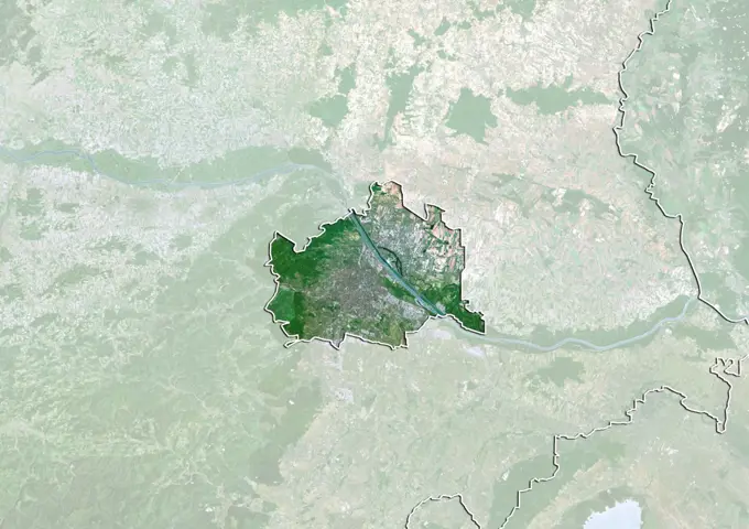
My Boards
View Pictures
  • My Boards
← Science

Satellite Views of African Regions

Collection of satellite images showcasing various African countries, highlighting landscapes, borders, and natural features captured with vibrant colors and detail.

Color satellite image of Slovakia and neighbouring countries.
278 assets in this story
1899-34928
Mount Fuji, Japan, True Colour Satellite Image. Mount Fuji, Japan, true colour satellite image. Highest point of Japan, Mount Fuji or Fuji Yama (3 776 m) is located Southwest of Tokyo. Image taken on 12 October 1999 using LANDSAT data.
6145-45259160
On June 22, 2013, the Operational Land Imager (OLI) on Landsat 8 captured this false-color image of the East Peak fire burning in southern Colorado near Trinidad. Burned areas appear dark red, while actively burning areas look orange. Dark green areas are forests; light green areas are grasslands. Lightning ignited the blaze on June 19, 2013. By June 25, it had burned nearly 13,500 acres (5,500 hectares). NASA Earth Observatory image by Jesse Allen and Robert Simmon, using Landsat data from the U.S. Geological Survey.
1899-79681
Relief map of Burundi (with border and mask). This image was compiled from data acquired by landsat 5 & 7 satellites combined with elevation data.
1899-53518009
Color satellite image of Lesotho, with borders and mask.
1899-82295
Satellite view of the State of New Mexico, United States. This image was compiled from data acquired by LANDSAT 5 & 7 satellites.
1899-35212
Cameroon, Africa, True Colour Satellite Image With Border. Satellite view of Cameroon (with border). This image was compiled from data acquired by LANDSAT 5 & 7 satellites.
1899-35282
Uganda, Africa, True Colour Satellite Image With Border. Satellite view of Uganda (with border). This image was compiled from data acquired by LANDSAT 5 & 7 satellites.
1899-79847
Satellite view of Gambia (with border and mask). This image was compiled from data acquired by LANDSAT 5 & 7 satellites.
6145-44724012
This image from NASA's EarthKAM captures almost all of Quinghai, the largest lake in China. It is located in the Quinghai Province on the Quinghai Tibetan Plateau.
1899-35413
Kyrgyzstan, Asia, True Colour Satellite Image With Mask. Satellite view of Kyrgyzstan (with mask). This image was compiled from data acquired by LANDSAT 5 & 7 satellites.
1899-35767
Lake Tanganyika, Africa, True Colour Satellite Image. True colour satellite image of Lake Tanganyika, an African Great Lake divided between four countries : Burundi, Democratic Republic of the Congo (DRC), Tanzania and Zambia. Composite image using LANDSAT 5 data.
1899-79574
Satellite view of Andorra with Bump Effect (with border). This image was compiled from data acquired by LANDSAT 5 & 7 satellites.
6145-44476575
Old Baldy Mountain peak (bottom right) and Dead Man's Basin Reservoir (top) in Montana are pictured from the International Space Station as it orbited 264 miles above North America.
1899-81766
Satellite view of Alberta, Canada. This image was compiled from data acquired by LANDSAT 5 & 7 satellites.
1899-35169
Burundi, Africa, True Colour Satellite Image With Border. Satellite view of Burundi (with border). This image was compiled from data acquired by LANDSAT 5 & 7 satellites.
1899-53517757
Color satellite image of Burkina Faso and neighbouring countries, with borders and mask.
6145-44799778
An instrument on NASA's Terra spacecraft captured a simulated natural color image of the Port-au-Prince, Haiti, area, two days after a devastating earthquake.
1899-21289869
Satellite view of Pakistan (with country boundaries). This image was compiled from data acquired by Landsat 8 satellite in 2014.
6145-44966846
Earth observation taken during a day pass by an Expedition 36 crew member on board the International Space Station (ISS).
1899-34956
El Misti Volcano , Peru, True Colour Satellite Image. El Misti volcano, Peru, true colour satellite image. El Misti (5822m) is overlooking the city of Arequipa, the second largest in Peru. Image taken on 10 May 2001 using LANDSAT data. Print size 30 x 30 cm.
6145-44934017
The Bushveld Igneous Complex (BIC) is a large layered igneous intrusion within the earth's crust, exposed at the edge of the Transvaal Basin in South Africa. Numerous mines, tailings piles, and leach ponds are shown in blue.
1899-79575
Satellite view of Andorra (with border and mask). This image was compiled from data acquired by LANDSAT 5 & 7 satellites.
1899-18416103
Color satellite image of Noor Ouarzazate Solar Complex and Ouarzazate, Morocco.  It is the largest concentrated solar power plant in the world. Image collected on July 10, 2020 by Sentinel-2 satellites.
1899-81741
Satellite view of the State of Parana, Brazil. This image was compiled from data acquired by LANDSAT 5 & 7 satellites.
1899-35148
Georgia, Asia, True Colour Satellite Image With Border And Mask. Satellite view of Georgia (with border and mask). This image was compiled from data acquired by LANDSAT 5 & 7 satellites.
1899-81801
Satellite view of the Yukon, Canada. This image was compiled from data acquired by LANDSAT 5 & 7 satellites.
1746-28998807
Lake Powell, is a reservoir on the Colorado River, straddling the border between Utah and Arizona (most of it, along with Rainbow Bridge, is in Utah). It is the second largest man-made reservoir by maximum water capacity in the United States behind Lake Mead. Satellite image, taken in 2007
1899-79987
Satellite view of Kyrgyzstan with Bump Effect (with border). This image was compiled from data acquired by LANDSAT 5 & 7 satellites.
1899-82238
Satellite view of the State of Idaho, United States. This image was compiled from data acquired by LANDSAT 5 & 7 satellites.
1899-53517755
Color satellite image of Burkina Faso and neighbouring countries.
6145-44937077
Earth Observations taken by Expedition 34 crewmember.
6145-44928802
Earth Observations taken by Expedition 34 crewmember.
1899-82118
Relief map of the district of Castelo Branco, Portugal. This image was compiled from data acquired by LANDSAT 5 & 7 satellites combined with elevation data.
6145-44779546
JPL's Advanced Spaceborne Thermal Emission and Reflection Radiometer aboard NASA's Terra satellite, shows Lhasa, the traditional seat of the Dalai Lama and capital of the Tibet Autonomous Region in China.
1899-35689
Lake Chad, Chad, In 1987, True Colour Satellite Image. True colour satellite image of Lake Chad, Chad. Image taken in 1987 using LANDSAT data.
1899-35117
Slovenia, Europe, True Colour Satellite Image With Border. Satellite view of Slovenia (with border). This image was compiled from data acquired by LANDSAT 5 & 7 satellites.
1899-35080
Liechtenstein, Europe, True Colour Satellite Image With Border And Mask. Satellite view of Liechtenstein (with border and mask). This image was compiled from data acquired by LANDSAT 5 & 7 satellites.
1899-80009
Satellite view of Lesotho with Bump Effect (with border). This image was compiled from data acquired by LANDSAT 5 & 7 satellites.
1899-21289946
Satellite view of South Sudan (with country boundaries). This image was compiled from data acquired by Landsat satellites.
1899-82328
Satellite view of the State of Tennessee, United States. This image was compiled from data acquired by LANDSAT 5 & 7 satellites.
1899-34985
Araguainha Meteor Impact Crater, Brazil, True Colour Satellite Image. True colour satellite image of Araguainha impact structure, Brazil (diameter : 40 km). Image taken on 13 May 1989 using LANDSAT data.
1899-53517701
Color satellite image of Azerbaijan and neighbouring countries, with borders.
6145-44856834
This image of the Mountain Pass rare open-pit earth mine was acquired by NASA's Terra spacecraft in southeastern California near the Nevada border.
1899-35111
Serbia, Europe, True Colour Satellite Image With Border. Satellite view of Serbia (with border). This image was compiled from data acquired by LANDSAT 5 & 7 satellites.
1899-35278
Lesotho, Africa, True Colour Satellite Image With Border. Satellite view of Lesotho (with border). This image was compiled from data acquired by LANDSAT 5 & 7 satellites.
1899-81107
Satellite view of Switzerland showing the canton of Basel Country. This image was compiled from data acquired by LANDSAT 5 & 7 satellites.
6145-45108314
iss047e091789 (May 2, 2016) --- Rocky Mountain National Park in Colorado is pictured from the International Space Station as it orbited 252 miles above.
1899-81694
Satellite view with bump effect of the State of Tyrol, Austria. This image was compiled from data acquired by LANDSAT 5 & 7 satellites.
6145-44574380
This is an image of the Bolivian capital city of La Paz that was created using three radar frequencies.
1899-21289816
Satellite view of Nepal (with country boundaries). This image was compiled from data acquired by Landsat 8 satellite in 2014.
6145-45235446
AS09-22-3341 (3-13 March 1969) --- Central Texas area as photographed from the Apollo 9 spacecraft during its Earth-orbital mission. Interstate 35 runs from Austin (right center edge of picture) to Waco (near bottom left corner). Also visible are the cities of Georgetown, Taylor, Temple and Killeen. The Colorado River runs through Austin. The Brazos River flows through Waco. Lake Travis is upstream from Austin. Lake Whitney is at bottom left corner of picture. The Belton Reservoir is near bottom center. The lake formed by the dam on the Lampasas River near Belton is also clearly visible.
6145-44765769
This image acquired by NASA's Terra spacecraft, shows the oldest material on Earth which has yet been dated by man is a zircon mineral of 4.4 billion years old from a sedimentary gneiss in the Jack Hills of the Narre Gneiss Terrane of Australia.
1899-35281
Malawi, Africa, True Colour Satellite Image With Border And Mask. Satellite view of Malawi (with border and mask). This image was compiled from data acquired by LANDSAT 5 & 7 satellites.
1899-35685
Canton And Shenzen, China, In 1990, True Colour Satellite Image. True colour satellite image of the cities of Guangzhou (Canton) and Shenzen, China. Image in landscape format, taken on 13 October 1990, using LANDSAT data.
1899-21290374
Colour satellite image of Pyongyang, North Korea. Image taken on June 6, 2014 with Landsat 8 data.
1899-82172
Satellite view of Extremadura, Spain. This image was compiled from data acquired by LANDSAT 5 & 7 satellites.
6145-44527101
This image was acquired by NASA's Terra satellite on May 2, 2000 over the North Patagonia Ice Sheet in Chile, South America.
6145-44910627
This image, acquired by NASA's Terra spacecraft, is of the abandoned town of Centralia, in eastern Pennsylvania's anthracite coal mining country.
1746-19671068
St. Anthony's, the world's oldest Christian monastery. November 13, 2009. Satellite image.
6145-45235167
Apollo 9 This infrared color photograph of the Mississippi Valley area was taken by the four synchronized cameras in the Earth Resources Survey SO65 experiment. Shown in this picture are Vicksburg and Greenville Bend. At 1 08 p.m. EST when this photo was made, the Apollo spacecraft was at an altitude of 105 nautical miles and the Sun elevation was 55 degrees above the horizon. Location of the point on the Earth's surface at which the four-camera combination was aimed was 32 degrees 41 minutes North latitude and 91 degrees 13 minutes West longitude.
1899-35334
Botswana, Africa, True Colour Satellite Image With Mask. Satellite view of Botswana (with mask). This image was compiled from data acquired by LANDSAT 5 & 7 satellites.
6145-44719590
S73-35078 (July-Sept. 1973) --- A nearly vertical view of the Phoenix, Arizona metropolitan area is seen in this Skylab 3 (second manning) Earth Resources Experiments Package S190-B (five-inch Earth terrain camera) photograph taken from the Skylab space station in Earth orbit. Also in the picture are Scottsdale, Paradise Valley, Tempe, Mesa, Komatke, Salt River Indian Reservation and part of the Gila River Indian Reservation. Features which can be delineated from the photograph include cultural patterns defined by commercial, industrial, agricultural and residential areas; transportation networks consisting of major corridors, primary, secondary and feeder streets; major urban developments in the area such as airports, Squaw Peak City Park, Turf Paradise Race Track and the State Fairgrounds. Phoenix is one of the 27 census cities of interest under study by the U.S. Geological Survey and is the center of the Arizona Regional Ecological Test Site. A large number of investigators will be
6145-44932825
Earth Observations taken by Expedition 34 crewmember.
1899-81158
Satellite view of Switzerland showing the canton of Valais. This image was compiled from data acquired by LANDSAT 5 & 7 satellites.
1899-81149
Satellite view of Switzerland showing the canton of Thurgau. This image was compiled from data acquired by LANDSAT 5 & 7 satellites.
1746-21104314
Landsat 8 scene acquired May 12, 2013 in Western Australia. The resulting image displays impressive sediment and nutrient patterns in the tropical estuary
1899-53517725
Color satellite image of Benin, with borders and mask.
1899-53518244
Color satellite image of Tajikistan, with borders and mask.
1899-34998
Gosses Bluff Meteor Impact Crater, Northern Territory, Australia, True Colour Satellite Image. True colour satellite image of Gosses Bluff impact structure, Northern Territory, Australia (diameter : 22 km). Image taken on 20 July 1990 using LANDSAT data.
1746-28998681
Retreat of Alaskas Columbia Glacier; Satellite image shows the state of glacier melting in 1995
1746-19663288
NASAs Uninhabited Aerial Vehicle Synthetic Aperture Radar (UAVSAR) captured this false-colour composite image of the city of Port-au-Prince, Haiti, and the surrounding region on Jan. 27, 2010. Port-au-Prince is visible near the centre of the image (denoted by the yellow arrow on the annotated image above). The large dark line running east-west near the city is the main airport. UAVSAR left NASAs Dryden Flight Research Centre in Edwards, Calif., Jan. 25, 2010, aboard a modified NASA Gulfstream III aircraft on a three-week campaign that will also take it to Central America.
6145-44532854
The 2002 Winter Olympics were hosted by Salt Lake City at several venues within the city, in nearby cities, and within the adjacent Wasatch Mountains. NASA's Terra satellite captured this image on May 28, 2000.
1899-34770
La Paz, Bolivia, True Colour Satellite Image. La Paz, Bolivia. True colour satellite image of La Paz, the capital city of Bolivia. Image taken on 25 May 2000 using LANDSAT 7 data.
1899-82004
Relief map of the State of Manipur, India. This image was compiled from data acquired by LANDSAT 5 & 7 satellites combined with elevation data.
6145-44502204
This topographic map acquired by NASA's Shuttle Radar Topography Mission (SRTM) from data collected on February 12, 2000 shows the western side of the volcanically active Kamchatka Peninsula, Russia.
6145-44649517
Attu, the westernmost Aleutian island, is nearly 1760 km from the Alaskan mainland and 1200 km northeast of the northernmost of the Japanese Kurile Islands. This image was acquired July 4, 2000 by NASA's Terra spacecraft.
6145-45258649
In January 2013, a new Earth-observing instrument was installed on the International Space Station (ISS). ISERV Pathfinder consists of a commercial camera, a telescope, and a pointing system, all positioned to look through the Earth-facing window of ISSs Destiny module. ISERV Pathfinder is intended as an engineering exercise, with the long-term goal of developing a system for providing imagery to developing nations as they monitor natural disasters and environmental concerns. The image above is the “first light” from the new ISERV camera system, taken at 1 44 p.m. local time on February 16, 2013. It shows the Rio San Pablo as it empties into the Golfo de Montijo in Veraguas, Panama. It is an ecological transition zone, changing from agriculture and pastures to mangrove forests, swamps, and estuary systems. The area has been designated a protected area by the National Environmental Authority (ANAM) of Panama and is listed as a “wetland of international importance” under the Ramsar Conv
6145-45261492
On Sunday, Nov. 12, 2017, a magnitude 7.3 earthquake struck along the Iran-Iraq border near Halabjah, Iraq. The earthquake was felt as far away as Kuwait, Qatar, Turkey, Lebanon and Israel. Extensive damage and numerous casualties were reported in the area near the epicenter (yellow star on image). The earthquake occurred along the boundary between the Arabian and Eurasian tectonic plates. This is an earthquake-prone area, and has experienced many deadly earthquakes in the past. In this perspective-view image, bright red areas are crops in fields, pale red on mountain ridges are shrubs and trees, dark gray areas are traces of earlier brush fires, and gray and tan colors are different rock types. The image was acquired Sept. 8, 2017, and the star marks the earthquake epicenter at 34.9 degrees north, 45.9 degrees east.
1899-81702
Satellite view with bump effect of the State of Vorarlberg, Austria. This image was compiled from data acquired by LANDSAT 5 & 7 satellites.
6145-45272062
iss062e078990 (March 4, 2020) --- The Dead Sea was pictured from the International Space Station as it orbited 263 miles above the Middle East.
6145-44529940
This image was acquired by NASA's Terra spacecraft on May 20, 2000 and shows an area along the west side of the Cascade Range in west central Oregon.
6145-45041995
Over the years of the Landsat program, the desert city of Las Vegas has gone through a massive growth spurt. The outward expansion of the city over the last quarter of a century is shown here with two false-color Landsat 5 images (August 3, 1984, and November 2, 2011). The dark purple grid of city streets and the green of irrigated vegetation grow out in every direction into the surrounding desert. These images were created using reflected light from the shortwave infrared, near-infrared, and green portions of the electromagnetic spectrum (Landsat 5 TM bands 7,4,2). ---- NASA and the U.S. Department of the Interior through the U.S. Geological Survey (USGS) jointly manage Landsat, and the USGS preserves a 40-year archive of Landsat images that is freely available over the Internet. The next Landsat satellite, now known as the Landsat Data Continuity Mission (LDCM) and later to be called Landsat 8, is scheduled for launch in 2013. In honor of Landsats 40th anniversary in July 2012, the
1746-29000193
satellite view of sao Paulo, Brazil in 1986
1899-81700
Satellite view of the State of Vienna, Austria. This image was compiled from data acquired by LANDSAT 5 & 7 satellites.
1899-80025
Satellite view of Liechtenstein (with border). This image was compiled from data acquired by LANDSAT 5 & 7 satellites.
1899-53518385
Color satellite image of the Yangtze River in 1987 and 2022, before and after the construction of the Three Gorges Dam. The dam is located in the Hubei province in central China.
1899-80101
Relief map of Nepal (with border and mask). This image was compiled from data acquired by landsat 5 & 7 satellites combined with elevation data.
6145-52930427
Chaine des Puys, France. The Chaine des Puys, about 40 kilometers long, is a chain of 48 cinder cones, 8 lava domes and 15 maars (explosion craters) in central France, west of Clermont-Ferrand. The chaine is located on the Limagne Fault, related to formation of the Alps. The most recent eruption is thought to be 4040 BCE. The image was acquired April 21, 2015, covers an area of 22.5 by 30.6 km, and is located at 45.8 degrees north, 3 degrees east. https //photojournal.jpl.nasa.gov/catalog/PIA25798
1746-19671626
The Uvs Nuur Basin in Mongolia and the Russian Federation is the northernmost of the enclosed basins of Central Asia. September 4, 2001. Satellite image.
6145-44578336
This image was acquired on June 16, 2002 by NASA's Terra satellite and shows the Hayman forest fire in the Pike National Forest, Colorado.
1899-81110
Satellite view of Switzerland showing the canton of Bern. This image was compiled from data acquired by LANDSAT 5 & 7 satellites.
1899-21989857
Color satellite image of El PasoñJuarez, a binational metropolitan area on the border between the United States and Mexico. El Paso, Texas, US is at north and Ciudad Juarez, Mexico is at south. Image collected on January 29, 2018 by Sentinel-2 satellites.
6145-45009408
NASA image acquired September 12, 2011 To view more images from this event go to a href= http //earthobservatory.nasa.gov/NaturalHazards/event.php id=52029 rel= nofollow earthobservatory.nasa.gov/NaturalHazards/event.php id=52029 /a The Bastrop County Complex Fire in southern Texas started on September 4, 2011. By September 13, 2011, the fire was 70 percent contained, but had scorched 34,068 acres (13,787 hectares). The Advanced Land Imager (ALI) on NASAs Earth Observing-1 (EO-1) satellite captured this image of the affected region on September 12, 2011. This false-color image shows a wide-area view of the fire. Vegetation is bright green, and sparsely vegetated or bare land is green-yellow. The burn scar appears in shades of red and orange. The burn scar is far from uniform; burned areas are separated by unburned expanses. As of September 13, a re-entry plan had been established for residents of the region, the Incident Information System reported. Residents were warned, however, tha
1899-34937
Villarica Volcano, Chile, True Colour Satellite Image. Villarrica volcano, Chile, true colour satellite image. Villarrica (2847m) is the most active volcano in Chile. It appears at the center of the image, covered by an ice cap. Image taken on 29 November 2001 using LANDSAT data. Print size 30 x 30 cm.
1899-82302
Relief map of the State of North Dakota, United States. This image was compiled from data acquired by LANDSAT 5 & 7 satellites combined with elevation data.
1899-35280
Malawi, Africa, True Colour Satellite Image With Border. Satellite view of Malawi (with border). This image was compiled from data acquired by LANDSAT 5 & 7 satellites.
6145-44563306
STS090-756-046 (17 April - 3 May 1998) --- A 70mm view of the Las Vegas, Nevada area, including the western-most tip of Lake Mead.  The flight track of the Space Shuttle Columbia and lack of heavy cloud cover during the 16-day Neurolab mission allowed the astronauts a number of opportunities to photograph North American cities.
6145-45253129
STS121-331-019 (4-17 July 2006) --- (North is toward the lower right corner of the image). This vertical view over glaciers in the Karakoram Mountain range of Northern India was photographed from the Space Shuttle Discovery during the STS-121 mission. The glaciers are centered at 34.8 degrees north latitude and 77.8 degrees east longitude. The small peak in the center of the photo stands 25,170 feet high.
1899-81843
Satellite view of Ningxia Hui, China. This image was compiled from data acquired by LANDSAT 5 & 7 satellites.
1746-19671642
The Uvs Nuur Basin in Mongolia and the Russian Federation is the northernmost of the enclosed basins of Central Asia. September 4, 2001. Satellite image.
PREVIOUS
of 3
NEXT
2401 S. Ervay, Suite 206
Dallas, Texas 75215
United States
Get Started
Free ResearchMy BoardsMy Cart
For Creators
How To License Your ContentContributor PortalFrame of Mind
Resources
API accessPricing
Contact
+1 866 236 0087help@viewpictures.co.uk Contact form
©2026 View Pictures. All Rights Reserved. -A
This site is protected by reCAPTCHA and Google Privacy Policy and Terms of Service apply.