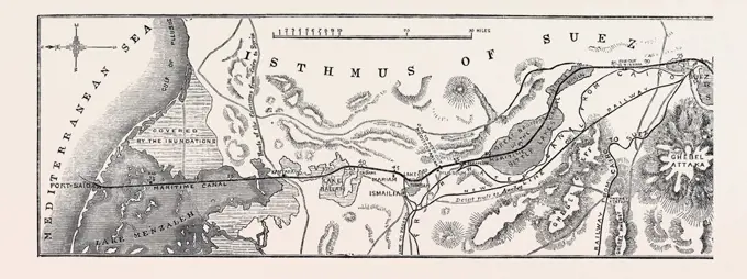
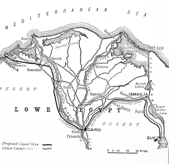
Vintage Maps of Africa and Australia

Antique maps from the 19th century depicting regions in Africa and early Australian settlements, showcasing intricate details and geographical insights.

Old map, from Massawa to Adwa, Ethiopia. East Africa. Travel in Abyssinia, 1862-1863 by Guillaume Lejean (1828 -1871) Le Tour du Monde 1867
Tycho's map of the island of Hven, Denmark. L,M,K are large fishponds. A in the centre of the island is Tycho's observatory, Uraniborg. Tycho Brahe (Tyge Ottesen Brahe - 1546-1601) Danish astronomer, astrologer and alchemist who built astronomical instruments which enabled him to make the most accurate observations of his time.Map of the Rheingau, 1844. The Rhine in Germany: '...the small district within Wiesbaden and Bacharach, or rather, properly called the Rheingau, between Walluf and Lorch, where the Rhine vends his course from east to west. The Rheingau is but a small tract of land, and strictly on the right bank of the Rhine, only occupying an area of about 25 miles. The fertility and riches of production as to the cultivation of wine is concentrated in this little spot. It is the celebrated vineyard of Germany...Charlemagne is said to have observed from his castle, Ingelheim, how early the snow commenced meltElsevier photo collection. Series: Utensils prehistoric time Map Western Europe ice age. undatedMap of Aberdeen, Scotland, as it appeared in the late 19th century.  Black and White Illustration from Our Own Country Vol III published by Cassell, Petter, Galpin & Co. in the late 19th century.Map of lighthouses in France, vintage engraved illustration. Magasin Pittoresque 1845.Map of the Siege van Gent, 1708; Plan de La Ville et Citadelle de Gand Qui Fut Assigee Par les Hauts Alliez Le 18. Decembre 1708. Map of Ghent, Bestorped from October 18 by the Allies and conquered on December 30, 1708. At the bottom of the legend 1-82 of streets and buildings in Dutch, at the top right a cartouche with the legend am of the positions of the citizen in French.Map of the arctic regions explored by Elisha Kent Kane 1853-1855. Old 19th century engraving from Le Tour du Monde 1860Plan of the Siege of Yorktown during the American Revolution, 1781Map of the department of Lot, vintage engraved illustration. Journal des Voyages, Travel Journal, (1879-80).Map of the Nile south of Gondokoro, drawn up by Baker and Speke. East Africa. Journey to Lake Albert, 1861-1864 by Samuel White Baker (1821-1893) Le Tour du Monde 1867Map of Des Landes department, vintage engraved illustration. Journal des Voyages, Travel Journal, (1879-80).''Environs de Fez; Afrique du nord', 1914. From "Grande Geographie Bong Illustree", 1914.Terra Nova. Newfoundland Island and Fishing Banks Map, Newfoundland & Labrador, Canada. Old 19th century engraved illustration, Le Tour du Monde 1863Brain: Cerebral Cortex, from van Leeuwenhoek, Epistolae physiologicae, 1719Map of department of Algiers, vintage engraved illustration. Dictionary of words and things - Larive and Fleury - 1895.Map, Tierra del Fuego, Cape Horn, Strait of Magellan, latitude, 17th century, voyage by ship, Wilhelm Schonten, Le Maire, historical illustration 1885Agricultural map of the South Region, vintage engraving. Agricultural map of the South Region, vintage engraved illustration. Magasin Pittoresque 1861. Copyright: xZoonar.com/PatrickxGuenettex 10678109Fig. 10. Southern part of the department of Var; card stuck on the terrain. vintage engraved illustration. Magasin Pittoresque 1875.Gastronomic map of France, vintage engraving. Gastronomic map of France, vintage engraved illustration. Magasin Pittoresque 1847. Copyright: xZoonar.com/PatrickxGuenettex 10673202Old map of Montenegro. Europe. Trip to Albania and Montenegro in 1858 by French explorer Guillaume Lejean. Old 19th century engraving from Le Tour du Monde 1860Experiments in Agricultural Productivity in Sologne. Photographs of Marshall Plan Programs, Exhibits, and PersonnelHistorical drawing, US-American history, 18th century, map of New York, USA, around 1760, North AmericaJerusalem old city map. Travels in Palestine, 1856-1859. Old 19th century engraving from Le Tour du Monde 1860Between 1405 and 1433, the Ming government sponsored a series of seven naval expeditions. The Yongle emperor designed them to establish a Chinese presence, impose imperial control over trade, impress foreign peoples in the Indian Ocean basin and extend the empire's tributary system. Zheng He was placed as the admiral in control of the huge fleet and armed forces that undertook these expeditions. Zheng He's first voyage consisted of a fleet of up to 317 ships holding almost 28,000 crewmen, with each ship housing up to 500 men. Zheng He's fleets visited Arabia, Brunei, East Africa, India, the Malay Archipelago and Thailand, dispensing and receiving goods along the way. Zheng He presented gifts of gold, silver, porcelain and silk; in return, China received such novelties as ostriches, zebras, camels, ivory and giraffes.Cartoon - Belt Tightening. John Collins (1917-2007)Map showing the cradle of Chinese civilization.  From the book Outline of History by H.G. Wells, published 1920.Antique map with the itinerary of Doctor Barth on his trip from Sokoto to Timbuktu in 1855. Africa. Travels and discoveries in Northern and Central Africa, 1849-1855 by Heinrich Barth (1821-1865) Le Tour du Monde 1860Course of the Rhine river before the correction in 1827, Alsace, France. Through Alsace and Lorraine, 1884 By Charles Grad (1842 - 1890) Le Tour du Monde 1886Tunis, which with Bizerta commands the Sicilian Channel.  A contour map showing the capital of Tunisia, its approaches, roads, harbour and surrounding terrain.  A strategic location during the Second World War.      Date: 1942Africa - from Ceuta to Madeira, the canaries and Cape Bojador. From Fra Mauro's map, 1457.N.N., protective wall on the southwest side of the island, Helgoland: layout plans 1: 7500, 1: 400. Lithograph on paper, 32.2 x 63.1 cm (including scan edges) N.N. : Schutzmauer an der Südwestseite der Insel, HelgolandMap of Mexico and Peru, showing the Aztec Empire and the Inca Empire.  Also shown is the black line down the right hand side of the map denoting The Treaty of Tordesillas, 1494, which divided the newlMap showing the growth of Macedonia under the rule of Philip II of Macedon, 382 -  336 BC.  From the book Outline of History by H.G. Wells, published 1920.Hydrographic map, historical illustration, Meyers Konversations-Lexikon encyclopedia, 1897Andree's Camp on White Island - After Thirty-Three Years: Dr. Horn's own map of the region they explored. Dotted lines show exact mapping of region as Horn found it and represent corrections on the existing British Admiralty map. Dr. Horn said he found the Admiralty map wrong. October 15, 1930. (Photo by The Times).Photo collection Government information service. 1600. 1600Map of Asia Minor, c.86 BC.  From Cassell's Illustrated Universal History, published 1883.Map of Bouches du Rhone, vintage engraved illustration. Dictionary of words and things - Larive and Fleury - 1895.1700S 1770S 1781 Map Of Hampton Roads Showing Placements During The Seige Of Yorktown American War Of IndependenceSiege of Breda, 1624, Claes Jansz. Visscher (II) (workshop or), 1624 print The siege of Breda by the Spanish army under Spinola, 27 August 1624 to 5 June 1625. Map of Breda and the surrounding land from Dordrecht to Turnhout. Below is a plate of Breda with the Spinola army places near Ginneken and Paolo Baglioni at Ter Heijde. Around this 5 columns of text with the legends 1-11 and A-R in Dutch.  paper etching / letterpress printing maps of separate countries or regions. maps of cities. siege, position war Breda. Ginneken. Ter HeijdeHistorical map of Palestine, Israel, Jordan, Syria, Lebanon, Middle East, Gradnetz, Dead Sea, Mediterranean Sea, Jerusalem, Bethlehem, Gaza, Tal Saron, Tal Aialon, El Gib, mountains, lakes, places, roads, AsiaSketch of the death camp on Vitön, compiled according to the information provided by Gunnar Horn and the Swedish journalist Knut Stubbendorff at Lake Interors in Tromso in 1930.Imperial Library, Deposit maps, Facsimile reduced Caspian card comic by Peter the Great, vintage engraving. Imperial Library, Deposit maps, Facsimile reduced Caspian card comic by Peter the Great, vintage engraved illustration. Magasin Pittoresque 1857. Copyright: xZoonar.com/PatrickxGuenettex 10673935Poll photo collection. Iceland. Overview card from the route that was followed by the photographer Willem van de Poll to his visit to Iceland. 1934. IcelandIllustration showing the River Thames and London's docks in 1908, viewed with Tower of London at the bottom of the image and the East of London at the top of the image. These docks consisted of 640 acres of water, with upwards of 40 miles of quayside accommodation.  1908THE ISTHMUS OF SUEZ MARITIME CANAL'Plan of Kimberley and Environs', 1900. The Siege of Kimberley took place during the Second Boer War at Kimberley, Cape Colony  From "South Africa and the Transvaal War, Vol. III", by Louis Creswicke. T. C. & E. C. Jack, Edinburgh, 1900Old map of the Coal Basin in Saon-et-Loire, France. Europe. Le Creusot et les mines de Saone-et-Loire, 1865 by Louis Laurent Simonin (1830-1886)  Le Tour du Monde 1867An engraving depicting Fowler and Baker's proposed 386km freshwater canal from Alexandria to the Suez Canal via Cairo. Dated 19th centuryA map especially prepared to illustrate the story of Captain Scott's Expedition. The shaded portion is either known or assumed to be land. Robert Falcon Scott (1868-1912) a British Royal Navy officer. Dated 20th century04/30/1906. Sketch of the Sinai Peninsula. Location of the current conflict between Türkiye and England - Approximate date.Sketch Bay Akaroa, New Zealand, vintage engraving. Sketch Bay Akaroa, New Zealand, vintage engraved illustration. Magasin Pittoresque 1843. Copyright: xZoonar.com/PatrickxGuenettex 10660663'Asia Minor - Map', 1890.   Creator: Unknown.''Le Djebel Nefousa; Le Nord-Est Africain', 1914. From "Grande Geographie Bong Illustree", 1914.Gastronomic map of France, vintage engraved illustration. Magasin Pittoresque 1847.Old map of the french coast island of Newfoundland and Labrador, Canada. French Shore of the island of Newfoundland 1886 by Lieutenant Louis Koenig (1847-1920)Mapa de las emisiones de Radio Associació de Catalunya en el radio de acción de los paises de lengua catalana. Año 1934.Map, 18th century, Island, New Caledonia, South Seas, New Hebrides, Scale, Thomas Cook, Explorer, Travel, historical illustration 1885, OceaniaWilliam Baffin (d. 1622), English navigator and explorer. Map of his voyages to the North. From the original Manuscript, drawn by Baffin.French lines, British lines, vintage engraving. French lines, British lines, vintage engraved illustration. Magasin Pittoresque 1861. Copyright: xZoonar.com/PatrickxGuenettex 10678086Black and White Illustration of Anglo Saxon Britain in the 7th century showing the Supremacy of King Penda120, 000, districts, New Garden, Vistula Mouth, Vistula, map, cartography, railway lines, hinterland, Baltic Sea, Hanseatic city, historical illustration 19th century, city map of Gdansk, Poland, city, Europe1800S 1860S 1863 Map Showing The Plan Of The Siege Of Vicksburg Mississipi By Union TroopsMap of Taprobana island. Reduced facsimile of a map in Ptolemy's Geography, in the Latin Edition of 1492. From Science and Literature in The Middle Ages by Paul Lacroix published London 1878'Plan of the Sherpur Cantonments', c1880. Artist: Unknown.Map Of Japan, Showing The Location Of Nagasaki And Hiroshima - The Two Atom Bomb Cities.Maps for slide lectures. Reproduction of a map of Egypt and Saudi Arabia. Cutout with Nile and red seaCollection of the Dutch Heidematschappij. Poplars, overview cards. undated. The Netherlands15th century map of the earth by the Italian mathematician and astronomer Paolo dal Pozzo Toscanelli historical world map, illustration from 1881Bus routes Boston Elevated Railway 1931 July 18 , Bus rapid transit, Massachusetts, Boston, Maps, Boston Mass., Maps, Boston Elevated Railway Company Norman B. Leventhal Map Center CollectionMAP OF THE OLD SPANISH & MEXICAN RANCHOS OF LOS ANGELES COUNTY.Map of the Panama Canal, vintage engraved illustration. Industrial encyclopedia E.-O. Lami - 1875.This Russian map  shows how they pictured Asia in 1737.Map of the line drawn between the basins of the Moselle and the Saone, vintage engraved illustration. Magasin Pittoresque 1844.Map showing the Allied advance eastwards across France, Belgium and Holland to the Rhine from 3 September 1945 during WWII.  From The War in Pictures, Sixth Year.Boston Elevated Railway system. Shows surface tracks and Tremont St. subway. "From map of Boston and suburbs, copyright Geo. H. Walker & Co., Walker Lith. & Pub. Co." Annotated on image: "January 1, 1898."... , Massachusetts  , Suffolk  ,county   , BostonGrand Basa settlements Cartographic. Maps. 1906. Schomburg Center for Research in Black Culture, Jean Blackwell Hutson Research and Reference Division. LiberiaArea around St. Petersburg, historic image, Meyers Konversations-Lexikon encyclopedia, 1897Map showing the partitions of Poland, from top left, Poland before 1772, after 1772, after 1793 and after 1795.  They were three partitions of the Polish-Lithuanian Commonwealth that ended the existenEDITORIAL Map showing stages of the German advances on the Eastern Front from 17 August to 6 December 1941, when the offensive was brought to a standstill.  From The War in Pictures Third YearH. Broadbent. October 12, 1936Dahomy and its environs by R. Norris Cartographic. Illustrations, Maps. 1793. Schomburg Center for Research in Black Culture, Manuscripts, Archives and Rare Books Division. Dahomey, Benin (Kingdom)City of Sarajevo, Bosnia and Herzogovina, City Map and Surroundings, Dinaric Mountains, Scale 1:80.000, City Districts, River Miljacka, Slaughterhouse, Barracks Camp, Cartography, Hatchings, Railway LineGerman threat to America and Panama: Lufthansa airlines in Latin America.  A map showing how German-controlled airlines, capable of a converging war movement against the Panama Canal, were rivalling Pan-American Airways services in South America during the Second World War.      Date: 1941300.000, ground plan, city district, railway line, cartography, historical illustration 1896, St. Petersburg and surroundings, Gulf of Finland, Baltic Sea, Russia, bay, Kronstadt Island, Krotin, Peterhof, swamp, EuropePlans for Allied Landings at Salerno 9 September 1943Jansen Hermann (1869-1945), total development plan Ankara. Surroundings of Ankara (01.03.1936): Dikmen, part of the overview plans Inv.No. 22983 to 22988 1: 10000. Tusche over a break on transparent, 46.7 x 130.2 cm (including scan edges) Jansen Hermann  (1869-1945): Gesamtbebauungsplan Ankara. Umgebung von AnkaraMap of the Nordic countries. Carte des Relations International.Map of the countries around Euphrates and Tigris from ca 1870, Babylonia, Arabia, Syria, Historic, digitally restored reproduction of an original from...Map of the Mediterranean Coast of France, vintage engraved illustration. Dictionary of Words and Things - Larive and Fleury - 1895Map of Mt. Desert Island, Maine , Tichnor Brothers Collection, postcards of the United StatesA historical document or directory from 1865 highlighting Pierrepont Center Village, East Pierrepont Village, and the Pierrepont Centre Business Directory. This publication is linked to the original Township of De Witt and part of Clare Township, issued in Philadelphia, Saint Lawrence County, New York. The document includes the geographic and administrative context of the area as it pertains to real property in the state of New YorkOnline surveys of Ocean between Newfoundland and Ireland, vintage engraved illustration. Magasin Pittoresque 1857.Photo collection Government information service. The Netherlands in the beginning of the Middle Ages. undatedGrundriss von der stadt Boston und ihren gegenden , Boston Mass., Maps, Early works to 1800 Norman B. Leventhal Map Center CollectionRoyal Tour - The Homeward JourneyThe last stage of the Royal tour, bringing the Queen and the Duke of Edinburgh home to Britain, is illustrated in this specially prepared map. The Queen and the Duke sail from Tobruk on May 1 in the new Royal yacht Britannia. With them will be Prince Charles and Princess Anne, who sailed out i the ship to meet their parents.The passage through the Mediterranean will include stops at Malta and Gilbraltar.The voyage ends when the Queen and her husband and children reach London on May 15. April 28, 1954. (Photo by Reuterphoto).Black and white photograph of World War II (1939-1945) showing a map of battlefields in Cherbourg and Caen between 27 June and 9 July 1944.The Greater East Asia Co-Prosperity Sphere (Dai-to-a Kyoeiken) was a concept created and promulgated during the Showa era by the government and military of the Empire of Japan. It represented the desire to create a self-sufficient bloc of Asian nations led by the Japanese and free of Western powers. The Japanese Prime Minister Fumimaro Konoe planned the Sphere in 1940 in an attempt to create a Great East Asia, comprising Japan, Manchukuo, China, and parts of Southeast Asia, that would, according to imperial propaganda, establish a new international order seeking co prosperity’ for Asian countries which would share prosperity and peace, free from Western colonialism and domination. In historical fact, the Greater East Asia Co-Prosperity Sphere is remembered largely as a front for the Japanese control of occupied countries during World War II, in which puppet governments manipulated local populations and economies for the benefit of Imperial Japan.Creusot and Montchanin coalfields, France. Europe. Le Creusot et les mines de Saone-et-Loire, 1865 by Louis Laurent Simonin (1830-1886)  Le Tour du Monde 1867'La bataille de la Somme; La prise de Combles.', 1916. From "Collection de la Guerre IV. L'Illustration Tome CXLVII. La Guerre Juillet, Aout, Septembre, Octobre, Novembre, Decembre 1916".