My Boards
View Pictures
  • My Boards
← Documents & Records

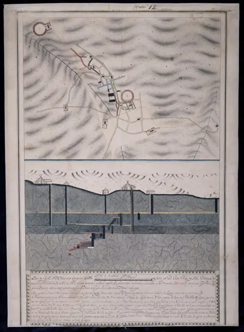
18th Century Siege Maps

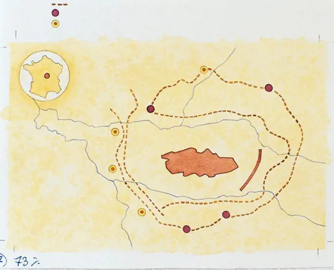
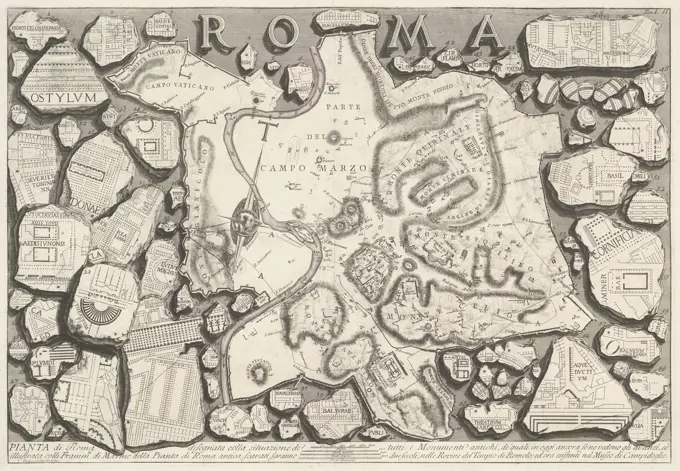
Detailed maps depicting siege plans from the early 18th century during the War of Spanish Succession, showcasing military strategies and city layouts.

Chart of the gulf and river of St. Lawrence , Nautical charts, Saint Lawrence River, Early works to 1800, Nautical charts, Saint Lawrence, Gulf of, Early works to 1800, Saint Lawrence River, Maps, Early works to 1800, Saint Lawrence, Gulf of, Maps, Early works to 1800 Norman B. Leventhal Map Center Collection
262 assets in this story
6145-43861576
West Indies, south east coast of Jamaica, Morant Bay and the coast from Fisherman Bay to Belvidere Point : from a British survey in 1874 , Nautical charts, Jamaica, Morant Bay, Morant Bay Jamaica, Maps Norman B. Leventhal Map Center Collection
6145-59310613
Profile of the northeast coast of Java, Anonymous, 1744 drawing Equipped with the annotation "in the ship Adrichem on the Reijze after Macassar on 12th March 1744". Further annotations provide details about depicted landmarks.  paper. ink pen / brush island (in tropical and sub-tropical regions) Java
6145-59512672
Fragment of card network of Northern Hemisphere, Anonymous, in Or Before 1596 print Fragment of a card network, numbered 30, 40, 50, 70, 80 and 90. A network of lines used for location. A semi -circular network of lines; The system of earthly meridians and parallels in equatorial stereographic projection. The card network was probably used in combination with the Length Guide of Plancius. Northern Netherlands paper engraving maps, atlases
6145-54573468
Wampum. Rosenthal, Max (1833-1918). 1853 - 1885. Prints. The Miriam and Ira D. Wallach Division of Art, Prints and Photographs: Print Collection. Albany Congress (1754 : Albany, N.Y.), Wampum
6145-59310611
Two profiles of the northeast coast of Java, Anonymous, 1744 drawing In addition to the profiles, a handwritten legend has been recorded, with references to numbers at the profiles. Also equipped with the annotation "In 't Schip Adrichem on the Reijze after Macassar den 12th March 1744".  paper. ink pen / brush island (in tropical and sub-tropical regions) Java
6145-46739144
Large copper mountain chronology. From Carl Sahlin's mountain historical collection.
6145-55957905
The State of New York: from new and original surveys Cartographic. Maps. 1861. Lionel Pincus and Princess Firyal Map Division. Geology , New York (State), Meteorology , New York (State), New York (State), New York (State) , Administrative and political divisions, New York (N.Y.)
6145-59601187
Map of Easter Island, Anonymous, c. 1795 print   paper etching maps, atlases Easter Island
6145-30306676
Basic plan and length profile of the canal from the Danube to Maine nd section around
6145-59512670
Fragment of card network of Northern Hemisphere, Anonymous, in Or Before 1596 print Fragment of a card network, numbered 10. A network of lines used for location. A semi -circular network of lines; The system of earthly meridians and parallels in equatorial stereographic projection. The card network was probably used in combination with the Length Guide of Plancius. Northern Netherlands paper engraving maps, atlases
6145-48717944
Canadian Rockies showing main line of Canadian Pacific Ry. with branch lines & steamship connections , Canadian Pacific Railway Company, Aerial views, Canadian Pacific Railway Company, Maps, Railroads, British Columbia, Maps, Railroads, Alberta, Maps, Alberta, Aerial views, British Columbia, Aerial views, Canadian Rockies B.C. and Alta., Aerial views, Canadian Rockies B.C. and Alta., Maps Norman B. Leventhal Map Center Collection
4220-20429243
A step-by-step diagram demonstrating the new transatlantic telephone system between Britain and the United States in 1927.    The process involved the British caller asking for 'American Service, please' after which the call would be put through the English transmitting station at Rugby.  Here it is transferred by wireless and flung out to space.  Crossing the Atlantic it reaches the receiving station at Houlton, Maine, USA and then by cable to New York.  An operator would observe the needle of
6145-51397749
Off-street parking inventory within Boston proper , Boston Mass., Maps, Parking, Massachusetts, Boston, Maps
1788-17607
City plan of Gallic Alesia and lines of the siege by Julius Caesar in 52 BC that ended Gallic resistance to Caesar, drawing
6145-43524019
Bound Print (France)
6145-51484460
Caption: Map of France showing the sections and front line in October 1918, prepared under the direction of Brig. Gen. Hugh Drum, Chief of Staff, 1st Army U.S.A. Vincennes, Seine, France. The map provides an overview of the different sections and their positions during the war.
6145-55959023
Vingthuitième partie de la carte du Nil, depuis Guad ell Arab, jusqu'à Kudjuhed. Norden, Frederik Ludvig, 1708-1742. Cartographic. Illustrations, Prints. 1780. General Research Division. Egypt , Description and travel, Egypt , Antiquities, Archaeological sites , Egypt, Nile River
6145-51391804
Carta particolare della America è parte maestrale dal C. di Cedros , Nautical charts, Early works to 1800, Coasts, California, Maps, Early works to 1800, Baja California Mexico : Peninsula, Maps, Early works to 1800, Pacific Coast Calif., Maps, Early works to 1800, Pacific Coast Mexico, Maps, Early works to 1800 Norman B. Leventhal Map Center Collection
6145-55917680
Carta particolare della America e parte maestrale dal C. di Cedros. Map of the Pacific Coast from Baha California to California, showing coastal towns, harbors, prevailing winds, ocean currents, and magnetic deviations of the compass. Depth shown by soundings. Prime meridian: Pico. "D'America carta XXXII." In Dudley's Dell'arcano del mare, 1646-1647. Cataloging, conservation, and digitization made possible in part by The National Endowment for the Humanities: Exploring the human endeavor.... , California Mexico  , Baja California  ,area
6145-55956956
Relief map of New York and vicinity Reproduction of relief map published by U. S. Geological Survey. 1917. Cartographic. Maps. Lionel Pincus and Princess Firyal Map Division
6145-30289468
Vienna Austria - Vienna in Austria , Panorama of Vienna with a dedication address to Karl VI, A demolition of city history and a situation legend with  digits in Latin and German, Matthias Anton Weiß, Drawer, Christian Engelbrecht -, Copper Engraver, Johann Andreas d, Pfeffel -, Copper Engraver
6145-54533967
Southern and small stone pyramids of Dashhoor: view, plans, sections, and hieroglyphics.. Perring, John Shae, 1813-1869. Perring, John Shae, 1813-1869. Prints, Illustrations. 1842. General Research Division. Pyramids , Egypt, Pyramids of Giza (Egypt)
6145-48480708
N.N., Garden of the Daisenin Temple, Kyoto (without Dat.): Planting plan 1:50. Pressure on paper, 31.1 x 39.8 cm (including scan edges) N.N. : Garten des Daisenin-Tempels, Kyoto
4443-73225627
Rome, Piranesi, Giovanni Battista, Le Antichità Romane, Archaeological finds in and around Rome, Pianta di Roma, Plan of Rome, verso - stamped, Plan of Rome. All around on various marble fragments more elaborate plans of buildings. Title and scale divisions in the bottom margin. Numbered at top right: Tol. I. II, print, prent, prints, prenten, height 462 mm, width 676 mm, Italian, 1720-10-04 - 1778-11-09, print maker, printmaker, 1756 - 1757, paper, papier, etching, etchings, Work conception, after own design by
6145-54267701
J. Schedler's relief map of Boston and environs. Raised relief map. Depths shown by soundings. Longitude from Boston State House.. Three-dimensional relief maps are visual aids that assist schoolchildren in understanding physical terrain. The first relief maps were created in China, and appeared in Europe in the late 18th century. This map of Boston and vicinity demonstrates the hilly character of the suburbs and harbor islands.. Relief map of Boston and environs. Relief map of Boston and environs, Massachusetts  , Boston Harbor Massachusetts  , Suffolk  ,county   , Boston
4443-21170199
THE THAMES, FROM RATCLIFFE TO WOOLWICH IN 1588, UK
1848-50773357
A section from the cartographic representation of the Peutinger's Table (Tabula Peutingeriana), UNESCO World Document Heritage, historical world map, illustration from 1881
6145-52375357
Veduta delle Piramidi di Gjizéh, del Cairo, Boulac e forstath.. Denon, Vivant, 1747-1825. Denon, Vivant (1747-1825). Prints, Illustrations. 1808. General Research Division. Egypt , Description and travel, Pyramids of Giza (Egypt), Pyramids , Egypt , Jîzah
6145-48673091
Maps, Spot Pond and surrounding land, Stoneham, Mass., Dec. 1900 , waterworks, reservoirs water distribution structures, engineering maps
6145-29668398
Photo collection Government information service. Aerial recording. Rotterdam after destruction by German bombing south is above. May 1940. Rotterdam, South Holland
6145-48483146
N.N., fishing ports in Holland. (From: Atlas to the magazine for Building, ed. V.F. Endell, Jg. 37, 1887) (1887-1887): Site plans. Lithograph on paper, 29.5 x 45.6 cm (including scan edges) N.N. : Fischerhäfen in Holland. (Aus: Atlas zur Zeitschrift für Bauwesen, hrsg. v. F. Endell, Jg. 37, 1887)
4409-20924673
PLANO Y PERFIL DE LA MINA DE LA CONCEPCION - 1822. Author: ROJO Y SALAS JUAN. Location: MINAS DE ALMADEN-ARRAYANES. CIUDAD REAL. SPAIN.
6145-48717840
J. Schedler's relief map of Boston and environs , Boston Mass., Maps, Massachusetts, Maps, Boston Harbor Mass., Maps, Boston Harbor Mass., Relief models, Boston Mass., Relief models, Massachusetts, Relief models Norman B. Leventhal Map Center Collection
6145-59570521
Siege of Brussels (left half), 1697, 1697 print Left half of a large map of Brussels and the surrounding area during the siege of the city by the Allies under King William III from August 1697. Left a curtain stopped by angels with lists of the officers and regiments, below a cartouche with allegorical figures and the assignment in French. At the bottom of part of the legend 1-48 in French.  paper etching siege, position war. maps of cities Brussels
6145-52375238
Vues de Malte.. Denon, Vivant, 1747-1825. Denon, Vivant, 1747-1825. Prints, Illustrations. 1829. Rare Book Division. Egypt , Description and travel, Malta
6145-55959742
Travnik und Bugojno. Cartographic. Maps, Topographic maps. 1910. Lionel Pincus and Princess Firyal Map Division
6145-29175361
Contemporary Kimono Patterns 1677 Hishikawa Moronobu 川師宣 Japanese. Contemporary Kimono Patterns. Hishikawa Moronobu 川師宣 (Japanese, 1630/31?-1694). Japan. 1677. First volume from a set of woodblock-printed books; ink on paper. Edo period (1615-1868). Illustrated Books
6145-59255609
Cartoon about the role of Holland within Europe, 1869, 1869 print Cartoon with a map of Holland with the North Sea Canal and the rail connections of Amsterdam and Rotterdam with Europe. Plaat appeared at the Weekblad De Nederlandsche Spectator, no. 27, 1869. print maker: Netherlandsprinter: Netherlandspublisher: Arnhempublisher: The Hague paper   North Holland. South-Holland. North Sea Canal. Amsterdam. Rotterdam
6145-46543783
. .
6145-46437461
Loose fragments of an image of Paris judgment. Ten fragments from Mercury hidden in a tree.
4220-20432547
From Thermopylae to Athens: the last valiant British retreat.  A relief map looking southwards, showing the 'last stages of a glorious rearguard action' during the Battle of Greece, Second World War.      Date: 21-26 April 1941
6145-51932468
Sweden, Blekinge, Blekinge, Karlskrona, Karlskrona, external marina (depicted, town).Sweden, Blekinge, Blekinge, Karlskrona, Karlskrona, External War Gogs (depicted, City)
6145-44034985
Festivement building, EsarTpicpical descriptive, Sitting Misses
4443-75469170
Situationsplan des Pyramiden-Feldes von Meidum and Situationsplan des Pyramiden-Feldes bei Illahun., 1849 - 1856, Berlin, Publisher, Nicolaische Buchhandlung. Subjects include Egypt, Antiquities, Pyramids, and Pyramid of Sesostris II., Two images on one page
4220-20432499
The situation of Britain face to face with a German north-west Europe: factors governing an invasion during the Second World War.  A map giving the distances from the ports held by the Germans to points in the British Isles, and a schematic illustration of the vast quantity of shipping needed for transporting even a small invading force.      Date: 1940
6145-48513998
Fragment, Cooper Union Museum Lace Study Card; linen
6145-45378516
Colorful embroidery project for a napkin W Niechska, Anna
6145-55927953
Cartographic, Maps. 1884 - 1936. Lionel Pincus and Princess Firyal Map Division. Fire insurance , New York (State), Real property , New York (State), Cities & towns , New York (State) Key
4409-17485136
Band. Date/Period: 17th century. Band. Medium: linen. Technique: plain weave with cut work, withdrawn element work, and embroidery. Author: UNKNOWN.
6145-46360047
Map of Rome; Pianta di Roma (...); Archaeological finds in and around Rome; Le Antichità Romane. Map of Rome. Allowed floor plans of buildings from buildings around on different marble uncheckings. Title and scale divisions in undermarge. Numbered at the top right: toll. I. II
6145-30209963
Detailed map of Rohan, 1875 Leon SYMONNEYE (1803-1879). Detailed plan of the Rohan Court. Feather, pencil, lavis pink, 1875. Paris, Carnavalet museum.
6145-52972761
Map of the surroundings, published by Gustaf Ljungren
6145-43809560
Maps, map of the route of the Weston Aqueduct, Mass., Oct. 1901 , waterworks, aqueducts, engineering maps
6145-48719256
The public libraries of Massachusetts , Public libraries, Massachusetts, Maps, Facsimiles, Massachusetts, Maps, Facsimiles, Boston Public Library Norman B. Leventhal Map Center Collection
6145-29604593
Collection Dutch Heidematschappij. Presentation month month food. undated
6145-29662139
Photo collection Service for army contacts Indonesia. DLC Visit to Sidikalang. Republican poster. Text ¨koem Boeroah than Kaem-Tani Dari Seola Bangsa than Agama. Bersa helper !!!. Signs 'Oleh Marhaen'. January 14, 1949. Indonesia, Dutch East Indies
6145-29095838
1934 Showa 9 Panoramaic Map of Japan, Korea, Taiwan and Manchuria
6145-55135635
Ox bows. Alaska Task Force Photographs
6145-48447506
Jansen Hermann (1869-1945), Planning for Plowdiw (January 22, 1944): General development plan, part K (4b) 1: 5000 (from Inv.No. 22358). Light break on paper, 52.2 x 45.1 cm (including scan edges) Jansen Hermann  (1869-1945): Planung für Plowdiw
6145-43793256
Wachusett Reservoir, Wachusett Dam, upper temporary dam (plan), Clinton, Mass., Feb. 24, 1902 , waterworks, dams, diagrams
6176-66906846
Map of the Chitral Campaign
1746-19700354
The Malabar Coast. From Fra Mauro's map.
PREVIOUS
of 3
NEXT
2401 S. Ervay, Suite 206
Dallas, Texas 75215
United States
Get Started
Free ResearchMy BoardsMy Cart
For Creators
How To License Your ContentContributor PortalFrame of Mind
Resources
API accessPricing
Contact
+1 866 236 0087help@viewpictures.co.uk Contact form
©2026 View Pictures. All Rights Reserved. -A
This site is protected by reCAPTCHA and Google Privacy Policy and Terms of Service apply.