My Boards
View Pictures
  • My Boards

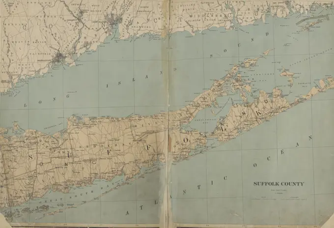
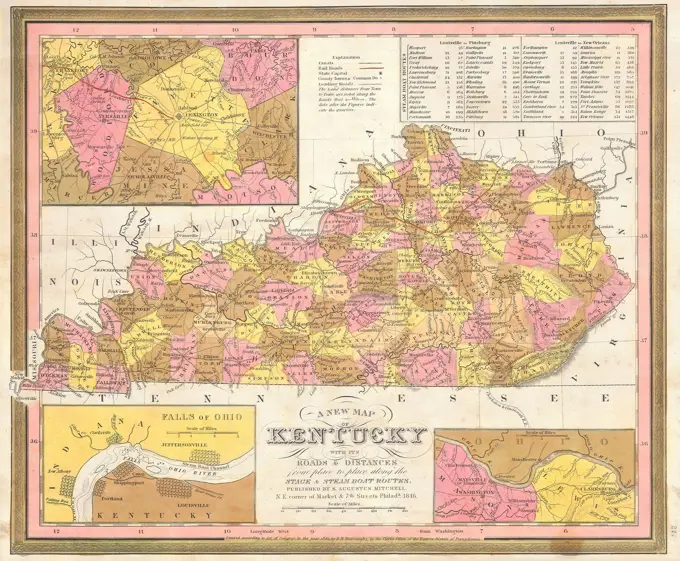
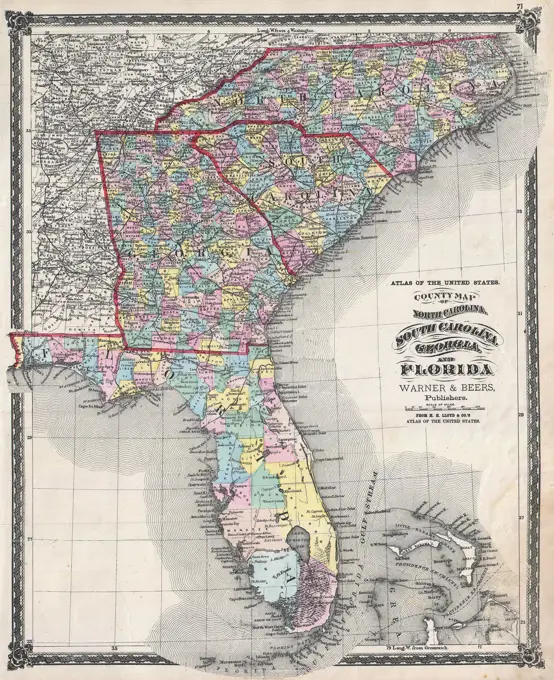
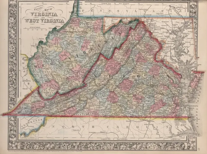
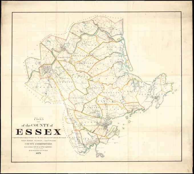
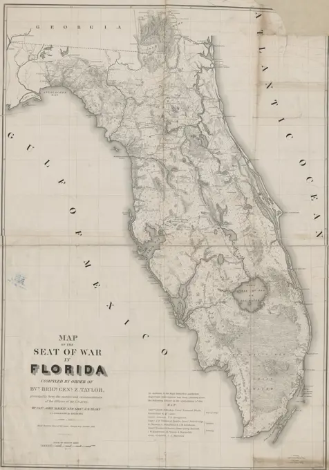
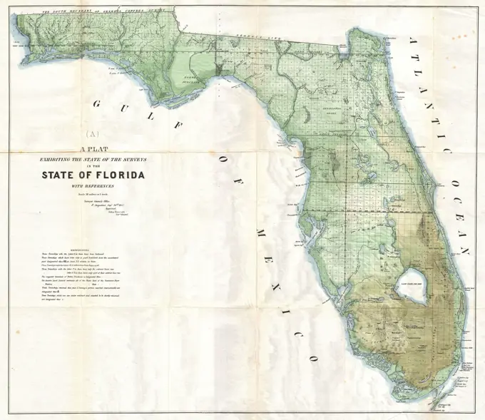
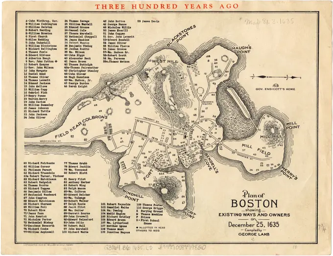
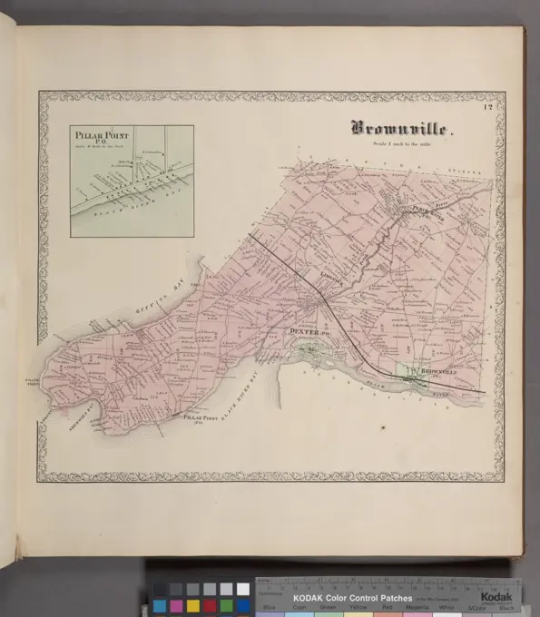
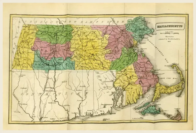
19th Century U.S. Maps

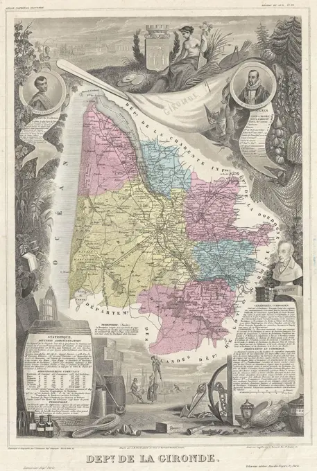
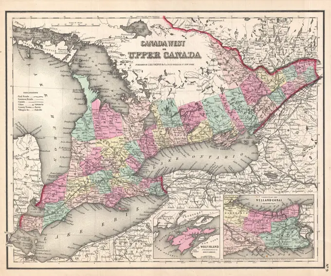
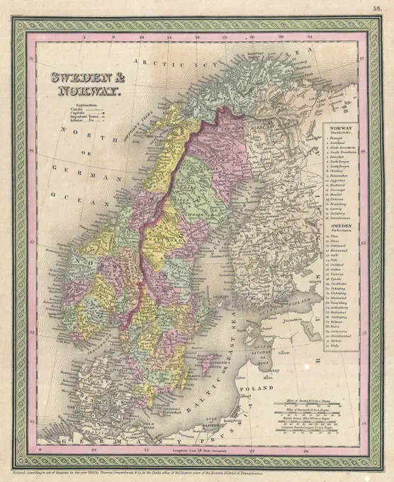
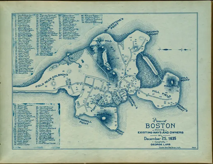
Collection of antique maps showing various states in the U.S., detailing railroads, political boundaries, and geographical features from the late 1800s.

Map, Historical Collections  relating to the history and antiquities of every town in Massachusetts, 19th century engraving, US, America
Map, Historical Collections relating to the history and antiquities of every town in Massachusetts, 19th century engraving, US, America
258 assets in this story
6145-48717981
E. & G.W. Blunt's map of Charleston and vicinity , Charleston S.C., Maps Norman B. Leventhal Map Center Collection
6145-51396231
Map of Cambria Co., Penna , Cambria County Pa., Maps Norman B. Leventhal Map Center Collection
6145-55957599
Map of The State of New Jersey Cartographic. Atlases, Maps. 1873. Lionel Pincus and Princess Firyal Map Division. Monmouth Couty (N.J.) , Description and travel, Real property , New Jersey , Monmouth County
4443-75475391
New York State, Double Page Plate No. 8 Map of Suffolk County, 1895, published by Joseph R. Bien in New York., 1895
6145-50568573
Map of the town of Lenox Berkshire Co. Massachusetts , Lenox Mass., Maps Norman B. Leventhal Map Center Collection
6145-29096684
1846 Burroughs - Mitchell Map of Kentucky
6145-55916878
Rand McNally official 1920 auto trails map : District number 6 : New England, eastern New York. Does not cover northern tip of New Hampshire and northern Maine. Shows roads, mileage between points, population of cities and towns, and selected hotels and garages. Map attached to inside back cover of booklet. Inset: Map of south eastern Maine. Booklet includes motor vehicle laws, "Hotel and garage register", 32 maps of urban areas, index map to series of Official auto trail maps, and advertisements... Rand-McNally official auto trails map : District no. 6 : New England Official 1920 auto trails map : District number 6 : New England, Eastern New York Official auto trails map : District number 6 : New England, Eastern New York. Rand-McNally official auto trails map : District no. 6 : New England Official 1920 auto trails map : District number 6 : New England, Eastern New York Official auto trails map : District number 6 : New England, Eastern New York, New England  ,area  New York
6145-51395135
Map of the town of Lenox Berkshire Co. Massachusetts , Lenox Mass., Maps Norman B. Leventhal Map Center Collection
6176-66906400
Map of the Shore Line Rail Road route between New York and Boston, showing its rail road and steamboat connection with New York, New Haven, New London, Stonington, Providence, Newport, and Boston.1860
6145-50571514
War maps and diagrams , United States, History, Civil War, 1861-1865, Maps Norman B. Leventhal Map Center Collection
6145-29095635
1874 Beers Map of Florida, Georgia, North Carolina and South Carolina
4443-75462584
County map of Virginia and West Virginia, 1863., 1863., Philadelphia. Publisher, S. A. Mitchell, Jr
6176-61904116
1857, Colton Map of Ontario, Canada
6145-55181311
Plan of the State of New York. Cartographic. Atlases, Maps. 1868. Lionel Pincus and Princess Firyal Map Division. Otsego County (N.Y.), Real property , New York (State) , Otsego County
6145-29095116
1861 Levasseur Map of the Department de la Gironde (Bordeaux Wine Region)
6145-55955981
Map of Long Island showing the Long Island Railroad system and Montauk Steamboat Company's lines Cartographic. Maps. 1908. Lionel Pincus and Princess Firyal Map Division. Long Island Railroad Company, Railroads , New York (State) , Long Island (N.Y.), Long Island (N.Y.)
6145-58841813
Map of land between Maas, Waal and Rijn, Anonymous, 1735 Map of the country located between the Maas, Waal and Rijn rivers. At the bottom of three naked fighting children at the cartouche with a title. Part of an atlas with 223 maps of countries and cities and war scenes in Europe in the period ca. 1690-1735. print maker: Northern Netherlandspublisher: Amsterdampublisher: Amsterdam paper etching / engraving / lacquering  Mesh. Waal. Rhine Map of the country located between the Maas, Waal and Rijn rivers. At the bottom of three naked fighting children at the cartouche with a title. Part of an atlas with 223 maps of countries and cities and war scenes in Europe in the period ca. 1690-1735. print maker: Northern Netherlandspublisher: Amsterdampublisher: Amsterdam paper etching / engraving / lacquering  Mesh. Waal. Rhine
6145-29094996
1857 Colton Map of Ontario, Canada
6145-51395041
Map of the province of Nova Scotia to illustrate report by E.R. Faribault, B.A. Sc. on the 'Gold fields of Nova Scotia' , Geology, Nova Scotia, Maps, Granite, Nova Scotia, Maps, Mines and mineral resources, Nova Scotia, Maps, Gold mines and mining, Nova Scotia, Maps, Nova Scotia, Maps Norman B. Leventhal Map Center Collection
6145-51397002
Scarborough's new county and post office map of Virginia, Maryland, Delaware, and District of Columbia : with complete index giving population and location , Virginia, Maps, Maryland, Maps, Delaware, Maps, Washington D.C., Maps Norman B. Leventhal Map Center Collection
6145-54268500
Plan of Boston showing existing ways and owners on December 25, 1638. From A series of plans of Boston, showing existing ways and owners of property from December 25, 1630 to December 25, 1645 inclusive. Atlas published 1903.... , Massachusetts  , Suffolk  ,county   , Boston
6145-51386809
Public outdoor recreation master plan , Recreation areas, Massachusetts, Maps, Massachusetts, Maps
6145-51396492
Industrial map of New England , Industries, New England, Maps, New England, Maps Norman B. Leventhal Map Center Collection
6145-55914001
Industrial map of New England. Inset: Boston & vicinity. Manufacturing activity shown pictorially. On verso: Alphabetical list of industrial towns in New England with their principal industries. Date of publication estimated from date of acquisition.... , New England  ,area
6145-50568009
Florida gebiet , Florida, Maps Norman B. Leventhal Map Center Collection
6145-29096780
1850 Mitchell Map of Scandinavia, Norway, Sweden, Denmark, Finland
6145-51396615
A survey of the empire group : with a complete distance table, a compendious index of cities and post offices, with populations and much statistical data , Middle Atlantic States, Maps, New York State, Maps, Pennsylvania, Maps, New Jersey, Maps Norman B. Leventhal Map Center Collection
6145-50511156
Plan of Boston showing existing ways and owners on December 25, 1635 , Homeowners, Massachusetts, Boston, Maps, Landowners, Massachusetts, Boston, Maps, Boston Mass., History, Colonial period, ca. 1600-1775, Maps Norman B. Leventhal Map Center Collection
6145-51389032
Wakefield, Massachusetts : diagram showing the first ten miles of the Boston & Maine Railroad , Boston and Maine Railroad, Maps, Railroads, Massachusetts, Boston, Maps, Railroads, Massachusetts, Wakefield, Maps, Wakefield Mass., Maps, Boston Mass., Maps Norman B. Leventhal Map Center Collection
6145-50511164
Plan of Boston showing existing ways and owners on December 25, 1637 , Boston Mass., Maps, Landowners, Massachusetts, Boston, Maps Norman B. Leventhal Map Center Collection
6145-55957689
Outline Plan of Orange County New York Cartographic. Atlases, Maps. 1875. Lionel Pincus and Princess Firyal Map Division. Orange County (N.Y.), Real property , New York (State) , Orange County, Orange County (N.Y.) , History, Business enterprises , New York (State) , Orange County
6145-54268505
Plan of Boston showing existing ways and owners on December 25, 1642. From A series of plans of Boston, showing existing ways and owners of property from December 25, 1630 to December 25, 1645 inclusive. Atlas published 1903.... , Massachusetts  , Suffolk  ,county   , Boston
6145-50568554
Somerset Co., Penn'a , Landowners, Pennsylvania, Somerset County, Maps, Somerset County Pa., Maps Norman B. Leventhal Map Center Collection
6145-52359189
General map of the Government Railways in Japan Japan. Tetsudin. Cartographic. Maps. 1910 - 1919. General Research Division. Japan
6145-51396765
The National Publishing Company's railroad, post office, township and county map of Massachusetts, Rhode Island and Connecticut : with distances in figures compiled from the latest government surveys and original sources , Railroads, Connecticut, Maps, Railroads, Massachusetts, Maps, Railroads, Rhode Island, Maps, New England, Maps, Rhode Island, Maps, Connecticut, Maps, Massachusetts, Maps Norman B. Leventhal Map Center Collection
6145-55957394
Niagara, Orleans, Genesee, Monroe, and Wayne counties" Cartographic. Atlases, Maps. 1871. Lionel Pincus and Princess Firyal Map Division. New York (State)
6145-50511161
Plan of Boston showing existing ways and owners on December 25, 1640 , Boston Mass., Maps, Landowners, Massachusetts, Boston, Maps Norman B. Leventhal Map Center Collection
6145-54268502
Plan of Boston showing existing ways and owners on December 25, 1640. From A series of plans of Boston, showing existing ways and owners of property from December 25, 1630 to December 25, 1645 inclusive. Atlas published 1903.... , Massachusetts  , Suffolk  ,county   , Boston
6145-52359808
Schoharie County Cartographic. Atlases, Maps. 1866. Lionel Pincus and Princess Firyal Map Division. Schoharie County (N.Y.), Real property , New York (State) , Schoharie County, Business enterprises , New York (State) , Schoharie County
6145-55914948
Map of the seat of war in Florida. Relief shown by hachures. Shows forts, battle locations, and U.S. lines of attack.... , Florida
6145-51396389
Plan of the county of Essex : compiled from the original furnished by the state and corrected under the direction of James Kimball, J.B. Sweet, Chas. P. Preston, county commissioners : in accordance with the act of the legislature, (see chap 17 sec 8 gen'l statutes) , Essex County Mass., Maps Norman B. Leventhal Map Center Collection
6145-48717604
Plan of Boston showing existing ways and owners on December 25, 1630 , Boston Mass., Maps, Landowners, Massachusetts, Boston, Maps Norman B. Leventhal Map Center Collection
6145-55181319
Springfield Business Directory. ; Town of Springfield, Otsego Co. N.Y. Township Cartographic. Atlases, Maps. 1868. Lionel Pincus and Princess Firyal Map Division. Otsego County (N.Y.), Real property , New York (State) , Otsego County
6145-55917403
A topographical map of the island of Barbados : based upon Mayo's original survey in 1721 and corrected to the year 1846. Relief shown by hachures. Includes profile: Section N.N.W. and S.S.E. through Mount Hillary on a true scale. Boston Public Library copy imperfect: assembled, dissected and mounted on cloth.... , Barbados
6145-55917193
State of Florida. Relief shown by hachures. "J.A. Williamson, Commissioner." Prime meridians: Washington and Greenwich.... , Florida
6145-54268241
A New Yorker's idea of the United States of America. Includes ill. and description.... , United States
4443-75469733
Map titled 'Map of the seat of war in Florida,' compiled in 1839 by order of Bvt. Brigr. Genl. Z. Taylor, based primarily on surveys and reconnaissances conducted by officers of the U.S. Army. The map illustrates the regions involved in the Seminole War (1835-1842) in Florida, particularly around Tampa Bay. It measures 103 x 72 cm on a sheet of 113 x 78 cm. The publisher is identified as the Head Quarters, Army of the South
6176-66094288
Vintage Tourist Map.  Vacuum road guide to New South Wales, Australia  / Clive Barrass,.  1939
6145-29094721
1853 Land Office Plat Map of Florida
6145-54549472
Three Mile Bay Village; Three Mile Bay Business Directory. ; Lyme Township; Wilcoxville Business Directory. ; Wilcoxville Village Cartographic. Atlases, Maps. 1864. Lionel Pincus and Princess Firyal Map Division. Jefferson County (N.Y.), Real property , New York (State)
6145-54549464
Champion. Township Cartographic. Atlases, Maps. 1864. Lionel Pincus and Princess Firyal Map Division. Jefferson County (N.Y.), Real property , New York (State)
6145-55916199
Plan of Boston showing existing ways and owners on December 25, 1635. Oriented with north to the right. Relief shown by hachures. Includes index to names of landowners.... , Massachusetts  , Suffolk  ,county   , Boston
6145-50584701
Cape Cod Auto Map , Maps, Tichnor Brothers Collection, postcards of the United States
6145-52359736
Outline Map of Fulton Co. New York Cartographic. Atlases, Maps. 1868. Lionel Pincus and Princess Firyal Map Division. Real property , New York (State) , Montgomery County, Real property , New York (State) , Fulton County, Montgomery County (N.Y.), Fulton County (N.Y.)
6145-55181370
Raritan Township Cartographic. Atlases, Maps. 1873. Lionel Pincus and Princess Firyal Map Division. Monmouth Couty (N.J.) , Description and travel, Real property , New Jersey , Monmouth County
6145-54549445
Pillar Point P.O. Village; Brownville. Township Cartographic. Atlases, Maps. 1864. Lionel Pincus and Princess Firyal Map Division. Jefferson County (N.Y.), Real property , New York (State)
6145-54549478
Rutland Township Cartographic. Atlases, Maps. 1864. Lionel Pincus and Princess Firyal Map Division. Jefferson County (N.Y.), Real property , New York (State)
6145-55957581
Town of Morris,Otsego Co. N.Y. Township; Morris Business Directory. Cartographic. Atlases, Maps. 1868. Lionel Pincus and Princess Firyal Map Division. Otsego County (N.Y.), Real property , New York (State) , Otsego County
PREVIOUS
of 3
NEXT
2401 S. Ervay, Suite 206
Dallas, Texas 75215
United States
Get Started
Free ResearchMy BoardsMy Cart
For Creators
How To License Your ContentContributor PortalFrame of Mind
Resources
API accessPricing
Contact
+1 866 236 0087help@viewpictures.co.uk Contact form
©2026 View Pictures. All Rights Reserved. -A
This site is protected by reCAPTCHA and Google Privacy Policy and Terms of Service apply.