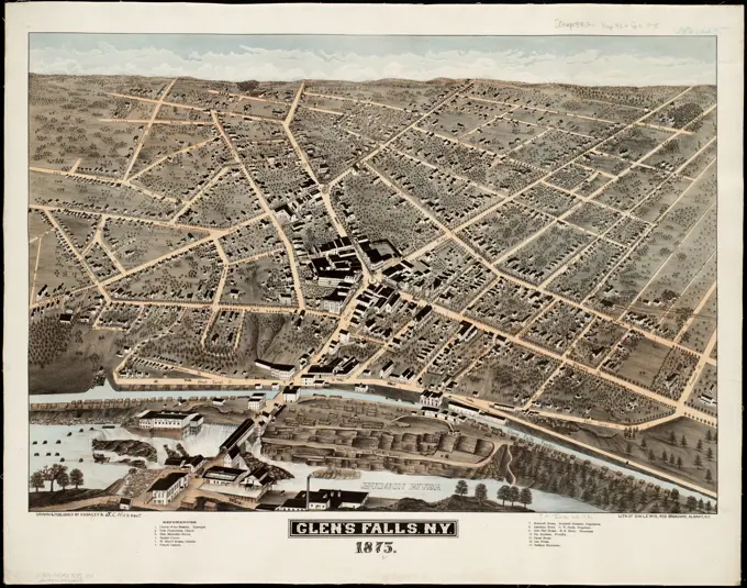
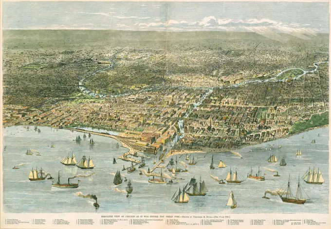
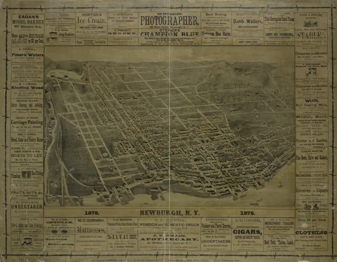
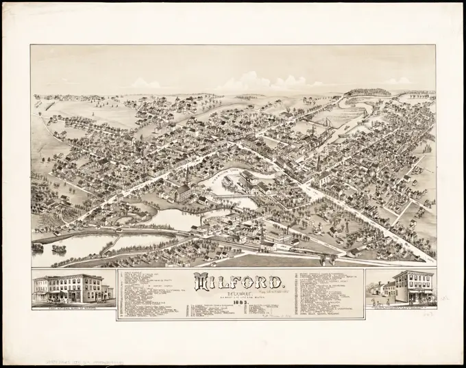
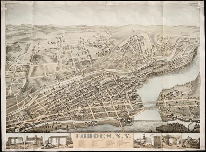
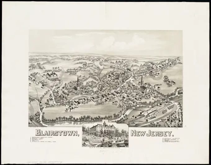
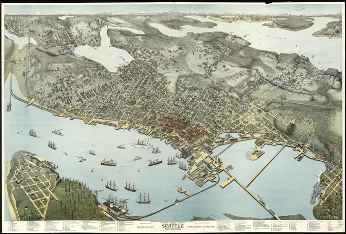
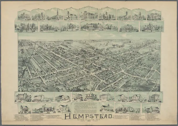
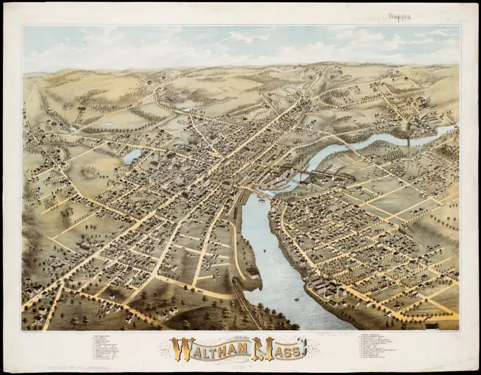
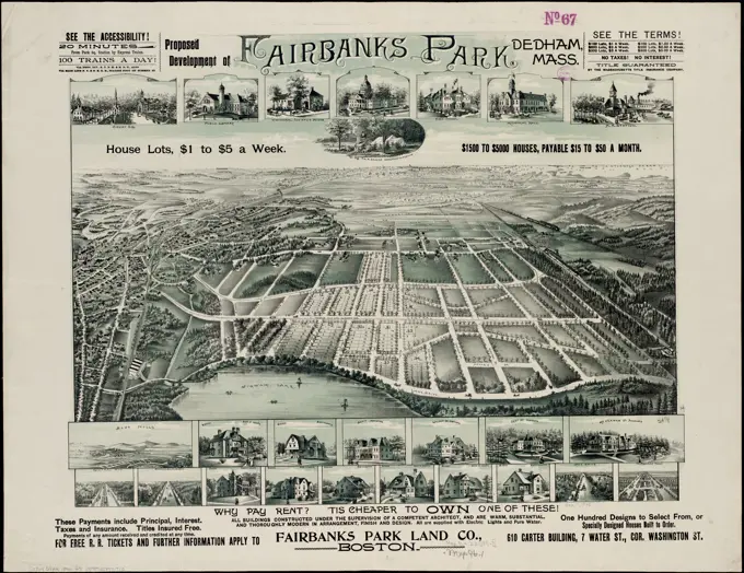
Aerial Views of Historical Towns

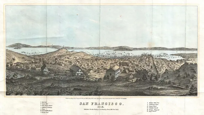
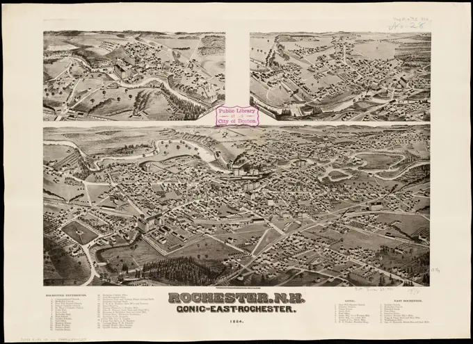
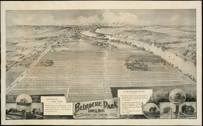
Illustrations of 19th-century towns in New England, featuring aerial views and detailed depictions of buildings and landscapes.

Weymouth, Mass., 1880 , Weymouth Mass., Aerial views Norman B. Leventhal Map Center Collection
Glens Falls, N.Y : 1875 , Glens Falls N.Y., Aerial views Norman B. Leventhal Map Center CollectionBirds eye view of the village of Wiscasset, Lincoln Co., Maine, 1878 , Wiscasset Me., Aerial views Norman B. Leventhal Map Center CollectionMilton, Pa , Milton Northumberland County, Pa., Aerial views Norman B. Leventhal Map Center CollectionMilton, Pa. Bird's-eye view. Includes index to points of interest and ill.... , Pennsylvania  , Northumberland  ,county   , MiltonWollaston, Massachusetts , Wollaston Quincy, Mass., Aerial views Norman B. Leventhal Map Center CollectionPlan of Lagoon Heights, Martha's Vineyard, Mass , Lagoon Heights Mass., Maps Norman B. Leventhal Map Center CollectionPlan of Lagoon Heights, Martha's Vineyard, Mass. Cadastral map showing lot lines and numbers. Oriented with north towards the upper left. "Aug. 1873." Includes 3 engraved vignettes.... , Massachusetts  , Dukes  ,county   , Martha's Vineyard  ,island   , Oak Bluffs  , Lagoon HeightsBelvidere : New Jersey. Bird's-eye view. Includes index to points of interest.... , New Jersey  , Warren  ,county   , BelvidereLawrence, Mass : 1876 , Lawrence Mass., Aerial views Norman B. Leventhal Map Center CollectionLawrence, Mass : 1876. Indexed for points of interest. "Printed by J. Knauber & Co." Bird's-eye view. "C.H. Vogt, Lith., Milwaukee, Wis."... , Massachusetts  , Essex  ,county   , LawrenceView of Holliston, Mass : 1878 , Holliston Mass., Aerial views Norman B. Leventhal Map Center CollectionView of Madison, Conn : 1881 , Madison Conn., Aerial views Norman B. Leventhal Map Center CollectionEastern Branch, National Home for Disabled Volunteer Soldiers, Togus, Me., 1885 , National Home for Disabled Volunteer Soldiers, Togus Me., Aerial views Norman B. Leventhal Map Center CollectionBird's eye view of Carbondale, Pa. Includes index to points of interest.... , Pennsylvania  , Lackawanna  ,county   , CarbondaleView of Canton, Mass : 1878 , Canton Mass., Aerial views Norman B. Leventhal Map Center CollectionBrodhead, Wis : 1871 , Brodhead Wis., Aerial views Norman B. Leventhal Map Center CollectionAero view of Canton, Mass. 1918. Bird's-eye view. Includes ill. and directory.... , Massachusetts  , Norfolk  ,county   , CantonVintage Lithograph Art: Map, The City of Chicago before the Fire.  1871View of Middletown, N.Y : 1874. Bird's-eye view. Includes index to points of interest, col. ill., and advertisements.... , New York  , Orange  ,county   , MiddletownA colored view of Newburgh, N.Y., issued in 1878 by H.H. Bailey & Co. The dimensions of the view are 52 x 81 cm, presented on a sheet measuring 86 x 111 cmDerry, New Hampshire , Derry N.H., Maps, Derry N.H., Aerial views Norman B. Leventhal Map Center CollectionWest Newton, Massachusetts , Newton Mass., Aerial views, West Newton Mass., Aerial views Norman B. Leventhal Map Center CollectionMilton, Pa , Milton Northumberland County, Pa., Aerial views Norman B. Leventhal Map Center CollectionBird's-eye view of Boston , Boston Mass., Aerial views Norman B. Leventhal Map Center CollectionCentreville and Artic Centre, Rhode Island , Arctic West Warwick, R.I., Aerial views, Centerville Kent County, R.I., Aerial views Norman B. Leventhal Map Center CollectionBradford, Massachusetts , Bradford Haverhill, Mass., Aerial views Norman B. Leventhal Map Center CollectionPlan of Falmouth Heights, Falmouth Mass., April 1st 1873 , Real property, Massachusetts, Falmouth Heights, Maps, Falmouth Heights Mass., Maps Norman B. Leventhal Map Center CollectionMilford, Delaware : 1885 , Milford Del., Aerial views Norman B. Leventhal Map Center CollectionSt. Stephen, New Brunswick and Calais, Maine : 1889 , St. Stephen N.B., Aerial views, Calais Me., Aerial views Norman B. Leventhal Map Center CollectionMiddleboro, Mass., 1881 , Middleboro Mass., Aerial views Norman B. Leventhal Map Center CollectionMiddleboro, Mass., 1881. Includes ill. Indexed for points of interest. Bird's-eye view... Middleboro, Massachusetts, 1881. Middleboro, Massachusetts, 1881, Massachusetts  , Plymouth  ,county   , MiddleboroHaverhill, Massachusetts. Birds-eye view from the southeast. Map bordered by individual images of many commercial buildings identified by name of owner or business as well as some churches and private homes. Includes index to points of interest. Statistics about Haverhill in upper margin. Businesses and important features listed to left and right of view. Business directory listing owner, industry and address in lower margin... Haverhill, Mass. the largest boot and shoe town in the world. Haverhill, Mass. the largest boot and shoe town in the world, Massachusetts  , Essex  ,county   , HaverhillPalisades of the Potomac, scenery unsurpassed : embracing the additions to Washington of Drovers Rest, White Haven, Toronto Heights, and River View, adjoining Washington and extending along the Potomac River on both sides of the Conduit Road for five miles to the Little Falls. 1890 AdvertisementWhitinsville, Massachusetts : 1891 , Whitinsville Mass., Aerial views Norman B. Leventhal Map Center CollectionCohoes, N.Y : 1879. Bird's-eye view. Relief shown pictorially. Incluldes index to points of interest and ill... Cohoes, New York, 1879. Cohoes, New York, 1879, New York  , Albany  ,county   , CohoesBridgewater, Massachusetts : 1887 , Bridgewater Mass., Aerial views Norman B. Leventhal Map Center CollectionFarm & Residences of W.F. Cooper, ESQ., M.D., Kelloggrille, Cayuga County., N.Y. Cartographic. Atlases, Prints. 1875. Lionel Pincus and Princess Firyal Map Division. Cayuga County (N.Y.), Real property , New York (State) , Cayuga CountyWest Newton, Massachusetts. Includes ill. Indexed for points of interest. Bird's-eye view.... , Massachusetts  , Middlesex  ,county   , Newton  , West NewtonWhitinsville, Massachusetts : 1891. Includes ill. Indexed for points of interest. Bird's-eye view.... , Massachusetts  , Worcester  ,county   , Northbridge  , WhitinsvilleBlairstown, New Jersey , Blairstown N.J., Aerial views Norman B. Leventhal Map Center CollectionThe city of New Haven, Conn : 1879 , New Haven Conn., Aerial views Norman B. Leventhal Map Center CollectionBlairstown, New Jersey , Blairstown N.J., Aerial views Norman B. Leventhal Map Center CollectionSouth Weymouth, Norfolk County, Mass. 1885 : from the fair grounds , Weymouth Mass., Aerial views Norman B. Leventhal Map Center CollectionBird's eye view of the city of Olympia, East Olympia and Tumwater, Puget Sound, Washington Territory, 1879 , Olympia Wash., Aerial views, Tumwater Wash., Aerial views Norman B. Leventhal Map Center CollectionNew Glasgow, Nova Scotia , New Glasgow N.S., Aerial views Norman B. Leventhal Map Center CollectionBirds-eye-view of Seattle and environs King County, Wash., 1891.  | Library of CongressView of Medway, Massachusetts : 1887 , Medway Mass., Aerial views Norman B. Leventhal Map Center CollectionView of Medway, Massachusetts : 1887. Bird's-eye view. Indexed for points of interest. Includes ill.... , Massachusetts  , Norfolk  ,county   , MedwayBird's eye view of Neenah, Wis : 1879 , Neenah Wis., Aerial views Norman B. Leventhal Map Center CollectionLansdale : Pennsylvania , Lansdale Pa., Aerial views Norman B. Leventhal Map Center CollectionView of Cheshire, Connecticut : 1882 , Cheshire Conn., Aerial views Norman B. Leventhal Map Center CollectionA bird's-eye view of theMississippi snaking itsway through the town ofNew Orleans, a town ofships and trade.Date: 19th centuryThe scene of successful Allied landings in southern France during the Second World War: a pictorial map from coasts to mountains.      Date: 1944Magnolia, Gloucester, Mass , Magnolia Gloucester, Mass., Aerial views Norman B. Leventhal Map Center CollectionGeneva, Wis : 1871. Bird's-eye view. Indexed for points of interest.... , Wisconsin  , Walworth  ,county   , Lake GenevaWest Medway, Massachusetts : 1887. Bird's-eye view. Includes index to points of interest and col. ill.... , Massachusetts  , Norfolk  ,county   , West MedwayHyde Park, Massachusetts : 1890 , Hyde Park Boston, Mass., Aerial views, Boston Mass., Aerial views Norman B. Leventhal Map Center CollectionHyde Park, Massachusetts : 1890 , Hyde Park Boston, Mass., Aerial views, Boston Mass., Aerial views Norman B. Leventhal Map Center CollectionThe city of Worcester, Mass : 1878 , Worcester Mass., Aerial views Norman B. Leventhal Map Center CollectionSouth Easton, Massachusetts : 1888 , South Easton Mass., Aerial views Norman B. Leventhal Map Center CollectionBirds eye view of Seattle and environs King County, Washington, 1891. Eighteen months after the Great Fire1856 Henry Bill Map and View of San Francisco, CaliforniaRochester, N.H : Gonic and East-Rochester, 1884 , Rochester N.H., Aerial views, Gonic Rochester, N.H., Aerial views, East Rochester Rochester, N.H., Aerial views Norman B. Leventhal Map Center CollectionBelvidere Park : Lowell, Mass. Shows ills. of homes and division of lots in a planned development.... , Massachusetts  , Middlesex  ,county   , LowellNashua, N.H : 1875. Bird's-eye view. "Printed by J. Knauber & Co." Indexed for points of reference. Oriented with north towards the bottom right.. Nashua, an industrial town located at the juncture of the Nashua and Merrimack Rivers in southern New Hampshire, was recorded on two birds eye views in less than ten years. The first was published in 1875 by Howard H. Bailey, and the second by his brother Oakley in 1883. In the former, Howard views the city from the north, giving prominence to two large textile mills, the Nashua Manufacturing Company on the right and the Jackson Manufacturing Companys Indian Head Mills on the left. These two industrial complexes, the largest employers in the city, were located on the Nashua River which is also strategically positioned flowing from right to left through the middle of the drawing. What makes this drawing especially interesting is the railroad station, labeled as the Concord and Union Depot and prominently displayed on the left side of the drawPittsfield, Mass , Pittsfield Mass., Aerial views Norman B. Leventhal Map Center CollectionNew Jersey Turnpike winding its way through Elizabeth , Roads, Cities & towns, Tichnor Brothers Collection, postcards of the United StatesView of Vicksburg and plan of the canal, fortifications & vicinity  | Library of CongressBelvidere Park : Lowell, Mass , Lowell Mass., Aerial views Norman B. Leventhal Map Center CollectionSouth New Market : Rockingham County, N.H. 1884 , Newfields N.H., Aerial views, South Newmarket N.H., Aerial views Norman B. Leventhal Map Center CollectionWest Medway, Massachusetts : 1887 , West Medway Mass., Aerial views Norman B. Leventhal Map Center CollectionBird's eye view of Concord, N.H : 1875 , Concord N.H., Aerial views Norman B. Leventhal Map Center CollectionSouth Easton, Massachusetts : 1888 , South Easton Mass., Aerial views Norman B. Leventhal Map Center CollectionPlat & environs of Lagoon Heights : showing property owned by the Lagoon Heights Land Co , Real estate development, Massachusetts, Lagoon Heights, Lagoon Heights Mass., Aerial views, Oak Bluffs Mass., Aerial views Norman B. Leventhal Map Center CollectionLunenburg, Nova Scotia , Lunenburg N.S., Aerial views Norman B. Leventhal Map Center CollectionHempstead, Long Island, N.Y. Cartographic. Maps, Aerial views. 1895. Lionel Pincus and Princess Firyal Map Division. Hempstead (N.Y.)View of Waltham, Mass , Waltham Mass., Aerial views Norman B. Leventhal Map Center CollectionView of Waltham, Mass. Bird's eye view. Indexed for points of interest. Printed by J. Knauber & Co.. Drawn from the southwest looking towards the northeast, this view of Waltham emphasizes the town's location straddling the Charles River. The central focus is a large industrial complex located on the river and identified as the Boston Manufacturing Company. Meanwhile the American Watch Company, also located on the river's edge, appears at the bottom center. This composition certainly directs attention to the town's two major industries. Located on the Charles River eight miles west of Boston, Waltham is often called the true birth place of America's Industrial Revolution. Although Waltham was incorporated as a separate town in 1738, it was primarily a farming community until 1814 when the location attracted the attention of Boston financier, Francis Cabot Lowell. After a journey to England inspecting industrial operations, he returned to Boston intending to construct a similar enterpriBoston Highlands, Massachusetts : Wards 19, 20, 21 & 22 of Boston , Boston Mass., Aerial views Norman B. Leventhal Map Center CollectionBoston Highlands, Massachusetts : Wards 19, 20, 21 & 22 of Boston. Bird's-eye view. Includes index to points of interest and ill.. While most bird's eye views of Boston depict the central city, this view looks toward the southwest, as if the artist was positioned above Washington and Shawmut Streets at the base of the original peninsula. Entitled Boston Highlands, it encompasses much of Roxbury, looking out toward Grove Hall, Franklin Park and Jamaica Plain. Often left out of 19th century maps and views of Boston, Roxbury was essentially Bostons backdoor. It served as the landward entrance to Boston and was especially important during the American Revolution. From a military perspective, it commanded the entrance to the narrow peninsula that connected British-occupied Boston to the mainland, which the colonists held. During the first half of the19th century Roxbury developed into a suburban community overtaking a rural, agricultural township that was established in 1630, at the same tiPlans. Appendix to the magazine Worker's friend, No 1 1898. Motif from the general art and industrial exhibition at Djurgården in Stockholm in 1897.Proposed development of Fairbanks Park, Dedham, Mass. Includes ill.... , Massachusetts  , Norfolk  ,county   , DedhamOverview map of New York City, 1879Prospects of London Before and After the Great Fire 1666 Wenceslaus Hollar Bohemian Two plates mounted together.. Prospects of London Before and After the Great Fire. Wenceslaus Hollar (Bohemian, Prague 1607-1677 London). 1666. Etching; second state of five. PrintsEast Bridgewater, Massachusetts : 1887. Includes ill. Indexed for points of interest. Bird's-eye view.... , Massachusetts  , Plymouth  ,county   , East BridgewaterEast Bridgewater, Massachusetts : 1887 , East Bridgewater Mass. : Town, Aerial views Norman B. Leventhal Map Center CollectionPoelzig Hans (1869-1936), settlement plan for Berlin-Lankwitz (1932): Perspective view (bird's show). Chalk on cardboard, 72.1 x 108.8 cm (including scan edges)Whiskey label of the Great Western Distilling Co., Peoria, Illinois., 1887-02-11Grandiose Project for a Super-Greater New York. cartographic. Clippings, Maps, Topographic maps. 1918. Science, Industry and Business Library: General CollectionTravel through Friesland, 1900 print. gameboard Board game with spiral with compartments numbered from 2 to 63. In midfield the rules of the game pressure and images of the city of Leeuwarden. In the 62 different city and village views in Friesland. Leeuwarden paper letterpress printing board-games of chance. board-games Friesland. Leeuwarden. Heerenveen. Sexbierum. Wolvega. Harlingen. Grouw. Bolsward. DrachtenAgricultural march ,. Graupner and early Boston Musical Scores plus Boston Music Hall EphemeraAgricultural march ,Inspection day at Blackville - Satirical look at African Americans, circa 1887