My Boards
View Pictures
  • My Boards

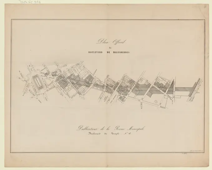
Architectural Design and Plans

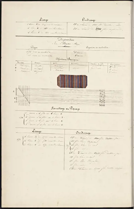
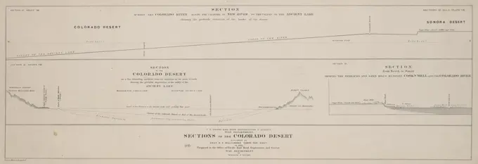
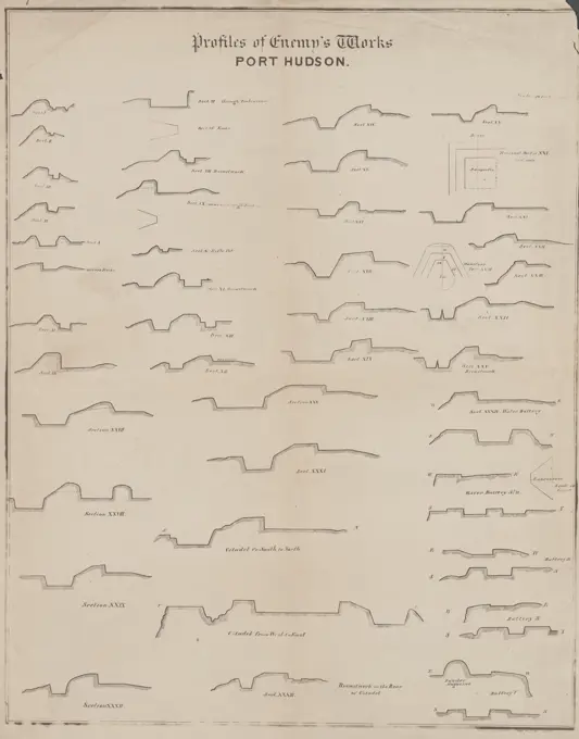
Detailed lithographs and plans showcasing various architectural projects, emphasizing structural designs and historical engineering techniques through precise drawings.

Plan of Tremont Street, from West to Boylston , Real property, Massachusetts, Boston, Maps, Manuscript, Streets, Massachusetts, Boston, Maps, Manuscript, Boston Mass., Maps, Manuscript Norman B. Leventhal Map Center Collection
173 assets in this story
6145-48491619
N.N., storage stations. (From: Atlas to the magazine for Building, ed. V. Ministry of Public Works, Jg. 52, 1902): Department, floor plans. Stitch on paper, 29.5 x 45.4 cm (including scan edges)
6145-52971737
Suggestions for rail, Åkers Styckbruk - Skottvång
6145-29929064
Official Plan of Boulevard Malesherbes // Publications of the Municipal Review
6145-48491622
N.N., storage stations. (From: Atlas to the magazine for Building, ed. V. Ministry of Public Works, Jg. 52, 1902): Department, floor plans. Stitch on paper, 29.6 x 45.5 cm (including scan edges)
6145-48453014
Linde Ernst, hydropower plant with shipping lock and tunnel. Prinzenkopf, Zell/Mosel. Schinkel competition 1904 (14.03.1904): Calculations for the cross -sections. Ink -colored watercolor on the box, 49.3 x 64.4 cm (including scan edges) Linde Ernst : Wasserkraftanlage mit Schifffahrtsschleuse und Tunnel. Prinzenkopf, Zell/Mosel. Schinkelwettbewerb 1904
6145-51939797
Drawing..
6145-54522592
New York (N.Y.). Croton Aqueduct Department. Cartographic, Maps. 1853. Lionel Pincus and Princess Firyal Map Division. New York (N.Y.), Reservoirs , New York (State) , New York Block No. 575 Map bounded by 91th Street, 5th Avenue, 90th Street, 6th Avenue
4443-22034211
French textile manuscript, ca. 1820, ca. 1820, an instruction manual for a school associated with a manufactory begins with a history of silk manufacture and continues with discussion of contemporary silk makers in Spain, Italy and France. The text is illustrated with 136 intricate drawings of looms, many in watercolor, showing set-ups for various patterns and materials, and includes 102 tipped-in examples of fabric. The chapters contain detailed information on silkworms and their breeding, the pulling of silk, and the composition of fashion materials, including gauze and damask.
6145-48453273
Müller Hermann, harbor railway with marshalling yard. Schinkel competition 1889 (1889): Viaduct. Powers plans. Ink, ink colored on cardboard, 64.6 x 47.1 cm (including scan edges) Müller Hermann : Hafenbahn mit Rangierbahnhof. Schinkelwettbewerb 1889
6145-55924811
Cartographic, Maps. 1857 - 1862. Lionel Pincus and Princess Firyal Map Division. Manhattan (New York, N.Y.), Real property , New York (State) , New York Plate 119: Map bounded by East 67th Street, First Avenue, East 62nd Street, Third Avenue
6145-42606228
Blunck Otto (1882-1919), connection between the right and left bank of the Rhine and the Ahrtalbahn. Schinkel competition 1909 (03/19/1909): Höhenplan 1: 10,000 (lengths), 1: 500 (heights). Ink, ink colored watercolor on the box, 38.2 x 65.5 cm (including scan edges) Blunck Otto  (1882-1919): Verbindung zwischen rechts- und linksrheinischer Bahn sowie der Ahrtalbahn. Schinkelwettbewerb 1909
6145-48453641
Fischer Friedrich, conversion of a channel with a steep descent and river port. Schinkel competition 1908 (20.03.1908): Depending plan of the level 3. 1: 1000. Ink, ink colored watercolor on the box, 63.3 x 94.4 cm (including scan edges) Fischer Friedrich : Umbau eines Kanals mit steilem Abstieg und Flusshafen. Schinkelwettbewerb 1908
6145-59606913
Map with the planeties for the year 1730, Anonymous, After Nicolaas Cruquius, 1729 - 1730 print Map with the planeties jobs for the year 1730. Under a table with the position of the planets per month. In the middle cards with the track of the planets.  paper engraving star-chart, star map
4443-75470868
A map titled 'Sections of the Colorado Desert,' explored by Lieut. R.S. Williamson in 1853. Issued by the U.S. War Department and the Office of Pacific Rail Road Surveys, the map features geological and survey details of California, specifically related to the Colorado Desert. The map is composed of three sections on one sheet, measuring 10 x 70 cm or smaller, presented on a larger sheet measuring 28 x 74 cm
6145-48487463
N.N., Neißebrücke (rage bridge), Nieder Bielau: site plan 1: 2000, view, floor plans, cuts 1: 1200, 1: 100, details 1:20. Lithograph on paper, 46.4 x 83.9 cm (including scan edges) N.N. : Neißebrücke (Wuthebrücke), Nieder Bielau
6145-42604496
Plock Carl (born 1851), warehouses and Packhof for Berlin. Schinkel competition 1880 (1880): warehouse system: floor plan basement, ground floor, 1st floor, 2nd floor 1: 100; Scale bar. Tusche watercolor on the box, 47.7 x 194.7 cm (including scan edges) Plock Carl  (geb. 1851): Lagerhäuser und Packhof, Berlin. Schinkelwettbewerb 1880
6145-48484041
N.N., comparison of locks and mechanical lifts. (From: Atlas to the magazine for Building, ed. V. Ministry of Public Work, Jg. 56, (1906-1906): Graphics. Pressure on paper, 29.6 x 46 cm (incl. Scan edges) N.N. : Vergleich von Schleusen und mechanischen Hebewerken. (Aus: Atlas zur Zeitschrift für Bauwesen, hrsg. v. Ministerium der öffentlichen Arbeiten, Jg. 56, 1906)
6176-66088129
Westkapelle City Levee Map. Netherlands, Europe. Trip to the Zeeland by Charles De Coster 1873
6145-42605177
Unknown architect, falling in Neisse. Monthly competition January 1872 (01.1872): site plan, floor plan; 2 scale strips. Tusche watercolor on the box, 80.5 x 58.9 cm (including scan edges) N.N. : Gefallenendenkmal, Neiße. Monatskonkurrenz Januar 1872
6145-46742638
Large copper mountain chronology. Mining maps.ur Carl Sahlin's mountain historical collection.
6145-42626656
N.N., jetty for the fiscal steam ferry near Kaseburg, Swinemünde: cuts 1: 150. Lithograph on paper, 32.8 x 62.4 cm (including scan edges)
4443-75476052
Profiles of enemy's works at Port Hudson, issued in 1863 by the United States Army Department of the Gulf. The document is a photocopy measuring approximately 56 x 44 cm and consists of about 46 sections on one sheet. It pertains to the Civil War (1861-1865) and includes details related to fortifications in Louisiana, specifically at Port Hudson. The place of issue is New Orleans, Louisiana
6145-54549601
Hinmansville Village; Hinmansville Business Directory; Gilbertsville Village; Scriba Corners Village; Scriba Business Directory; Mallory's Mills Business Directory; Mallory's Mills P.O. Village Cartographic. Atlases, Maps. 1867. Lionel Pincus and Princess Firyal Map Division. Oswego County (N.Y.), Real property , New York (State) , Oswego County, Business enterprises , New York (State) , Oswego County
6145-43536409
Print (France)
6145-48453554
Gerlach Friedrich (1856-1938), port and channel facility in Berlin-Gesundbrunnen (north Canal). Schinkel competition 1886 (June 18, 1886): Ufer sections: Uferstrasse, bank walls. Cuts 1: 100, 1:20. Ink, ink colored, watercolor on cardboard, 52 x 68.1 cm (including scan edges) Gerlach Friedrich  (1856-1938): Hafen- und Kanalanlage, Berlin-Gesundbrunnen (Nordkanal). Schinkelwettbewerb 1886
6145-44022636
The principles of architecture.
6145-42639941
Rohlfing, provisamt, Cologne. Machine facilities (approx. 1907): floor plan DG 1: 100. Lithograph, 52 x 82 cm (including scan edges)
6145-48484009
N.N., protective buildings on the North and East Frisian Islands. (From: Atlas to the magazine for Building, ed. V. Ministry of Public Work, Jg. 55, (1905-1905): site plan, cuts. Pressure on paper, 29.5 x 45.7 cm (incl. Scan edges) N.N. : Schutzbauten an den Nord- und Ostfriesischen Inseln. (Aus: Atlas zur Zeitschrift für Bauwesen, hrsg. v. Ministerium der öffentlichen Arbeiten, Jg. 55, 1905)
6145-42624070
N.N., fastening of the western beach, Norderney: Expansion of the grave E: cuts 1: 250. Lithograph on paper, 32.2 x 63.1 cm (including scan edges) N.N. : Befestigung des Weststrandes, Norderney
6145-48448007
Jansen Hermann (1869-1945), development plan in Berlin-Gatow and Berlin-Kladow (November 7, 1942): Road profiles 1: 500. Pencil and ink on transparent, 64.3 x 107.3 cm (including scan edges) Jansen Hermann  (1869-1945): Bebauungsplan Berlin-Gatow und Berlin-Kladow
6145-43862125
Brookline Water Works : profile of main pipe from engine house to reservoir , Underground pipelines, Massachusetts, Brookline, Maps, Brookline Mass., Maps Norman B. Leventhal Map Center Collection
6145-42621685
N.N., Road Bridge over the Elbe, Torgau: View, floor plan 1: 200. Lithograph on paper, 63.9 x 103.3 cm (including scan edges) N.N. : Straßenbrücke über die Elbe, Torgau
6145-43860541
Gulf of Pechelee, China, Great Wall and town of Shaw-hai-wei in lat. 40.4 N. - lon. 120.2 E. , Bo Hai China, Aerial views, Great Wall of China China, Aerial views, Suizhong Xian China, Aerial views Norman B. Leventhal Map Center Collection
6145-48482744
N.N., Learning of the Troisdorf-Niederlahnstein railway line. Reception building, Vallendar. (From: Atlas to the magazine for Building, ed. V. Ministry of (1890-1890): Location plans, cuts, floor plan Vallendar. Lithograph on paper, 29.8 x 46.3 cm (incl. Scan edges) N.N. : Höherlegung der Bahnstrecke Troisdorf-Niederlahnstein. Empfangsgebäude, Vallendar. (Aus: Atlas zur Zeitschrift für Bauwesen, hrsg. v. Ministerium der öffentlichen Arbeiten, Jg. 40, 1890)
6145-42626443
N.N., turning bridge over the fiscal harbor canal, Elbing: site plan 1: 1000, cut 1: 500, 1:50. Lithograph colored on paper, 42.5 x 31.8 cm (including scan edges)
4443-75463360
Map showcasing 150 lots of ground located in the eleventh ward of New York, pertaining to the estate of John Flack, deceased. The map is hand-colored, measuring 30 x 45 cm, and was issued in 1833. It features details related to landownership and real property in Manhattan, New York
4443-73237945
Roeder, Johann Christoph de, Northern Netherlands, Positions of the Dutch and English ships at the naval battle at Doggersbank, 1781 (plate II), verso - stamped, Positions of the Dutch and English ships at Doggersbank on 5 August 1781 between the Dutch fleet under Rear Admiral Johan Zoutman and the English fleet under Vice Admiral Hyde Parker. Plate II with figures 6-8. In the caption the legend with the names of the warships involved., print, prent, prints, prenten, Frederik Muller Historieplaten, height 195 mm, width 278 mm, print maker, prentmaker, 1781 - 1783, paper, papier, etching, etchings, engraving, engraving (printing process), hand coloring, intermediary draughtsman
6145-48454386
Dirksen Friedrich (died 1907), main train station in Leipzig. Schinkel competition 1899 (04.05.1900): locking board: track plan. Layout. Ink, ink colored watercolor on the box, 42 x 101.6 cm (including scan edges) Dircksen Friedrich  (gest. 1907): Hauptbahnhof, Leipzig. Schinkelwettbewerb 1899
6145-48487860
N.N., fastening of the western beach, Norderney: Expansion of the grave C: cuts 1: 250. Lithograph on paper, 44.2 x 63.1 cm (including scan edges) N.N. : Befestigung des Weststrandes, Norderney
6145-42606045
GERECKE Paul, bridge channel over the Weser for the Rhine-Egg Canal near Minden. Schinkel competition 1905 (March 15, 1905): Long -distance cut of the canal line, cuts 1: 1000, 1: 200, 1: 100. Ink, ink colored watercolor on the box, 50.1 x 130.4 cm (including scan edges) Gerecke Paul : Brückenkanal über die Weser für den Rhein-Elbe-Kanal bei Minden. Schinkelwettbewerb 1905
6145-48487304
N.N., Dortmund-Ems-Canal. Schleuse, Münster: cuts 1: 100. Lithograph colored on paper, 50.4 x 70.2 cm (including scan edges) N.N. : Dortmund-Ems-Kanal. Schleuse, Münster
6145-48484170
N.N., size of the water pressure in the ground. (From: Atlas to the magazine for Building, ed. V. Ministry of Public Works, Jg. 61, 1911) (1911-1911): Graphics. Print on paper, 29.6 x 45.8 cm (including scan edges) N.N. : Größe des Wasserdrucks im Boden. (Aus: Atlas zur Zeitschrift für Bauwesen, hrsg. v. Ministerium der öffentlichen Arbeiten, Jg. 61, 1911)
6145-44030963
Masonry, foundations, ideal representation, cuts
6145-48456928
Havestadt, Contag & Uthemann, railway bridge in Venezuela. Monthly competition February 1889 (02.1889): Details on the pillars 1:25; Scale bar. Ink on cardboard, 44.4 x 58.6 cm (including scan edges) Havestadt, Contag & Uthemann : Eisenbahnbrücke in Venezuela. Monatskonkurrenz Februar 1889
6145-48502729
test111
6145-50552927
Map showing branches of chartered banks in Manitoba, Saskatchewan and Alberta , Banks and banking, Prairie Provinces, Maps, Railroads, Prairie Provinces, Maps, Prairie Provinces, Commerce, Maps, Manitoba, Maps, Saskatchewan, Maps, Alberta, Maps Norman B. Leventhal Map Center Collection
6145-55167249
Map showing branches of chartered banks in Manitoba, Saskatchewan and Alberta. Includes index to chartered banks. Also shows railroads... Chartered banks in Manitoba, Saskatchewan and Alberta. Chartered banks in Manitoba, Saskatchewan and Alberta, Canada  , Prairies  ,area
6145-42627664
N.N., Rhein-Herne-Canal. Schleuse 1, Duisburg-Meiderich: Chamber walls: cross-sections 1: 100. Lithograph on paper, 73.6 x 102.9 cm (including scan edges)
6145-43790803
Wachusett Reservoir, maximum section of dam, engineering plan, Clinton, Mass., ca. 1900 , waterworks, dams, engineering maps
6145-42620751
N.N., Oder-Spree Canal. Route Seddinsee to Große Tänke (02.1890): Stat. 22.0 - 24.0: site plan 1: 2500. Lithograph on paper, 46.8 x 65 cm (including scan edges) N.N. : Oder-Spree-Kanal. Strecke Seddinsee bis Große Tränke
6145-55920510
Route Map and Profile of the Alaska Highway. State: Alaska.
6145-48502767
test111
6145-55179047
Griechisch-Demotische Inschriften. Gr. 8, Dem. 180: Alabasterstele aus Kâhira jetzt im K. Museum zu Berlin. Forsetzung auf Blatt 74.. Eirund, E.. 1849 - 1856. Lepsius, Richard, 1810-1884. Prints. General Research Division. Egypt , Antiquities, Egyptian language , Inscriptions, Stelae, Egyptian language , Demotic, ca. 650 B.C.-450 A.D, Inscriptions, Greek
6145-48489395
N.N., towing gate at the jigsome, Riebnig: bank attachment: cuts 1: 100. Lithograph on cardboard, 31.4 x 39.2 cm (including scan edges)
6145-59228894
Explanation at the print face of the sea battle at Copenhagen, Anonymous, After Peltro William Tomkins, 1801 print  England paper etching battle. ships (in general) Copenhagen (city)
6145-48616906
Wachusett Reservoir, maximum section of dam, engineering plan, Clinton, Mass., ca. 1900 , waterworks, dams, engineering maps
6145-48454873
Koss Achmed (1887-1914), port system for Gdansk-Neufahrwasser. Schinkel competition 1914 (14.03.1914): port entrance. Site plan 1: 5000. Ink, ink colored watercolor on the box, 49.6 x 70.6 cm (including scan edges) Koss Achmed  (1887-1914): Hafenanlage, Danzig-Neufahrwasser. Schinkelwettbewerb 1914
6145-50518304
Sections of soundings made by order of the Harbor Committee of 1852 , Boston Harbor Mass., Maps Norman B. Leventhal Map Center Collection
6145-48483950
N.N., Studies on the flow effect. (From: Atlas to the magazine for Building, ed. V. Ministry of Public Work, Jg. 54, 1904) (1904-1904): cuts, graphics. Print colored on paper, 29.6 x 45.8 cm (including scan edges) N.N. : Untersuchungen zur Strömungswirkung. (Aus: Atlas zur Zeitschrift für Bauwesen, hrsg. v. Ministerium der öffentlichen Arbeiten, Jg. 54, 1904)
6145-48502730
test111
6145-42603556
Jansen Hermann (1869-1945), Bamberg development plan (1929-1929): Length profiles 1: 2000, 1: 200. Light break watercolored on paper, 34.1 x 84.5 cm (including scan edges) Jansen Hermann  (1869-1945): Bebauungsplan Bamberg
6145-29669773
Photo collection Government information service. Cross section of a polder. undated
6145-55167758
U.S.S. George Washington Dec. 4, 1917 - Dec. 23, 1918. Shows tracks for trips 1-7 and 10 of the U.S.S. George Washington in the North Atlantic Ocean.... , Atlantic Ocean
6145-44128680
Bl. 02: Character statement, 1889
6145-51942381
Drawing.Found in office of Marine Museum's curator his linen.
6145-48717865
Sections of soundings made by order of the Harbor Committee of 1852 , Boston Harbor Mass., Maps Norman B. Leventhal Map Center Collection
6145-50557048
A new map of the Hudson River : the post roads between N. York & Albany, the northern and western canals, &c., &c , Hudson River N.Y. and N.J., Maps, Hudson River Valley N.Y. and N.J., Maps Norman B. Leventhal Map Center Collection
6145-42604352
Unknown architect, St. Catharinen-Kirche, Braunschweig. () (Without Dat.): Grundriss scale bar (Brschw. Werk Foot). Print on paper, 20.3 x 33.8 cm (including scan edges) N.N. : St. Catharinen-Kirche, Braunschweig ()
6145-29621992
Collection of the Dutch Heidematschappij. Development and construction of the low and peat. undated
6145-48719815
Radiotelegraph and radiotelephone communication systems of France : radiotelegraph communication system of the French Ministry of Post, Telegraph and Telephone , Telegraph, France, Maps, Telephone, France, Maps, Telecommunication, France, Maps Norman B. Leventhal Map Center Collection
6145-42603125
Barth Erwin (1880-1933), orchard passage (02.10.1925): Obstauga duct in floor plan 1: 100, partial side view and cross-section 1:50, with dimension. Pencil on transparent, 22.1 x 42.1 cm (including scan edges) Barth Erwin  (1880-1933): Obstlaubengang
6145-48474311
Böhmer Franz (1907-1943), Waldbühne in Grünberg (08.1935): floor plan spectator 1: 100. Pencil on transparent, 54 x 54.1 cm (including scan edges)
6145-29915735
La France / statistics and etulatorale / de 1831 à 1851 (TI)
PREVIOUS
of 2
NEXT
2401 S. Ervay, Suite 206
Dallas, Texas 75215
United States
Get Started
Free ResearchMy BoardsMy Cart
For Creators
How To License Your ContentContributor PortalFrame of Mind
Resources
API accessPricing
Contact
+1 866 236 0087help@viewpictures.co.uk Contact form
©2026 View Pictures. All Rights Reserved. -A
This site is protected by reCAPTCHA and Google Privacy Policy and Terms of Service apply.