My Boards
View Pictures
  • My Boards

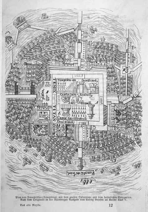
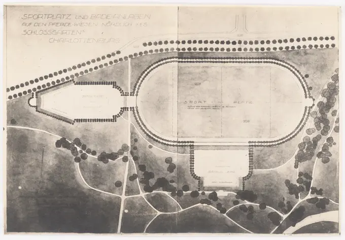
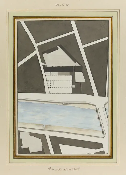
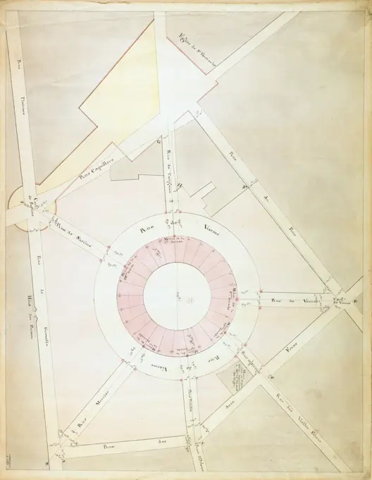
Architectural Plans and Maps

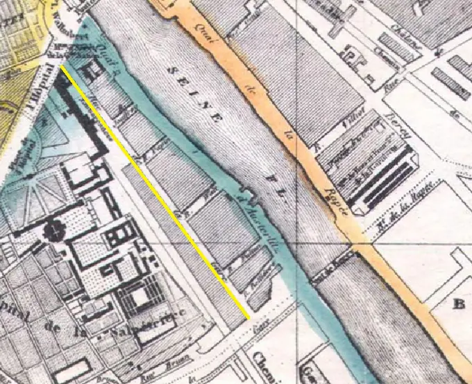
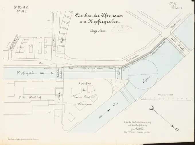
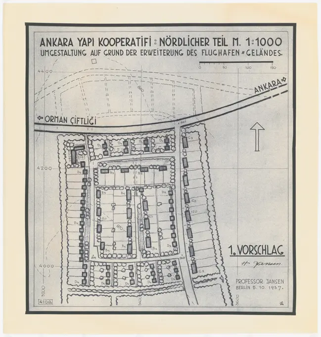
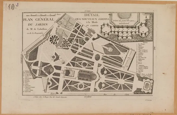
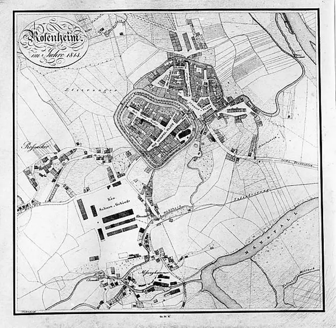
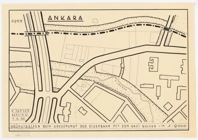
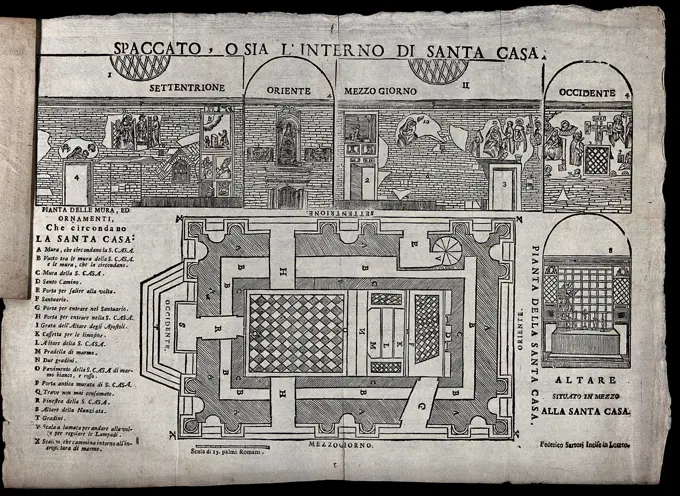
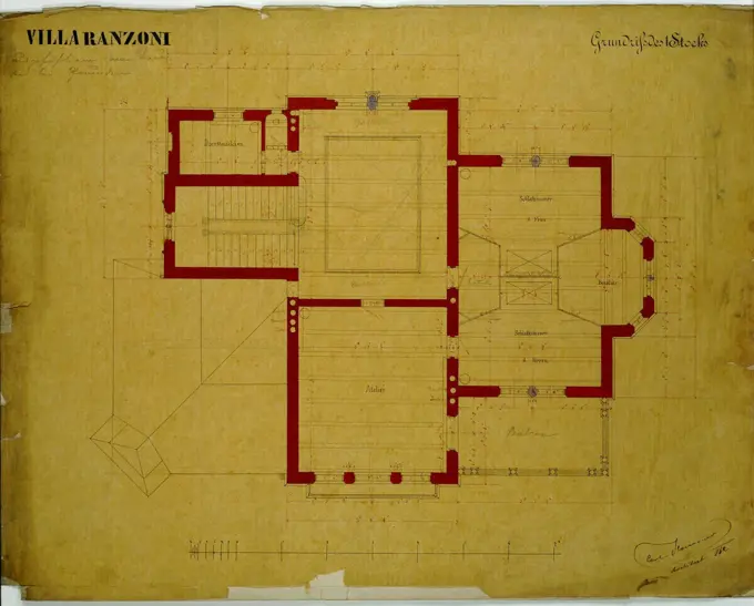
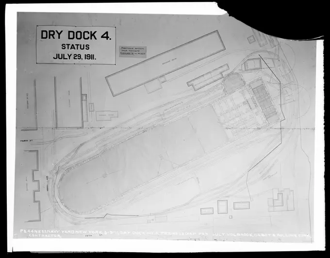
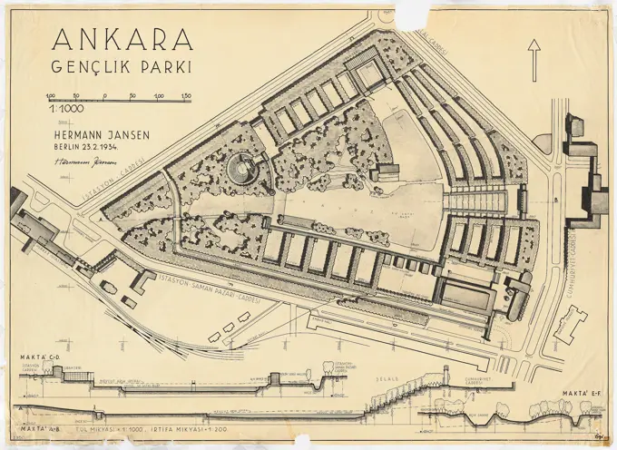
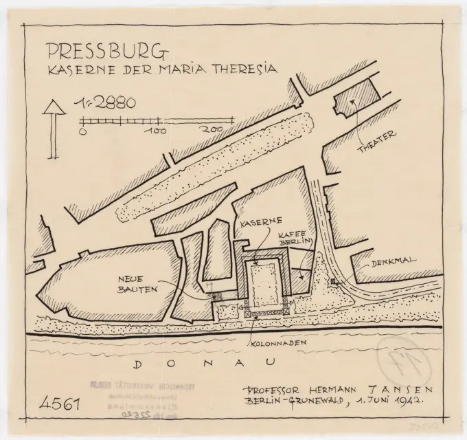
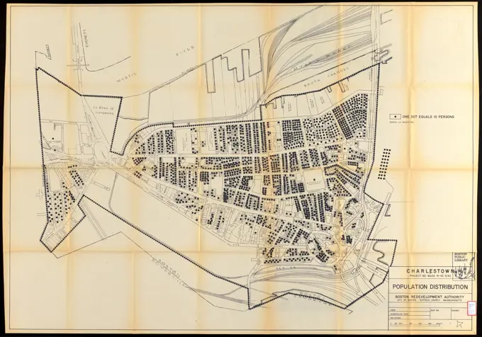
Detailed architectural drawings and site plans from the early 20th century, illustrating building layouts and urban developments in various locations.

Charlestown project no. Mass r-42 (GN) : population distribution , Charlestown Boston, Mass., Maps, City planning, Massachusetts, Boston, Maps, Population density, Massachusetts, Boston, Maps, Urban renewal, Massachusetts, Boston, Maps
279 assets in this story
6145-29095963
Rue de la Gare 1865
6145-48463229
Unknown architect, harbor building yard, Swinemünde (approx. 1891): site plan 1: 1000. Lithograph on paper, 47.8 x 69.1 cm (including scan edges) N.N. : Hafen-Bauhof, Swinemünde
1746-111354513
Woodcut engraving depicting a 15th century plan of Canterbury. Dated 15th century
6145-50567482
Rose F. Kennedy Garden , City planning, Massachusetts, Boston, Maps, Rose gardens, Massachusetts, Boston, Maps, Boston Mass., Maps Norman B. Leventhal Map Center Collection
6145-48487489
N.N., bank wall at Kupfergraben, Berlin: site plan 1: 1000. Lithograph colored on paper, 31.9 x 42.7 cm (including scan edges) N.N. : Ufermauer am Kupfergraben, Berlin
6145-59599800
Map of the Botanical Garden, in Oxford, Anonymous, 1707 print Imagined at the top right: p. 593.  paper etching Botanic Garden, 'Hortus Botanicus' Oxford
6145-48447676
Jansen Hermann (1869-1945), total development plan Ankara. Partial development plan inner city (October 18, 1937): Department 1: 500, Halk Firkasi Evi (People's Party building), 2nd project, (light break from Inv.No. 22827). Colored pencil over a break on paper, 45.1 x 50.9 cm (including scan edges) Jansen Hermann  (1869-1945): Gesamtbebauungsplan Ankara. Teilbebauungsplan innere Stadt
6145-42603959
Unknown architect, Rome. The project belongs: Hermann Jansen, development plan of the city expansion (January 13, 1921): Blatt 2nd break on paper, 32.2 x 49.4 cm (including scan edges) N.N. : Rom. Zum Projekt gehörend: Hermann Jansen, Bebauungsplan der Stadterweiterung
6145-48473819
Böhmer Franz (1907-1943), weekend hotel and lido (1933-1933): weekend hotel: floor plan ground floor 1: 200. Ink on transparent, 74.6 x 99.1 cm (including scan edges)
6145-48716127
L'Acropole D'Athenes d'après I. A. Kaupert , Forts & fortifications, Maps. Nicholas Catsimpoolas Collection
6145-51939859
Drawing..
6145-48478268
Neckelmann Skjold (1854-1903), Theater in Cologne (1898): site plan (variant) 1: 200. Ink, ink colored on cardboard, 73.4 x 102.4 cm (including scan edges)
6145-30111423
Foundation of the Engelenburcht and the Engelenbrug in Rome; Archaeological finds in and around Rome; Le Antichità Roman.The Foundation of the Engelenburcht and the Engelenbrug in Rome. Explanatory List or letters in the sub-margin. Numbered Above: Tom. IV. / Vi.
4409-21359295
PLANO DEL BARRIO DE ARGÜELLES-SIG 0,49-1-20. Location: ARCHIVO HISTORICO DE LA VILLA, SPAIN.
6176-66079204
Old map of the Factory and the City of Creusot, France. Europe. Le Creusot et les mines de Saone-et-Loire, 1865 by Louis Laurent Simonin (1830-1886)  Le Tour du Monde 1867
6145-50444320
Jansen Hermann (1869-1945), total development plan Ankara. Settlement Bahceli Evler Yapi Cooperifi (05.10.1937): (Light break from Inv.No. 23085), basic and location plan 1: 1000 northern section, 2nd project phase, new version, 1st suggestion. Light break on paper, 69.2 x 66.1 cm (including scan edges) Jansen Hermann  (1869-1945): Gesamtbebauungsplan Ankara. Siedlung Bahceli Evler Yapi Kooperatifi
6145-50560328
L'Acropole D'Athenes d'après I. A. Kaupert , Forts & fortifications, Maps. Nicholas Catsimpoolas Collection
6145-30305713
Model of the so -called large settlement on the Eichkogel also, wooden levy settlement
6145-29927223
General Plan of the Garden of M. de Labosière or Bouxiere.
6145-48716128
L'Acropole D'Athenes d'après I. A. Kaupert , Forts & fortifications, Maps. Nicholas Catsimpoolas Collection
6145-43491962
Photostat, Floor Plan for the First Floor of the Home of Hector Guimard, 22 Rue Mozart; Architect: Hector Guimard ((French, 1867-1942)); France; photostat, pen and brown ink on paper; 42.8 x 34.5 cm (16 7/8 x 13 9/16 in.), irregular
4220-1163
Cortes' plan of Tenochtitlan.
6145-48444842
Barth Erwin (1880-1933), sports and bathing facilities on the horse meadows at the Schlossgarten Berlin-Charlottenburg (09.1920): Sports facility in the floor plan with an surrounding park 1: 500, scale bar, designation of individual parts. Photo on paper, 17 x 24.4 cm (including scan edges) Barth Erwin  (1880-1933): Sport- und Badeanlagen auf den Pferdewiesen beim Schlossgarten Berlin-Charlottenburg
6145-48447964
Jansen Hermann (1869-1945), partial development plan of the Goslar city expansion. At Köppelsbleek (January 20, 1926): Department 1: 1000. Ink and pencil on transparent, 35.6 x 47.8 cm (including scan edges) Jansen Hermann  (1869-1945): Teilbebauungsplan der Stadterweiterung Goslar. Am Köppelsbleek
6145-50443742
Barth Erwin (1880-1933), expansion of the cemeteries in Stolp/Pomerania (05.1930): 41169: Floor plan of the northwestern part of the planned expansion of the cemetery with height lines and planning as well. Ink colored, watercolored, over a break on the box, 118 x 93.8 cm (including scan edges) Barth Erwin  (1880-1933): Erweiterung der Friedhöfe, Stolp
6145-30306796
Structural plan of a planned settlement in Veitsch Stmk,
6145-48447707
Jansen Hermann (1869-1945), total development plan Ankara. Partial development plan for government district (November 28, 1934): Department 1: 1000, government district, terrace with garages on Vilayet-Platz. Ink on transparent, 26.6 x 31.5 cm (including scan edges) Jansen Hermann  (1869-1945): Gesamtbebauungsplan Ankara. Teilbebauungsplan Regierungsviertel
6145-42608222
Encke Friedrich August (1861-1931), Garten Hagen, Birlinghoven Castle, St. Augustin (March 24, 1919): Deport plan Flower and Rose Gardens 1: 200. Light break on paper, 48.2 x 69.9 cm (including scan edges)
6145-29860925
Helen Miller, Rutgers Estate and Garden, c 1936 Rutgers Estate and Garden
6145-50443911
Unknown architect, garden in Burscheid (approx. 1906-1908): Gardening in the floor plan 1: 625. Blue on the box, 37.1 x 49.7 cm (including scan edges) N.N. : Garten Ispert, Burscheid
6145-30219938
Poultry Market Map Pierre-Fran�ois-L�onard Fontaine (1762-1853). Poultry Map. Feather, Chinese ink and lavis blue.
4443-21725750
Map of Hellevoetsluis, ca. 1701-1715, Samuel Du Ry de Champdoré, 1701 - 1715, Map of the fortifications around the town of Hellevoetsluis, ca. 1701-1715. Bottom left a cartouche with the legend A-H in Dutch, carried on the shoulders by a sea god. Part of a collection of drawn plans of fortified towns in the Netherlands and surrounding countries at the time of the War of the Spanish Succession (Part A)., draughtsman: Samuel Du Ry de Champdoré, Netherlands, 1701 - 1715, paper, h 482 mm × w 620 mm
6145-30195103
Map of the old wheat hall Anonymous. Map of the old wheat hall. Feather, black ink, watercolor wash.
6145-52976944
Plan over the yard
6145-59591156
Map of Beverwijk, Anonymous, 1657 - 1690 print Map in a nutshell perspective. At the top left the Wapen van Beverwijk. At the bottom right a cartouche with the title, a legend 1-8 and a bowl: 240 pedes geometrici.  paper etching / engraving maps of cities. coat of arms (as symbol of the state, etc.) (+ city; municipal) Beverwijk
4409-17299341
PLANO DE ZONA DE MADRID SIG 10-84-91 19/7/1864 (DET 69915). Author: CARLOS MARIA DE CASTRO (1810-1896). Location: ARCHIVO HISTORICO DE LA VILLA. MADRID. SPAIN.
6145-50444305
Jansen Hermann (1869-1945), total development plan Ankara. Partial development plan for government district (09.08.1938): site plan, profile 1: 2000, expansion of the systems of the government district. Ink on transparent, 44.3 x 49.4 cm (including scan edges) Jansen Hermann  (1869-1945): Gesamtbebauungsplan Ankara. Teilbebauungsplan Regierungsviertel
1848-61753309
The ground plan of Wartburg Castle in Thuringia in the 11th century, Germany, digitally restored reproduction of a 19th century original, exact original date unknown, Europe
6145-45870058
Map of Heusden, ca. 1701-1715; Heusden. Map of the reinforcements around the city of Heusden, ca. 1701-1715. At the bottom left of a cartouche with the legend A-i in Dutch, with four putti with passers. Part of a collection of signed plans of reinforced places in the Netherlands and surrounding countries at the time of the Spanish Succession War (Part A).
6145-55952101
Plan of the Fort at Pensacola, 1764. Copy from the original in the War Office records, Caxton House, London, number Z/30/2. Robertson, Archibald, approximately 1745-1813. 1764. Drawings, Plans. Spencer Collection. Armies , British , To 1799, Military officers , Personal narratives, War in art, United States , History , Revolution, 1775-1783, Campaigns & battles, Forts & fortifications, Pensacola (Fla.)
6145-29621048
Collection of the Dutch Heidematschappij. Drawings, floor plans. undated. Gelderland, Wageningen
6145-30311534
, Alter Naschmarkt, Karlsplatz, Wienzeile and other parts of Wieden, flying, postcard, Verlag Luftbiew Ges, Producer
4409-21514942
Recortable infantil. Construcción de barcos. Submarino. Recortables Baby. Barcelona, año 1936.
4409-17518059
Plattegrond van Geertruidenberg, ca. 1701-1715. Geertruydenberg (title on object). Draughtsman: Samuel Du Ry de Champdoré. Dating: 1701 - 1715. Place: Netherlands. Measurements: h 482 mm × w 620 mm. Museum: Rijksmuseum, Amsterdam.
6145-51396729
Back Bay Fens master plan , Parks, Massachusetts, Boston, Maps, City planning, Massachusetts, Boston, Maps, Urban renewal, Massachusetts, Boston, Maps, Fenway Boston, Mass., Maps Norman B. Leventhal Map Center Collection
1848-50214036
Plan of the city of Rosenheim silver hake (1814), Upper Bavaria, Bavaria, Germany, Europe
6145-50445713
Brix & Genzmer, Groß-Berlin 1910 competition. Extension of the Technical University of Berlin-Charlottenburg (1908-1910): Department: Knesebeckstraße after Kurfürstenallee and extension of the Technical University. Print, 48.6 x 55.7 cm (including scan edges)
6145-48447696
Jansen Hermann (1869-1945), total development plan Ankara. Partial development plan exterior (07.03.1932): Basic plan 1: 2000, area east of Gazi Mustafa Kemal Caddesi. Ink on transparent, 26.1 x 36.7 cm (including scan edges) Jansen Hermann  (1869-1945): Gesamtbebauungsplan Ankara. Teilbebauungsplan äußere Stadt
6145-46485798
Forting floor of Gouda; Gouda. Map of Gouda. Above the city's arms, at the top right of a German legenda 1-10. Bottom left a scaling stick: 480 pedes geometrics.
6145-48434891
Thür Georg (1846-1924), Physical Institute of the University of Göttingen (1903-1905): site plan 1: 200. Lithograph, 61 x 60.8 cm (including scan edges)
6145-50444254
Jansen Hermann (1869-1945), Planning for Plowdiw (02.1943): District between Zar-Simeon-Platz and Prespassstraße, site, cuts, views 1: 1000, road profile 1: 250. Ink on transparent, 71 x 72.1 cm (including scan edges) Jansen Hermann  (1869-1945): Planung für Plowdiw
6145-50570303
Atlas of the county of Suffolk, Massachusetts : vol. 6th including the late city of Charlestown, now wards 20,21 and 22, city of Boston : from actual survey & official records : plate E , Real property, Massachusetts, Boston, Maps, Landowners, Massachusetts, Boston, Maps, Charlestown Boston, Mass., Maps Norman B. Leventhal Map Center Collection
6145-45870336
Map of Klundert, ca. 1701-1715; Clunder. Map of the reinforcements around the city of Klundert, ca. 1701-1715. At the bottom right a cartouche with the legend A-H in Dutch, with two putti hunting on a hare. Part of a collection of signed plans of reinforced places in the Netherlands and surrounding countries at the time of the Spanish Succession War (Part A).
6145-59132724
Campania Caserta Sessa Aurunca Porta Capuccini. Hutzel, Max 1960-1990 Medieval: Architecture German-born photographer and scholar Max Hutzel (1911-1988) photographed in Italy from the early 1960s until his death. The result of this project, referred to by Hutzel as Foto Arte Minore, is thorough documentation of art historical development in Italy up to the 18th century, including objects of the Etruscans and the Romans, as well as early Medieval, Romanesque, Gothic, Renaissance and Baroque monuments. Images are organized by geographic region in Italy, then by province, city, site complex and monument.
6145-50511824
Plan of the Pan-American Exposition to be held at Buffalo, New York, May 1-Nov 1, 1901 , Fairs, New York State, Buffalo, Maps, Buffalo N.Y., Maps Norman B. Leventhal Map Center Collection
6145-48447122
Jansen Hermann (1869-1945), total development plan Ankara. Partial development plan youth park (May 15th, 1935): floor plan 1: 500, the last version, in 2 parts (Inv.No. 22884 and 22885). Ink on transparent, 143.3 x 93.9 cm (including scan edges) Jansen Hermann  (1869-1945): Gesamtbebauungsplan Ankara. Teilbebauungsplan Jugendpark
4443-2773
PLAN OF PART OF THE CITY OF VALPARAISO
4409-21514956
Recortable infantil. Construcción de barcos. Acorazado. Recortables Baby. Barcelona, año 1939.
6145-48479925
N.N., Gethmann's garden, Blankenstein/Ruhr (without date): site plan 1: 625, average 1: 100. Light break on paper, 89.3 x 90.7 cm (including scan edges) N.N. : Gethmanns Garten, Blankenstein/Ruhr
6145-29278765
Interior of the Santa Casa at Loreto and of the altar at its outside; below is a ground plan of the Santa Casa. Woodcut by Federico Sartori.
6145-29925936
General Plan of Cluny College
6145-52834697
Pencil and watercolor floor plan of the first floor of Villa Ranzoni in Altmünster, Traunsee, Upper Austria by Carl von Hasenauer, executed in 1862 with black and red spring technique, showing room layouts and architectural details.
6145-48447600
Jansen Hermann (1869-1945), total development plan Ankara. Partial development plan Altstadt (October 9, 1932): Department of Altstadt, Takakhane district 1: 500. Ink and coal on transparent, 57.7 x 72.1 cm (including scan edges) Jansen Hermann  (1869-1945): Gesamtbebauungsplan Ankara. Teilbebauungsplan Altstadt
6145-43941078
Dr. Henry Lustig Sr., Dr. Henry Lustig Jr., Optometrists , Physicians, Tichnor Brothers Collection, postcards of the United States
6145-48447607
Jansen Hermann (1869-1945), total development plan Ankara. Partial development plan Altstadt (07.12.1936): Depending plan 1: 500 old town, Hamam ÖNÜ district, area south at the Hamam ÖNÜ C. and east of the IStasyon C .. Tusche on transparent, 41.6 x 44.7 cm ( including scan edges) Jansen Hermann  (1869-1945): Gesamtbebauungsplan Ankara. Teilbebauungsplan Altstadt
4443-21777956
Map of the fortress of Chielafa, print maker: Jacob Peeters, (mentioned on object), publisher: Jacob Peeters, (mentioned on object), Antwerp, 1690, paper, engraving, h 140 mm × w 211 mm
6145-48966029
Taking the Babylon Barracks (TF)
6145-48447616
Jansen Hermann (1869-1945), total development plan Ankara. Partial development plan inner city (April 11, 1933): Basic plan 1: 500 Inner city, Cankiri C., Eastern development, road profile 1: 100. Ink on transparent, 91.4 x 82.9 cm (including scan edges) Jansen Hermann  (1869-1945): Gesamtbebauungsplan Ankara. Teilbebauungsplan innere Stadt
6145-43960236
Dr. Henry Lustig Sr., Dr. Henry Lustig Jr., Optometrists , Physicians, Tichnor Brothers Collection, postcards of the United States
6145-45870047
Map of Oudewater, ca. 1701-1715; Owater. Map of the reinforcements to the city of Oudewater, ca. 1701-1715. Bottom left a cartouche with the legend A-I in Dutch, with two putti. Part of a collection of signed plans of reinforced places in the Netherlands and surrounding countries at the time of the Spanish Succession War (Part A).
6145-48447703
Jansen Hermann (1869-1945), total development plan Ankara. Partial development plan Outer Stadt (02.07.1932): Depending plan Cebeci, development proposal for an area southwest of the Mukaddem Caddesi and north of the planned school complex of Cebeci. Coal and ink on transparent, 48.1 x 42.1 cm (including scan edges) Jansen Hermann  (1869-1945): Gesamtbebauungsplan Ankara. Teilbebauungsplan äußere Stadt
6145-52946697
Dry Dock Number 4, Progress Map for July, The Holbrook Cabot and Rollins Corporation Contractor. Glass Plate Negatives of the Construction and Repair of Buildings, Facilities, and Vessels at the New York Navy Yard.
6145-48447357
Jansen Hermann (1869-1945), redesign of the Horst-Wessel-Platz in Neustrelitz (January 28, 1937): Department 1: 500, proposal 4a. Ink, coal on transparent, 44.7 x 50.3 cm (including scan edges) Jansen Hermann  (1869-1945): Umgestaltung des Horst-Wessel-Platzes, Neustrelitz
6145-48444897
Barth Erwin (1880-1933), Sachsenplatz in Berlin-Charlottenburg. Execution (01.1928): Plan of the system in the floor plan with altitude lines 1: 250, scale bar, designation of individual parts, legend. Ink on transparent, 75.5 x 88.2 cm (including scan edges) Barth Erwin  (1880-1933): Sachsenplatz, Berlin-Charlottenburg. Ausführung
6145-50444306
Jansen Hermann (1869-1945), total development plan Ankara. Partial development plan youth park (23.02.1934): Department 1: 1000, profiles 1: 1000, scale 1: 200, new version. Ink and pencil on transparent, 82.4 x 112.9 cm (including scan edges) Jansen Hermann  (1869-1945): Gesamtbebauungsplan Ankara. Teilbebauungsplan Jugendpark
6145-48447966
Jansen Hermann (1869-1945), partial development plan of the Goslar city expansion. At Köppelsbleek (January 20, 1926): Variant 2: Department 1: 1000. Ink and pencil on transparent, 27.8 x 47 cm (including scan edges) Jansen Hermann  (1869-1945): Teilbebauungsplan der Stadterweiterung Goslar. Am Köppelsbleek
6176-66082954
Old plan of Pompeii, Italy, Europe. Old XIX century engraved from Pompeii and Pompeiians by Marco Monnier, Le Tour du Monde 1864
6145-48447555
Jansen Hermann (1869-1945), barracks of Maria Theresa in Bratislava (June 1st, 1942): Deport plan 1: 2880. Ink on transparent, 20.3 x 21.6 cm (including scan edges) Jansen Hermann  (1869-1945): Kaserne der Maria Theresia, Bratislava
6145-48447683
Jansen Hermann (1869-1945), total development plan Ankara. Partial development plan Outer Stadt (May 23, 1930): Grund and site plan 1: 2000, southeastern city expansion Railway settlement. Ink and pencil on transparent, 38 x 37.5 cm (including scan edges) Jansen Hermann  (1869-1945): Gesamtbebauungsplan Ankara. Teilbebauungsplan äußere Stadt
PREVIOUS
of 3
NEXT
2401 S. Ervay, Suite 206
Dallas, Texas 75215
United States
Get Started
Free ResearchMy BoardsMy Cart
For Creators
How To License Your ContentContributor PortalFrame of Mind
Resources
API accessPricing
Contact
+1 866 236 0087help@viewpictures.co.uk Contact form
©2026 View Pictures. All Rights Reserved. -A
This site is protected by reCAPTCHA and Google Privacy Policy and Terms of Service apply.