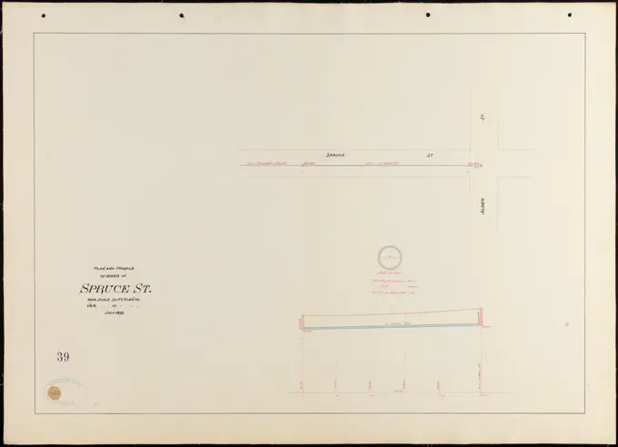
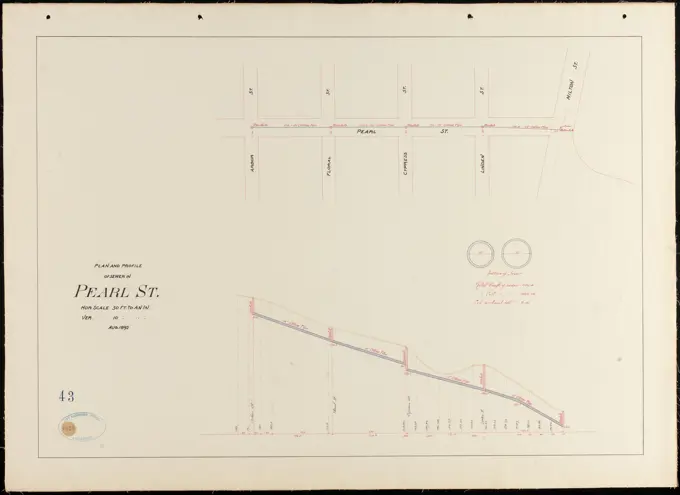
My Boards
View Pictures
  • My Boards

Architectural Plans & Profiles

Detailed plans and profiles of streets and buildings, featuring technical drawings in pencil and ink on paper, showcasing historical architecture and urban layouts.

Plan and profile of sewer in Spruce St. , Sewers, Streets. Lawrence
191 assets in this story
6145-48447547
Jansen Hermann (1869-1945), Planning for Plowdiw (03.07.1942): Road profiles 1: 100. Light break on paper, 50.3 x 75.5 cm (including scan edges) Jansen Hermann  (1869-1945): Planung für Plowdiw
6145-48502115
test111
6145-50511468
Plan of lots in Beech Grove Cemetery, Rockport ,
6145-48477731
Böhmer & Petrich, Stadium in Poznan (08.08.1940): floor plan 1: 200. Light break on the cardboard, 97.2 x 203.2 cm (including scan edges) Böhmer & Petrich : Stadion, Posen
6145-48461479
Klomp Johannes Franziskus (1865-1946), Benedectier Abbey St. Mauritius, Clerf (Clervaux), Luxembourg (November 10, 1908): Detailing the basement window of the monastery 1: 100. Ink, pencil on transparent, 61.7 x 102 cm (including scan edges) Klomp Johannes Franziskus  (1865-1946): Benedektinerabtei St. Mauritius, Clerf (Clervaux)
4443-19593257
Nisser Werk, James Heath, 1757-1834, British, after James Bruce, 1730-1794, British, 1789, Engraving
6145-48469705
Poelzig Hans (1869-1936), vocational schools on Urban, Berlin-Kreuzberg: Detailed Axis Scheme Runder component Hof page 1:10. Pencil on transparent, 99.50 x 151.00 cm (including scan edge).
6145-42621252
N.N., Schluse am Mühlendamm, Berlin: floor plan 1: 100. Lithograph on paper, 47.5 x 131.2 cm (including scan edges) N.N. : Schleuse am Mühlendamm, Berlin
6145-54523794
Cartographic, Maps. 1884 - 1936. Lionel Pincus and Princess Firyal Map Division. Fire insurance , New York (State), Real property , New York (State), Cities & towns , New York (State) Brooklyn V. 11, Plate No. 3 Map bounded by New York Bay, Shore Rd.
6145-48486647
N.N., Oder-Spree Canal. Conversion Frearche, Fürstenwalde/Spree (09.1890): Ice parts of the shooting army: views, floor plans, cuts, details 1:20. Lithograph on paper, 100.9 x 71.1 cm (including scan edges) N.N. : Oder-Spree-Kanal. Umbau Freiarche, Fürstenwalde/Spree
6145-46743200
Large copper mountain chronology. From Carl Sahlin's mountain historical collection.
6145-48478537
Klomp Johannes Franziskus (1865-1946), St. Antonius of Padua, Rheine: Detail of the cover plates, capitals and columns (various standards). Pencil, colored pencil on transparent, 100.7 x 151.6 cm (including scan edge). Architecture Museum of the Technical University of Berlin Inv. No. JK 019.117. Klomp Johannes Franziskus  (1865-1946): St. Antonius von Padua, Rheine
6145-51939981
Drawing..
6145-48483233
N.N., water levels in the Pregel valley from Isterburg to the Auxinne. (From: Atlas to the magazine for Building, ed. V. G. Erbkam, Jg. 38, 1888) (1888-1888): Graphics. Lithograph on paper, 45.7 x 59.9 cm (including scan edges) N.N. : Wasserstände im Pregeltal von Isterburg bis zum Auxinne. (Aus: Atlas zur Zeitschrift für Bauwesen, hrsg. v. G. Erbkam, Jg. 38, 1888)
6145-48469799
Poelzig Hans (1869-1936), vocational schools on Urban, Berlin-Kreuzberg: Detailed Axis Scheme Runder component Street side 1:10. Pencil on transparent, 95.50 x 141.00 cm (including scan edge).
6145-42606372
Götze H. A., settlement plan with a school house group. Schinkel competition 1931 (1931): Road profiles 1: 500. Ink, pencil on transparent, 61 x 75.6 cm (including scan edges) Götze H. A. : Siedlungsplan mit Schulhausgruppe. Schinkelwettbewerb 1931
6145-42608514
Poelzig Hans (1869-1936), vocational school on Urban, Berlin-Kreuzberg (February 27, 1929): Ausken excerpts, basement window scheme. Pencil on transparent, 37.6 x 71.9 cm (including scan edges)
6145-42630264
Orth August (1828-1901), art collection on the Museum Island, Berlin. Project II (1875): Grundriss eG. Photo on paper, 41.2 x 57.6 cm (including scan edges)
6145-48485223
Böhmer Franz (1907-1943), Poznan Castle, Poznan (1939-1943): Plan content N.N. detected. Material/technology N.N. Captured, 47.4 x 71.4 cm (including scan edges) Böhmer & Petrich : Schloss Posen, Posen. Umbau
6145-44024751
Gesim's, Profile
4443-73193788
Pronk, Cornelis, Emmerik, Haen, Abraham de (II), Toll house and side facade of the Munsterkerk in Emmerik, handwritten in pencil and brown pen, Sheet 68 recto from a sketchbook with 69 sheets., sketchbook sheet, drawings, Toll house, 28 July, Munsterkerk Emmerik, 1707-04-06 - 1748-08-08, draughtsman, draftsman, 1731-07-28 - 1731-07-28, second quarter 18th century, paper, ink, pencil, pen, North Netherlands, 1691-12-10 - 1759-09-29
6145-48479936
N.N., Green Week, Berlin-Charlottenburg (without date): View natural stone wall 1:50. Light break on paper, 25.2 x 42.3 cm (including scan edges) N.N. : Grüne Woche, Berlin
6145-50574059
Plan and profile of sewer in Clarke St. , Sewers, Streets. Lawrence
6145-54562260
El Kab. Temple of Amenhetep III. Inscription on architraves; Incriptions below Hathor masks on the fronts of the columns ...; Sculptures on the dado; Cornice of recess; Painting on the ceiling of the central alley. Tylor, J. J. (Joseph John), 1851-1901. Plans. 1898. General Research Division. Temples , Egypt, Elkab (Extinct city)
6145-42623154
Böhmer Franz (1907-1943), Poznan Castle, Poznan. Conversion (1939-1943): Plan content N.N. detected. Material/technology N.N. recorded, 62.7 x 90.3 cm (including scan edges) Böhmer & Petrich : Schloss Posen, Posen. Umbau
6145-48472418
Böhmer Franz (1907-1943), Park Hotel in Posen (April 19, 1940): Stuckprofiles in the restaurant 1: 1. Pencil, colored pencil on transparent, 84.8 x 90.6 cm (including scan edges)
6145-52376747
Elevation of Chimney Breast, showing arrangement of flue linings.. text. Illustrations, Advertisements, Catalogs. 1877 - 1893. Science, Industry and Business Library: General Collection. Plumbing , Equipment and supplies , Catalogs
6145-42612065
Klomp Johannes Franziskus (1865-1946), rectory in St. Bartholomäus, Schwagstorf (1903): Metal fittings of the main entrance door 1: 1. Pencil on transparent, 88 x 155.1 cm (including scan edges) Klomp Johannes Franziskus  (1865-1946): Pfarrhaus zu St. Bartholomäus, Schwagstorf
6145-52835030
Drawing of the wreath cornice and underground area of Palais Lützow at Bösendorferstraße 13 in Vienna I by Carl von Hasenauer, executed on wax screen with black, red, and blue spring, including watercolor, 27 July 1870.
6145-50537956
Dana Center Cemetery, Dana, Mass., July 1936 , waterworks, reservoirs water distribution structures, real estate, cemeteries
6145-54548713
Utica in 1802. Cartographic. Maps. 1850. Lionel Pincus and Princess Firyal Map Division. Utica (N.Y.) , Maps
6145-42626446
N.N., Bridges in the course of Duisburg - Ruhrorter Straße, Duisburg -Ruhrort: View, floor plan 1: 500. Lithograph on paper, 51.6 x 141.2 cm (including scan edges)
6145-42605574
Wentzel Emil, Brücke (1851): floor plan. Ink on cardboard, 80.2 x 168.5 cm (including scan edges) Wentzel Emil : Brücke
6145-48752097
324 acres adjoining Sudbury, granted ot Stephen Day, printer, 1657 (purchased by Goodman Johnson, 1668) , Land owners, Day, Stephen, 1594-1668. Wayland Historical Maps and Plans
6145-48438037
Erdmann & Spindler, development of the Kaiser-Wilhelm-Straße in Berlin (without date): 2 cross-sections 1: 150. Ink on cardboard, 72.5 x 100.7 cm (including scan edges) Erdmann & Spindler : Bebauung der Kaiser-Wilhelm-Straße, Berlin
6145-50511749
Plan of Tarbox Street in Lawrence and Methuen , Streets. Lawrence
6145-54548932
Paving map 4th Ave. from 37th to 40th Street. 1858. Cartographic. Maps, Manuscript maps. Lionel Pincus and Princess Firyal Map Division. Manhattan (New York, N.Y.),Maps, New York (N.Y.),Maps, City planning , New York (State) , New York , Maps
6145-44025014
Profile
6145-43759930
Hampshire St. between Oak St. and Essex St. , Streets. Lawrence
6145-42602957
Lüdecke Carl Johann Bogislaw (1826-1894), branch of the Prussian bank, Breslau (19.08.1874): front view: floor plans, cut for the base of the gripping, scale bar. Ink, ink colored, watercolor on cardboard, 60.4 x 144.1 cm (including scan edges) Lüdecke Carl Johann Bogislaw  (1826-1894): Filiale der Preußischen Bank, Breslau
6145-52833752
Pencil sketch by Carl von Hasenauer of Hermesvilla in Vienna XIII, illustrating architectural features and spatial arrangement on paper.
6145-42605215
EBE & BENDA, redesign of the castle freedom in Berlin. Monthly competition September 1874 (09.1874): floor plan. Photo paper on cardboard, 26.6 x 39 cm (including scan edges) Ebe & Benda : Umgestaltung der Schlossfreiheit, Berlin. Monatskonkurrenz September 1874
4443-22034198
French textile manuscript, ca. 1820, ca. 1820, an instruction manual for a school associated with a manufactory begins with a history of silk manufacture and continues with discussion of contemporary silk makers in Spain, Italy and France. The text is illustrated with 136 intricate drawings of looms, many in watercolor, showing set-ups for various patterns and materials, and includes 102 tipped-in examples of fabric. The chapters contain detailed information on silkworms and their breeding, the pulling of silk, and the composition of fashion materials, including gauze and damask.
6145-59297526
Sailing ship and a sail, 1890 - 1946  Page 28 Recto from a sketchbook with 73 sheets.  paper. pencil  sailing-ship, sailing-boat. sail
6145-43759707
Profile of part of Broadway made for the City of Lawrence , Streets. Lawrence
6145-54534630
Thèbes, Médinet-Habou Thebes, Medinet Habu. Palais de Rhamsès IV, seconde cour, galerie de l'est, paroi à gauche de la porte. Scène de la grande panégyrie célébrée en l'honneur du dieu Sochar-Osiris par le roi Rhamsès-Méïamoun, .... Champollion, Jean-François, 1790-1832. Prints, Illustrations. 1845. General Research Division. Egypt , Antiquities
6145-54566034
Alexandrie. Autre obélisque. (Première et seconde face). Champollion, Jean-François, 1790-1832. Prints, Illustrations. 1845. General Research Division. Egypt , Antiquities
6145-30334382
Sir Robert Smirke the younger, 1781-1867, British, Capital of the Columns of the Temple of Minerva, 1802-1804. Graphite, pen and brown ink on thin, moderately textured, beige, laid paper.
6145-54548139
Sketches showing grades and distances of streets 1780 - 1810. Cartographic. Maps, Surveys, land surveys. Manuscripts and Archives Division
6145-50574205
Plan and profile of sewer in Pearl St. , Sewers, Streets. Lawrence
6145-42603474
Jansen Hermann (1869-1945), total development plan Ankara (1928-1928): Environment to the universities: length processing 1: 2000, heights 1: 1000. Ink on transparent, 35.1 x 129.4 cm (including scan edges) Jansen Hermann  (1869-1945): Gesamtbebauungsplan Ankara
6145-42611991
Klomp Johannes Franziskus (1865-1946), Franciscan monastery and Heilig Kreuz, Essen (September 30, 1903): Scripture for the exam door and cross of the doorstep 1: 1. Pencil on transparent, 54.6 x 105.6 cm (including scan edges) Klomp Johannes Franziskus  (1865-1946): Franziskanerkloster und Heilig Kreuz, Essen
6145-42608704
Klomp Johannes Franziskus (1865-1946), Trinity Church (with rectory), Dortmund (May 29, 1900): Sketch to anchor altarbalachin. Ink, pencil on transparent, 25.3 x 46.3 cm (including scan edges)
6145-29916499
Project for the Bridge of Neuilly.
6145-42606338
Unknown architect, grave monument for Privy Councilor Koch in Thale. Monthly competition November 1877 (11.1877): floor plan; Scale bar, explanatory text. Pencil watercolored on paper, 32.8 x 40.5 cm (including scan edges) N.N. : Grabdenkmal für Geheimrat Koch, Thale. Monatskonkurrenz November 1877
6145-55924445
Cartographic, Maps. 1889. Lionel Pincus and Princess Firyal Map Division. Real property , New York (State) , New York, New York (N.Y.) Plate 41 Map bounded by W. 102nd St., W. 98th St., Riverside Park, W. 94th St., Hudson River
6145-50523441
Andover Street, Lawrence, 1965 , Streets, Boundaries. Lawrence
6145-59600732
Early map of the archipelago of the East Indies, Desiré Heyse, 1846 print Early map of various mountains in the East Indies area. At the bottom right four scale sticks.  paper  mountain-top, peak East-India
6145-29916735
Plan of the carpentry of the carme market
6145-50572378
Plan of a town way in Rockport, Mass., from Main to High Street as laid out by the county commissioners , Streets
6145-42607718
Messel Alfred (1853-1909), Landhaus Dr. Franz Oppenheim, Berlin-Wannsee (September 12, 1907), fence, 1:10, pencil on paper, TU UB Plan collection inv. No. 13239
6145-42611551
Böhmer Franz (1907-1943), official apartment of the Reich Foreign Minister Joachim von Ribbentrop in Berlin-Mitte (1941-1941): Terrace wall to the garden 1:20. Light break on transparent, 28.7 x 94.1 cm (including scan edges) Böhmer & Petrich : Dienstwohnung des Reichsaußenministers Joachim von Ribbentrop, Berlin-Mitte. Umbau
6145-42606599
Unknown architect, wooden viaduct. Monthly competition January 1879 (01.1879): floor plan, longitudinal section 1: 250; Scale bar. Tusche watercolor on the box, 44.3 x 66.4 cm (including scan edges) N.N. : Hölzerner Viadukt. Monatskonkurrenz Januar 1879
6145-42603790
Boumann Johann (1706-1776), Potsdam town houses. Building recordings (so-called Ziller-Folder) around 1850. Breite Straße 35 (year of construction 1749) (September 15, 1859): Riss front view facade (scale bar, foot). Pencil and ink watercolor on paper, 33.6 x 45.9 cm (including scan edges) Boumann d. Ä. Johann  (1706-1776): Potsdamer Bürgerhäuser. Bauaufnahmen (sog. Ziller-Mappe) um 1850. Breite Straße 35 (Baujahr 1749)
6145-48718525
A plat showing the position of the different townships , Hocking County Ohio, Maps, Manuscript Norman B. Leventhal Map Center Collection
6145-48732687
Plan of land from estate of Maria L. Phillips to Town of Rockport at Pigeon Cove, Mass. ,
6145-59502173
The camp in Oirschot in 1832, G.M. Heaton, 1832  Map of the Dutch Army Camp in Oirschot, tents uprising. Right part of a representation of 2 or 3 stones (an intervening part is missing). print maker: Netherlandsafter design by: Netherlandsprinter: Amsterdam paper  (military) camp with tents Oirschot
6145-48451752
Seeling Heinrich (1852-1932), Place design in front of the Brandenburg Gate in Berlin. Monthly competition January 1876 (01.1876): Templation template with drawings (site plan); Explanation text. Ink over pressure on cardboard, 32.9 x 48.6 cm (including scan edges) Seeling Heinrich  (1852-1932): Platzgestaltung vor dem Brandenburger Tor, Berlin. Monatskonkurrenz Januar 1876
6145-30306672
Fundriß and cross -section through a Donauenge near Bezdány Hungary,
6145-46750532
Big Kopparberg's mountain team. From Carl Sahlin's mountain historical collection.
6145-55928402
Cartographic, Maps. 1907. Lionel Pincus and Princess Firyal Map Division. Fire insurance , New York (State), Real property , New York (State), Cities & towns , New York (State) Manhattan, V. 6, Plate No. 75 Map bounded by Hudson River
6145-46742388
Large copper mountain chronology. Mining maps.ur Carl Sahlin's mountain historical collection.
6145-42603501
Unknown architect, palace (approx. 1820): longitudinal section. Pencil and ink on paper, 15.5 x 88.9 cm (including scan edges) N.N. : Palast
6145-42608032
Klomp Johannes Franziskus (1865-1946), St. Anna, Lenhausen (November 12, 1898): View of the roof rider 1:20. Ink on transparent, 77.2 x 28 cm (including scan edges)
6145-48491650
N.N., Elimination of the rail crossing of the Breitenweg, Magdeburg-Neustadt. (From: Atlas to the magazine for Building, ed. V. Ministry of Public Work, Jg. 52, 1902): Plans before and after the conversion, I. and II. Construction phase. Hint colored on paper, 59.6 x 44.2 cm (including scan edges)
6145-48528813
Ogrodzieniec. Rzuty i detale więzienia skalnego zamkowego z rys. Maryana Wawrzenieckiego z 1883 roku w zbiorach Towarzystwa Opieki na Zabytkami Przeszłości - rzut jaskini, wejście i drzwi. Gembarzewski, Bronisław (1872-1941), draughtsman, cartoonist
6145-53197003
Drawing on Boggie freight wagon for track width 600, scale: 1: 40 from the limited company Södertälje workshops.
6145-59081715
Ogrodzieniec. Castle -wing -wing -ranges and details of the drawing of Maryan Wawrzeniecki from 1883 in the collections of the Society for Care at the monuments of the past - a projection of a cave, entrance and door; Gembarzewski, Bronis AW (1872-1941); 1915 (before February 22, 1915) (1915-00-00-1915-00-00);
6145-48665690
Indian Orchard , Springfield Mass., Maps, Railroads, Massachusetts, Springfield, Maps Norman B. Leventhal Map Center Collection
6145-42619677
Böhmer Franz (1907-1943), Poznan Castle, Poznan (1939-1943): Plan content N.N. detected. Material/technology N.N. Captured, 28.2 x 46.8 cm (including scan edges) Böhmer & Petrich : Schloss Posen, Posen. Umbau
6145-51396265
Map of Connecticut River from Barnet Vermont to Hartford Con : by actual survey in 1825 , Connecticut River, Maps, Manuscript Norman B. Leventhal Map Center Collection
6145-42606651
Pinkenburg Georg (1849-1906), connecting station. Monthly competition December 1879 (12.1879): Department 1: 1000; Average profile. Tusche watercolor on the box, 49.6 x 134.7 cm (including scan edges) Pinkenburg Georg  (1849-1906): Anschlussbahnhof. Monatskonkurrenz Dezember 1879
6145-43861028
Map of the Monongahela River from Pittsburgh to Brownsville showing the location of coal works , Coal mines and mining, Monongahela River W. Va. and Pa., Maps, Monongahela River W. Va. and Pa., Maps Norman B. Leventhal Map Center Collection
6145-55956589
An improved map of the Hudson River : with the post roads between N. York & Albany Cartographic. Maps. 1834. Lionel Pincus and Princess Firyal Map Division. New York (N.Y.), New Jersey, Hudson River (N.Y. and N.J.) , Maps, Tourist, Hudson River Valley (N.Y. and N.J.) , Maps, Tourist
6145-54267663
Indian Orchard. From the Station grounds plat book of Worcester, MA and west.... , Massachusetts  , Hampden  ,county   , Springfield
6145-51939901
Drawing..
6145-42610257
Böhmer Franz (1907-1943), Reich Ministry of Food and Agriculture in Berlin-Mitte (November 7, 1941): Ceiling profile in the upper staircase 1: 1. Pencil, coal on transparent, 50.6 x 86.6 cm (including scan edges)
6145-54268218
A new map of the Hudson River : the post roads between N. York & Albany, the northern and western canals, &c., &c. Shows the Hudson River from Glenville to New York City. Relief shown by hachures and spot heights. Covers, list of distances, and advertisements pasted into a booklet.... , Hudson River New York
6145-48469736
Brix & Genzmer, Groß -Berlin 1910 competition. Circummeration Dahlem, Lichterfelde (1908-1910): Example of a conversion: Zehlendorf - Dahlem - Lichterfelde, laying after streets 1: 10000. Tusche watercolor on paper, 95.6 x 58.9 cm (including scan edges)
6145-29623425
Collection of the Dutch Heidematschappij. High extraction / low extraction. undated
6145-42605887
Gerlach Friedrich (1856-1938), port and channel facility in Berlin-Gesundbrunnen (north Canal). Schinkel competition 1886 (June 18, 1886): Length profile 1: 4000, 1: 100. Ink, ink colored, watercolor on cardboard, 49.3 x 195.8 cm (including scan edges) Gerlach Friedrich  (1856-1938): Hafen- und Kanalanlage, Berlin-Gesundbrunnen (Nordkanal). Schinkelwettbewerb 1886
PREVIOUS
of 2
NEXT
2401 S. Ervay, Suite 206
Dallas, Texas 75215
United States
Get Started
Free ResearchMy BoardsMy Cart
For Creators
How To License Your ContentContributor PortalFrame of Mind
Resources
API accessPricing
Contact
+1 866 236 0087help@viewpictures.co.uk Contact form
©2026 View Pictures. All Rights Reserved. -A
This site is protected by reCAPTCHA and Google Privacy Policy and Terms of Service apply.