My Boards
View Pictures
  • My Boards
← Documents & Records

Boston Historical Maps

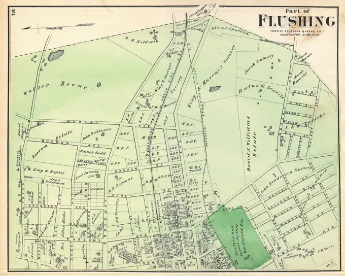
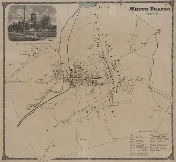
Detailed vintage maps of Boston and West Roxbury, showcasing real property and landowners. The style is classic, preserving historical significance and geographical information.

Bergen County, V. 2, Double Page Plate No. 26 Map bounded by Borough of Midland Park Cartographic. Atlases, Maps. 1912 - 1913. Lionel Pincus and Princess Firyal Map Division. Bergen County (N.J.)
366 assets in this story
6145-48621281
Wakefield, Massachusetts ,. Lucius Beebe Memorial Library Historic Maps
6145-55957621
Part of Town of Southampton Cartographic. Atlases, Maps. 1915 - 1917. Lionel Pincus and Princess Firyal Map Division. Suffolk County (N.Y.)
6145-55175987
E.B. Hyde & Co.. Cartographic, Maps. 1907. Lionel Pincus and Princess Firyal Map Division. Brooklyn (New York, N.Y.) , Maps, Real property , New York (State) , New York Brooklyn, Vol. 7, Double Page Plate No. 43; Part of Ward 31, Section 22; Map bounded by Shell Bank Creek, Hog Point Creek; Including Sheepshead Bay, Ford St., Avenue Y; Sub Plan; Map bounded by Cerritsens Creek, Sheepshead Bay, Broad Creek, Voorhies Ave., Avenue Z; Including Avenue Y, Avenue X, Bragg Ave., Avenue W, Gerritsen Ave.
4409-21510763
Plate 36: Bounded by Horton Street, Third Boston Road, Briston Street, ....Bronx River, Dickey Street, Hunt's Point Road, Southern Boulevard, ...... Clifton Street and Third Avenue.
4443-11173
MAP OF NEVERS, FRANCE
6145-48719750
The Rand-McNally map of the city of Havana showing suburbs, parks, forts, and principal buildings , Streets, Cuba, Havana, Maps, Buildings, Cuba, Havana, Maps, Railroads, Cuba, Havana, Maps, Spanish-American War, 1898, Cuba, Havana, Maps, Havana Cuba, Maps Norman B. Leventhal Map Center Collection
6145-50570254
Atlas of the county of Suffolk, Massachusetts : vol. 1st including Boston proper : from actual surveys and official records : plate Z , Real property, Massachusetts, Boston, Maps, Landowners, Massachusetts, Boston, Maps, Boston Mass., Maps Norman B. Leventhal Map Center Collection
6145-51391178
Atlas of the county of Suffolk, Massachusetts : vol. 4th including East Boston, city of Chelsea, Revere and Winthrop : from actual survey official records & private plans : plate P , Real property, Massachusetts, Revere, Maps, Landowners, Massachusetts, Revere, Maps, Revere Mass., Maps Norman B. Leventhal Map Center Collection
4443-75459143
Index, 1882, G.M. Hopkins & Co., Philadelphia, Publisher, The Company, Auburn (N.Y.)
6145-59588347
Map of the Zijpepolder, Anonymous, Jan Dirksz. Zoutman, in or after 1664 print At the top left a bowl: 500 Hontsboscher rods. At the bottom of the title cartouche. At the top right the weapon of the polder.  paper engraving maps of separate countries or regions. polder, reclaimed land Zijpe and Hazepolder
6145-54549849
Islip Cartographic. Atlases, Maps. 1915 - 1917. Lionel Pincus and Princess Firyal Map Division. Suffolk County (N.Y.)
6145-55958876
Upper Nyack Cartographic. Maps, Cadastral maps. 1890. Lionel Pincus and Princess Firyal Map Division. Landowners , New York (State) , Upper Nyack, Real property , New York (State) , Upper Nyack, Upper Nyack (N.Y.)
6145-55926815
Cartographic, Maps. 1874. Lionel Pincus and Princess Firyal Map Division. Staten Island (New York, N.Y.) Part of Southfield & Middletown Section 21
6145-29929659
Little Montrouge district and municipality of Montrouge / Sheet324 / 1956
6145-50570788
Atlas of the county of Suffolk, Massachusetts : vol. 4th including East Boston, city of Chelsea, Revere and Winthrop : from actual survey official records & private plans : plate H , Real property, Massachusetts, Chelsea, Maps, Landowners, Massachusetts, Chelsea, Maps, Chelsea Mass., Maps Norman B. Leventhal Map Center Collection
6145-55167626
The Rand-McNally map of the city of Havana showing suburbs, parks, forts, and principal buildings. Date of publication taken from date of acquisition. Relief shown by hachures. Shows site of the wreck of the USS Maine in Havana Harbor in 1898; street names, select buildings, military facilities and fortifications, railroads, "electric roads," ferries, cemeteries, and points of interest. Includes directory... Map of the city of Havana Rand McNally pocket map of Havana. Map of the city of Havana Rand McNally pocket map of Havana, Cuba  , Havana  ,province   , Havana
6145-55917438
The town of Boston in New England. Oriented with north toward the upper right. Index: A-M. a-h. "Aetatis suae 80" under author's name. "Engraven and printed by Fra. Dewing. Boston N.E. 1722 Sold by Capt. John Bonner and Willm. Price against ye Town House where may be had all sorts of prints, mapps &c." Boston Public Library copy is an original, previously unrecorded state. Christ Church, fig. "M," is a unique addition to the index. Date of map is between 1723 and 1733.. Made in Boston: Bonner's map depicts Boston before centuries of landfill transformed its coastline. His distinctive design combines plan and perspective views to convey maximum information and achieve decorative effect. It shows clearly the patterns of settlement, dense in the North End and along Cornhill and King Streets but thinning toward the south and west. The abundance of wharves, shipyards and ropewalks reflects Boston's flourishing maritime economy. Captain Bonner was more comfortable drawing sailing vessels tha
6145-50570276
Atlas of the county of Suffolk, Massachusetts : vol. 3rd including Boston and Dorchester : from actual surveys and official records : plate D , Real property, Massachusetts, Boston, Maps, Landowners, Massachusetts, Boston, Maps, South Boston Boston, Mass., Maps Norman B. Leventhal Map Center Collection
6145-52359850
Portion of Long Branch Village Cartographic. Atlases, Maps. 1873. Lionel Pincus and Princess Firyal Map Division. Monmouth Couty (N.J.) , Description and travel, Real property , New Jersey , Monmouth County
6145-55958895
Williams' map of the City of Binghamton, N.Y.: revised and corrected from actual surveys and official records for Williams' city directory Map of the City of Binghamton, N.Y. Cartographic. Maps, Cadastral maps. 1899. Lionel Pincus and Princess Firyal Map Division. Real property , New York (State) , Binghamton, Binghamton (N.Y.), Broome County (N.Y.)
6145-48718533
Plan of house lots in Natick belonging to Eben. Whitney : together with a part of Natick Village , Housing development, Massachusetts, Natick, Natick Mass., Maps, Whitney, Eben Norman B. Leventhal Map Center Collection
6145-55181334
Otego Village; Otsdawa Village; Otego Business Directory. ; Worcester Village; Worcester Business Directory. Cartographic. Atlases, Maps. 1868. Lionel Pincus and Princess Firyal Map Division. Otsego County (N.Y.), Real property , New York (State) , Otsego County
6145-54549844
Part of Babylon Cartographic. Atlases, Maps. 1915 - 1917. Lionel Pincus and Princess Firyal Map Division. Suffolk County (N.Y.)
4409-21509802
Part of New Brighton.
6145-55958571
Morris County, Double Page Plate No. 18 Map bounded by Mill Rd., Speedwell Ave., Grant St., Early St., Lake Valley Rd. 1910. Cartographic. Atlases, Maps. Lionel Pincus and Princess Firyal Map Division. Morris County (N.J.)
6145-29095591
1873 Beers Map of Part of Flushing, Queens, New York City
6145-55959471
Map of the City of Utica, Oneida Co., N.Y.: from original surveys and records Cartographic. Maps, Cadastral maps. 1868. Lionel Pincus and Princess Firyal Map Division. Landowners , New York (State) , Utica, Real property , New York (State) , Utica, Utica (N.Y.), Utica (N.Y.) , Administrative and political divisions
6145-55958286
Newark, V. 2, Double Page Plate No. 56 Map bounded by Newark Bay, Clifford St., Avenue I Cartographic. Atlases, Maps. 1911-12. Lionel Pincus and Princess Firyal Map Division. Newark (N.J.)
6145-55958283
Newark, V. 2, Double Page Plate No. 50 Map bounded by Thomas St., Avenue L, Alpine St., Avenue E, Avenue D Cartographic. Atlases, Maps. 1911-12. Lionel Pincus and Princess Firyal Map Division. Newark (N.J.)
6145-55181286
Olcott Village; Business Notices Town of Porter; Porter Township Cartographic. Atlases, Maps. 1875. Lionel Pincus and Princess Firyal Map Division. Niagara County (N.Y.), Orleans County (N.Y.), Real property , New York (State) , Niagara County, Real property , New York (State) , Orleans County
4443-75465394
Map of the Cities of Albany and Rensselaer and portions of Bath and East Greenbush, New York, 1899. Issued by Sampson, Murdock & Co., 448 Broadway, Albany, N.Y., 1 map; 64 x 58 cm
6145-54549890
Part of Brookhaven and Riverhead Suffolk County; Yaphank Cartographic. Atlases, Maps. 1915 - 1917. Lionel Pincus and Princess Firyal Map Division. Suffolk County (N.Y.)
6145-29096800
1850 Tallis Map of West Canada or Ontario (cropped - Eastern Ontario)
6145-48644498
The city of Lawrence, Mass : south side ,. Lawrence Public Library Map Collection
6145-55181601
Monmouth County, Double Page Plate No. 18 Map Bounded by Manasquan Turnpike, 12th Ave., Atlantic Ocean, Jersey Ave. 1889. Breou, Forsey. Cartographic. Atlases, Maps, Surveys, Plans. Lionel Pincus and Princess Firyal Map Division. Monmouth County (N.J.)
6145-54550008
Suffolk County, V. 2, Double Page Plate No. 27 Map bounded by Mattituck, Orient, New Suffolk Cartographic. Atlases, Maps. 1902 - 1909. Lionel Pincus and Princess Firyal Map Division. Suffolk County (N.Y.)
6145-48719517
Atlas of the city of Cambridge, Middlesex Co., Massachusetts. plate C , Real property, Massachusetts, Cambridge, Maps, Landowners, Massachusetts, Cambridge, Maps, Cambridge Mass., Maps Norman B. Leventhal Map Center Collection
6145-50511810
Plan of the Highlands, the property of the Vineyard Grove Co : Cottage City, Mass , Real property, Massachusetts, Oak Bluffs, Maps, Cottage City Mass., Maps, Oak Bluffs Mass., Maps Norman B. Leventhal Map Center Collection
4443-73241041
Utrecht, Houtman, Johannes Paulus, Plan of Bergen op Zoom, Map of Bergen op Zoom after the explosion of Stoelemat, 1831, verso - stamped, Map of Bergen op Zoom indicating the damage caused by the explosion in the gunpowder magazine of the Stoelemat laboratory in Bergen op Zoom, 29 March 1831. Parts of the map indicated in colours. With the legend 1-63, AZ and AA-DD in four columns., print, map, prints, Frederik Muller Historieplaten, height 383 mm, width 262 mm, Dutch, 1803-05-01 - 1841, printer, 1831 - 1831, paper, lithography (technique), hand colouring
6145-50661197
Crossed below the year 1570.
6145-54549889
Part of Brookhaven Suffolk County Cartographic. Atlases, Maps. 1915 - 1917. Lionel Pincus and Princess Firyal Map Division. Suffolk County (N.Y.)
6145-55958321
Essex County, V. 3, Double Page Plate No. 10 Map bounded by Town of Nutley, Passaic River, Terry St., Division Ave., Hauck St. A.H. Mueller (Publisher). Cartographic. Atlases, Maps. 1906. Lionel Pincus and Princess Firyal Map Division. Essex County (N.J.), Newark (N.J.)
4409-21520586
Plate 16: Unionport - Westchester - Schuyerville :Town & County of Westchester, N.Y.
6145-51395170
Map of the town of Wakefield Middlesex Co. Mass : from actual surveys , Real property, Massachusetts, Wakefield, Maps, Landowners, Massachusetts, Wakefield, Maps, Wakefield Mass., Maps Norman B. Leventhal Map Center Collection
6145-52359635
Plate 71: White Plains, Westchester Co. N.Y. Cartographic. Atlases, Maps. 1872. Lionel Pincus and Princess Firyal Map Division. Westchester County (N.Y.), Real property , New York (State) , Westchester County
6145-46580595
. Map of Zijpe and surroundings. At the top of the coat of arms of Zijpe. At the bottom of a cartouche with a legend. Bottom left a scale.
6145-55181574
Morris County, Double Page Plate No. 8 Map bounded by Passaic River, Ridgedale Ave., S. Orange Ave., Park St. 1910. Cartographic. Atlases, Maps. Lionel Pincus and Princess Firyal Map Division. Morris County (N.J.)
6145-55181578
Morris County, Double Page Plate No. 13 Map bounded by Whippany River, South St., Ford Ave., Morris Ave. 1910. Cartographic. Atlases, Maps. Lionel Pincus and Princess Firyal Map Division. Morris County (N.J.)
6145-51391343
Atlas of the towns of Revere and Winthrop, Suffolk County, Massachusetts. sheet 18 , Real property, Massachusetts, Revere, Maps, Landowners, Massachusetts, Revere, Maps, Revere Mass., Maps Norman B. Leventhal Map Center Collection
4443-75466526
A map of White Plains, Westchester County, New York, issued in 1868 by F.W. Beers. The map is in color and measures 57 x 60 cm, printed on a sheet that measures 59 x 64 cm. It includes details on courthouses, real property, and landowners in the area
6145-51395218
Map of the village of Claremont, New Hampshire , Landowners, New Hampshire, Claremont, Maps, Real property, New Hampshire, Claremont, Maps, Claremont N.H., Maps Norman B. Leventhal Map Center Collection
6145-48446767
Jansen Hermann (1869-1945), Building Plan Kleinsiedlung Norden, Rathenow (01.04.1921): Grund- und D move plan 1: 2500, (by Inv. No. 21092). Light break on the cardboard, 65.5 x 51.6 cm (including scan edges) Jansen Hermann  (1869-1945): Bebauungsplan Kleinsiedlung Norden, Rathenow
6145-50552627
Map of Cambridge , Cambridge Mass., Maps Norman B. Leventhal Map Center Collection
6145-55181165
Addison Business Notices; Addison Village Cartographic. Atlases, Maps. 1873. Lionel Pincus and Princess Firyal Map Division. Steuben County (N.Y.), Real property , New York (State) , Steuben County, Business enterprises , New York (State) , Steuben County
6145-43818354
Plan of Newburyport made by Philander Anderson, dated May 1830 ,. Massachusetts. Office of the Secretary of State
4409-21520053
Part of the Village of Far Rockaway.
6145-55916279
Plan of Groton Cemetery. Oriented with north toward the upper left. Shows plot numbers, paths, and avenues. Includes name index of proprietors of lots, note, and 3 views: Plan for a temple to be located on the circular area in sect. 16, Fence for the north & south lines, and Plan of the front entrance.... , Massachusetts  , Middlesex  ,county   , Groton
4409-21511875
Part of Westfield.
6145-48718792
Contour plan, Melbourne and suburbs , Melbourne Vic., Maps, Topographic maps Norman B. Leventhal Map Center Collection
6145-50550347
Lake Park, Athol, Mass , Real property, Massachusetts, Athol, Maps, Athol Mass., Maps Norman B. Leventhal Map Center Collection
6145-54549963
Walden Village Cartographic. Atlases, Maps. 1875. Lionel Pincus and Princess Firyal Map Division. Orange County (N.Y.), Real property , New York (State) , Orange County, Orange County (N.Y.) , History, Business enterprises , New York (State) , Orange County
6145-48719578
Atlas of the towns of Revere and Winthrop, Suffolk County, Massachusetts. sheet 24 , Real property, Massachusetts, Winthrop, Maps, Landowners, Massachusetts, Winthrop, Maps, Winthrop Mass., Maps Norman B. Leventhal Map Center Collection
6145-54549093
Williamsville Village; Williamsville Business Directory. Cartographic. Atlases, Maps. 1866. Lionel Pincus and Princess Firyal Map Division. Erie County (N.Y.)
6145-55181527
Cayuga County, Right Page Village of Meridian Cartographic. Atlases, Maps. 1904. Lionel Pincus and Princess Firyal Map Division. Real property , New York (State) , Herkimer County, Herkimer County (N.Y.) , Description and travel
6145-54548916
Fort Washington section. New York (N.Y.). Commissioners for Laying out Washington Heights. Cartographic. Maps. 1860. Lionel Pincus and Princess Firyal Map Division. Landowners , New York (State) , New York, Real property , New York (State) , New York, Washington Heights (New York, N.Y.)
6145-55958036
Cayuga County, Left Page Map of Montezuma Cartographic. Atlases, Maps. 1904. Lionel Pincus and Princess Firyal Map Division. Real property , New York (State) , Herkimer County, Herkimer County (N.Y.) , Description and travel
PREVIOUS
of 4
NEXT
2401 S. Ervay, Suite 206
Dallas, Texas 75215
United States
Get Started
Free ResearchMy BoardsMy Cart
For Creators
How To License Your ContentContributor PortalFrame of Mind
Resources
API accessPricing
Contact
+1 866 236 0087help@viewpictures.co.uk Contact form
©2026 View Pictures. All Rights Reserved. -A
This site is protected by reCAPTCHA and Google Privacy Policy and Terms of Service apply.