My Boards
View Pictures
  • My Boards
← Environment / Sustainability

BP Oil Spill Aerial Views

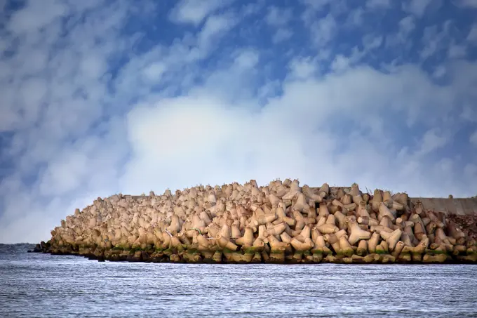
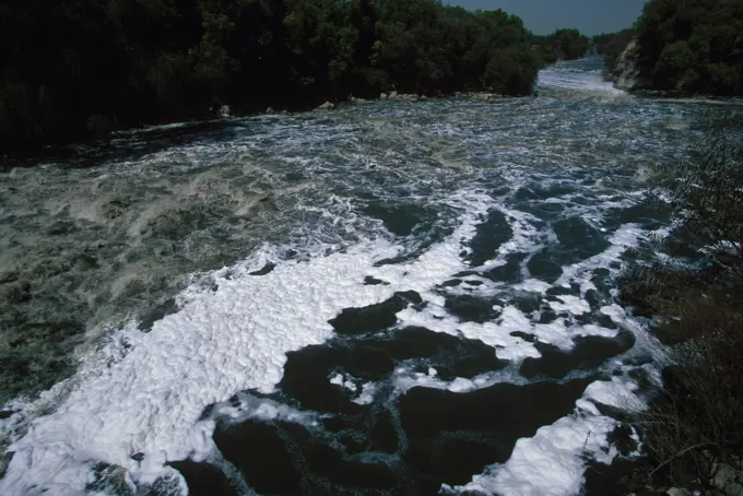
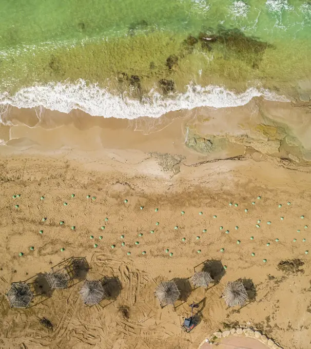
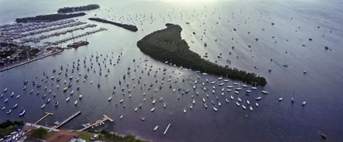
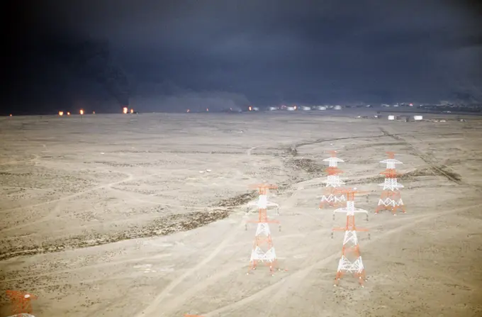
Aerial photographs depicting the aftermath of the BP Oil Spill, featuring oil slicks on water and distant oil platforms, reflecting environmental impacts.

Office of the Administrator (Lisa P. Jackson) - ASPECT Flight over Gulfport, Mississippi (BP Oil Spill) - USEPA photo by Eric Vance , Environmental Protection Agency
175 assets in this story
4220-20107798
Oil pollution in Sydney Harbour from a Tawinese vessel cleaning its bilges inside the heads. It took a week to clean up properly. Sydney harbour, Australia.
6145-52066340
ESU St. Louis - Unwatering - 26-HK-326-1. Hurricane Katrina
6188-54823620
breakwater around sea port is made of concrete tetrapods The seawall around the sea port facilities is made of concrete tetrapods traveling-wave protection, rubble-mound breakwater Copyright: xZoonar.com/MaximilianxBuzunx 15436900
6145-52066554
Pollution - ESU St. Louis Response - Miscellaneous - 26-HK-254-53. Overflight. Hurricane Katrina
6145-52029184
Office of the Administrator (Lisa P. Jackson) - ASPECT Flight over Gulfport, Mississippi (BP Oil Spill) - USEPA photo by Eric Vance , Environmental Protection Agency
6145-44627454
ISS010E12929 (13 January 2005) --- One of a series of post-tsunami digital still images which were photographed from the International Space Station on January 13, 2005. This image is centered at 14.41 degrees north latitude and 80.15 degrees east longitude and is located just south of Chennai (Madras) India. Scientists studying the ISS imagery have discerned a slight discoloration in coastal vegetation, likely caused by the December 2004 tsunami.
6145-44548185
STS078-736-064 (20 June - 7 July 1996) --- As photographed by the flight crew of the Space Shuttle Columbia in Earth-orbit, the city of Colorado Springs, Colorado, is seen near the eastern base of Pikes Peak.  It was built on a mesa at 6,008 feet (1,831 meters) sea level.  Pikes Peak is the large tan patch on the bottom left or west portion of the photo.  The city is the headquarters of Pike National Forest, located on its west side.  Founded in 1871 as Fountain Colony by General William J. Palmer, builder of the Denver and Rio Grande Western Railroad, it was renamed for the nearby Manitou mineral springs.  Growth of the area followed the Cripple Creek gold strikes in the 1890s and the promotion of the tourist-health-resort trade in the area.  The establishment of military installations gave further impetus to development.  The North American Air Defense and Aerospace Defense commands are headquartered at Peterson Air Force Base (Peterson Field).  Fort Carson (1942), on the city's sout
1525-22738606
water diversion dam on the South Platte River and a bike trail in northern Colorado, aerial view
6145-52029176
Office of the Administrator (Lisa P. Jackson) - ASPECT Flight over Gulfport, Mississippi (BP Oil Spill) - Oil from BP Oil spill in the Gulf of Mexico. USEPA photo by Eric Vance , Environmental Protection Agency
6145-54338448
Office of the Administrator (Lisa P. Jackson) - ASPECT Flight over Gulfport, Mississippi (BP Oil Spill) - Relief well drilling platform Gulf of Mexico. USEPA photo by Eric Vance , Environmental Protection Agency
6145-52029201
Office of the Administrator (Lisa P. Jackson) - BP Oil Spill (Web Photographs) - USEPA photo by Eric Vance , Environmental Protection Agency
6145-52029457
Office of the Administrator (Lisa P. Jackson) - ASPECT Flight over Gulfport, Mississippi (BP Oil Spill) - USEPA photo by Eric Vance , Environmental Protection Agency
6145-52029204
Office of the Administrator (Lisa P. Jackson) - ASPECT Flight over Gulfport, Mississippi (BP Oil Spill) - USEPA photo by Eric Vance , Environmental Protection Agency
6145-52030595
Office of the Administrator (Lisa P. Jackson) - BP Oil Spill (Web Photographs) - Lafourche, LA , Environmental Protection Agency
6145-52029463
Office of the Administrator (Lisa P. Jackson) - ASPECT Flight over Gulfport, Mississippi (BP Oil Spill) - USEPA photo by Eric Vance , Environmental Protection Agency
6145-54405657
Dolphin Rescue - 26-HK-130-428. Hurricane Katrina
6145-44710286
ISS017-E-010303 (4 July 2008) --- The Basin fire in central California is featured in this image photographed by astronaut Greg Chamitoff, Expedition 17 flight engineer, on the International Space Station. One of the largest and most destructive fires raging across California over the July 4 weekend was the Basin fire, threatening Big Sur, and covering the coast in a thick blanket of smoke. Chamitoff, observing the fires from approximately 344 kilometers above Earth (215 miles), was able to capture the regional view of the smoke pall. At the time this image was taken, more than 300 fires were burning in California alone. This Basin fire was triggered by a thunderstorm, has burned 77,000 acres, and is still only partially contained.
5514-65780126
Grand drainage canal which takes wastewater from Mexico City. The water is used for agriculture.
1848-49397478
In Black Sea Blue-green algae blooms, water in Odessa has become freshwater and green color. Environmental disaster caused by explosion of Kakhovka Hydroelectric Power Plant dam, Ukraine, Europe
1525-20755167
The Nazca Lines - Unesco world heritage site
4055-5532
Plastic trash in Los Angeles River, Bell, Los Angeles, California, USA
6145-54338446
Office of the Administrator (Lisa P. Jackson) - ASPECT Flight over Gulfport, Mississippi (BP Oil Spill) - Relief well drilling platform Gulf of Mexico. USEPA photo by Eric Vance , Environmental Protection Agency
6188-55641154
Ocean trash plastic cup at the bottom of the sandy ocean Copyright: xZoonar.com/YannxPoirierx 6135467
6145-50610604
New Jersey - Barnegat. Same as No. 11, from lantern gallery.
6145-54402409
Aftermath - Aerial - 26-HK-296-181. Hurricane Katrina
6162-49135766
Aerial view of Betset beach from top with plastic bag on the sand after clean up from oil spill, Akko, Northern District, Israel.
6145-52081304
Pollution - ESU St. Louis Response - Miscellaneous - 26-HK-254-10. OVRFLT ASSESSMENT OF HURRICANE DAMAGE. Hurricane Katrina
4413-87972
Green tide pollution on bouchots for breeding Mussels
1848-69292184
Pound net, stationary fish trap, kiddle in sea, Top view
1848-49357621
Disposable blue plastic bag floats under surface in blue water. Plastic bag thrown into sea drifts under surface of blue water in morning time, Red sea, Egyp
1848-49357798
In Black Sea Blue-green algae blooms, water in Odessa has become freshwater and green color. Environmental disaster caused by explosion of Kakhovka Hydroelectric Power Plant dam, Ukraine, Europe
4093R-319
Miami  FL Florida Coconut Grove  Hurricane Harbor  looking east.
6145-52081112
Aerial and Satellite Images - 26-HK-19-42. Hurricane Katrina
1848-53929836
Field for growing vegetables covered by a plastic foil
6145-52077369
Aftermath - Miscellaneous - 26-HK-46-39. Gas Pipeline West Delta area, date stamped Sept 14 2005. Hurricane Katrina
6145-51965865
Stoneman Dam #179. Central Plains Region (Kansas City, MO). Photographic Print. Department of the Interior. Bureau of Indian Affairs. Standing Rock Agency. 9/17/1947-. Photographs
5514-16078969
people and their reflections from aerial view
6162-75555737
Pabna, Bangladesh - 29 November 2025: Aerial view of the traditional fishing festival, where figures wade through shallow waters, casting nets in a shimmering dance of light and shadow.
6145-52068202
Aerial and Satellite Images - 26-HK-19-33. Hurricane Katrina
6188-56059032
Aerial view of floating solar farm with many solar panels Aerial view of floating solar farm with many solar panels on turquoise lake Copyright: xZoonar.com/ACHIMxSCHNEIDERx 21155123
6096-20285530
KHM - ENV - TONLE SAPPortrait of the Tonle Sap region, the largest lake in Southeast Asia with a unique natural phenomenon, which is now threatened.KHM - ENV - TONLE SAPPortrait de la région du Tonle Sap, le plus grand lac d'Asie du Sud-Est avec un phénomène naturel unique, qui est aujourd'hui menacé.
6145-45084624
GMT353_22_25_Terry Virts_Senegal Algiers UNESCO Italy_129
5514-53898917
Deepwater Horizion oil spill
6145-54341004
Office of the Administrator - Native Americans in Arizona - image of the Tohono O'odham Nation, Hualapai Tribe, Havasupai Indian Tribe, and the Havasupai Indian Reservation , Environmental Protection Agency
6145-54402384
Aftermath - Aerial - 26-HK-296-156. Hurricane Katrina
5514-65777764
A diesel spill from a boat in the marina in Crisfield, MD.
4449-50167
Aerial view of red mud waste product in a holding pond from an aluminium production site near Stade, Lower Saxony, Germany
6188-54824343
Plastic bag in ocean under surface of sea water. Plastic bag in ocean under surface of sea water. pollution of seas and oceans with polyethylene Copyright: xZoonar.com/MaximilianxBuzunx 16311700
5514-78922107
Aerial view large concrete dam spillway water infrastructure
6145-54472249
Oil wells burn out of control, darkening the sky with smoke, after being set ablaze by retreating Iraqi forces during Operation Desert Storm.. Subject Operation/Series: DESERT STORM Country: Kuwait(KWT)
6162-49111559
Aerial view of worst flood affected village, Nikli, Kishoreganj, Bangladesh.
1525-21068177
broken green bottles
5514-65778833
Carbon Cycle
6145-52923234
Events at Hoover Dam in Nevada, marking the 100th anniversary of the Bureau of Reclamation
5514-28714615
Dead sperm whale in state of putrefaction on the beach
1848-69290944
Plastic bag in ocean under surface of sea water. pollution of seas and oceans with polyethylene
6145-52078222
Overflight - Assessment of Hurricane Damage - 26-HK-208-20. Hurricane Katrina
1889-60420361
Smoke rises from surface oil being burned by cleanup crews in the Gulf of Mexico, Louisiana, USA; Venice, Louisiana, United States of America
1815-63050080
Drone view of experimental floating solar farms on lake in Netherlands
6096-20065352
Netherlands, Amsterdam, Spring 2021. Illustration of everyday life. Photograph by Martin Bertrand.Pays-Bas, Amsterdam, Printemps 2021. Illustration de vie quotidienne. Photographie de Martin Bertrand.
1899-28630086
Santorini Island, Greece. 2022. Fish farming area in the south Aegean just off the mountain coast of Santorini.
4409-50097900
Ávila, 11-18-2007.Fire in Navarrevisca, Ávila.Photo: M. Martin..................... Archdc.
4355-22243283
Hurricane Irma was an extremely powerful and catastrophic hurricane, the strongest observed in the Atlantic since 2007. The storm caused catastrophic damage in the Florida Keys.
5514-65779963
A polluted sludge lagoon, Tennessee, USA.
1525-21111454
Global warming illustrated by wing and glaciers
1850-8805
Finland, Lake Saimaa, Large Expanse Of Cut Timber From Logging Industry Floating On Lake Surface.
6188-63896395
Aqua Farming Aqua Farming Aquaculture at Adriatic Sea Copyright: xZoonar.com/MarkoxBericx 14513475
6145-44554202
Yogi & Local Soil
6145-54660057
Visit of Secretary Dirk Kempthorne and aides to St. John, U.S. Virgin Islands, for tour of Virgin Islands National Park and other natural and developed sites, discussions with National Park Service personnel and Virgin Islands officials, and press conference at the National Park Service Dock Visitor Center concerning acquisition of land for new school construction
6145-51990908
Image: Flooding. This graphic is part of the Flood Safety collection... Photographs Relating to Disasters and Emergency Management Programs, Activities, and Officials
6145-52032078
Office of the Administrator (Lisa P. Jackson) - Various Images (BP Oil Spill) , Environmental Protection Agency
6188-62365043
Stormy weather in Samara, Russia The consequences of heavy rain and strong wind in the city of Samara Samara Samara region Russia Copyright: xSvetlanaxVozmilovax Vozmilova5951
7110-70364943
USA, IL, Chicago. Irish community celebrates St. Patrick's Day with parade, and dying the Chicago River green.
6145-54402279
Aftermath - Aerial - 26-HK-296-51. Hurricane Katrina
6145-29098464
Conservation Tour of Western States: California, Whiskeytown Dam: President Kennedys Address at Dedication Ceremonies for the Whiskeytown Dam, 10:00AM. President John F. Kennedy views the Whiskeytown Dam and Reservoir at Whiskeytown Lake during the dam's dedication ceremony in Whiskeytown, California. Left to right: Congressman Harold T. Johnson (California); Secretary of the Interior, Stewart Udall; President Kennedy; Regional Director for the U.S. Bureau of Reclamation, Robert J. Pafford, Jr.
PREVIOUS
of 2
NEXT
2401 S. Ervay, Suite 206
Dallas, Texas 75215
United States
Get Started
Free ResearchMy BoardsMy Cart
For Creators
How To License Your ContentContributor PortalFrame of Mind
Resources
API accessPricing
Contact
+1 866 236 0087help@viewpictures.co.uk Contact form
©2026 View Pictures. All Rights Reserved. -B
This site is protected by reCAPTCHA and Google Privacy Policy and Terms of Service apply.