My Boards
View Pictures
  • My Boards

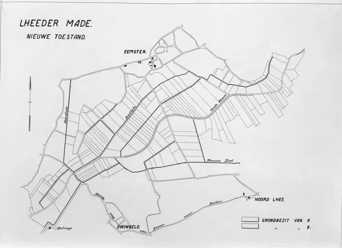
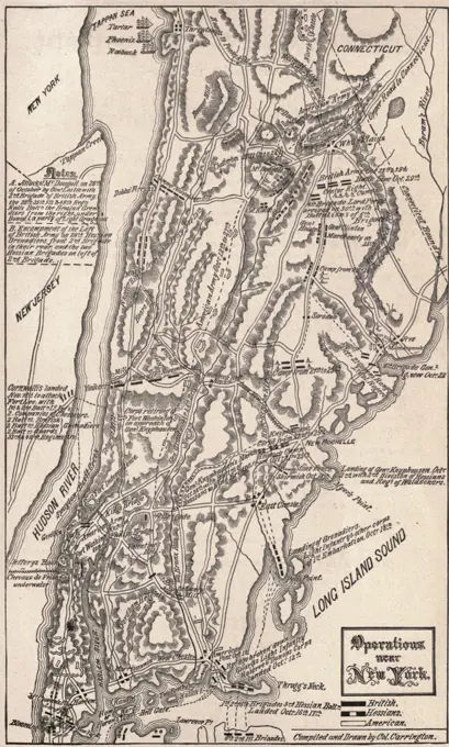
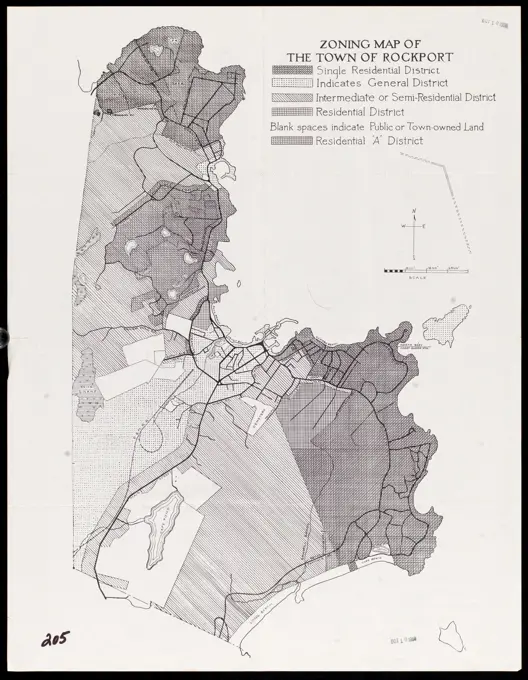
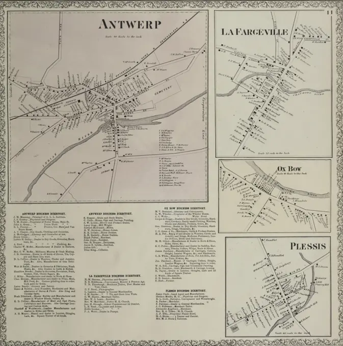
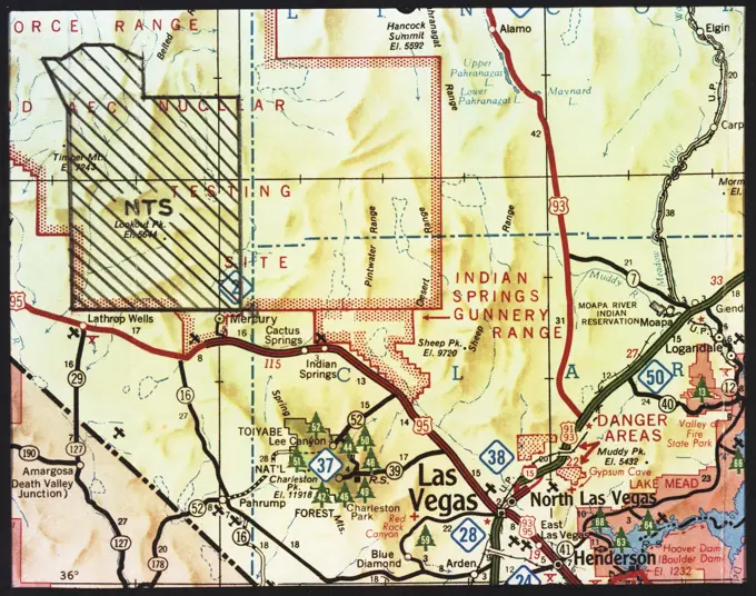
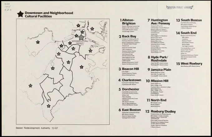
Cadastral And Urban Maps

Historical plans and maps depicting urban development and land use, showcasing cartographic detail and urban planning.

Government Center project Mass. r-35 : utility map , Government Center Boston, Mass., Maps, City planning, Massachusetts, Boston, Maps, Urban renewal, Massachusetts, Boston, Maps, Sewerage, Massachusetts, Boston, Maps, Underground utility lines, Massachusetts, Boston, Maps
168 assets in this story
6145-48580872
Sequence of land purchases , Armories, Plans, Land tenure, Watertown Arsenal Mass..  Records of U.S. Army Operational
6145-48467026
Rüster Emil (1883-1949), expansion of the farm building in Greifenberg (approx. 1905-1909): site plan 1: 500. Ink on transparent, 38 x 26 cm (including scan edges)
6176-66089588
Old plan of the city of Samarkand, Uzbekistan, Central Asia. From Orenburg to Samarkand 1876-1878 by Madame Marie Ujfalvy-Bourdon, Le Tour du Monde 1879
6145-30115772
Loose fragments of a print of a lion ..
6145-48434464
Koppen, garrison hospital in Göttingen (1902-1904): site plan 1: 250. Lithograph, 69 x 58 cm (including scan edges)
6145-54522556
Cartographic, Maps. 1860. Lionel Pincus and Princess Firyal Map Division Map bounded by Front St, Peck Slip, Peck Slip Ferry, Pier - Line 13-26; Including Gouverneurs Lane, Jones Lane, Wall St, Wall St Ferry, Pine St, Depeyster St, Maiden Lane, Fletcher St, Burling Slip, Fulton St, Fulton Ferry, Beekman St
6145-48449168
Schultze, barracks (garrison), Sperenberg (December 31, 1905): site plan 1: 1000. Lithography watercolor on the box, 60.7 x 74 cm (including scan edges) Schultze : Kaserne (Garnison), Sperenberg
6145-55917740
Washington Park urban renewal area Massachusetts r-24 : property map acquisitions. Shows streets, land lots and size, building footprints, assessor's block numbers and names of various institutions. Does NOT indicate property to be acquired described in title or land use designation described in legend. Inset: Location map.... , Massachusetts  , Suffolk  ,county   , Boston  , Roxbury
6145-48447164
Jansen Hermann (1869-1945), Bamberg development plan (April 11, 1932): Transport plan 1: 2500. Light break on transparent, 75.6 x 62.5 cm (including scan edges) Jansen Hermann  (1869-1945): Bebauungsplan Bamberg
6176-67049511
Plan of the proposed Thames Embankment, London, 1861. Map showing '...plans for embanking the River Thames within the metropolis, so as to provide with the greatest efficiency and economy for the relief of the most crowded streets, by the establishment of a new and spacious thoroughfare, for the improvement of the navigation of the river, and which will afford an opportunity of making the low-level sewer without disturbing the Strand or Fleet-street, and also to report upon the cost and means of carrying the same into execution'. From "Illustrated London News", 1861.
6145-48483881
N.N., Development of the railway systems in the north of Berlin. (From: Atlas to the magazine for Building, ed. V. Ministry of Public Works, Jg. 53, 1903): Site plans, cuts. Stitch on paper, 44.7 x 59.4 cm (including scan edge). Architecture Museum of the Technical University of Berlin Inv. No. ZFB 53.033. N.N. : Entwicklung der Eisenbahnanlagen im Norden von Berlin. (Aus: Atlas zur Zeitschrift für Bauwesen, hrsg. v. Ministerium der öffentlichen Arbeiten, Jg. 53, 1903)
6145-48447146
Jansen Hermann (1869-1945), distribution plan of the Prince Hardenberg Forest District on Dehmsee, Fürstenwalde/Spree (July 26, 1930): Preliminary draft road tour and green plan, map 1: 10000. Colored pencil and pencil on transparent, 36 x 43 cm (including scan edges) Jansen Hermann  (1869-1945): Aufteilungsplan des fürstlich Hardenbergischen Forstbezirks am Dehmsee, Fürstenwalde/Spree
6145-29620448
Collection of the Dutch Heidematschappij. Hollum Ameland. Run allotment Hollumer Maten: Old condition. undated. Ameland, Hollum
6145-51386808
Public open space city of Boston , Boston Mass., Maps, Open spaces, Massachusetts, Boston, Maps
6145-50568292
Plan of the city of Hartford from a survey made in 1824 , Hartford Conn., Maps Norman B. Leventhal Map Center Collection
6145-42606325
Unknown architect, blueprint for a settlement of the Abegg Foundation (with a normal home) in Gdansk. Monthly competition June 1877 (06.1877): site plan; 2 scale strips, calculation (z. T. cut off). Tusche watercolor on paper, 54.6 x 41.4 cm (including scan edges) N.N. : Bauplan für eine Siedlung der Abegg-Stiftung (mit einem Normal-Wohnhaus), Danzig. Monatskonkurrenz Juni 1877
4443-75460830
Hastings Village; Hastings Business Directory; Bernhards Bay Business Directory; Bernhards Bay Village; Fort Brewerton Village; Fort Brewerton Business Directory; Caughdenoy Village; Caughdenoy Business Directory; Central Square Business Directory; Central Square Village, 1867, Stone, C. K., 1867, Philadelphia, Publisher, C. K. Stone, Oswego County (N.Y.), Real property, New York (State), Oswego County, Business enterprises, New York (State), Oswego County
6145-48592024
Suggestion for the improvement of Muddy River and for completing a continuous promenade from the Common to Jamaica Pond , Parks, Massachusetts, Boston, Maps, City planning, Massachusetts, Boston, Maps, Landscape architecture, Massachusetts, Boston, Maps, Muddy River Norfolk County and Suffolk County, Mass. : River, Maps, Boston Mass., Maps Norman B. Leventhal Map Center Collection
6145-48486618
N.N., Oder-Spree Canal. Route Friedrich-Wilhelm-Canal or Schlaubehammer to Fürstenberg/Oder (07.1890): Department 1: 2500. Lithograph on paper, 47.1 x 65.4 cm (including scan edges) N.N. : Oder-Spree-Kanal. Strecke Friedrich-Wilhelm-Kanal bzw. Schlaubehammer bis Fürstenberg/Oder
6145-42603510
Jansen Hermann (1869-1945), Hagen development plan (1931-1931): Worksheet basic map without altitude lines, department 222, sheet 13 1: 2000. Lithograph on paper, 56.3 x 101.3 cm (including scan edges) Jansen Hermann  (1869-1945): Hagen Bebauungsplan
6145-29620504
Collection of the Dutch Heidematschappij. new condition. undated. Dwingeloo, Eemster, North Lhee
6145-55927137
New York (N.Y.). Board of Estimate and Apportionment. Cartographic, Maps. 1916. Lionel Pincus and Princess Firyal Map Division. Zoning , New York (State) , New York, Maps Use District Map Section No. 9
6176-66917543
Map of Operations near New York, Harlem Heights and White Plains, during the American Revolution
6176-67046857
'Plan of the Wards and Parishes in Which the Guildhall of the City of London is Situated', 1886. Artist: Unknown
6145-48716119
L'Acropole D'Athenes d'après I. A. Kaupert , Forts & fortifications, Maps. Nicholas Catsimpoolas Collection
4409-50120378
Plaza de Castelar seen from the bank of the River Plate (on these lines). Photoplan of Madrid from 1929 (Bottom image).
6145-51937877
Sweden, Blekinge, Blekinge, Karlskrona, Karlskrona, external marina (depicted, town).Sweden, Blekinge, Blekinge, Karlskrona, Karlskrona, External War Gogs (depicted, City)
6145-58895960
Zoning map of the Town of Rockport. Zoning map of the Town of Rockport
6145-54524503
Cartographic, Maps. 1884 - 1936. Lionel Pincus and Princess Firyal Map Division. Fire insurance , New York (State), Real property , New York (State), Cities & towns , New York (State) Queens V. 5, Plate No. 33 Map bounded by Whitestone Ave., Higgins Lane, Murray St., Mitchell Ave.
6145-55920719
Manorialism, A Typical Manor. Original caption: From page 335 - An Introduction to Medieval Europe (300-1500) by James Westfall Thompson and Edgar Nathaniel Johnson - 1937.
6145-55170058
Proposed location of Beaver Creek. State: Alaska.
6145-42605698
Röhlike Hans, installation of a well (without date): site plan, 1: 250. Tusche watercolor on the box, 67.2 x 49.9 cm (including scan edges) Röhlike Hans : Aufstellung eines Brunnens
4409-29975445
PLANO-CARTA DE LA COSTA DE FLANDES-163. Author: JACOBUS VAN DER WALLE. Location: ARCHIVO-COLECCION. Simancas. Valladolid. SPAIN.
6145-54522869
Cartographic, Maps. 1918. Lionel Pincus and Princess Firyal Map Division. Queens (New York, N.Y.), Real property , New York (State) , New York , Queens (Borough) Queens, Vol. 1A, Double Page Plate No. 29; Part of Ward 4 Jamaica. Map bounded by Rockaway Blvd., Meadow Rd., New Lane, Meadow Lane; Sub Plan From Plate No. 32.;Map bounded by Hook Creek, Rockaway Turnpike, 1st St., Dock St., 2nd St., Plaza
6145-29929763
Neighborhoods Rochechouart and Saint Vincent-de-Paul (City of Paris) / Sheet 27-37
6145-30278814
Emperor Franz Josef-Stadtmuseum, big project, first variant, partial floor plan and situation plan of the area, Otto Wagner -, architect
6145-29305043
Anefo photo collection. Development Front Surabaia. Secret. February 5, 1948
6145-29658269
Collection of the Dutch Heidematschappij. Exchange graves, overview cards. undated
6145-29095495
1868 Shannon and Rogers Map of New York City (Manhattan)
6145-29623368
Collection of the Dutch Heidematschappij. Maps, archive numbers. undated
6145-48448778
Jansen Hermann (1869-1945), total development plan Ceyhan (1937-1937): Planning document Old city: basic ticket extract 1: 5000, scale bar. Ink on transparent, 71.3 x 88.3 cm (including scan edges) Jansen Hermann  (1869-1945): Gesamtbebauungsplan Ceyhan
1848-49439052
Aeronautical chart, map designed to assist in navigation of aircraft
6145-50562660
Precinct atlas, Town of Wakefield , Election districts. Lucius Beebe Memorial Library Historic Maps
6145-51386691
Precinct atlas, Town of Wakefield , Election districts. Lucius Beebe Memorial Library Historic Maps
6145-51395247
Map of Vienna, Me , Landowners, Maine, Vienna, Maps, Vienna Me., Maps Norman B. Leventhal Map Center Collection
6145-54371397
Tree Identification - Pine, Western White. Photographs Relating to National Forests, Resource Management Practices, Personnel, and Cultural and Economic History
1525-27876950
Map of the fortifications of Paris, vintage engraved illustration. Magasin Pittoresque 1841.
4443-75475392
Antwerp Village; La Fargeville Village; Ox Bow Village; Antwerp Business Directory; La Fargeville Business Directory; Ox Bow Business Directory; Plessis Business Directory; Plessis Village, 1864, 1864, Philadelphia, Publisher, C.K. Stone, Jefferson County (N.Y.), Real property, New York (State)
1848-53925390
Display chart, docks, illustration, Meyers Konversations-Lexikon encyclopedia, 1897
6145-53191192
Sign with map of Oxelösund harbor.
1525-75971103
Detailed navigation black lines urban street roads map of the GROSS GAGLOW DISTRICT of the German town of COTTBUS, Germany on vintage beige background
1746-29961387
A plan for transport of water across Mars by means of canals and reservoirs. Dated 20th century
6145-48455210
N.N., Plan of a cemetery system (without date): Plan content N.N. detected. Material/technology N.N. recorded, 192.2 x 121.8 cm (including scan edges) N.N. : Friedhof Ohlsdorf, Hamburg
6145-29623451
Collection of the Dutch Heidematschappij. land consolidation. undated
6145-48473804
Böhmer Franz (1907-1943), urban planning, bipial task 3 summer semester 1932 (April 22, 1932): Task. Pencil over pressure on paper, 56.7 x 72.9 cm (including scan edges)
6145-29658136
Collection of the Dutch Heidematschappij. Land resumptions, overview cards, Havelter Made. undated. Havelter Made
6188-60958315
Architectural plan of city streets Master plan of Barnaul city. Town streets on the plan. Map of the scheme of road. Urban environment, architectural general layout. Copyright: xZoonar.com/JuryxParmenovx 16331332
6145-48447544
Jansen Hermann (1869-1945), Planning for Plowdiw (1937-1937): Plowdiw zone plan and the surrounding area in 16 parts, part 4C 1: 5000. Ink over pressure on transparent, 50.5 x 74.6 cm (including scan edges) Jansen Hermann  (1869-1945): Planung für Plowdiw
6145-29658102
Collection of the Dutch Heidematschappij. new condition. undated. Overijssel, Staphorst
6145-44082893
Meissen in the Middle Ages
6145-50602012
A761622 VIEWGRAPH PRESENTATION MAP OF LAS VEGAS & NTS DOLCE(Project Engineer) DEC 23 76EG&G/NTS PHOTO LAB Publication Date: 12/23/1976  EDGERTON, GERMESHAUSEN & GRIER; EG&G; LAS VEGAS; MAPS; NEVADA; NEVADA TEST SITE; NTS; NUCLEAR ENERGY TECHNOLOGY; PRESENTATIONS; TEST SITES; VIEWGRAPHS; MAP OF LAS VEGAS & NTS  historical images. 1972 - 2012. Department of Energy. National Nuclear Security Administration. Photographs Related to Nuclear Weapons Testing at the Nevada Test Site.
6145-29658091
Collection of the Dutch Heidematschappij. new condition. undated. Overijssel, Staphorst
6145-55133370
Landing Fields - Philippines - Calamba, Aerial Photograph.
6145-29208408
Fragment of Mail 17th-18th century probably European From about the third century B.C. through the early fourteenth century A.D., mail, also called chain mail, was the predominant and most effective type of body armor known in Europe. From about the mid-fifteenth century onward, mail was used in conjunction with full plate armor to fill the gaps between plates. Separate mail sleeves were made to be worn with a cuirass (breastplate and backplate); shaped panels of mail called gussets, covered the armpits or the crooks of the elbows and were attached to arming jackets, garments specially tailored to be worn under armor; and mail breeches, called brayettes or pairs of paunces, could be worn by men fighting on foot.. Fragment of Mail. probably European. 17th-18th century. Steel. Mail
6145-42603631
Jansen Hermann (1869-1945), total development plan Ankara. Partial development plan Altstadt (04.05.1932): Overview plan 1: 4000, old town between the street d. Mukaddem C. and Hacet Tepe. Bleisite on transparent, 18 x 35.7 cm (including scan edges) Jansen Hermann  (1869-1945): Gesamtbebauungsplan Ankara. Teilbebauungsplan Altstadt
6145-52593525
Creator: US Fish and Wildlife Service. Subjects: Maps; Refuge Maps; Refuge Map; Nevada.  . 1998 - 2011.
6145-48652339
Downtown and neighborhood cultural facilities , Boston Mass., Maps, Arts facilities, Massachusetts, Boston, Maps, City planning, Massachusetts, Boston, Maps, Urban renewal, Massachusetts, Boston, Maps, Library buildings, Massachusetts, Boston, Maps, Church buildings, Massachusetts, Boston, Maps
6145-48685000
Downtown and neighborhood cultural facilities , Boston Mass., Maps, Arts facilities, Massachusetts, Boston, Maps, City planning, Massachusetts, Boston, Maps, Urban renewal, Massachusetts, Boston, Maps, Library buildings, Massachusetts, Boston, Maps, Church buildings, Massachusetts, Boston, Maps
PREVIOUS
of 2
NEXT
2401 S. Ervay, Suite 206
Dallas, Texas 75215
United States
Get Started
Free ResearchMy BoardsMy Cart
For Creators
How To License Your ContentContributor PortalFrame of Mind
Resources
API accessPricing
Contact
+1 866 236 0087help@viewpictures.co.uk Contact form
©2026 View Pictures. All Rights Reserved. -A
This site is protected by reCAPTCHA and Google Privacy Policy and Terms of Service apply.