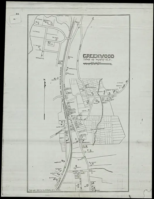
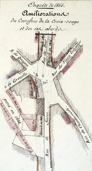
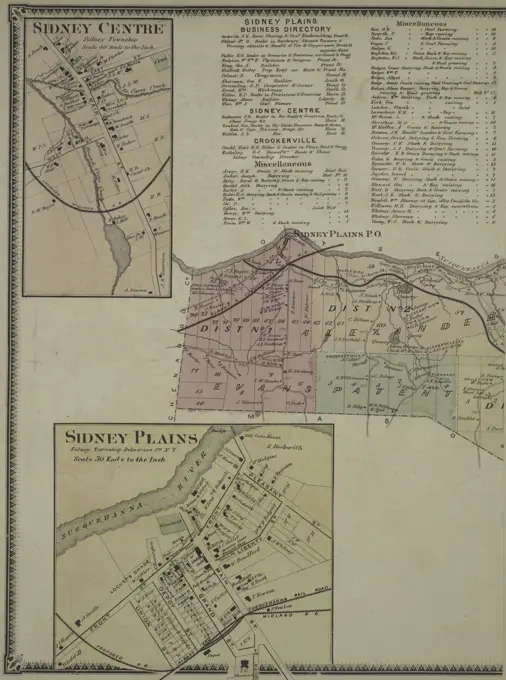
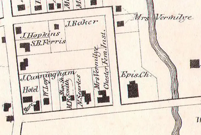
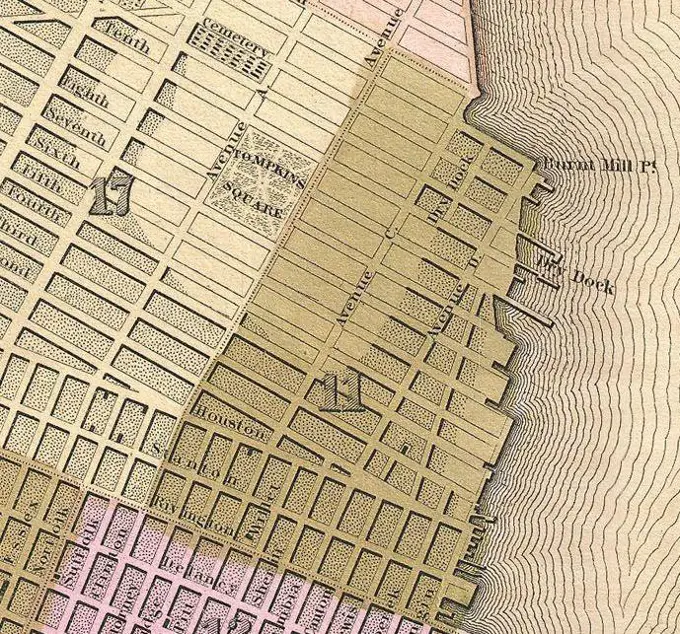
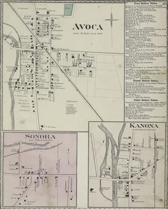
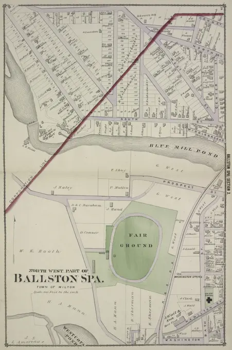
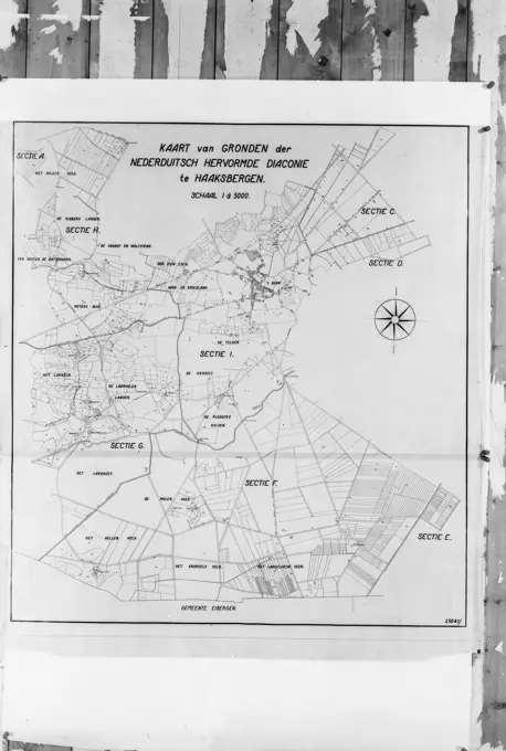
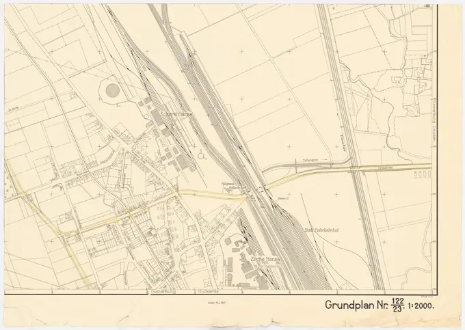
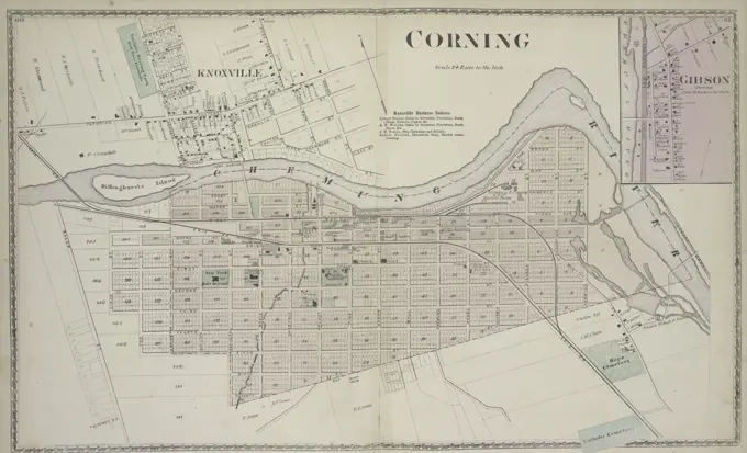
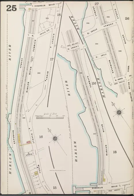
My Boards
View Pictures
  • My Boards

City Maps and Plans

Detailed cartographic representations from various regions, showcasing urban landscapes, property boundaries, and infrastructure developments in historical contexts.

Cartographic, Maps. 1900. Lionel Pincus and Princess Firyal Map Division. Fire insurance , New York (State), Real property , New York (State), Cities & towns , New York (State) Bronx, V. 13, Plate No. 25 Map bounded by Fordham Rd., Harlem River
371 assets in this story
6145-50661847
Collection card with the distribution of the cadastral municipality of Lauwerecht in the Section A in three magazines, largely according to the minute plan.n.b. The Utrecht - Amersfoort railway line has been signed.
6145-50545331
Greenwood, Town of Wakefield Massachusetts ,. Lucius Beebe Memorial Library Historic Maps
6145-54549950
Hempstread Gardens; Forest Park Cartographic. Atlases, Maps. 1914. Lionel Pincus and Princess Firyal Map Division. Nassau County (N.Y.) , Maps, Real property , New York (State) , Nassau County
4443-75457876
Westfield Village; Silver Creek Village; Business Directory, 1867, Wm. Stewart, Publisher, Philadelphia, Chautauqua County, New York
6145-48434117
Unknown architect, Reiherstehr-Brezrschleuse in Hamburg-Harburg (approx. 1904/1905): site plan 1: 4000. Lithograph, 51.3 x 71 cm (including scan edges)
6145-59017702
Leymonnerye. "Plan of the crossroads of the Red Cross and its surroundings". Paris (6th arr.), 1866. Drawing. Paris, Carnavalet museum. 35299-4 Improvement, crossroads crossroads, drawing, investigation, plan, second empire, life VI 6th 6th 6 arrondissement, roads
6145-54524476
Cartographic, Maps. 1884 - 1936. Lionel Pincus and Princess Firyal Map Division. Fire insurance , New York (State), Real property , New York (State), Cities & towns , New York (State) Queens V. 5, Plate No. 8 Map bounded by Ehret Ave., Jackson Blvd., Old Bowery Rd., Flushing Ave.
6145-29583211
Labor Inspectorate Photo Collection. 5x5 Drawing labor inspectorate fatal accident 4 1950 sand quarry .h. Donners Sweikhuizen - Schinnen. undated. Schin
6145-55181606
Tonawanda Falls Village; Byron Center Village; Harris Mills Village Cartographic. Atlases, Maps. 1876. Lionel Pincus and Princess Firyal Map Division. Genesee County (N.Y.), Real property , New York (State)
6145-48449240
Unknown architect, government building in Stralsund. Main cash building (01.05.1890): floor plan 2nd floor 1: 100. Ink colored, about lithography on paper, 69 x 51.2 cm (including scan edges) N.N. : Regierungsgebäude, Stralsund. Hauptkassengebäude
6145-48717799
Atlas of the city of Boston, ward 25, Brighton : plate 29 , Boston Mass., Maps, Real property, Massachusetts, Boston, Maps, Landowners, Massachusetts, Boston, Maps, Allston Boston, Mass., Maps Norman B. Leventhal Map Center Collection
6145-51394573
Map of Chickamauga & Chattanooga National Park , Chickamauga and Chattanooga National Military Park Ga. and Tenn., Maps, Georgia, History, Civil War, 1861-1865, Maps, Tennessee, History, Civil War, 1861-1865, Maps Norman B. Leventhal Map Center Collection
6145-48446975
Jansen Hermann (1869-1945), Hagen development plan (1931-1931): Worksheet basic map without altitude lines, department 222, sheet 19 1: 2000. Lithograph on paper, 76.4 x 100.8 cm (including scan edges) Jansen Hermann  (1869-1945): Hagen Bebauungsplan
6145-55927053
New York (N.Y.). Board of Estimate and Apportionment. Cartographic, Maps. 1916. Lionel Pincus and Princess Firyal Map Division. Zoning , New York (State) , New York, Maps Area District Map Section No. 1
6145-48717974
Plan of Milton Cemetery , Cemeteries, Massachusetts, Milton, Maps, Milton Mass., Maps Norman B. Leventhal Map Center Collection
4443-75475209
Mining district of Rossie, 1838, Adirondack Mountains, New York
4443-75461480
Sidney Centre Village; Sidney Plains Business Directory; Sidney Township; Sidney Plains Village, 1869., 1869., New York. Publisher, Published by F. W. Beers, A. D. Ellis & G. G. Soule, Delaware County (N.Y.)
6145-29096603
1867 Beers North Castle map Armonk closeup
6145-55957613
Part of Town of Brookhaven Cartographic. Atlases, Maps. 1915 - 1917. Lionel Pincus and Princess Firyal Map Division. Suffolk County (N.Y.)
6145-48446866
Jansen Hermann (1869-1945), Böckmannshof, Babelsberg/Berlin-Wannsee. Parceling of the bank area between Kreisstraße and Griebnitzsee (08.10.1925): Creation of the residential streets and distribution plan 1: 1000. Ink on transparent, 66.6 x 99.3 cm (including scan edges) Jansen Hermann  (1869-1945): Böckmannshof, Babelsberg/Berlin-Wannsee. Parzellierung des Ufergeländes zwischen Kreisstraße und Griebnitzsee
6145-55958986
Village of Port Ontario, in the Town of Richland and County of Oswego Cartographic. Maps, Cadastral maps. 1836. Lionel Pincus and Princess Firyal Map Division. Real property , New York (State) , Port Ontario, Landowners , New York (State) , Port Ontario, Port Ontario (N.Y.), Mexico (N.Y. : Town)
6145-48447697
Jansen Hermann (1869-1945), total development plan Ankara. Partial development plan Outer Stadt (March 18, 1932): Basic plan 1: 4000, area west of the Necati Bey Caddesi and northwest of the new Dikmen Caddesi. Pencil and colored pencil on transparent, 32.2 x 22 cm (including scan edges) Jansen Hermann  (1869-1945): Gesamtbebauungsplan Ankara. Teilbebauungsplan äußere Stadt
6145-50561087
Mass pike air rights study , Airspace Law, Massachusetts, Boston, Maps, Massachusetts Turnpike Boston, Mass., Maps, City planning, Massachusetts, Boston, Maps, Boston Mass., Maps
6145-54522493
Cartographic, Maps. 1880. Lionel Pincus and Princess Firyal Map Division. Brooklyn (New York, N.Y.), Real property , New York (State) , New York Vol. 2. Plate, C. Map bound by Division Pl., Newtown Creek, Orient St., Vandervoort Ave.; Including Amos St., Bennett St., Parker St., Benton St., Bullion St., Maspeth St., Porter Ave., Varick Ave., Stewart Ave., Cardner Ave., Scott Ave., Seneca Ave.
6145-55914744
Map of the city of Cambridge. Relief shown by contours. Oriented with north toward the upper left. Shows fire alarm boxes and strikers, city wards and lines, street railways, some buildings, and radial distances from City Hall.... , Massachusetts  , Middlesex  ,county   , Cambridge
6145-48446967
Jansen Hermann (1869-1945), Hagen development plan (1931-1931): Worksheet basic map without altitude lines, department 222, sheet 24 1: 2000. Lithograph on paper, 76.7 x 101.2 cm (including scan edges) Jansen Hermann  (1869-1945): Hagen Bebauungsplan
6145-52359823
Catharine Business Notices; Odessa Village; Beaver Dams Village; Catharine Village; Cayutaville Village Cartographic. Atlases, Maps. 1874. Lionel Pincus and Princess Firyal Map Division. Schuyler County (N.Y.), New York (State) , Schuyler County
6145-29658125
Collection of the Dutch Heidematschappij. Land consumer, overview maps, Merre Made. undated. Merre Made
6145-55924688
Cartographic, Maps. 1901. Lionel Pincus and Princess Firyal Map Division. Bronx (New York, N.Y.), Real property , New York (State) , New York Double Page Plate No. 40, Part of Ward 24, Section 12. Bounded by Jerome Ave. and Van Cortlandt Park South.
6145-52945195
Yard Plan. Glass Plate Negatives of the Construction and Repair of Buildings, Facilities, and Vessels at the New York Navy Yard.
6145-54396468
Public Relations - District of Columbia. Photographs Relating to National Forests, Resource Management Practices, Personnel, and Cultural and Economic History
6145-48475171
Böhmer Franz (1907-1943), Haus Schwanenwerder in Berlin-Wannsee (without dat.): Site plan 1: 500. Pencil, colored pencil on transparent, 33.4 x 27.2 cm (including scan edges) Böhmer & Petrich : Haus Schwanenwerder, Berlin-Nikolassee
6145-48719402
Atlas of the county of Suffolk, Massachusetts : vol. 4th including East Boston, city of Chelsea, Revere and Winthrop : from actual survey official records & private plans : plate N , Real property, Massachusetts, Boston, Maps, Landowners, Massachusetts, Boston, Maps, East Boston Boston, Mass., Maps Norman B. Leventhal Map Center Collection
6145-55956209
A3 Cartographic. Maps. 1799. Carl H. Pforzheimer Collection of Shelley and His Circle. London (England), Fire risk assessment , England , London
6145-54523772
Cartographic, Maps. 1884 - 1936. Lionel Pincus and Princess Firyal Map Division. Fire insurance , New York (State), Real property , New York (State), Cities & towns , New York (State) Brooklyn, V. 9, Double Page Plate No. 234 Map bounded by Anthony St., Sutton St., Nassau Ave., Varick Ave.
6145-54523051
Cartographic, Maps. 1884 - 1936. Lionel Pincus and Princess Firyal Map Division. Fire insurance , New York (State), Real property , New York (State), Cities & towns , New York (State) Brooklyn Plate No. 17 Map bounded by Columbia St., Halleck St.
6145-48732615
Plan of a proposed new wharf in Long Cove, Rockport, Mass., laid out by the Sandy Bay Pier Company , Piers & wharves
6145-50511685
Plan of sea-shore cottage lots near Gully Point, Rockport, owned and for sale by Sumner D. York ,
6145-50530027
Atlas of the county of Suffolk, Massachusetts : vol. 6th including the late city of Charlestown, now wards 20,21 and 22, city of Boston : from actual survey & official records : plate N , Real property, Massachusetts, Boston, Maps, Landowners, Massachusetts, Boston, Maps, Charlestown Boston, Mass., Maps Norman B. Leventhal Map Center Collection
6145-30305208
Veitsch cadastral plan Stmk,
6145-29096647
1839 Bradford Map of New York City, New York
6145-48732652
Plan of the highway in Rockport, Mass. from Prospect St. to Horace Lane's barn , Streets
4443-75475700
Map of Site appropriated by the Commissioners of Public Parks for the New York Botanical Garden., 1896
6145-29657291
Collection of the Dutch Heidematschappij. Maps, water boards, South Koekange. undated. South Koekange
4443-75462770
A historical document or map from 1873 published by D.G. Beers & Co. in Philadelphia, featuring Avoca Village, Kanona Village, Sonora Village, and associated business notices. It pertains to real property and business enterprises in Steuben County, New York
6145-48486930
N.N., Oder-Spree Canal. Route Schlaubehammer to Fürstenberg/Oder: Stat. 81.6 - 83.1: site plan 1: 2500. Lithograph on paper, 47.5 x 64.9 cm (including scan edges) N.N. : Oder-Spree-Kanal. Strecke Schlaubehammer bis Fürstenberg/Oder
6145-48450844
Unknown architect, Gartenstadt Falkenberg in Berlin-Altglienicke (1947): cadastral plan district of Altglienicke. Light break watercolored on paper, 92.1 x 105.3 cm (including scan edges) N.N. : Gartenstadt Falkenberg, Berlin-Altglienicke
4443-75471897
North West part of Ballston Spa, Village, 1876., 1876., New York. Publisher, J.B. Beers. Real property, New York (State)
6145-48717649
Atlas of the city of Boston : city proper and Roxbury : plate 11 , Boston Mass., Maps, Real property, Massachusetts, Boston, Maps, Landowners, Massachusetts, Boston, Maps, Beacon Hill Boston, Mass., Maps Norman B. Leventhal Map Center Collection
4220-2682
A map of New York.Date: 1782-5
6145-29657447
Collection of the Dutch Heidematschappij. Maps, overviews, Nederduitsch Reformed diaconia. undated. Haaksbergen
6145-48447366
Jansen Hermann (1869-1945), Dortmund development plan (16.02.1937): External districts, map section 122/23 1: 2000. Colored pencil and pencil over pressure on paper, 69.1 x 97.2 cm (including scan edges) Jansen Hermann  (1869-1945): Bebauungsplan Dortmund
6145-54549554
Cohoes Village; Cohoes Business Directory Cartographic. Atlases, Maps. 1866. Lionel Pincus and Princess Firyal Map Division. Albany County (N.Y.), Cohoes (N.Y.)
6145-52359844
Branchburg Village; Ocean Township Business Notices. ; Oceanville Village Cartographic. Atlases, Maps. 1873. Lionel Pincus and Princess Firyal Map Division. Monmouth Couty (N.J.) , Description and travel, Real property , New Jersey , Monmouth County
4409-21522290
Manhattan, V. 12, Plate No. 11 Map bounded by Hudson River, Riverside Drive.
6145-48982898
Map of the Oudegracht in Utrecht with display of the plots (ged.) With yard cellars, with house and cadastral numbers and designation in the color of the municipal and private property. With Legenda.blad II: part between Maartensbrug and Bijhouwerstraat.
6145-45870547
Map of Hellevoetsluis, ca. 1701-1715; Helvoetsloys. Map of the reinforcements to the city of Hellevoetsluis, ca. 1701-1715. At the bottom left of a cartouche with the legend A-H in Dutch, worn on the shoulders by a sea god. Part of a collection of signed plans of reinforced places in the Netherlands and surrounding countries at the time of the Spanish Succession War (Part A).
6145-52359489
Village of Livingston's Landing, in the town of Greenburg : 22 miles from the city of New York Cartographic. Maps. 1840. Lionel Pincus and Princess Firyal Map Division. Dobbs Ferry (N.Y.) , Maps, Greenburgh (N.Y. : Town) , Maps, Landowners , New York (State) , Dobbs Ferry, Real property , New York (State) , Dobbs Ferry
6145-54549921
Greenfield Cartographic. Atlases, Maps. 1914. Lionel Pincus and Princess Firyal Map Division. Nassau County (N.Y.) , Maps, Real property , New York (State) , Nassau County
6145-52359825
Cokesburgh Village; Glen & Clarksville Business Notices. ; Glen Gardner Village; Clarksville Village Cartographic. Atlases, Maps. 1873. Lionel Pincus and Princess Firyal Map Division. Hunterdon County (N.J.) , Maps
6145-50527298
Ward 1 of Boston , Election districts, Massachusetts, Boston, Maps, Boston Mass., Administrative and political divisions, Maps Norman B. Leventhal Map Center Collection
4443-75477754
Corning Village; Gibson Village, 1873, D.G. Beers & Co., 1873, Philadelphia; Publisher, D.G. Beers; Steuben County (N.Y.); Real property; Business enterprises, New York (State); Steuben County
6145-55956933
Map of Carl Schurz Park 1914. Cartographic. Maps. Lionel Pincus and Princess Firyal Map Division
6145-29909625
Demonstration in honor of Baudin on December 2, 1888. (IT)
6145-42638646
Bahnhof, Kassel-Unterstadt: Freight Station: Site Plan and Track Plan 1: 500
6145-53129749
Reproduct of map sketch ur day news.
6145-48500671
Rohscan
6145-29623367
Collection of the Dutch Heidematschappij. new condition. undated. Nieuwleusen
6145-50530107
Atlas of the towns of Revere and Winthrop, Suffolk County, Massachusetts. sheet 17 , Real property, Massachusetts, Revere, Maps, Landowners, Massachusetts, Revere, Maps, Revere Mass., Maps Norman B. Leventhal Map Center Collection
6145-42603469
Jansen Hermann (1869-1945), construction of a settlement for the non-profit small house construction company in Berlin-Heiligensee (04.1922): Basic plan 1: 2500 (from Inv.No. 21111). Light break on paper, 26.4 x 48.6 cm (including scan edges) Jansen Hermann  (1869-1945): Bau einer Siedlung für die gemeinnützige Kleinhausbaugesellschaft, Berlin-Heiligensee
6145-48439376
Jansen Hermann (1869-1945), urban planning in Adana. City Review district north after the old city (April 17, 1937): Breaker break from Inv.No. 23365: 2nd version: Two basic plans, partly location plans 1: 2000, tabular comparison of the area shares. Light break on paper, 60.4 x 95.1 cm (including scan edges) Jansen Hermann  (1869-1945): Stadtplanung, Adana. Stadterweiterugsquartier nördlich im Anschluss an die alte Stadt
PREVIOUS
of 4
NEXT
2401 S. Ervay, Suite 206
Dallas, Texas 75215
United States
Get Started
Free ResearchMy BoardsMy Cart
For Creators
How To License Your ContentContributor PortalFrame of Mind
Resources
API accessPricing
Contact
+1 866 236 0087help@viewpictures.co.uk Contact form
©2026 View Pictures. All Rights Reserved. -A
This site is protected by reCAPTCHA and Google Privacy Policy and Terms of Service apply.