My Boards
View Pictures
  • My Boards
← Documents & Records

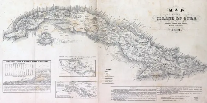
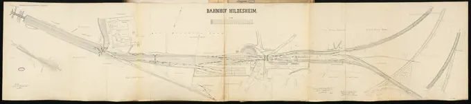
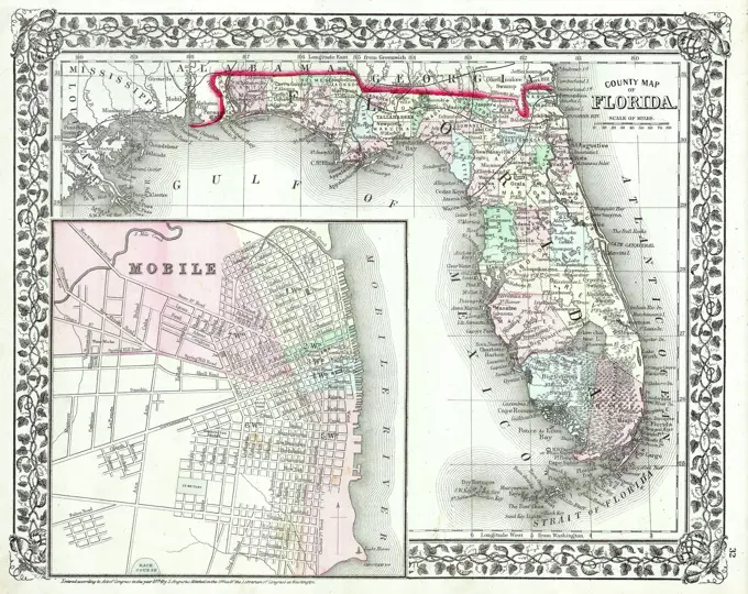
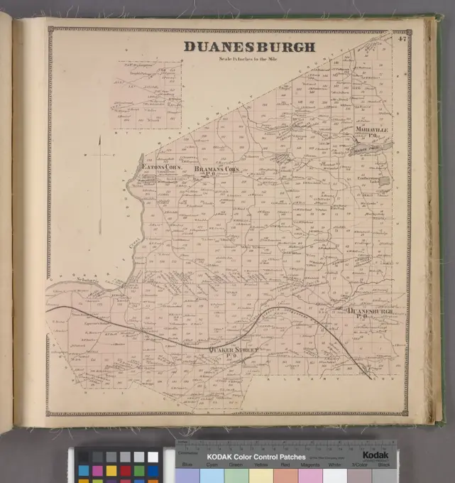
Early American Military Maps

Maps detailing military operations and local geography in early America, showcasing historical sieges and explorations in various regions.

Plan of Dedham made by John G. Hales, dated 1831.... , Massachusetts  , Norfolk  ,county   , Dedham
Plan of Dedham made by John G. Hales, dated 1831.... , Massachusetts , Norfolk ,county , Dedham
257 assets in this story
6145-50535337
Chart of the coast of America from Cape Hateras to Cape Roman , Coasts, North Carolina, Maps, Early works to 1800, Coasts, South Carolina, Maps, Early works to 1800, North Carolina, Maps, Early works to 1800, South Carolina, Maps, Early works to 1800 Norman B. Leventhal Map Center Collection
6145-55166952
Chart of the coast of America from Cape Hateras to Cape Roman. Depths shown by soundings. Includes illustrations of ships and a sea monster. In Norman's The American pilot. Boston : William Norman, 1798.... , North Carolina South Carolina
6145-54602637
Map of northern Luzon
6145-50511196
Plan of Charles River : from the Waltham line to Boston harbor , Charles River Mass., Maps Norman B. Leventhal Map Center Collection
6145-54549082
Beekmantown Corners Village; Beekmantown Subscriber's Business Directory.; Elsinore Subscriber's Business Directory.; Cadyville Subscriber's Business Directory.; East Beekmantown Village; Morrisonville Village; Elsinore & Cadyville Village; Beekmantown Township; West Plattsburgh Village; Plattburgh Subscriber's Business Directory. Cartographic. Atlases, Maps. 1869. Lionel Pincus and Princess Firyal Map Division. Clinton County (N.Y.)
6145-48718488
Plan of Mystic River showing the Harbor Commissioners lines : Dec. 1854 , Harbors, Massachusetts, Boston, Maps, Mystic River Mass., Maps Norman B. Leventhal Map Center Collection
6145-59618035
Map with two images of places along the Thames, in or after 1878 - in or before 1879 photomechanical print. print Left: View of a park at Ankerwycke, right: View of the Magna Carta Island. Berkshirepublisher: LondonLondon paper engraving river. island Magna Carta Island
6145-55927051
New York (N.Y.). Board of Estimate and Apportionment. Cartographic, Maps. 1916. Lionel Pincus and Princess Firyal Map Division. Zoning , New York (State) , New York, Maps Area District Map Section No. 2
4443-75476881
A map of the Genesee County, New York State, published in 1849 by Weed, Parsons & Co. It features the Genesee Region and the Finger Lakes Region. The dimensions of the map are 10 x 16 cm, printed on a sheet measuring 14 x 21 cm
6145-45552626
Bliżej Kultury Sonrel, A. (Fl. CA 1840 1843), Dubois de Montpéreux, Frédéric (1798 1850), lithography of H. Nicolet (Neuchtel)
6145-46369040
Card with three images of places along the Thames. Left: Face from Eisy Hill, right: View of a flood defense at ham and a face on Kempford.
6145-54268738
Plan of Marblehead made by John G. Hales, dated 1830.... , Massachusetts  , Essex  ,county   , Marblehead
6145-46369046
Card with three images of places along the Thames. Left: View of the Swinford Toll Bridge and on the Skinners flood defense, right: View of the ferry mooring at Bablock Hythe.
6145-50530098
Atlas of the towns of Revere and Winthrop, Suffolk County, Massachusetts. sheet 7 , Real property, Massachusetts, Revere, Maps, Landowners, Massachusetts, Revere, Maps, Revere Mass., Maps Norman B. Leventhal Map Center Collection
6145-55928497
Cartographic, Maps. 1873. Lionel Pincus and Princess Firyal Map Division. Long Island (N.Y.) , Description and travel Flatlands. Kings Co. L.I.
6145-55181016
Bombay Village; Goodwins Mill Village; Brainardville Village; Popeville Village; Bombay Business Notices. ; Brainardville Business Notices. ; Bombay Township Cartographic. Atlases, Maps. 1876. Lionel Pincus and Princess Firyal Map Division. Franklin County (N.Y.), Real property , New York (State)
6145-50568163
Plan and section, Mount Uniacke gold district, Hants Co., Nova Scotia , Geology, Nova Scotia, Hants, Maps, Mines and mineral resources, Nova Scotia, Hants, Maps, Gold mines and mining, Nova Scotia, Maps, Hants N.S., Maps, Mount Uniacke N.S., Maps Norman B. Leventhal Map Center Collection
6145-55167664
Spain--south coast, Port Malaga : from the Spanish government survey of 1872. Relief shown by hachures. Depths shown by soundings and isolines. Includes view of Lt. ho. & cathedral in line from the outer anchorage. "Published Oct. 1882 at the Hydrographic Office, Washington, D.C. August 1885." "Cor. 1888.44."... , Spain  , Andalusia  ,region   , Málaga  ,province   , Málaga
6145-54267293
Central America, west coast of Nicaragua, Salinas Bay : from a survey in 1885 by the officers of the U.S.S. Ranger, Commander C.E. Clark, U.S.N. comdg.. Relief shown by contours and shading. Depths shown by soundings and isolines... Salinas Bay. Salinas Bay, Costa Rica  , Guanacaste  ,province  Bahía de Salinas
6145-55928365
Cartographic, Maps. 1873. Lionel Pincus and Princess Firyal Map Division. Long Island (N.Y.) , Description and travel Riverhead, Suffolk Co.. - Part of Riverhead. - Franklinville, Ts. of Riverhead & Southold, Suffolk Co. - Aquebogue, Tn. of Riverhead, Suffolk Co. - Jamesport, Tn. of Riverhead, Suffolk Co. Aquebogue, Tn. of Riverhead, Suffolk Co. Franklinville, Ts. of Riverhead & Southold, Suffolk Co. Jamesport, Tn. of Riverhead, Suffolk Co. Part of Riverhead.
6145-50552883
Map of the town of Morris : Morris County New Jersey , Morris N.J. : Township, Maps, Manuscript maps Norman B. Leventhal Map Center Collection
6145-54268613
Plan of farm of George Leonard in Shrewsbury. Manuscript property survey. Oriented with north to the lower right. Also shows neighboring landowners.... , Massachusetts  , Worcester  ,county   , Shrewsbury
6145-55133384
Landing Fields - Philippines - Legaspi, Aerial Photograph.
6145-48713008
Plan of Manchester made by Philander Anderson, dated December 1830 ,. Massachusetts. Office of the Secretary of State
6145-46369049
Card with three images of places along the Thames. Upstairs and middle: flood defense and a watermill at Sandford-on-Thames, under: Bridge at Nuneham Courtenay.
6145-55181921
Ohio. Morse, Sidney E. (Sidney Edwards), 1794-1871. Cartographic. Maps. 1842 - 1845. Lionel Pincus and Princess Firyal Map Division. United States, Ohio
6145-55957644
Part of Brookhaven Suffolk County Cartographic. Atlases, Maps. 1915 - 1917. Lionel Pincus and Princess Firyal Map Division. Suffolk County (N.Y.)
6145-55175630
Cartographic, Maps. 1891. Lionel Pincus and Princess Firyal Map Division. Queens County (N.Y.) Plate 32: Town of Oyster Bay.
4409-20887037
CARTOGRAFIA. CARTA DEL RIO JAVARY. REALIZADO POR COSTA AZEVEDO. BIBLIOTECA NACIONAL. MADRID.
6145-50552665
Map of Hyde Park and Milton , Boston Mass., Maps, Hyde Park Boston, Mass., Maps, Milton Mass., Maps Norman B. Leventhal Map Center Collection
6145-55180666
Plate 80: Town of North Salem, Westchester Co. N.Y. Cartographic. Atlases, Maps. 1872. Lionel Pincus and Princess Firyal Map Division. Westchester County (N.Y.), Real property , New York (State) , Westchester County
6145-55180961
New Ohio P.O., Colesville TP; Port Crane, Fenton TP; West Colesville P.O., Colesville TP; North Colesvilles P.O.; Oquaga P.O., Colesville TP; Center Village, Colesville TP; Osborne Hollow P.O., Colesville TP Cartographic. Atlases, Maps. 1876. Lionel Pincus and Princess Firyal Map Division. Broome County (N.Y.), Colesville (N.Y.)
6145-51396473
Military map showing the topographical features of the country adjacent to Harper's Ferry, Va : including Maryland, Loudoun, and Bolivar Heights, and portions of South and Short Mountains, with the positions of the defensive works , Harpers Ferry W. Va., History, 19th century, Maps, United States, History, Civil War, 1861-1865, Maps, August 1863-September 1863 Norman B. Leventhal Map Center Collection
6176-66919137
Fort Sumter Falls, April 12, 1861, Map of Charleston Harbor, South Carolina at the start of the USA Civil War
4443-21900282
Map of Rift Valley. 1898, Africa
6145-51391212
Atlas of the town of Brookline, Massachusetts : from actual surveys & official records : index map , Brookline Mass., Maps Norman B. Leventhal Map Center Collection
6145-48719179
Russell's map of Paris and fortifications , Paris France, Maps Norman B. Leventhal Map Center Collection
6145-55928444
Cartographic, Maps. 1873. Lionel Pincus and Princess Firyal Map Division. Long Island (N.Y.) , Description and travel South part of Oyster Bay, Queens Co. - Farmingdale, Town of Oyster Bay, Queens Co. - Jericho, Town of Oyster Bay. Farmingdale, Town of Oyster Bay, Queens Co. Jericho, Town of Oyster Bay.
4048-8486
Map of the island of Cuba : compiled from the most reliable Spanish authorities. 1855
6145-55917204
State of Kentucky, stations and transmission lines used in public service in 1921. Includes list of electric power companies.... , Kentucky
6145-50568720
A plan of the reduction of Manila and Cavita , Manila Philippines, Maps, Early works to 1800, Cavite Cavite Province, Philippines, Maps, Early works to 1800, Manila Bay Philippines, Maps, Early works to 1800 Norman B. Leventhal Map Center Collection
6145-42638643
Bahnhof, Hildesheim: Site Plan and Track Plan 1: 1000
6145-29095637
1874 Mitchell Map of Florida w- Mobile, Alabama inset
6145-54268552
Plan of Clarksburg, surveyor's name not given, dated 1830.... , Massachusetts  , Berkshire  ,county
6145-48586799
St. Lawrence Bay showing Lutke's Harbor , Harbors, Russia Federation, Chukchi Peninsula, Maps, Nautical charts, Russia, Saint Lawrence Bay, Saint Lawrence Bay Russia, Maps, Chukchi Peninsula Russia, Maps, Vincennes Sloop of war Norman B. Leventhal Map Center Collection
6145-52359108
Proposed lines of Mission stations to prevent the Mohammaden advance. Cartographic. Maps. 1917. Schomburg Center for Research in Black Culture, Jean Blackwell Hutson Research and Reference Division. Muslims, Missions , Africa
6145-54269342
St. Lawrence Bay showing Lutke's Harbor. Relief shown by contours and spot heights. Depths shown by soundings. Includes text and 2 coastal views. "September 1855." Saint Lawrence Bay, in the Bering Sea, on the eastern coast of the Chukotka Peninsula, Russian Federation.... , Russia  , Chukotka Autonomous Okrug  ,autonomous district  Russia  , Чукотский Полуостров  ,area  Zaliv Lavrentiya
6145-54549562
Glenville Township; Glenville Village; Glenville Business Directory.; Scotia Business Directory.; Reesville, Scotia Cartographic. Atlases, Maps. 1866. Lionel Pincus and Princess Firyal Map Division. Schenectady County (N.Y.), Glenville (N.Y. : Town)
6145-54549558
Duanesburgh Township Cartographic. Atlases, Maps. 1866. Lionel Pincus and Princess Firyal Map Division. Schenectady County (N.Y.), Duanesburg (N.Y.)
6145-50569465
Pigeon Cove, Rockport, Essex County, Mass , Pigeon Cove Mass., Aerial views, Rockport Mass., Aerial views Norman B. Leventhal Map Center Collection
6145-52358936
Map of Kings and part of Queens counties, Long Island N.Y. Cartographic. Maps, Cadastral maps. 1852. Lionel Pincus and Princess Firyal Map Division. Real property , New York (State) , Kings County, Real property , New York (State) , New York, Real property , New York (State) , Queens County, Landowners , New York (State) , New York, Landowners , New York (State) , Kings County, Landowners , New York (State) , Queens County, Brooklyn (New York, N.Y.), Queens (New York, N.Y.), New York (N.Y.)
6145-50531050
The battlefield of Fredericksburg , Fredericksburg, Battle of, Fredericksburg, Va., 1862, Maps, Fredericksburg Va., History, 19th century, Maps Norman B. Leventhal Map Center Collection
6145-50587301
Garrison Dam under construction and city of Riverdale, on the Big Missouri, West -- Central North Dakota , Dams, Tichnor Brothers Collection, postcards of the United States
6145-43924841
Garrison Dam under construction and city of Riverdale, on the Big Missouri, West -- Central North Dakota , Dams, Tichnor Brothers Collection, postcards of the United States
6145-54549375
Town of Davenport Township; Davenport P.O. Village; Fergusonville Village; West Davenport Village; Davenport Centre Village; Daveport Business Directory Cartographic. Atlases, Maps. 1869. Lionel Pincus and Princess Firyal Map Division. Delaware County (N.Y.)
6145-51393113
Frank Leslie's war maps and companion to the newspaper , United States, History, Civil War, 1861-1865, Maps Norman B. Leventhal Map Center Collection
6145-55915349
Military map showing the marches of the United States forces under command of Maj. Genl. W.T. Sherman, U.S.A. during the years 1863, 1864, 1865. Relief shown by hachures. Overprint (in pink lettering): Memoirs of General Sherman. Includes list of "authorities" and demarcations for infantry, calvery, and fortification of U.S. and Rebel forces. For similar printing cf., LC Civil War maps, 75. From: Memoirs of General William T. Sherman / by Himself.... , Confederate States of America  ,area
PREVIOUS
of 3
NEXT
2401 S. Ervay, Suite 206
Dallas, Texas 75215
United States
Get Started
Free ResearchMy BoardsMy Cart
For Creators
How To License Your ContentContributor PortalFrame of Mind
Resources
API accessPricing
Contact
+1 866 236 0087help@viewpictures.co.uk Contact form
©2026 View Pictures. All Rights Reserved. -A
This site is protected by reCAPTCHA and Google Privacy Policy and Terms of Service apply.