My Boards
View Pictures
  • My Boards
← Documents & Records

Early American Survey Maps

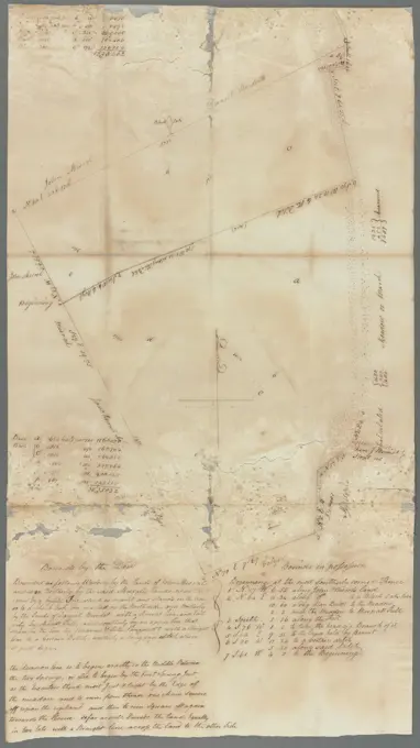
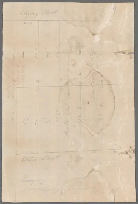
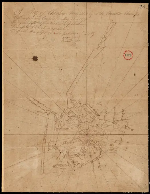
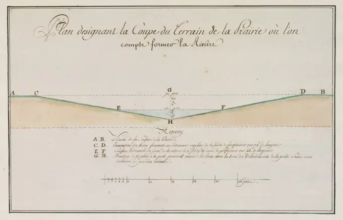
Historical surveys and plans of various towns in 18th-century Massachusetts and Maine, showing land divisions and geographic details.

Plan of Marlborough, made by Andrew Peters, dated November 1794. ,. Massachusetts. Office of the Secretary of State
264 assets in this story
6145-50511306
Plan of Farmington, made by Lemuel Perham, dated May, 1795. ,. Massachusetts. Office of the Secretary of State
6145-54268614
Plan of Farmington, made by Lemuel Perham, dated May, 1795..... , Maine  , Franklin  ,county   , Farmington
6145-50511581
Plan of Oakham, made by Daniel Walker, dated 1794-5. ,. Massachusetts. Office of the Secretary of State
6145-55955755
Dr. Romayne's ground agreeable to the award by rule of court 1799. text. Documents, Surveys, Maps. Manuscripts and Archives Division
6145-55916394
Plan of Princeton, surveyor's name not given, dated May 6, 1795..... , Massachusetts  , Worcester  ,county   , Princeton
6145-48712785
Plan of Biddeford, made by Partridge Richardson, dated 1794. ,. Massachusetts. Office of the Secretary of State
6145-50511635
Plan of Public library lot , Boston Public Library, Maps, Real property, Massachusetts, Boston, Maps, Boston Mass., Maps Norman B. Leventhal Map Center Collection
6145-51386201
Plan of Rowley surveyed by Joseph Chapin, dated December, 1794. ,. Massachusetts. Office of the Secretary of State
6145-50562934
Plan of Sidney surveyed by Sylvester Moore and Ephraim Ballard, dated March 1795. ,. Massachusetts. Office of the Secretary of State
6145-50511940
Plan of Windsor made by Elias J. Baldwin, dated October 1831 ,. Massachusetts. Office of the Secretary of State
6145-59289741
View of Materborn, 1849  Page 69 Recto from a sketchbook with 87 sheets. Materborn paper. pencil  city-view, and landscape with man-made constructions. rural housing, e.g. country-house, villa, cottage Materborn
6145-50570942
Atlas of the city of Chelsea and the towns of Revere & Winthrop, Massachusetts : from actual surveys and official plans. plate 13 , Real property, Massachusetts, Revere, Maps, Landowners, Massachusetts, Revere, Maps, Revere Mass., Maps Norman B. Leventhal Map Center Collection
4443-19590366
A Collection of Surveys of Scottish Estates of the Earl of Selkirk: Kirkeoch; Nun Mill, unknown artist, undated, Graphite, watercolor, gray wash, pen and brown ink on slightly textured, moderately thick, cream wove paper, Sheet: 12 15/16 × 9 1/2 inches (32.9 × 24.1 cm), architectural subject
6145-55956561
Messrs. V.K. Stevenson & Son's new map of New York City / prepared expressly for their Register 1872. Stevenson, V. K.. Cartographic. Maps. Lionel Pincus and Princess Firyal Map Division. Manhattan (New York, N.Y.), New York (N.Y.), Manhattan (New York, N.Y.) , Administrative and political divisions, Buildings , New York (State) , New York (N.Y.), Local transit , New York (State) , New York (N.Y.), Parks , New York (State) , New York (N.Y.), Piers , New York (State) , New York (N.Y.)
6145-52359305
From New York (13) to Poughkeepsie. Colles, Christopher, 1738-1816. Cartographic. Maps, Atlases. 1789. Lionel Pincus and Princess Firyal Map Division. Middle Atlantic States , Road maps , To 1800, United States , Road maps , To 1800
6145-50661537
Map of a plot of arable land and a plot of pasture, located outside the Stadsbuitengracht opposite the Plompetoren in Utrecht; With representation of roads and waterways. With assignment.
6145-48712972
Plan of Lenox, made by Eldad Lewis, dated November 1794. ,. Massachusetts. Office of the Secretary of State
6145-55955119
Six acres of land near Great Kill 1781. Cartographic. Maps, Surveys, land surveys. Manuscripts and Archives Division
6145-55955617
Peter Van Brugh Livingston's estate in Cliff and Broad Streets 1793. Cartographic. Maps, Surveys, land surveys. Manuscripts and Archives Division
6145-54268766
Plan of Montgomery, surveyor's name not given, dated November 1794..... , Massachusetts  , Hampden  ,county   , Montgomery
6145-51386306
Plan of Sutton, made by Ebenzer Waters, dated Novmeber 1794. ,. Massachusetts. Office of the Secretary of State
6145-55955825
Thomas Barns's land Westchester 1787. Cartographic. Maps, Surveys, land surveys. Manuscripts and Archives Division
6145-51397757
Ohio boundary no. 2 : map exhibiting the positions occupied on the Maumee Bay and river: viz: Turtle Island, the North Cape, and that above Toledo, together with the position of the 'east line,' in its passage of the Maumee River surveyed under the direction of Capt. Talcott, U.S. Engineers, by Lieuts. Hood & R.E. Lee , Lucas County Ohio, Maps, Maumee River Ind. and Ohio, Maps, Erie, Lake, Maps, Toledo Ohio, Maps, Michigan, Boundaries, Ohio, Maps, Ohio, Boundaries, Michigan, Maps Norman B. Leventhal Map Center Collection
6145-55955016
Cherry and Water Street 1803. Cartographic. Maps, Surveys, land surveys. Manuscripts and Archives Division
6145-43818356
Plan of No Town (Princeton), surveyor's name not given, dated 1838 ,. Massachusetts. Office of the Secretary of State
6145-54268593
Plan of Egremont made by David Fairchild, dated December, 1794..... , Massachusetts  , Berkshire  ,county   , North Egremont Massachusetts  , Berkshire  ,county   , South Egremont
6145-50536261
1798 Map of Washington ,. Messenger Collection
6145-51939848
Drawing..
6145-52833218
This medium-strong paper drawing by Francesco Borromini shows a partial floor plan of a cathedral in Albano, executed in graphite with sketching and lettering details.
6145-55916231
Plan of Chatham, surveyor's name not given, dated May 22, 1795..... , Massachusetts  , Barnstable  ,county   , Chatham
6145-48712830
Plan of Cutler's Grant (Porter) made by Nathaniel Merrill, dated 1794-1795. ,. Massachusetts. Office of the Secretary of State
6145-48713082
Plan of Paxton surveyed by Ephraim Carruth, dated May 23, 1795. ,. Massachusetts. Office of the Secretary of State
6145-48559616
Plan of Lowell made by John G. Hales, dated 1831 ,. Massachusetts. Office of the Secretary of State
6145-54268759
Plan of Millbury made by Hervey Peirce, dated January 1831.... , Massachusetts  , Worcester  ,county   , Millbury
6145-50511817
Plan of the land at Prince Street and Snowhill Street, Boston , Real property, Massachusetts, Boston, Maps, Landowners, Massachusetts, Boston, Maps, North End Boston, Mass., Maps Norman B. Leventhal Map Center Collection
6145-50568534
Map of Montague Village , Landowners, Massachusetts, Montague, Maps, Real property, Massachusetts, Montague, Maps, Montague Mass., Maps Norman B. Leventhal Map Center Collection
6145-50661504
Map of plots land, located northeast of the Bleekersgracht near the Hofstede Lubbenes in Utrecht; With the designation of already excavated and still to be digged, of land by Van Noordt. With legend.
6145-50562874
Plan of Kingston surveyed by John Gray, dated May 6, 1795. ,. Massachusetts. Office of the Secretary of State
6145-46087545
Design for a necklace. Colored reproduction of design for a necklace.
4443-75475850
Colonel De Lancey's cleared land., 1764-08-19
6145-50511736
Plan of Sudbury, 1707 ,. Wayland Historical Maps and Plans
6145-50562907
Plan of Pittsfield surveyor's name not given, dated December 8, 1794. ,. Massachusetts. Office of the Secretary of State
6145-30322988
Augustus Welby Northmore Pugin, 1812-1852, British, Raglan Castle, Monmouthshire, Wales: Preliminary Plan of Dungeon, undated. Graphite on medium, smooth, cream wove paper.
6145-51386030
Plan of Dorchester made by Mather Withington, dated September, 1794. ,. Massachusetts. Office of the Secretary of State
4443-75458983
Broadway, 1806-02-08
4409-17309409
PLANO PORCION DE MALAGA 1731. Location: SERVICIO GEOGRAFICO DEL EJERCITO. MADRID. SPAIN.
6145-51386131
Plan of Marblehead made by Alfred Ingalls, dated October 1795. ,. Massachusetts. Office of the Secretary of State
6145-55955531
Piece of ground near the stone wall at the Common 1764. text. Documents, Surveys, Maps. Manuscripts and Archives Division
4409-17518074
Legerkampen van de Hollandse en de Franse legers bij Leuven, ca. 1705. Plan van de Hollandsch en fransche Armee soo als de selve tegenwoordig Gecampeert staan by leuve voor de rievier de diele (title on object). Draughtsman: Samuel Du Ry de Champdoré. Dating: 1705. Place: Netherlands. Measurements: h 158 mm × w 200 mm. Museum: Rijksmuseum, Amsterdam.
6145-55917276
Survey plat of land grants on Caps River, Saint Domingue. Title supplied by cataloger. Oriented with north to the bottom. Featured in the Faces & Places Exhibit, Kravis Center, Palm Beach, FL, since 2005.. During the French colonial regime, Saint Domingue became one of the richest European colonies in the West Indies. Like many of the other islands, the economy focused on large sugar plantations, utilizing a sizeable importation of African slaves and taking advantage of fertile soils and an ideal climate. On the eve of the French revolution in 1784, there were approximately a half million slaves, outnumbering the free population 10-1. Life was harsh for the slaves but approximately 30,000 had gained freedom. These freed slaves were often mulattoes (children of French plantation owners and slave women) who had been granted freedom by their masters or black slaves who were able to purchase their freedom. Many of these slaves were able to acquire land, becoming wealthy, as indicated by th
6145-45785757
MONTFERBERG. Paint drawing in black and white from the height of Montferland with the surroundings of arable land, a mill and a road with cart, horse and mens. With inscription. Part from Jan Brandes, DL sketchbook. 2 (1808), p. 34 and see p. 35.
4443-19590369
A Collection of Surveys of Scottish Estates of the Earl of Selkirk: Little Sypeland, unknown artist, undated, Graphite, watercolor, gray wash, pen and blue and black ink on slightly textured, moderately thick, cream wove paper, Sheet: 11 3/4 × 8 3/8 inches (29.8 × 21.3 cm), architectural subject
4443-75462948
A manuscript map titled 'Isaac Watson resurvey, 1724,' depicting the Isaac Watson Plantation in Hamilton Township, New Jersey, near the Delaware River. Created in 1724 by order of James Alexander, the map measures 40 x 45 cm or smaller and is focused on real property and landownership in New Jersey, specifically within the Delaware River Valley area
6145-43818342
Plan of Boston Corner made by Augustus Tremain, dated June 7, 1840 ,. Massachusetts. Office of the Secretary of State
6145-59551441
Scenographia or Perspective leather, Jan Brandes, 1787 - 1808 drawing Handwritten treatise written on two double-folded sheets with pen and brush drawings illustrated, over the perspective doctrine. To an existing book. The text is in Latin with Dutch and Swedish notes. Vissebo paper. ink. pencil pen / brush
6145-30216248
Drawing sketch book: Informations and cow-cow registration and red stamp Sale Corot (Page 1) Camille-Jean-Baptiste Corot (1796-1875). Drawings Sketch Book: Informations and Cow-Cow Registration and Red Stamp Sale Corot (page 1). Pencil.
6145-48713247
Plan of Ward (Auburn) made by Hervey Peirce, dated February 1831 ,. Massachusetts. Office of the Secretary of State
4409-17933184
PLANO DE LA COSTA DE MURCIA - SIGLO XVIII. Location: ARCHIVO-COLECCION. Simancas. Valladolid. SPAIN.
6145-55955245
Greenwich - Foxcraft 1780 - 1810. Cartographic. Maps, Surveys, land surveys. Manuscripts and Archives Division
6145-48713201
Plan of Wales surveyed by James Shurtleff, dated 1794. ,. Massachusetts. Office of the Secretary of State
6145-54548999
Map of the Hudson ... from New York Harbor the Fort Washington. Bridges. Cartographic. Atlases, Maps. 1820. Lionel Pincus and Princess Firyal Map Division. New York (N.Y.), New Jersey, Hudson River (N.Y. and N.J.) , Maps, Hudson River Valley (N.Y. and N.J.) , Maps, Post roads , New York (State)
6145-59603900
Map of the Schieland Water Board, Decorative Cartouche, Floris Balthasarsz. Van Berckenrode, 1611 - 1635 print   paper etching / engraving maps of separate countries or regions. armorial bearing, heraldry Schieland
6145-48717948
Profile of a proposed route for a canal between Buzzards and Barnstable Bays , Canals, Massachusetts, Cape Cod, Maps, Cape Cod Canal Mass., Maps Norman B. Leventhal Map Center Collection
6145-52821473
Ink, feather, and watercolor plan by Herzog Albert von Sachsen-Teschen depicting the cup of prairie land for a planned river around 1782, showing topography and landform layout.
PREVIOUS
of 3
NEXT
2401 S. Ervay, Suite 206
Dallas, Texas 75215
United States
Get Started
Free ResearchMy BoardsMy Cart
For Creators
How To License Your ContentContributor PortalFrame of Mind
Resources
API accessPricing
Contact
+1 866 236 0087help@viewpictures.co.uk Contact form
©2026 View Pictures. All Rights Reserved. -B
This site is protected by reCAPTCHA and Google Privacy Policy and Terms of Service apply.