My Boards
View Pictures
  • My Boards

Earth Observations from Space

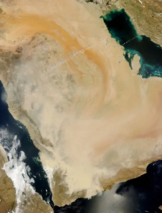
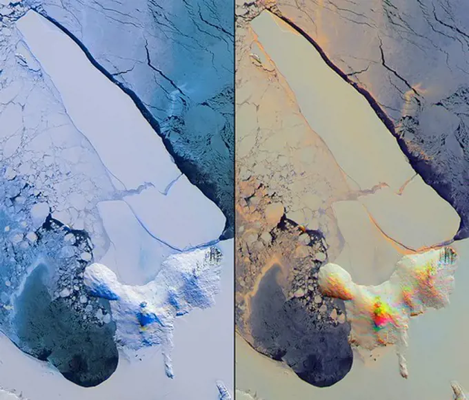
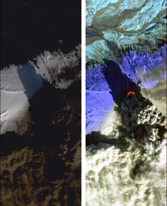
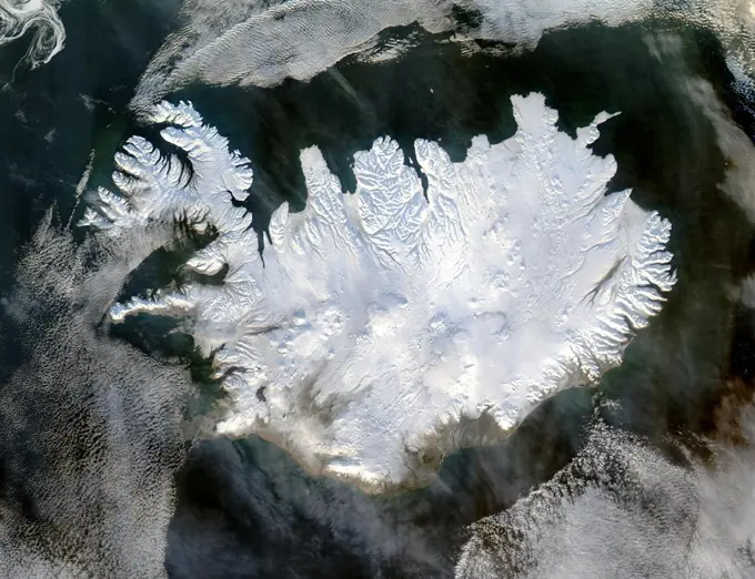
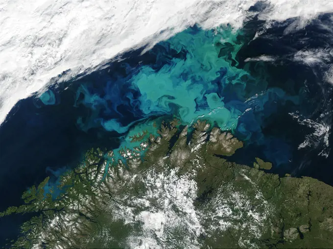
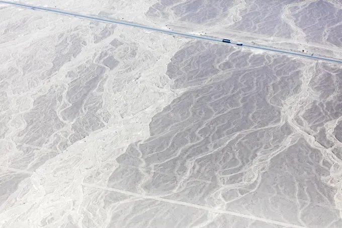
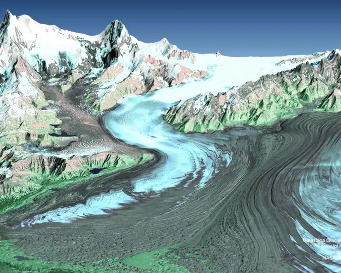
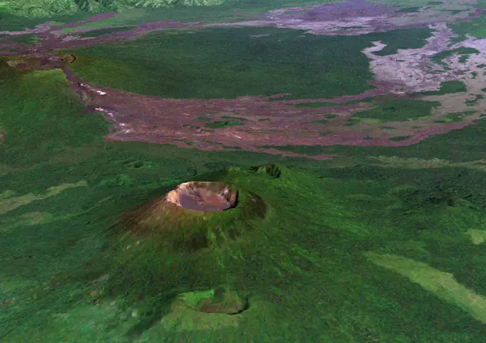
Aerial imagery from the International Space Station showcasing varied landscapes, including mountains, rivers, and urban areas.

iss061e048086 (Nov. 19, 2019) --- The Andes mountain range that separates the arid and sub-tropical climates in northern Argentina is pictured as the International Space Station orbits from an altitude of 260 miles.
383 assets in this story
6145-44913197
ISS033-E-014658 (21 Oct. 2012) --- This photograph of Bhutan, taken by one of the Expedition 33 crew members aboard the International Space Station, shows a number of Himalayan peaks, glaciers and lakes.  The space station was flying over a nadir point located at 28.3 degrees north latitude and 92.1 degrees east longitude when the image was recorded.
6145-44938378
Earth Observations taken by Expedition 34 crewmember.
6145-45101318
ISS046e004756 (01/04/2016) --- NASA astronaut Scott Kelly captured this beige desert image as the International Space Station passed over Africa. He tweeted out this message: " I can always count on #Africa for colorful #EarthArt. #YearInSpace".
1899-21289912
Satellite view of Najran University, Saudi Arabia. This image was taken in 2014 by Landsat 8 satellite.
6145-44773806
S127-E-006561 (17 July 2009) -- The Nile Riverand its delta in Egypt and the Sinai Peninsula and part of the Mediterranean Sea and Red Seaare just a few of the geographic features recognizable in this photograph, taken from an aft window on the Earth-orbiting Space Shuttle Endeavour.
6145-45287171
iss064e026424 (Jan. 25, 2021) --- Mount Taranaki on the island nation of New Zealand is pictured from the International Space Station as it orbited 268 miles above the South Pacific.
6145-45051288
Earth observation taken by the Expedition 39 crew aboard the ISS. Image was released by astronaut on Twitter and downlinked in folder Houston.
6145-45256872
The voyage of Iceberg B-31 continued in January, 2014 as the giant iceberg drifted over the frigid waters of Pine Island Bay and widened the gap between the newly-calved iceberg and the mother” glacier. Between November 9 and 11, 20143 a giant crack in the Pine Island Glacier gave completely away, liberating Iceberg B-31 from the end of the glacial tongue. The new iceberg was estimated to be 35 km by 20 km (21 mi by 12 mi) in size - or roughly the size of Singapore. On January 5, 2014 the Moderate Resolution Imaging Spectroradiometer (MODIS) aboard NASA’s Terra satellite captured this true-color image of B-31 floating in the center of Pine Island Bay on an approach to the Amundsen Sea. Pine Island Glacier can be seen on the upper right coast of the bay, and is marked by parallel lines in the ice. According to measurements reported by the National U.S. Ice Center, on January 10, B-31 was maintaining its size, and was located at 74°24'S and 104°33'W.
6145-30235229
Scott Base, the New Zealand research station in the Antarctic, as seen on November 12, 2016, as U.S. Secretary of State John Kerry visited neighboring McMurdo Station and other U.S. research facilities around Ross Island and the Ross Sea in an effort to learn about the effects of climate change on the Continent.
6145-44825249
ISS024-E-008396 (15 July 2010) --- Sabancaya volcano in Peru is featured in this image photographed by an Expedition 24 crew member on the International Space Station. The 5,967-meter-high Sabancaya stratovolcano (or Nevado Sabancaya) is located in southern Peru approximately 70 kilometers to the northwest of the city of Arequipa. The name Sabancaya means tongue of fire in the Quechua Indian language. Sabancaya is part of a volcanic complex that includes two other nearby (and older) volcanoes, neither of which has been active historically; in this detailed photograph, Nevado Ampato is visible to the south (top center) and the lower flanks of Nevado Hualca Hualca are visible to the north (bottom right). The snowy peaks of the three volcanoes provide a stark contrast to the surrounding desert of the Puna Plateau. Sabancayas first historical record of an eruption dates to 1750. The most recent eruptive activity at the volcano occurred in July 2003 and deposited ash on the volcanos sum
4389-152
Afghanistan Dust Storm From Space Shuttle Atlantis in Earth Orbit
6145-44484942
The eruption of the Fagradalsfjall volcano in southwest Iceland continued two weeks after it started, along a fissure spewing lava fountains and producing flows. The ASTER visible-near infrared image (left) shows the black fresh lava, and a small bright red area of incandescent lava. A thin gray eruption plume streams to the southeast. The color-coded thermal infrared image (right) highlights the hottest areas of activity in red, and then in bright shades of red. The image was acquired August 15, 2022, covers an area of 14.6 by 15.7 km, and is located at 64.2 degrees north, 21.1 degrees west.
6145-44966829
Earth observation taken during a day pass by an Expedition 36 crew member on board the International Space Station (ISS).
1899-53518348
Color satellite image of Upsala Glacier in Argentinas Los Glaciares National Park in 2001 and 2021. It has experienced significant retreat over the past century. Its melting indicates climate warming in this part of South America.
1746-19663359
A dense wall of dust barrelled across the Arabian Peninsula on March 26-27, 2011. The massive storm stretches more than 500 kilometres (300 miles) across the peninsula, covering parts of Saudi Arabia, Yemen, Oman, and the United Arab Emirates.
4389-1151
Breakup of the World's Largest Iceberg
6145-44843140
ISS026-E-017074 (11 Jan. 2011) --- Emi Koussi volcano in Chad is featured in this image photographed by an Expedition 26 crew member on the International Space Station. The large Emi Koussi volcano is located in northern Chad at the southeastern end of the Tibesti Range. The dark volcanic rocks of the volcano provide a sharp contrast to the underlying tan and light brown sandstones exposed to the west, south, and east. Emi Koussi is a shield volcano formed from relatively low viscosity lavasflowing more like motor oil as opposed to toothpasteand explosively-erupted ignimbrites that produce a characteristic low and broad structure that covers a wide area (approximately 60 x 80 kilometers). This photograph highlights the entire volcanic structure; at 3,415 meters above sea level, Emi Koussi is the highest summit of the Sahara region. The summit area contains three calderas formed by powerful eruptions. Two older, and overlapping, calderas form a depression approximately 12 x 15 kilomet
6145-54676656
. iss068e036382 (Jan. 2, 2023) - A portion of the Atlantic Ocean surrounded by the island nation of the Bahamas is pictured from the International Space Station as it orbited 259 miles above.
1899-53518375
Color satellite image of Shanghai, China in 1987.
6145-45257640
This nearly cloud-free image of Iceland was captured by the MODIS instrument on board the Terra spacecraft on 04/15/2015 at 13 00 UTC. b a href= http //www.nasa.gov/audience/formedia/features/MP_Photo_Guidelines.html rel= nofollow NASA image use policy. /a /b b a href= http //www.nasa.gov/centers/goddard/home/index.html rel= nofollow NASA Goddard Space Flight Center /a /b enables NASAs mission through four scientific endeavors Earth Science, Heliophysics, Solar System Exploration, and Astrophysics. Goddard plays a leading role in NASAs accomplishments by contributing compelling scientific knowledge to advance the Agencys mission. b Follow us on a href= http //twitter.com/NASAGoddardPix rel= nofollow Twitter /a /b b Like us on a href= http //www.facebook.com/pages/Greenbelt-MD/NASA-Goddard/395013845897 ref=tsd rel= nofollow Facebook /a /b b Find us on a href= http //instagrid.me/nasagoddard/ vm=grid rel= nofollow Instagram /a /b
1746-19663290
On Sat., April 17, 2010, the Hyperion instrument on-board NASAs Earth Observing-1 (EO-1) spacecraft obtained this pair of images of the continuing eruption of Icelands Eyjafjallajökull volcano. In the left-hand image, created from visible wavelengths, new black ash deposits are visible on the ground, as well as nearby brilliant unsullied ice and snow and the volcanos brown, billowing plume. The plumes dark colour reflects its large ash content. These fine particles of pulverized rock are carried high into the atmosphere, where they create a hazard for aviation and are carried long distances by the prevailing winds. In contrast, the false-colour, infrared image at the right reveals the intense thermal emissions (at least 60 megawatts, or 60 million watts) emanating from the vent at the base of the massive plume. This thermal emission, equivalent to the energy consumption of 60,000 homes, represents only a small proportion of the total energy being released by the volcano as its molt
6145-44849177
NASA image acquired February 25, 2011 Pyroclastic flows are some of the most fearsome hazards posed by erupting volcanoes. These avalanches of superheated ash, gas, and rock are responsible for some of the most famous volcanic disasters in history, including the burial of the ancient Roman city of Pompei and the destruction of Saint-Pierre in 1902. More recently, pyroclastic flows from Mount Merapi in Indonesia caused most of the casualties during the volcanos 2010 eruption. The intense heat—over 1,000° Celsius (1800° Fahrenheit)—the terrific speed—up to 720 kilometers (450 miles) per hour—and the mixture of toxic gases all contribute to the deadly potential. Pyroclastic flows can incinerate, burn, or asphyxiate people who cannot get out of the flow path. This false-color satellite image from the Advanced Spaceborne Thermal Emission and Reflection Radiometer (ASTER) on the Terra satellite shows the remnants of a large pyroclastic flow on the slopes of Shiveluch Volcano. Fortunately, n
1899-21290445
Satellite view of Abu Dhabi, United Arab Emirates in 1985 and 2014. This before and after image shows urban expansion over the years.
6145-45118209
At the southern end of the Earth, a NASA plane carrying a team of scientists and a sophisticated instrument suite to study ice is returning to surveying Antarctica. For the past eight years, Operation IceBridge has been on a mission to build a record of how polar ice is evolving in a changing environment. The information IceBridge has gathered in the Antarctic, which includes data on the thickness and shape of snow and ice, as well as the topography of the land and ocean floor beneath the ocean and the ice, has allowed scientists to determine that the West Antarctic Ice Sheet may be in irreversible decline. Researchers have also used IceBridge data to evaluate climate models of Antarctica and map the bedrock underneath Antarctic ice. Read more http //go.nasa.gov/2dxczkd b a href= http //www.nasa.gov/audience/formedia/features/MP_Photo_Guidelines.html rel= nofollow NASA image use policy. /a /b b a href= http //www.nasa.gov/centers/goddard/home/index.html rel= nofollow NASA Goddard Space
6145-45066456
Earth Observation taken during a day pass by the Expedition 40 crew aboard the International Space Station (ISS). Folder lists this as Sahara.
6145-44583630
ISS005-E-19024 (30 October 2002) ---  The three-member crew of the Expedition Five  mission onboard the International Space Station was able to observe Mt. Etna’s spectacular eruption, and photograph the details of the eruption plume and smoke from fires triggered by the lava as it flowed down the 11,000 ft mountain.  This image and a second image (ISS005-E-19016) are looking obliquely to the southeast over the island of Sicily.  The wider view (ISS005-E-19024) shows the ash plume curving out toward the horizon, caught first by low-level winds blowing to the southeast, and to the south toward Africa at higher altitudes.  Ashfall was reported in Libya, more than 350  miles away.  The lighter-colored plumes downslope and north of the summit seen in this frame are produced by forest fires set by lava flowing into the pine forests on the slope of the mountain.   This image provides a more three-dimensional profile of the eruption plume.  This eruption was one of Etna’s most vig
6145-44921865
Earth Observations taken by Expedition 34 crewmember.
6145-45259727
When NASA's Terra satellite flew over the Puyehue-Cordon Caulle volcano on July 8, 2011 at 14 25 UTC (10 25 a.m. EDT) it captured this visible image of a steady stream of ash (light brown) blowing southeast into Argentina. The Puyehue-Cordón Caulle Volcano is located in the Andes Mountains of central Chile, near the Argentina border. Image NASA Goddard/MODIS Rapid Response Team, Jeff Schmaltz Text NASA Goddard/Rob Gutro b a href= http //www.nasa.gov/centers/goddard/home/index.html rel= nofollow NASA Goddard Space Flight Center /a /b enables NASAs mission through four scientific endeavors Earth Science, Heliophysics, Solar System Exploration, and Astrophysics. Goddard plays a leading role in NASAs accomplishments by contributing compelling scientific knowledge to advance the Agencys mission. b Follow us on a href= http //twitter.com/NASA_GoddardPix rel= nofollow Twitter /a /b b Like us on a href= http //www.facebook.com/pages/Greenbelt-MD/NASA-Goddard/395013845897 ref=tsd rel= nofoll
1899-53518403
Color satellite image of Columbia glacier in 1986 and 2022.
6145-58971464
iss070e008930 (Oct. 24, 2023) --- A wildfire in Western Australia's Forest Grove National Park, with smoke billowing out into the Indian Ocean, is pictured from the International Space Station as it orbited 266 miles above.
1746-19661422
Satellite image of Iceland on 28 January 2004 showing it covered in a blanket of snow and ice which is obscuring the permanent glaciers and icecaps that exist year-round. Credit NASA. Science Winter
1746-28998685
Retreat of Alaskas Columbia Glacier; Satellite image shows the state of glacier melting in 2000
6145-44471857
Artemis I will be the first integrated flight test of NASAs deep space exploration system: the Orion spacecraft, Space Launch System (SLS) rocket and the ground systems at Kennedy Space Center in Cape Canaveral, Florida. The first in a series of increasingly complex missions, Artemis I will be an uncrewed flight that will provide a foundation for human deep space exploration, and demonstrate our commitment and capability to extend human existence to the Moon and beyond. During this flight, the uncrewed Orion spacecraft will launch on the most powerful rocket in the world and travel thousands of miles beyond the Moon, farther than any spacecraft built for humans has ever flown, over the course of about a three-week mission.
1899-53517865
Color satellite image of Finland and neighbouring countries.
6145-44679938
ISS015-E-17020 (7 July 2007) --- Mount Rainier in Washington is featured in this image photographed by an Expedition 15 crewmember on the International Space Station.
1899-18415848
Color satellite image of wildfires in Santa Barbara County, California, United States. Image collected on December 18, 2017 by Sentinel-2 satellites.
6145-45128981
This false-color scene from NASA's Mars Exploration Rover Opportunity documents movement of dust as a regional dust storm approached the rover's location on Feb. 24, 2017.
1746-28998686
Retreat of Alaskas Columbia Glacier; Satellite image shows the state of glacier melting in 2001
1899-53518402
Color satellite image of Columbia glacier in 2022.
6145-44943582
Earth Observations taken by Expedition 34 crewmember.
6145-45135707
This graphic shows the route that NASA's Mars Exploration Rover Opportunity drove in its final approach to 'Perseverance Valley' on the western rim of Endeavour Crater.
6145-45068576
ISS040-E-089782 (8 Aug. 2014) --- The Georges Lemaitre” Automated Transfer Vehicle (ATV-5), photographed by an Expedition 40 crew member, flies directly under the International Space Station at a distance of about 3.7 miles to test sensors and radar systems designed for future European spacecraft. After its fly-under” of the station, the ATV will move in front of, above, and behind the outpost for the final days of its two-week rendezvous that will lead to an automated docking to the aft port of the Zvezda Service Module on Aug. 12.
6145-44485332
The hot and arid desert geography of Kerman Province in central Iran is pictured from the International Space Station as it orbited 258 miles above.
6145-44935554
Earth Observations taken by Expedition 34 crewmember.
6145-44717541
S71-33432 (1 July 1971) --- These alternative traverses can be carried out on foot. They will be used if the Lunar Roving Vehicle (LRV) becomes inoperative. This artist's concept showing part of the Hadley Rille and several of the Apennine Mountains was excerpted from On the Moon with Apollo 15 A Guidebook to the Hadley-Apennine Region, by Gene Simmons. Artwork by Jerry Elmore.
6145-45112402
This image, captured by NASA's Terra spacecraft on July 27, 2016m shows the Lava Mountain fire in Wyoming where several small towns have been evacuated.
1525-57473554
Himalayas, North India. Elements of this image furnished by NASA. 3d rendering. Himalayas, North India
6145-44816787
ISS023-E-027737 (23 April 2010) --- Nevado del Ruiz volcano in Colombia is featured in this image photographed by an Expedition 23 crew member on the International Space Station. The large Nevado del Ruiz volcano (center) is located approximately 140 kilometers to the northwest of the capital city of Bogota and covers an area of over 200 square kilometers. Nevado del Ruiz is a stratovolcano - a type of volcano built from successive layers of lava, ash, and pyroclastic flow deposits - formed by magma generated above the boundary between the subducting Nazca and overriding South American tectonic plates. The historical record of eruptions extends back to 1570, but the most damaging eruption in recent times took place in 1985. On Nov. 13, 1985, an explosive eruption at the Arenas Crater (center) melted ice and snow at the summit of the volcano. This lead to the formation of mudflows (or lahars) that swept tens of kilometers down river valleys along the volcanos flanks, resulting in the d
1746-19662329
Barents Sea  July 19th, 2003, as seen by MODIS. Image courtesy of Jacques Descloitres, MODIS Land Rapid Response Team at NASA GSFC.
6145-52577392
Oil and gas explorations from winter 1972-1973. Subjects: Industries; Oil Exploratioin; Selawik National Wildlife Life Refuge; Alaska.
6145-45104472
In Dec. 2015, one of Nicaragua's largest volcanoes, Momotombo, erupted for the first time since 1905. NASA's Terra spacecraft acquired this image showing large ash columns and pyroclasitc flows.
6188-55455917
Nazca lines from the aircraft Mysterious figures Nazca desert from the aircraft Copyright: xZoonar.com/MassimoxLamax 11537355
1899-53518343
Color satellite image of Malaspina Glacier, Alaska in 1986 and 2022, showing how the glacier has been melting over the years.
6145-44943578
Earth Observations taken by Expedition 34 crewmember.
6145-45232153
NASA image acquired December 23, 2011 In early June 2011, Chiles Puyehue-Cordón Caulle Volcano erupted explosively, sending volcanic ash around the Southern Hemisphere. In late December 2011, activity at the volcano had calmed, but volcanic ash and steam continued to pour through the fissure that opened several months earlier. The Advanced Land Imager (ALI) on NASAs Earth Observing-1 (EO-1) satellite captured this natural-color image on December 23, 2011. The active fissure lies northwest of the Puyehue caldera, and a plume blows from the fissure toward the west and north. This image shows not just ash but also snow on the volcano surface, including the caldera. Because volcanic ash regularly coats the land surface, the pristine snow probably fell recently. In a bulletin issued December 26, 2011, Chiles Servicio Nacional de Geología y Minería (SERNAGEOMIN) characterized the activity over the previous 24 hours as a minor eruption of low intensity. Reaching an altitude of 2,236 meters
1746-28998662
Continental ice sheet. Antarctica in 1996, showing the Antarctic ice sheet.
6145-45059667
ISS040-E-007404 (4 June 2014) --- One of the Expedition 40 crew members aboard the International Space Station on June 4, 2014, recorded this vertical image of Fangataufa Atoll, a small coral atoll on the eastern side of the Tuamotu Archipelago in French Polynesia in the South Pacific Ocean.
6145-45264064
The Advanced Spaceborne Thermal Emission and Reflection (ASTER) instrument onboard NASA's Terra spacecraft obtained near-infrared data of the ongoing Kilauea volcano eruption and its impact on the Leilani Estates area on May 15, 2018 (left) and June 23, 2018 (right). The current eruption began May 3. Red areas are vegetated, while white areas are clouds or volcanic plumes. The new dark areas show where the ground has been covered with lava flows. The lava seen here, flowing a high rate of volume from a vent designated Fissure 8, flowed eastward to the coast. In early June 2018, these rapidly moving flows destroying hundreds of homes in and around the towns of Vacationland and Kapoho, and filled in Kapoho Bay. The flows are now creating a new broad delta, extending the island of Hawaii. A plume has formed where incandescent lava flows into the Pacific. In the ASTER observation obtained on June 23, a well-developed leveed and perched lava channel flowing from left to right is clearly see
1899-53518409
Color satellite image of Koufra oasis in 1984 and 2022.
1746-19663856
The tongue of the Malaspina Glacier, the one of the largest glaciers in Alaska, fills most of this image. The Malaspina lies west of Yakutat Bay and covers roughly 1,500 sq. mi (3,880 sq. km).This image was acquired by Landsat 7s Enhanced Thematic Mapper plus (ETM+) sensor on August 31, 2000. This is a false-colour composite image made using infrared, near infrared, and green wavelengths
6145-44844463
NASA image acquired January 22, 2011 To view the full image go to a href= http //www.flickr.com/photos/gsfc/5397636843 www.flickr.com/photos/gsfc/5397636843 /a Every southern spring and summer, after the Sun has risen into its 24-hour circuit around the skies of Antarctica, the Ross Sea bursts with life. Floating, microscopic plants, known as phytoplankton, soak up the sunlight and the nutrients stirring in the Southern Ocean and grow into prodigious blooms. Those blooms become a great banquet for krill, fish, penguins, whales, and other marine species who carve out a living in the cool waters of the far south. This true-color image captures such a bloom in the Ross Sea on January 22, 2011, as viewed by the Moderate Resolution Imaging Spectroradiometer (MODIS) on NASAs Aqua satellite. Bright greens of plant-life have replaced the deep blues of open ocean water. The Ross Sea is a relatively shallow bay in the Antarctic coastline and due south from New Zealand. As the spring weather tha
1899-34931
Volcano Nyiragongo In 3D, Democratic Republic Of Congo, True Colour Satellite Image. Nyiragongo, Congo, true colour satellite image. Nyiragongo is one of Africa's most active volcano, located 10km from the town of Goma. Image taken on 11 December 2001 using LANDSAT data.
6145-45098744
ISS045E034631 (09/28/2015) --- The Japan Aerospace Exploration Agency (JAXA) Kounotori 5 H-II Transfer Vehicle (HTV-5) is seen departing from the International Space Station. The cargo vehicle was berthed to the orbiting laboratory for five weeks until it was released on Sept. 28, 2015. HTV-5 delivered almost five tons of hardware and supplies.
1746-30004396
Photograph of the Arctic sea ice during the summer of 2015. The gold line indicates that it has shrunk since 1981-2010.
6145-44856598
ISS027-E-009771 (2 April 2011) --- Bassas da India is featured in this image photographed by an Expedition 27 crew member on the International Space Station. The vantage point of crew members onboard the space station provides many dramatic views of Earths surface. This detailed photograph of the Bassas da India, an uninhabited atoll in the Indian Ocean (between the Mozambique coast of Africa and the island of Madagascar) has an almost surreal quality due to varying degrees of sunglint. Sunglint is an optical phenomena caused by light reflecting off of a water surface directly back towards the observer. Variations in the roughness of the water surfacepresence or absence of waves due to wind and water currentswill cause differences in the intensity of the sunglint. The presence of other materials, such as oils or surfactants, can also change the properties of the water surface. Here the presence of currents is highlighted as darker patches or streaks (left and upper right). In contra
6145-52138324
An overview of the landscape during Operation Deep Freeze '82. Subject Operation/Series: DEEP FREEZE '92 Country: Antarctica(ATA)
6145-44483652
This annotated overhead image from the HiRISE camera aboard NASA's Mars Reconnaissance Orbiter (MRO) depicts three options for the agency's Mars Ingenuity Helicopter to take on flights out of the Séítah region, as well as the location of the entry, descent, and landing (EDL) hardware. The size and location of the landing ellipses have been analyzed to be safe for landing - free of hazards such as rocks, dunes, and large slopes. See an interactive map with Perseverance and Ingenuity location updates here
1746-19659484
Antarctica. photographed by satellite MODIS observations of polar sea ice and combined with observations by the National Oceanic and Atmospheric Administrations AVHRR sensor—the Advanced Very High Resolution Radiometer. 2006
6145-58971647
iss070e033932 (Nov. 29, 2023) --- Wildfires in northern California's Humboldt County off the coast of the Pacific Ocean are pictured from the International Space Station as it orbited 261 miles above.
4389-2385
Melt Zones in Greenland
6145-45287176
iss064e026165 (Jan. 26, 2021) --- The Republic of China's Dongsha Atoll National Park is pictured from the International Space Station as it orbited 261 miles above the South China Sea.
6145-44967100
NASA's Terra spacecraft passed over the Silver Fire in western New Mexico on June 7, 2013. It has since consumed more than 137,000 acres of timber in a rugged area of the Gila National Forest that has not seen large fires for nearly a century.
6145-44519014
James Bay lies at the southern end of Hudson Bay. Visible in these images captured by NASA's Terra satellite on Aug 9, 2000 and Jan. 15, 2001, are some of the many rivers that flow into the bay.
6145-45258404
This image taken on January 13, 2015 from the Suomi NPP satellite's VIIRS instrument shows the Great Lakes and surrounding areas. The latest Great Lakes Surface Environmental Analysis (GLSEA) from the NOAA Great Lakes Environmental Research Laboratory shows total ice cover of 29.3% as of January 13th.
6145-44844464
NASA image acquired January 22, 2011 Every southern spring and summer, after the Sun has risen into its 24-hour circuit around the skies of Antarctica, the Ross Sea bursts with life. Floating, microscopic plants, known as phytoplankton, soak up the sunlight and the nutrients stirring in the Southern Ocean and grow into prodigious blooms. Those blooms become a great banquet for krill, fish, penguins, whales, and other marine species who carve out a living in the cool waters of the far south. This true-color image captures such a bloom in the Ross Sea on January 22, 2011, as viewed by the Moderate Resolution Imaging Spectroradiometer (MODIS) on NASAs Aqua satellite. Bright greens of plant-life have replaced the deep blues of open ocean water. The Ross Sea is a relatively shallow bay in the Antarctic coastline and due south from New Zealand. As the spring weather thaws the sea ice around Antarctica, areas of open water surrounded by ice—polynyas—open up on the continental shelf. In this
1899-34925
Volcano Damavand In 3D, Iran, True Colour Satellite Image. Volcano Damavand, Iran. Damavand is a large dormant volcano, the highest point in Iran with 5671m, in the centre of the Elburz mountains. Image taken on 19 September 1988 using LANDSAT data.
6145-52960828
. Hunga Tonga-Hunga Ha'apai Eruption. The eruption of Hunga Tonga-Hunga Ha'apai in 2022 produced a plume 58 km high, and produced the biggest atmospheric explosion ever recorded. At least six people lost their lives in the ensuing tsunami. The two small islands are all that is left visible of a huge underwater volcano. The image covers an area of 4.6 by 4.6 km, was acquired September 7, 2022, and is located at 20.5 degrees south, 175.4 degrees west.
6145-44841788
The red line on this map shows where NASA's Mars Rover Opportunity has driven from the place where it landed in January 2004, inside Eagle Crater, at the upper left end of the track, to where it reached on Nov. 30, 2010.
4239R-20480123
MODIS (Moderate-resolution Imaging Spectroradiometer) Snow, Sea, Ice.
4220-20400407
Illustration showing the route taken by Roald Amundsen's Antarctic Expedition of 1910-12, from their base at 'Framheim' on the Ross Sea to the South Pole in 1911.     Date: 1912
6145-44679173
Opportunity Gets Ready to Roll
6145-44516371
The contrast between summer and winter is apparent in this pair of images of southwestern Ireland acquired by NASA's Terra satellite August 23, 2000 (left) and December 29, 2000 (right).
4401R-6893
Environmental research, the Antarctic.
PREVIOUS
of 4
NEXT
2401 S. Ervay, Suite 206
Dallas, Texas 75215
United States
Get Started
Free ResearchMy BoardsMy Cart
For Creators
How To License Your ContentContributor PortalFrame of Mind
Resources
API accessPricing
Contact
+1 866 236 0087help@viewpictures.co.uk Contact form
©2026 View Pictures. All Rights Reserved. -A
This site is protected by reCAPTCHA and Google Privacy Policy and Terms of Service apply.