My Boards
View Pictures
  • My Boards

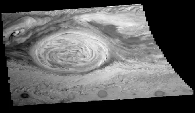
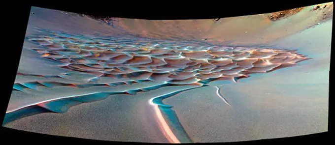
False Color Mars Images

NASA's images showcasing Martian terrain captured in false color, revealing diverse geological features and landscapes on Mars.

Ares Vallis/Iani Chaos Border
392 assets in this story
6145-44624840
This 360-degree view combines frames taken by the navigation camera on NASA's Mars Exploration Rover Spirit during the rover's 271st martian day, or sol, on Oct. 7, 2004. 3D glasses are necessary to view this image.
6145-45265661
Today's image shows part of the floor of Pasteur Crater. The deposit in the southwest part of the floor is a fill deposit that is undergoing erosion. Small sand dunes are found within the eroding material. Pasteur Crater is located between Arabia Terra and Terra Sabaea. The THEMIS VIS camera contains 5 filters. The data from different filters can be combined in multiple ways to create a false color image. These false color images may reveal subtle variations of the surface not easily identified in a single band image. Orbit Number 60913 Latitude 19.5741 Longitude 24.3467 Instrument VIS Captured 2015-09-07 08 02
6145-45105712
The map is a Mercator projection and has a resolution of 460 feet (140 meters) per pixel. The images used to make this map were taken from Dawn's high-altitude mapping orbit (HAMO), at a distance of 915 miles (1,470 kilometers) from Ceres.
6145-58972000
The THEMIS VIS camera contains 5 filters. The data from different filters can be combined in multiple ways to create a false color image. These false color images may reveal subtle variations of the surface not easily identified in a single band image. Today's false color image shows dunes in several craters in Noachis Terra. As with other craters in this region, large mounds of sand dunes are located on the crater floors. Wind directions that blow from east south east to west north west (lower right corner to upper left corner of the image) are arising from Hellas Planitia. Orbit Number 67462 Latitude -48.7336 Longitude 34.0451 Instrument VIS Captured 2017-02-27 18 15
6145-45260364
This pair of images from the Mast Camera (Mastcam) on NASA's Curiosity rover illustrates how special filters are used to scout terrain ahead for variations in the local bedrock. The upper panorama is in the Mastcam's usual full color, for comparison. The lower panorama of the same scene, in false color, combines three exposures taken through different science filters, each selecting for a narrow band of wavelengths. Filters and image processing steps were selected to make stronger signatures of hematite, an iron-oxide mineral, evident as purple. Hematite is of interest in this area of Mars -- partway up Vera Rubin Ridge on lower Mount Sharp -- as holding clues about ancient environmental conditions under which that mineral originated. In this pair of panoramas, the strongest indications of hematite appear related to areas where the bedrock is broken up. With information from this Mastcam reconnaissance, the rover team selected destinations in the scene for close-up investigations to ga
6145-44484448
The THEMIS VIS camera contains 5 filters. The data from different filters can be combined in multiple ways to create a false color image. These false color images may reveal subtle variations of the surface not easily identified in a single band image. Today's false color image shows an unnamed crater in Arabia Terra. Arabia Terra is one of the oldest surface regions on Mars and contains a large variety of surface features. The region is dissected with numerous unnamed channels of all sizes and complexities, as well as numerous pits of unknown origin. The blue features on the crater floor are sand dunes, in this false color combination blue indicates basaltic sands. The THEMIS VIS camera is capable of capturing color images of the Martian surface using five different color filters. In this mode of operation, the spatial resolution and coverage of the image must be reduced to accommodate the additional data volume produced from using multiple filters. To make a color image, three of the
6145-45093352
The THEMIS VIS camera contains 5 filters. The data from different filters can be combined in multiple ways to create a false color image. This image from NASA's 2001 Mars Odyssey spacecraft shows the margin of the polar cap in Promethei Chasma.
6145-45009627
An outcrop informally named 'Chester Lake' is the second rock on the rim of Endeavour crater to be approached by NASA's Mars Exploration Rover Opportunity for close inspection. Chester Lake is about 3 feet (1 meter) across.
6145-44565094
Scamander Vallis
6145-52961066
. Sirenum Fossae - False Color. The THEMIS VIS camera contains 5 filters. The data from different filters can be combined in multiple ways to create a false color image. These false color images may reveal subtle variations of the surface not easily identified in a single band image. Today's false color image shows part of Sirenum Fossae. The linear depressions in this VIS image are tectonic graben. Graben are formed by extension of the crust and faulting. When large amounts of pressure or tension are applied to rocks on timescales that are fast enough that the rock cannot respond by deforming, the rock breaks along faults. In the case of a graben, two parallel faults are formed by extension of the crust and the rock in between the faults drops downward into the space created by the extension. Several graben are visible in this THEMIS VIS image, trending from north-northeast to south-southwest. Because the faults defining the graben are formed perpendicular to the direction of the appl
6145-45265928
This VIS image shows part of the southern cliff face of Ius Chasma. The THEMIS VIS camera contains 5 filters. The data from different filters can be combined in multiple ways to create a false color image. These false color images may reveal subtle variations of the surface not easily identified in a single band image. Orbit Number 61753 Latitude -7.27471 Longitude 274.245 Instrument VIS Captured 2015-11-15 12 03
6145-45297961
This false color image shows part of Harris crater (center of image) and an unnamed crater (top of image). These craters are located north of Hellas Planitia. At the upper right part of the Harris Crater rim, there is a fan shaped form. Fans can be created by different processes. Delta deposit fans are created under water, when a river flow slows down and drops sediments from the water column. These sediments are typically fine grained silts. Deltas form over time and can take many shapes as the river changes channels. The Mississippi River delta is formed this way. Alluvial fans are created in dry climates with short fluid seasons. In this case a single stream hits a topographic opening (think ravine) and sheds the rocks and sand down hill. The alluvial fan shape is created from the single opening. Either way, fans form by the action of a fluid. The THEMIS VIS camera contains 5 filters. The data from different filters can be combined in multiple ways to create a false color image. The
6145-45019580
Dominici and Homer - in Color!
6145-44897893
Ghost in the Darkness
1746-19671111
At the center of this view of an area of mid-latitude northern Mars, a fresh crater about 6 meters in diameter holds an exposure of bright material, blue in this false-color image. HiRISE.
6145-45266168
Today's false color image shows an unnamed crater in Acidalia Planitia. The dark blue feature on the crater floor is a mound of sand. The sand is tall enough to cast a shadow, with the sun is coming from the left (west). The texture on the surface of the sand are dune features created by wind action. The THEMIS VIS camera contains 5 filters. The data from different filters can be combined in multiple ways to create a false color image. These false color images may reveal subtle variations of the surface not easily identified in a single band image. Orbit Number 63180 Latitude 61.4065 Longitude 311.579 Instrument VIS Captured 2016-03-12 01 24
6145-45128979
This 3-D image, or anaglyph, shows the center of Occator Crater, the brightest area on dwarf planet Ceres, using data from NASA's Dawn mission. The bright central area, including a dome that is 0.25 miles (400 meters) high, is called Cerealia Facula.
6145-44590985
This is a NASA Mars Odyssey visible color image of an unnamed crater in western Arcadia Planitia. The crater shows a number of interesting internal and external features that suggest that it has undergone substantial modification since it formed.
6145-45096662
Unusual arc-shaped, reddish streaks cut across the surface of Saturn's ice-rich moon Tethys in this enhanced-color mosaic from NASA's Cassini spacecraft.
6145-44910848
This is the highest-resolution view that the MAHLI camera on NASA's Mars rover Curiosity acquired of the top of a rock called 'Bathurst Inlet'; the rock is dark gray and is so fine-grained that MAHLI cannot resolve grains or crystals in it.
6145-44540467
The THEMIS VIS camera contains 5 filters. The data from different filters can be combined in multiple ways to create a false color image. These false color images may reveal subtle variations of the surface not easily identified in a single band image. Today's false color image shows a cross section of Trouvelot Crater and the smaller unnamed crater on its floor. Dark blue in this color combination indicates basaltic sand, visible in sand dunes on the floors of both craters. Orbit Number 70344 Latitude 15.837 Longitude 347.427 Instrument VIS Captured 2017-10-23 05 33
6145-44497242
Clouds and Hazes of Jupiter's Southern Hemisphere
6145-44562320
Jupiter's Northern Hemisphere in False Color (Time Set 2)
6145-44617854
'Endurance' Tells Story of Mars' History
6145-44506128
Colorized View of Zal Region, Io
6145-44965287
Degas' Close Up
6145-45260156
The THEMIS VIS camera contains 5 filters. The data from different filters can be combined in multiple ways to create a false color image. These false color images may reveal subtle variations of the surface not easily identified in a single band image. Today's false color images shows part of the large ridge on the floor of Newton Crater in Terra Sirenum. Orbit Number 59416 Latitude -41.0768 Longitude 200.911 Instrument VIS Captured 2015-05-07 00 38
6145-44570439
Double Ridges, Dark Spots, and Smooth Icy Plains on Europa
6145-44493282
HiRISE Views a Mars Impact Crater Surrounded by Water Ice. Boulder-size blocks of water ice can be seen around the rim of this giant meteoroid impact crater on Mars, as viewed by the High-Resolution Imaging Science Experiment (HiRISE camera) aboard NASA's Mars Reconnaissance Orbiter. The crater was formed on Dec. 24, 2021, when a meteoroid struck the ground in a region of Mars called Amazonis Planitia. The impact churned up a layer of water ice buried under the ground here - the closest to the Martian equator buried water ice has ever been found. NASA scientists are interested in finding deposits of water ice as close to the Martian equator as possible, where it's warmer and safer to land. This ice would be a critical resource for astronauts as drinking water, for agriculture, and for rocket propellant.
6145-44564086
Mannann'an Crater
6145-44563319
Olympus Mons in Color
6145-45078590
This set of global, color mosaics of Saturn's moon Dione taken by NASA's Cassini spacecraft during its first ten years exploring the Saturn system; obvious feature on the maps is the difference in color and brightness between the two hemispheres.
6145-44631906
Olivine-Rich Bedrock Around Nili Fossae
6145-45258119
These color topographic views show variations in surface height around Ahuna Mons, a mysterious mountain on Ceres. The views are colorized versions of PIA20348 and PIA20349. They represent an update to the view in PIA19976, which showed the mountain using data from an earlier, higher orbit. Both views were made using images taken by NASA's Dawn spacecraft during its low-altitude mapping orbit, at a distance of about 240 miles (385 kilometers) from the surface. The resolution of the component images is about 120 feet (35 meters) per pixel. Elevations span a range of about 5.5 miles (9 kilometers) from the lowest places in the region to the highest terrains. Blue represents the lowest elevation, and brown is the highest. The streaks running down the side of the mountain, which appear white in the grayscale view, are especially bright parts of the surface (the brightness does not relate to elevation). The elevations are from a shape model generated using images taken at varying sun and vi
6145-45118449
The THEMIS camera contains 5 filters. The data from different filters can be combined in multiple ways to create a false color image. This image from NASA's 2001 Mars Odyssey spacecraft shows part of Lobo Vallis, which is part of the larger Kasei Valles.
6145-52961068
. Terra Cimmeria - False Color. The THEMIS VIS camera contains 5 filters. The data from different filters can be combined in multiple ways to create a false color image. These false color images may reveal subtle variations of the surface not easily identified in a single band image. Today's false color image shows part of Terra Cimmeria. The THEMIS VIS camera is capable of capturing color images of the Martian surface using five different color filters. In this mode of operation, the spatial resolution and coverage of the image must be reduced to accommodate the additional data volume produced from using multiple filters. To make a color image, three of the five filter images (each in grayscale) are selected. Each is contrast enhanced and then converted to a red, green, or blue intensity image. These three images are then combined to produce a full color, single image. Because the THEMIS color filters don't span the full range of colors seen by the human eye, a color THEMIS image does
6145-45078794
This set of global, color mosaics of Saturn's moon Rhea was produced from images taken by NASA's Cassini spacecraft during its first ten years exploring the Saturn system.
6145-45266388
This false color image shows part of the floor of Herschel Crater. The THEMIS VIS camera contains 5 filters. The data from different filters can be combined in multiple ways to create a false color image. These false color images may reveal subtle variations of the surface not easily identified in a single band image. Orbit Number 63542 Latitude -15.0758 Longitude 131.164 Instrument VIS Captured 2016-04-10 20 15
6145-44548419
This false-color mosaic of the central part of the Andes mountains of South America (70 degrees w. longitude, 19 degrees s. latitude) is made up of 42 images acquired by NASAs Galileo spacecraft from an altitude of about 25,000 kilometers (15,000 miles).
6145-44901107
Blue and Rayed
6145-44890970
Bluebeard's Castle
6145-44619942
In this stereo image, a rock outcrop with a view of the surrounding landscape beckons NASA's Mars Exploration Rover Spirit on sol 203. 3D glasses are necessary to view this image.
6145-45264085
This VIS image shows some of the complex channels that make up Granicus Valles. This channel system is located west of Elysium Mons. The THEMIS VIS camera contains 5 filters. The data from different filters can be combined in multiple ways to create a false color image. These false color images may reveal subtle variations of the surface not easily identified in a single band image. Orbit Number 61134 Latitude 31.4871 Longitude 126.897 Instrument VIS Captured 2015-09-25 12 52
6145-45044130
A Colorful Complex
6145-45265638
Today's VIS image is located in the plains between Chryse and Acidalia Planitias. Dark blue tones in this false color combination are usually created by basaltic sands. There appears to be surface sands in the middle of the image. The orange tail behind the crater towards the top of the image is created by wind action. Wind will both erode and deposit fine materials. The wind tail is the downward side of the crater. These features are termed windstreaks, and they help to understand the direction of wind. Both the windstreak and the surface sands indicate a dusty/sandy region confined to the central part of this image. The THEMIS VIS camera contains 5 filters. The data from different filters can be combined in multiple ways to create a false color image. These false color images may reveal subtle variations of the surface not easily identified in a single band image. Orbit Number 62487 Latitude 35.5378 Longitude 328.516 Instrument VIS Captured 2016-01-14 23 06
6145-44562319
Jupiter's Northern Hemisphere in True Color (Time Set 2)
6145-44969023
Sander's Shining!
6145-44564374
Mars' Syria Planum-centered volcanism and tectonism produced fractures, narrow to broad grabens, large scarps, and broad fold and thrust ridges that deformed a basement complex captured by NASA's Viking Orbiter 2.
6145-44826275
At the center of this view of an area of mid-latitude northern Mars, a fresh crater about 6 meters (20 feet) in diameter holds an exposure of bright material, blue in this false-color image observed by NASA's Mars Reconnaissance Orbiter.
6145-44631636
This is a stereoscopic version of NASA' Mars Exploration Rover Spirit's 'Lookout' panorama, acquired on Feb. 27 to Mar. 2, 2005. The view is from a position known informally as 'Larry's Lookout.' 3D glasses are necessary to view this image.
6145-44565634
This anaglyph view of 'Chimp,' south southwest of the lander, was produced by NASA's Mars Pathfinder's Imager camera. 3D glasses are necessary to identify surface detail.
6145-44635842
Celebrating 8 Years at Mars: Repeated Weather Events
6145-52930704
Perseverance's Mastcam-Z Views Bettys Rock. NASA's Perseverance Mars rover used its Mastcam-Z camera to capture this image of Bettys Rock on June 23, 2022, the 477th Martian day, or sol, of the mission. This rock is named after Bettys Rock in Shenandoah National Park. A key objective for Perseverance's mission on Mars is astrobiology, including the search for signs of ancient microbial life. The rover will characterize the planet's geology and past climate, pave the way for human exploration of the Red Planet, and be the first mission to collect and cache Martian rock and regolith (broken rock and dust). Subsequent NASA missions, in cooperation with ESA (European Space Agency), would send spacecraft to Mars to collect these sealed samples from the surface and return them to Earth for in-depth analysis. The Mars 2020 Perseverance mission is part of NASA's Moon to Mars exploration approach, which includes Artemis missions to the Moon that will help prepare for human exploration of the Re
6145-44859773
Mapping Mercury's Surface in Color
6145-44565850
This anaglyph view of 'Stimpy', in the 'Rock Garden,' was produced by NASA's Mars Pathfinder's Imager camera. 3D glasses are necessary to identify surface detail.
4239R-20480503
This image, taken in 1966 by Lunar Orbiter 1, is among the first views of Earth from the Moon. In the black-and-white image, a crescent Earth floats majestically behind the lumpy surface of the Moon. Though clouds swirl across the atmosphere, hiding nearly all identifying features on the surface beneath, the western edge of Africa is faintly visible in the upper left. The Earth's North Pole points toward the top of the image.
6145-45264628
This VIS image shows part of Terra Sabaea, including plains, craters, and mesas. The dark blue tones often indicate locations of basaltic sands. The THEMIS VIS camera contains 5 filters. The data from different filters can be combined in multiple ways to create a false color image. These false color images may reveal subtle variations of the surface not easily identified in a single band image. Orbit Number 60437 Latitude 29.7491 Longitude 74.5651 Instrument VIS Captured 2015-07-30 03 21
6145-45292718
The THEMIS VIS camera contains 5 filters. The data from different filters can be combined in multiple ways to create a false color image. These false color images may reveal subtle variations of the surface not easily identified in a single band image. Today's false color image shows sand dunes on the floor of an unnamed crater in Terra Cimmeria. Dark blue in this filter combination indicates basaltic sand. Orbit Number 69566 Latitude -9.20212 Longitude 129.12 Instrument VIS Captured 2017-08-20 03 02
6145-44565641
This anaglyph view of 'Grommit' was produced by NASA's Mars Pathfinder's Imager camera. 3D glasses are necessary to identify surface detail.
6145-44510898
Atmospheric Motion in Jupiter's Northern Hemisphere
6145-44706226
Color of Parachute on Ground
6145-44562538
Jupiter's Southern Hemisphere in the Near-Infrared (Time Set 3)
6145-45265425
This false color image contains several channel features. Towards the top of the image are several stream-lined islands, created by liquid flow eroding preexisting rock. The islands have a tear-drop shape, with the pointy end down stream from the rounded end. In this case the fluid flowed from the bottom right of the frame towards the upper left. Just below the center of the image is a larger, deeper channel. All these channel features merge into Ares Vallis, a huge outflow channel that empties into Chryse Planitia. The THEMIS VIS camera contains 5 filters. The data from different filters can be combined in multiple ways to create a false color image. These false color images may reveal subtle variations of the surface not easily identified in a single band image. Orbit Number 61501 Latitude 4.31188 Longitude 343.17 Instrument VIS Captured 2015-10-25 18 03
6145-45258628
NASA image release May 14, 2010Einstein and Einstein A: A Study in Crater MorphologyLocated on the western limb of the Moon, Einstein and Einstein A craters (16.3oN, 271.3oE ) are only visible to Earth-based observers during certain lunar lighting and orientation conditions. Einstein A is younger than Einstein, as indicated by the fact that it lies squarely in the middle of the floor of Einstein. When viewed in topographic data, these two craters reveal much about the relative age and shape of an impact crater. To understand further, let's first take a look at Einstein. Einstein is a fairly large crater that spans 198 km across. A crater's size alone however cannot reveal much about age. ÊEinstein's relative age can be determined by examining the frequency and distribution of impact craters overprinted on its rim and floor. Younger craters have had fewer impacts, which enables them to retain their original morphology. Einstein A reveals most of its original structure, including a r
6145-44905001
This image taken by the MAHLI camera shows a sample of basaltic rock from a lava flow in New Mexico serves as a calibration target carried on the front of NASA's Mars rover Curiosity for the rover's Canadian-made APXS instrument.
6145-45068828
A Bright Sight
6145-45262929
This VIS image shows the plains to the east of Hecates Tholus. The THEMIS VIS camera contains 5 filters. The data from different filters can be combined in multiple ways to create a false color image. These false color images may reveal subtle variations of the surface not easily identified in a single band image. Orbit Number 61158 Latitude 32.9196 Longitude 154.322 Instrument VIS Captured 2015-09-27 12 18
6145-44976249
Tansen the Night Away
6145-44559181
False Color Mosaic of Jupiter's Belt-Zone Boundary
6145-45100298
The THEMIS VIS camera contains 5 filters. Data from different filters can be used in many ways to create a false color image. This image from NASA's 2001 Mars Odyssey spacecraft shows a large sand sheet and dune forms at the margin of the south polar cap.
6145-45265396
Mawrth Vallis cuts across the center of this VIS image. The THEMIS VIS camera contains 5 filters. The data from different filters can be combined in multiple ways to create a false color image. These false color images may reveal subtle variations of the surface not easily identified in a single band image. Orbit Number 61451 Latitude 22.5231 Longitude 343.092 Instrument VIS Captured 2015-10-21 15 20
6145-45264084
Nepenthes Mensa is the region of hills and mesas north of Terra Cimmeria. The dark blue part of the image is a region of basaltic sands. The THEMIS VIS camera contains 5 filters. The data from different filters can be combined in multiple ways to create a false color image. These false color images may reveal subtle variations of the surface not easily identified in a single band image. Orbit Number 60735 Latitude 3.14924 Longitude 121.592 Instrument VIS Captured 2015-08-23 16 09
6145-45260196
This false color image covers the region from Nili Patera at the top of the frame to the dunes near Meroe Patera (which is off the bottom of the image). High resolution imaging by other spacecraft has revealed that the dunes in this region are moving. Winds are blowing the dunes across a rough surface of regional volcanic lava flows. The paterae are calderas on the volcanic complex called Syrtis Major Planum. Dunes are found in both Nili and Meroe Paterae and in the region between the two calderas. The THEMIS VIS camera contains 5 filters. The data from different filters can be combined in multiple ways to create a false color image. These false color images may reveal subtle variations of the surface not easily identified in a single band image. The Odyssey spacecraft has spent over 15 years in orbit around Mars, circling the planet more than 69000 times. It holds the record for longest working spacecraft at Mars. THEMIS, the IR/VIS camera system, has collected data for the entire mis
6145-45265665
This stereo anaglyph combines two views from the Multi-angle Imaging SpectroRadiometer (MISR) instrument aboard the Terra satellite. The images were taken minutes after a fireball - the term used for exceptionally bright meteors that are visible over a wide area - exploded over the Bering Sea on Dec. 18, 2018. The anaglyph has been rotated 93.8 degrees counterclockwise to enable 3D viewing. The 3D effect can be seen with red-blue glasses.
6145-45257334
. A Colorful Look at the Birt E Crater on the Moon
6145-44497740
The mosaic of the Great Red Spot on Jupiter from NASA's Galileo orbiter was taken over an 80 second interval beginning at universal time 14 hours, 30 minutes, 23 seconds, on June 26, 1996.
6145-44861965
This false-color infrared image, obtained by NASA's Cassini spacecraft, shows clouds of large ammonia ice particles dredged up by a powerful storm in Saturn's northern hemisphere.
6145-45008109
The crater in the center of this HiRISE image from NASA's Mars Reconnaissance Orbiter is unusual because there is a wide, flat bench, or terrace, between the outer rim and the inner section, making it appear somewhat like a bullseye.
6145-44666548
This anaglyph from NASA's Mars Reconnaissance Orbiter spacecraft, shows Olympus Mons, the largest volcano in the Solar System. Constructed of lava flows, many aspects of this titanic volcano remain puzzling. 3D glasses are necessary to view this image.
6145-44561484
A Jovian Hotspot in True and False Colors (Time set 3)
6145-44731125
Phoenix Deepens Trenches on Mars
6145-45107288
Expedition 47 Earth observation composite created with iss047e051337 - iss047e051343135A8768 - 135A8774 Bahamas
6145-44727121
The robotic arm on NASA's Phoenix Mars Lander slid a rock out of the way on Sept. 22, 2008 to gain access to soil that had been underneath the rock. 3D glasses are necessary to view this image.
6145-44608319
Speckled with Spherules
4389-1525
Dramatic Dunes in Endurance Crater Seen by Rover Opportunity
6145-44607027
NASA's Terra spacecraft saw a pall of smoke and dust largely obscured the nations of Cote d'Ivoire, Ghana, Burkina Faso and southern Mali on January 12, 2004.
6145-44967352
Mercury's Red, White, and Blue
6145-44622772
NASA's Mars Exploration Rover microscopic imager onboard Spirit revealed a gap less than half an inch in the imprint left behind in the soil. 3D glasses are necessary to view this image.
6145-45264092
This VIS image shows some of the plains of Chryse Planitia. The THEMIS VIS camera contains 5 filters. The data from different filters can be combined in multiple ways to create a false color image. These false color images may reveal subtle variations of the surface not easily identified in a single band image. Orbit Number 61439 Latitude 35.01 Longitude 327.345 Instrument VIS Captured 2015-10-20 15 41
6145-44713160
This anaglyph, acquired by NASA's Phoenix Lander's show Phoenix's solar panel is seen in the bottom right corner of the image. 3D glasses are necessary to view this image.
6145-44517453
Lyot Crater and Northern Deuteronilus Mensae
6145-55957195
Northern hemisphere 1510. three dimensional object. Globes. Rare Book Division
PREVIOUS
of 4
NEXT
2401 S. Ervay, Suite 206
Dallas, Texas 75215
United States
Get Started
Free ResearchMy BoardsMy Cart
For Creators
How To License Your ContentContributor PortalFrame of Mind
Resources
API accessPricing
Contact
+1 866 236 0087help@viewpictures.co.uk Contact form
©2026 View Pictures. All Rights Reserved. -A
This site is protected by reCAPTCHA and Google Privacy Policy and Terms of Service apply.