My Boards
View Pictures
  • My Boards
← Documents & Records

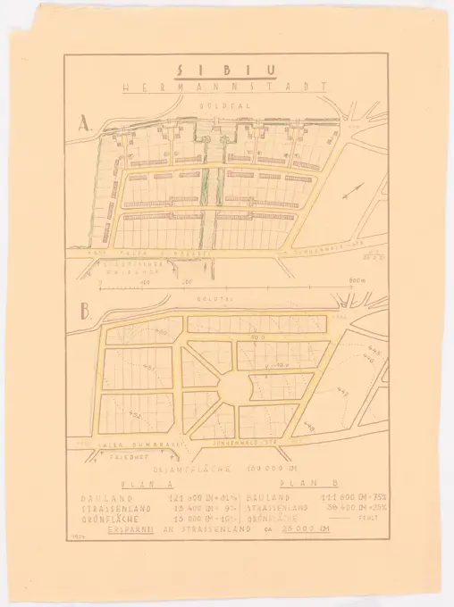
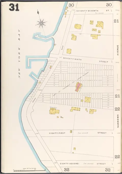
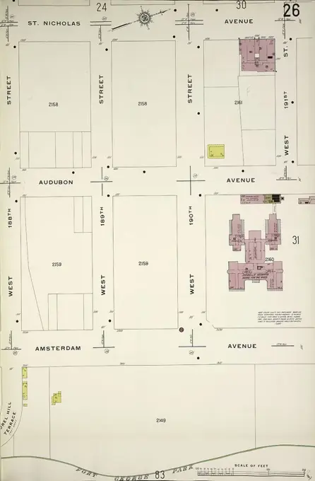
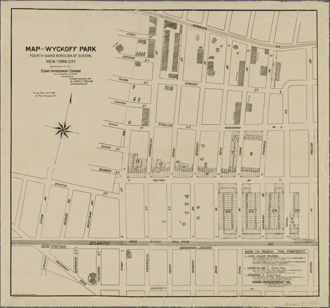
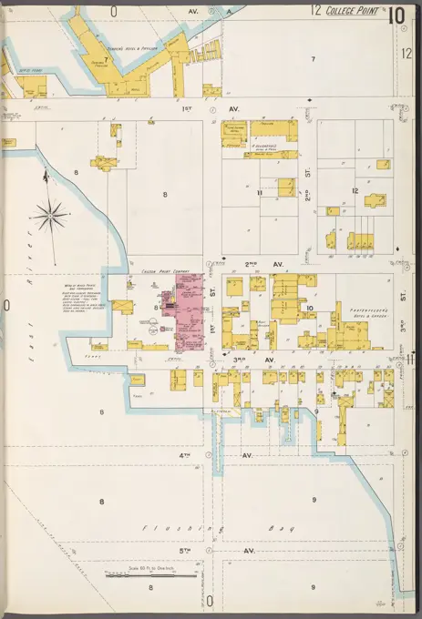
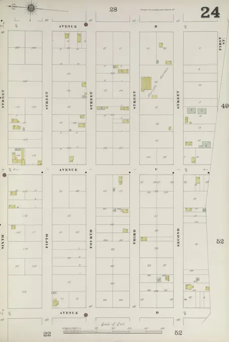
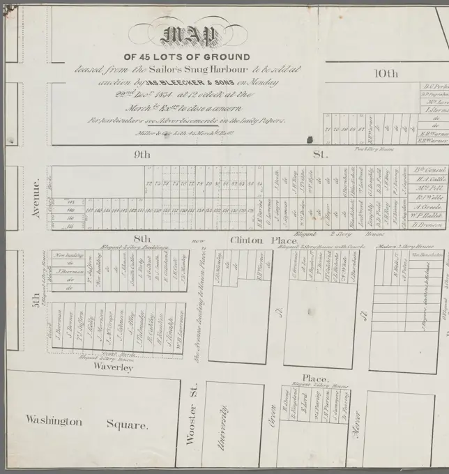
Fire Insurance Maps of New York

Detailed fire insurance maps highlighting real property and city layouts in various New York neighborhoods from the late 19th to early 20th century.

Bronx, V. B, Plate No. 7 Map bounded by Bronx River, Olin Ave., White Plains Rd., Elizabeth St., Newell Ave., 1884-1897, Sanborn Map Company., 1884-1897, New York, Publisher, Sanborn Map Company. Fire insurance, New York (State), Real property, New York (State), Cities & towns, New York (State)
356 assets in this story
6145-55176856
Cartographic, Maps. 1884 - 1936. Lionel Pincus and Princess Firyal Map Division. Fire insurance , New York (State), Real property , New York (State), Cities & towns , New York (State) Key
6145-54525704
Cartographic, Maps. 1911. Lionel Pincus and Princess Firyal Map Division. Fire insurance , New York (State), Real property , New York (State), Cities & towns , New York (State) Manhattan, V. 5, Plate No. 2 Map bounded by Hudson River, West 28th St., 11th Ave., West 25th St.
6145-54523938
Cartographic, Maps. 1884 - 1936. Lionel Pincus and Princess Firyal Map Division. Fire insurance , New York (State), Real property , New York (State), Cities & towns , New York (State) Brooklyn V. 9, Plate No. 80 Map bounded by Newtown Creek, Stagg St., Stewart Ave., Grand St.
6145-55927524
E.B. Hyde & Co.. Cartographic, Maps. 1916 - 1920. Lionel Pincus and Princess Firyal Map Division. Brooklyn (New York, N.Y.), Real property , New York (State) , New York Brooklyn, Vol. 3, Double Page Plate No. 30; Part of Ward 32, Section 24; Map bounded by E. 92nd St., Avenue L; Including E. 80th St., Farragut Rd.
6145-54526546
Cartographic, Maps. 1905 - 1908. Lionel Pincus and Princess Firyal Map Division. New York (N.Y.) Bronx, V. A, Plate No. 6 Map bounded by Williamsbridge Rd., Sacket Ave., Bronxdale Ave., Morris Park Ave.
6145-55177036
Cartographic, Maps. 1895. Lionel Pincus and Princess Firyal Map Division. Fire insurance , New York (State), Real property , New York (State), Cities & towns , New York (State) Manhattan, V. 3, Double Page Plate Map bounded by West St., Hudson River, 13th Ave.
6145-48446835
Jansen Hermann (1869-1945), partial development plan on the Goldtal in Sibiu (Hermannstadt) (February 26, 1927): Basic plan approx. 1: 3000 and tabular area comparisons. Colored pencil over a break on paper, 50 x 37.4 cm (including scan edges) Jansen Hermann  (1869-1945): Teilbebauungsplan Am Goldtal, Sibiu (Hermannstadt)
6145-55927947
Cartographic, Maps. 1884 - 1936. Lionel Pincus and Princess Firyal Map Division. Fire insurance , New York (State), Real property , New York (State), Cities & towns , New York (State) Brooklyn V. 11, Plate No. 99 Map bounded by 86th St., 12th Ave., 11th Ave.
6145-46823937
Reproduction of Brocketts Map of New Haven in 1641 (on same page: Milford in 1646).  Artist: F. R. Honey, American
6145-54525565
Cartographic, Maps. 1884 - 1936. Lionel Pincus and Princess Firyal Map Division. Fire insurance , New York (State), Real property , New York (State), Cities & towns , New York (State) Manhattan, V. 2, Plate No. 55 Map bounded by East River, E. 15th St., Avenue E
6145-54522926
Cartographic, Maps. 1884 - 1936. Lionel Pincus and Princess Firyal Map Division. Fire insurance , New York (State), Real property , New York (State), Cities & towns , New York (State) Brooklyn Vol. A Plate No. 31 Map bounded by New York Bay, 77th St., Narrows Ave., 82nd St.
6145-48445085
Barth Erwin (1880-1933), expansion of the cemeteries in Stolp (04.1930): Floor plan of the northwestern part of the planned expansion of the cemetery with height lines 1: 500, scale bar. Ink on transparent, 78.2 x 62 cm (including scan edges) Barth Erwin  (1880-1933): Erweiterung der Friedhöfe, Stolp
6145-50532849
Boston, Feb. 20 1873 , Boston Mass., Maps Norman B. Leventhal Map Center Collection
6145-55928236
Cartographic, Maps. 1884 - 1936. Lionel Pincus and Princess Firyal Map Division. Fire insurance , New York (State), Real property , New York (State), Cities & towns , New York (State) Staten Island, V. 1, Plate No. 43 Map bounded by Fingerboard Rd., Cleveland Pl., Prospect Ave., Crescent Ave., Richmond Ave., Sand Lane.
6145-52833296
Ink drawing with spring on paper by Carl von Hasenauer showing building plots along the Vienna I ring road, partially washed.
4409-21518257
Vol. 1. Plate, I. Map bound by Herkimer St., Troy Ave., Park Pl., New York Ave.; Including Atlantic Ave., Atlantic Ave., Pacific St., Dean St., Bergen St., St. Marks Ave., Prospect Pl., Brooklyn Aver, Kingston Ave., Albany Ave.
6145-55176430
Cartographic, Maps. 1884 - 1936. Lionel Pincus and Princess Firyal Map Division. Fire insurance , New York (State), Real property , New York (State), Cities & towns , New York (State) Key
6145-54525720
Cartographic, Maps. 1896. Lionel Pincus and Princess Firyal Map Division. Fire insurance , New York (State), Real property , New York (State), Cities & towns , New York (State) Bronx, V. 12, Plate No. 279 Map bounded by Broadway, W., 236th St., Fieldston Rd.
4409-21521690
Manhattan, V. 12, Plate No. 26 Map bounded by St. Nicholas Ave., W. 191st St., Amsterdam Ave., W. 188th St..
4443-75460955
Bronx, V. B, Plate No. 18 map bounded by 2nd St., 20th Ave., 4th St., and 15th Ave., issued by the Sanborn Map Company, with dates ranging from 1884 to 1897. This map relates to fire insurance and real property in New York State, depicting cities and towns within the area
6145-50567883
Insurance map of Boston vol. 3 (South & East Boston) : plate 71 , Fire risk assessment, Massachusetts, Boston, Maps, South Boston Boston, Mass., Maps Norman B. Leventhal Map Center Collection
6145-55176770
Cartographic, Maps. 1908. Lionel Pincus and Princess Firyal Map Division. Fire insurance , New York (State), Real property , New York (State), Cities & towns , New York (State) Key
6145-54524521
Cartographic, Maps. 1884 - 1936. Lionel Pincus and Princess Firyal Map Division. Fire insurance , New York (State), Real property , New York (State), Cities & towns , New York (State) Queens V. 5, Plate No. 54 Map bounded by Broadway, Wilson Ave., Madison Ave., Percy St.
6145-54524473
Cartographic, Maps. 1884 - 1936. Lionel Pincus and Princess Firyal Map Division. Fire insurance , New York (State), Real property , New York (State), Cities & towns , New York (State) Queens V. 5, Plate No. 4 Map bounded by Grand Blvd., Flushing Bay, Jackson Blvd., Maple Ave.
4443-75471805
Plate No. 26 map of the Bronx, bounded by Westchester Creek, 10th St., Avenue B, and 15th St. Published by the Sanborn Map Company, this map was issued between 1884 and 1898 and focuses on fire insurance and real property in New York State
6145-54526514
Cartographic, Maps. 1914. Lionel Pincus and Princess Firyal Map Division. Fire insurance , New York (State), Real property , New York (State), Cities & towns , New York (State) Bronx, V. 13, Plate No. 81 Map bounded by W. 261st St., Hudson River.
4409-21522480
Vol. 1. Plate, K. Map bound by Decatur St., Saratoga Ave., Herkimer St., Howard Ave., Atlantic Ave., Buffalo Ave., Patchen Ave.; Including Bainbridge St., Chauncey St., Marion St., Sumpter St., Mc Dougall St., Fulton St., Hull St., Herkimer St., Ralph A.
6145-55958520
Jersey City, V. 1, Double Page Plate No. 16 Map bounded by Grove St., Newark Ave., Henderson St., Van Vorst St., York St. Cartographic. Atlases, Maps. 1866. Lionel Pincus and Princess Firyal Map Division. Jersey City (N.J.), Fire insurance , New Jersey , Jersey City
6145-48447818
Jansen Hermann (1869-1945), total development plan Ankara. Settlement Bahceli Evler Yapi Cooperifi (14.01.1936): (Light break from Inv.No. 23061), basic and location plan 1: 2000, street profiles 1: 100. Pencil, colored pencil over light break on paper, 62.3 x 43.9 cm (including scan edges) Jansen Hermann  (1869-1945): Gesamtbebauungsplan Ankara. Siedlung Bahceli Evler Yapi Kooperatifi
6145-55176899
Cartographic, Maps. 1884 - 1936. Lionel Pincus and Princess Firyal Map Division. Fire insurance , New York (State), Real property , New York (State), Cities & towns , New York (State) Key continued
6145-50567855
Insurance map of Charlestown : portions of Roxbury (now annexed to Boston) and Cambridge : plate 20 , Fire risk assessment, Massachusetts, Boston, Maps, Real property, Massachusetts, Boston, Maps, Roxbury Boston, Mass., Maps Norman B. Leventhal Map Center Collection
6145-48440625
Poelzig Hans (1869-1936), settlement plans for Berlin-Dahlem (June 3rd, 1932): Waldfriedhof, development plan 1: 500. Pencil on transparent, 50.3 x 95.9 cm (including scan edges)
6145-55175696
Cartographic, Maps. 1880. Lionel Pincus and Princess Firyal Map Division. Brooklyn (New York, N.Y.), Real property , New York (State) , New York Vol. 6. Plate, N. Map bound by S. Sixth St., Broadway, Seventh St., Division Ave., S. Eleventh St., East River; Including S. Eighth St., S. Ninth St., S. Tenth St., First St., Second St., Third St., Fourth St., Fifth St., Sixth St.
6145-55957225
Map of Wyckoff Park, Fourth Ward, Borough of Queens, New York City. 1909. Cartographic. Maps. Lionel Pincus and Princess Firyal Map Division
6145-48455235
Götze H. A., settlement plan with a school house group. Schinkel competition 1931 (1931): development plan 1: 4000. Ink, colored pencil on transparent, 61.6 x 77.7 cm (including scan edges) Götze H. A. : Siedlungsplan mit Schulhausgruppe. Schinkelwettbewerb 1931
4409-21519874
Plate 94: Map bounded by West 42nd Street, Sixth Avenue, West 37th Street, Eighth Avenue. 1857, 1862, Perris and Browne, New York, USA.
6145-50511773
Plan of the city of Boston : plate 8 , Real property, Massachusetts, Boston, Maps, Boston Mass., Maps Norman B. Leventhal Map Center Collection
6145-55916450
Plan of Suffolk Street District : showing estates & buildings as proposed to be taken by the City of Boston under the Act of the Legislature passed June 4th, 1868. Shows area of what is now Bay Village and the South End in Boston.... , Massachusetts  , Suffolk  ,county   , Boston  , South End
6145-50567971
Insurance map of Charlestown : portions of Roxbury (now annexed to Boston) and Cambridge : plate 18 , Fire risk assessment, Massachusetts, Cambridge, Maps, Real property, Massachusetts, Cambridge, Maps, Cambridge Mass., Maps Norman B. Leventhal Map Center Collection
6145-54524477
Cartographic, Maps. 1884 - 1936. Lionel Pincus and Princess Firyal Map Division. Fire insurance , New York (State), Real property , New York (State), Cities & towns , New York (State) Queens V. 5, Plate No. 10 Map bounded by 1st Ave., 3rd St., 5th Ave., East River
6145-54522883
Cartographic, Maps. 1884 - 1936. Lionel Pincus and Princess Firyal Map Division. Fire insurance , New York (State), Real property , New York (State), Cities & towns , New York (State) Brooklyn V. 2, Plate No. 46 Map bounded by Park Ave., Navy St., Flushing Ave., N.Portland Ave.
6145-54525836
Cartographic, Maps. 1897. Lionel Pincus and Princess Firyal Map Division. Fire insurance , New York (State), Real property , New York (State), Cities & towns , New York (State) Bronx, V. B, Plate No. 15 Map bounded by White Plains Rd., 10th Ave., 5th St., 5th Ave.
6145-48447694
Jansen Hermann (1869-1945), total development plan Ankara. Partial development plan exterior (June 2, 1933): Basic plan 1: 2000, Yeni Sehir, property bypass on the water depot. Pencil on transparent, 43.3 x 33.6 cm (including scan edges) Jansen Hermann  (1869-1945): Gesamtbebauungsplan Ankara. Teilbebauungsplan äußere Stadt
4443-75470309
Jersey City, V. 1, Double Page Plate No. 3 Map bounded by Hudson St., Steuben St., Atlantic St., York St., 1866, Jersey City, N.J., Publisher, I.B. Culver & Co., Fire insurance, New Jersey
6145-50511387
Plan of house lots at Oak Sq. Brighton : belonging to Oak Sq. Land Trust , Real property, Massachusetts, Boston, Brighton, Maps, Brighton Boston, Mass., Maps Norman B. Leventhal Map Center Collection
6145-29929092
Cave plan
6145-55924789
Cartographic, Maps. 1884 - 1936. Lionel Pincus and Princess Firyal Map Division. Fire insurance , New York (State), Real property , New York (State), Cities & towns , New York (State) Queens V. 3, Plate No. 98 Map bounded by Central Ave., Newins, Oxford, Buena Vista
6145-48447617
Jansen Hermann (1869-1945), total development plan Ankara. Partial development plan inner city (14.03.1934): basic plan and site plan 1: 2000 inner city, Cankiri C., residential area west. Ink on transparent, 34.9 x 27.3 cm (including scan edges) Jansen Hermann  (1869-1945): Gesamtbebauungsplan Ankara. Teilbebauungsplan innere Stadt
4409-21520827
Plate 59: Map bounded by Barrow Street, Commerce Street, Bleecker Street, Cornelia Street, Sixth Avenue, Hancock Street, Hamersly Street, Hudson Street.
4443-75469785
Bronx, V. A, Plate No. 24 Map bounded by Avenue B, 1st St., Avenue D, 6th St., 1884-1898, Sanborn Map Company, 1898, New York, Publisher, Sanborn Map Company, Fire insurance, New York (State), Real property, New York (State), Cities & towns, New York (State)
6145-55957089
20th ward. Cartographic. Maps. 1897. Lionel Pincus and Princess Firyal Map Division. Brooklyn (New York, N.Y.)
6145-29925596
The old hotels in The Hague and Bergeret de Trouville in 1882 and 1899
6145-55955909
Map of 45 lots of ground leased from the Sailor's Snug Harbour to be sold at auction by Jas. Bleecker & Sons on Monday 22nd Decr. 1834 at 12 o'clock at the Merchts. Exge. to close a concern Cartographic. Cadastral maps, Maps. 1834. Lionel Pincus and Princess Firyal Map Division. United States , New York (State) , New York, Landowners , New York (State) , New York, Real property , New York (State) , New York, Real propery auctions , New York (State) , New York, Greenwich Village (New York, N.Y.), East Village (New York, N.Y.), Manhattan (New York, N.Y.)
6176-66916908
Map of Runnymede Florida, circa 1887
6145-48447830
Jansen Hermann (1869-1945), total development plan Ankara. Workers settlement (29.02.1936): Department 1: 2000, Amele Mahalesi (workers settlement). Ink on transparent, 79.5 x 88 cm (including scan edges) Jansen Hermann  (1869-1945): Gesamtbebauungsplan Ankara. Arbeitersiedlung
6145-55955950
Map of property situated in the 11th & 13th Wards of the city of N. York, belonging to the estate of Henry Eckford, decd., to be sold at auction on Friday, 27th Decer., 1833, by James Bleecker & sons at the Merchants' Exchange Cartographic. Cadastral maps, Maps. 1833. Lionel Pincus and Princess Firyal Map Division. United States , New York (State) , New York, Landowners , New York (State) , New York, Real property , New York (State) , New York, Real propery auctions , New York (State) , New York, Manhattan (New York, N.Y.), Lower East Side (New York, N.Y.)
PREVIOUS
of 4
NEXT
2401 S. Ervay, Suite 206
Dallas, Texas 75215
United States
Get Started
Free ResearchMy BoardsMy Cart
For Creators
How To License Your ContentContributor PortalFrame of Mind
Resources
API accessPricing
Contact
+1 866 236 0087help@viewpictures.co.uk Contact form
©2026 View Pictures. All Rights Reserved. -A
This site is protected by reCAPTCHA and Google Privacy Policy and Terms of Service apply.