My Boards
View Pictures
  • My Boards

Global Climate Change Visuals

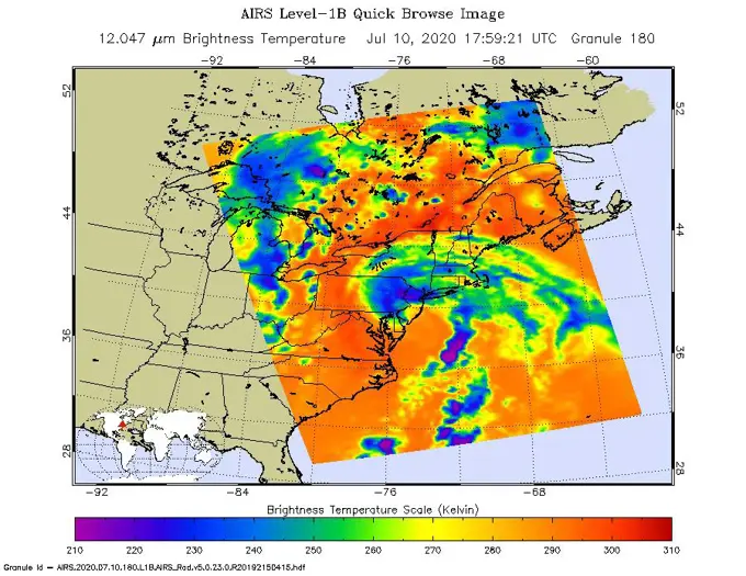
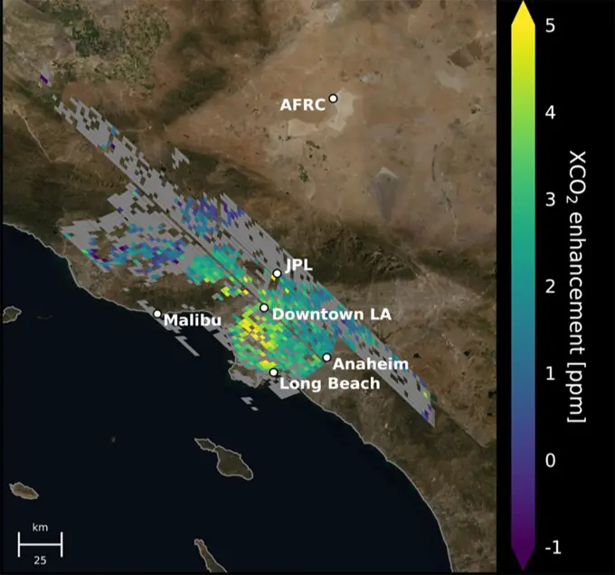
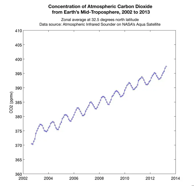
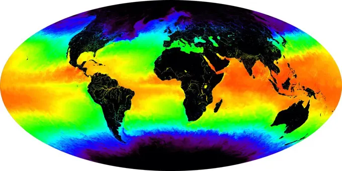
Vivid images depicting ocean temperatures, carbon concentrations, and climate change impacts on Earth from space.

This false-color image shows a one-month composite of sea surface temperature over the entire globe for May 2001. Red and yellow indicates warmer temperatures, green is an intermediate value, while blues and then purples are progressively colder values.
356 assets in this story
6145-45264632
This image, taken at 1 35 pm local time on Tuesday, September 11, 2018 by the Atmospheric Infrared Sounder (AIRS) onboard NASA's Aqua satellite shows Hurricane Florence whose strong winds are expected to reach the Carolina coast late Thursday. Florence intensified from a Category 2 to a Category 4 storm in a matter of hours. As of Tuesday evening, Florence had maximum sustained winds of 140 mph (225 kph). Figure 1 shows Hurricane Florence in visible light, much as our eyes would see it. This is a classic image of a strong hurricane, with a well-defined eye near the center of a large, thick cloud shield containing bands of very thick clouds, and high, thin clouds far from the storm where air flows away from the thick rain clouds. AIRS has more than 2,000 channels that capture various hues of infrared, and this image represents the temperature of the cloud tops and the ocean surface (called brightness temperature in the image). Purple shows very cold clouds high in the atmosphere, blue a
6145-45298511
NASA's Atmospheric Infrared Sounder (AIRS) collected this image of Tropical Storm Fay over New England at around 2 p.m. local time on Friday, July 10. The center of the storm made landfall about 10 miles (15 kilometers) north-northeast of Atlantic City, New Jersey, at around 5 p.m. local time, when Fay had maximum sustained winds of around 50 mph (85 kph). In the infrared AIRS image, the purple regions indicate very cold clouds lofted high into the atmosphere by the storm. These clouds are generally linked to heavy rainfall. Warmer clouds closer to the ground show up as green and blue, while the orange areas denote mostly cloud-free parts of the sky. AIRS, together with the Advanced Microwave Sounding Unit (AMSU), measures the infrared and microwave radiation emitted from Earth to study the planet's weather and climate. Both instruments observe Earth from NASA's Aqua satellite, which launched in 2002. AIRS and AMSU work in tandem to make simultaneous observations down to Earth's surfac
4128-28681059
Earth's internal structure, illustration
6145-44529695
The 2001 Great Dust Storms - Daedalia/Claritas/Syria Dust Plumes
6145-44483644
A relentless heat wave has blanketed India and Pakistan since mid-March 2022, causing dozens of deaths, fires, increased air pollution, and reduced crop yields. NASA's Ecosystem Spaceborne Thermal Radiometer Experiment on Space Station instrument (ECOSTRESS) has been measuring these temperatures from space, at the highest spatial resolution of any satellite instrument. This image, taken shortly before local midnight on May 5, shows urban areas and agricultural lands northwest of Delhi that are home to about 28 million people. The image covers about 4,800 square miles (12,350 square kilometers). Cities are usually markedly warmer than the surrounding countryside due to human activities and the materials used in the built environment. The image clearly delineates these urban heat islands. Nighttime temperatures in Delhi and several smaller villages were above 95 degrees Fahrenheit (35 degrees Celsius), peaking at about 102 degrees F (39 degrees C), while the rural fields nearby had coole
6145-45297023
This animation shows the accumulation of five adjoining swaths of data over the Los Angeles metropolitan area that when combined, create a map of carbon dioxide (CO2) concentrations that covers about 50 square miles (80 square kilometers). Researchers have used the data, collected by NASA's Orbiting Carbon Observatory 3 (OCO-3) instrument aboard the space station, to create one of the most accurate maps ever made from space of the human influence on CO2 abundances in the L.A. Basin Each pixel is about 1.3 miles (2.2 kilometers); the color indicates how much higher the concentration of CO2 is in that spot than in clean desert air north of the city (measured at NASA's Armstrong Research Center, upper right). The highest CO2 readings, in yellow on the map, are on the west side of downtown L.A. - a densely populated area with congested freeways and CO2-emitting industries. Yellow indicates atmospheric CO2 elevated by five or more molecules out of every million molecules of air, or five par
6145-45116789
This graphic indicates a similarity between 2016 (dark blue line) and five past years in which Mars has experienced a global dust storm (orange lines and band), compared to years with no global dust storm (blue-green lines and band).
6145-58967116
Tropical Storm Emily continues its march toward Hispaniola, which it is expected to reach later on Aug. 3. NASA's Aqua spacecraft captured this infrared image 1:53 p.m. EDT on Aug. 3, with the storm located south of Santo Domingo, Dominican Republic.
6145-45263076
On the morning of Oct. 8, 2018, the NASA Soil Moisture Active Passive (SMAP) Radiometer got a snapshot of Hurricane Michael, which has intensified to a Category 2 hurricane over the warm waters of the Gulf of Mexico. The radiance acquired by the SMAP L-band Microwave Radiometer can see through clouds and rains, and is sensitive to the extreme ocean surface winds under a tropical storm or hurricane. Areas in red represent higher wind speeds; areas in blue have lower wind speeds.
6145-45071150
NASA's UAVSAR studies ground deformation after a magnitude 6.0 South Napa earthquake on August 24, 2014.
6145-45261997
The latest infrared image from NASA's Atmospheric Infrared Sounder (AIRS) instrument aboard NASA's Aqua satellite illustrates the growing flood threat from now Tropical Storm Harvey. In the false-color image, acquired at 2 29 p.m. CDT (19 29 UTC) on Aug. 28, 2017, a large area of dark blue and purple centered along the southeastern Texas coast denotes the coldest cloud top temperatures and strongest thunderstorms. A second area of intense precipitation is visible over southeastern Louisiana. Harvey has reemerged over the Gulf of Mexico, but the National Hurricane Center forecasts only a small amount of strengthening before the storm moves slowly north and inland again.
6145-44808696
NASA's Aura spacecraft sees El Nio's effects on the atmosphere. An El Nio is characterized by an abnormal warming of sea surface temperatures in the equatorial central and eastern Pacific Ocean.
6145-44627240
Displayed in blue color is the height of sea surface (shown in blue) measured by NASA's Jason satellite two hours after the initial magnitude 9 earthquake hit the region (shown in red) southwest of Sumatra on December 26, 2004.
6145-45265419
This image shows Tropical Cyclone Fani just off the east coast of India in the Bay of Bengal. NASA's Atmospheric Infrared Sounder (AIRS) collected the image at about 1 p.m. PDT (4 p.m. EDT) today, May 2. At the time, the cyclone's wind speeds were equivalent to a Category 4 hurricane, with maximum sustained winds of 155 mph (249 kph) and gusts of up to 190 mph (306 kph), according to the Joint Typhoon Warning Center. The cyclone is expected to make landfall on Friday, May 3. AIRS, in conjunction with the Advanced Microwave Sounding Unit (AMSU), senses emitted infrared and microwave radiation from Earth to provide a 3D look at weather and climate. The infrared image shows temperatures of the clouds or surface. The large purple area indicates very cold clouds carried high into the atmosphere by deep thunderstorms. Warmer areas, including the eye of the cyclone, are shown in blue. Shallower rain clouds appear green, while the orange areas represent mostly cloud-free air moving away from t
6145-44525750
This image from NASA's Terra satellite of Diamond Valley Lake Reservoir, near the city of Hemet in Riverside County, billed as the largest earthworks construction project in U.S.history.
6145-45133421
This orbital image from NASA's Mars Reconnaissance Orbiter is of the western rim of Mars' Endeavour Crater where the Opportunity rover will investiage whethere the valley was carved by water, wind, or debris flow.
6145-45241545
This map shows the presence of water vapor over global oceans. The imagery was produced by combining Special Sensor Microwave Imager measurements and computer models. This data will help scientists better understand how weather systems move water vapor from the tropics toward the poles producing precipitation.
6145-45262788
ECOSTRESS captured surface temperature variations in Los Angeles, California between July 22 and August 14 -- a period of extended heat -- at different times of day. The images show how different surfaces within the cityscape warm and cool throughout the day. They have been colored to show the hottest areas in red, warm areas in orange and yellow, and cooler areas in blue. The hottest areas are dark asphalt surfaces that have very little shade during the day and remain warm throughout the night due to their higher heat capacity. They include freeways, airports, oil refineries and parking lots. Clouds and higher-elevation mountainous areas were the coolest. More information is available at
6145-44656114
This infrared image shows Tropical Storm Ernesto over Cuba, from the Atmospheric Infrared Sounder (AIRS) on NASA's Aqua satellite in August, 2006.
6145-45298512
NASA's Atmospheric Infrared Sounder (AIRS) was monitoring Tropical Storm Hanna as it took aim at southern Texas on July 26. Perched on NASA's Aqua satellite, AIRS is an instrument that studies Earth's weather and climate. Hanna made landfall as a Category 1 hurricane around 5 p.m. local time over Padre Island, Texas, on July 25. Since then, the storm has lost steam, weakening to a tropical storm in the early morning hours of July 26, and then to a tropical depression by the afternoon. The purple areas in the AIRS image  taken at 1 35 a.m. local time on July 26  show regions within the tropical storm with cold clouds high in Earth's atmosphere that tend to produce heavy rainfall. The National Hurricane Center predicts that Hanna will continue over northeastern Mexico, where it will dissipate by late in the day on July 27.
6145-45155117
NASA and Roscosmos team members, along with Russian Search and Recovery Forces, meet to discuss the readiness for the landing of Expedition 54 crew members Joe Acaba and Mark Vande Hei of NASA and cosmonaut Alexander Misurkin Sunday, Feb. 25, 2018. Acaba, Vande Hei, and Misurkin are returning after 168 days in space where they served as members of the Expedition 53 and 54 crews onboard the International Space Station.
6145-45258934
City lights shine brighter during the holidays in the United States when compared with the rest of the year, as shown using a new analysis of daily data from the NASA-NOAA Suomi NPP satellite. Dark green pixels are areas where lights are 50 percent brighter, or more, during December. Because snow reflects so much light, the researchers could only analyze snow-free cities. They focused on the U.S. West Coast from San Francisco and Los Angeles, and cities south of a rough imaginary line from St. Louis to Washington, D.C.
6145-45097489
Curiosity's Russian-made instrument for checking hydration levels in the ground beneath the rover detected an unusually high amount at a site near 'Marias Pass,' prompting repeated passes over the area to map the hydrogen amounts.
6145-45266661
Image shows OCO-3's first preliminary solar-induced fluorescence (SIF) measurements over western Asia. Solar-induced fluorescence is the glow plants emit from photosynthesis  the process of plant growth that includes the capture of carbon from the atmosphere. Areas with lower photosynthesis activity are in shown in light green; areas with higher photosynthesis activity are shown in dark green. As expected, there is significant contrast in plant activity from areas of low vegetation near the Caspian Sea to areas of more dense vegetation like the forests and farms north and east of the Mingachevir Reservoir (near the center of the image). The mission team expects to complete OCO-3's In-orbit checkout phase  the period where they ensure all instruments and components are working and calibrated correctly  in August 2019. They are scheduled to release official CO2 and solar-induced fluorescence data to the science community a year later; however, the data will likely be available sooner
6145-52930407
Sea Level Visualization of Gulf Stream. This visualization shows sea surface height measurements of the Gulf Stream off the coast of North Carolina and Virginia. The data was collected on Jan. 21, 2023, by seven satellites currently in operation. The information, provided by the Copernicus Marine Service of ESA (European Space Agency), comes from radar instruments called Earth-facing altimeters. In the visualization, red and orange areas represent sea levels that are higher than the global average, while shades of blue represent sea levels that are lower than average. An altimeter - widely used to measure sea level from space - works by bouncing radar signals off the ocean's surface directly beneath the instrument. It records both the time the signal takes to travel from a satellite to Earth and back, as well as the strength of the return signal. The spatial resolution offered by these instruments - shown in the composite image that's been modified so that different sea levels appear a
6145-44760956
OSTM/Jason-2 and Jason-1 Tandem Mission View of the Gulf Stream
6145-45266923
An infrared image of Hurricane Dorian, as seen by the AIRS instrument aboard NASA's Aqua satellite at 1 30 p.m. EDT (10 30 a.m. PDT) on Aug. 29, 2019. The large purple areas are cold clouds, carried high into the atmosphere by deep thunderstorms. Blue and green show warmer areas with less rain clouds, while orange and red represent mostly cloud-free air.
1525-28067853
Isodynames or lines of equal magnetic intensity, vintage engraved illustration. From the Universe and Humanity, 1910.
1525-28067991
Isobars or lines of equal atmospheric pressure for the month of January, vintage engraved illustration. From the Universe and Humanity, 1910.
6145-45298253
TEMPEST-D  a weather-observing satellite the size of a cereal box  captured imagery of Hurricane Dorian off the coast of Puerto Rico in the early morning hours (local time) of Aug. 28, 2019. At a vantage point 250 miles (400 kilometers) above the storm, the CubeSat used its miniaturized radio-wave-based instrument to see through the clouds, revealing areas with strong rain and moisture being pulled into the storm. The green colors show moisture spiraling into the storm's center, and the yellow to pink colors correspond to the most intense rainfall. TEMPEST-D  short for Temporal Experiment for Storms and Tropical Systems Demonstration  is an experiment in shrinking weather satellites to a size that makes them inexpensive enough to produce in multiples. The goal is eventual real-time storm coverage with many small satellites that can track storms around the world.
6145-45046934
Analyses by NASA's UAVSAR radar performed after the Bayou Corne, La., sinkhole formed, show it was able to detect precursory ground surface movement of up to 10.2 inches (260 millimeters) more than a month before the sinkhole collapsed in Aug. 2012.
6145-44965290
Groundwater storage trends around the United States as measured by the NASA/German Aerospace Center Gravity Recovery and Climate Experiment (GRACE) satellites between 2003 and 2012.
6145-54684447
. NASA's AIRS Instrument Tracks Volcanic Sulfur Dioxide Plume from Mauna Loa Eruption. The Atmospheric Infrared Sounder (AIRS) instrument aboard NASA's Aqua satellite detected volcanic sulfur dioxide (SO) plumes emanating from Hawaii's Mauna Loa volcano, which started erupting late Sunday, Nov. 27, 2022, at 11 30 p.m. Hawaiian Standard Time (9 30 a.m. UTC, Nov. 28). The AIRS images shown here were taken from seven overpasses, capturing the SO volcanic plumes and its pathways since the eruption. Starting from the upper left frame  captured at 2 41 a.m. HST (12 41 UTC) on Nov. 28, around three hours after the eruption began  a red patch that represents an SO plume can be seen east of the volcano, which is shown as a blue triangle, then moving east and diffusing through subsequent frames. By 71 hours after the eruption, the eastern part of the plume is over the southeastern United States. SO can be harmful to the human respiratory system when inhaled. In the atmosphere, it can also lead t
6145-44514780
This graphic, released on Dec. 10, 2020, shows the basic radar measurements, called waveforms, collected by the instrument that monitors sea level on the Sentinel-6 Michael Freilich satellite, which launched Nov. 21, 2020. The instrument, called an altimeter, works by bouncing a radar signal off the ocean surface and measuring how long it takes to go out and return. The higher-resolution waveforms focus on a smaller area of the ocean than the lower-resolution waveforms, allowing researchers to resolve smaller ocean features such as currents closer to the coast. The waveform provides information not only on sea level, but also on wave height and wind speed.
6145-45053329
NASA's Aqua spacecraft passed over central and southern United States on April 27-29, 2014 capturing this false-color infrared image of the slow-moving low-pressure system that spawned the strong supercell thunderstorms.
6145-44653341
This is an AIRS infrared image of Tropical Storm Beryl in the western Atlantic, from the NASA's Aqua satellite on July 20, 2006, 1:30 am local time. The image shows the temperature of the cloud tops or the surface of the Earth in cloud-free regions.
6145-45264372
This image from the Atmospheric Infrared Sounder (AIRS) shows the temperature of clouds or the surface in and around Hurricane Michael as it approaches northwestern Florida around 3 AM local time on Tuesday, October 10, 2018. The storm shows all the hallmarks of a powerful, mature hurricane. The large purple area indicates very cold clouds at about -90 F (-68 C) carried high into the atmosphere by deep thunderstorms. These storm clouds are associated with very heavy rainfall. At the center of the cold clouds is the distinct, much warmer eye of the hurricane seen in green. The extensive areas of red away from the storm indicate temperatures of around 60 F (15 C), typical of the surface of the Earth at night. These red areas are mostly cloud-free, with the clear air caused by air motion outward from the cold clouds near the storm center then downward in the surrounding areas. Michael has developed quickly into a dangerous Category 4 storm, with sustained wind of 150 miles per hour. It is
6145-45103249
NASA's ISS-RapidScat instrument on the International Space Station provided a look at the strong winds that led to coastal flooding in southern New Jersey during the historic winter storm that blanketed much of the U.S. East Coast, starting Jan. 23, 2016.
6145-44648485
NASA's CloudSat image of a horizontal cross-section of tropical clouds and thunderstorms over east Africa.
6145-44828361
This image from NASA's Aqua spacecraft shows how surface emissivity -- how efficiently Earth's surface radiates heat -- changed in several regions of Pakistan over a 32-day period between July 11 (pre-flood) and August 12 (post-flood).
6145-51396588
State of Louisiana, highlighting low-lying areas derived from USGS digital elevation data , Louisiana, Relief models, Maps Norman B. Leventhal Map Center Collection
6145-45092846
Using a combination of GPS-measured ground motion data, satellite radar data, and seismic observations, scientists have constructed preliminary estimates of how much April 25, 2015, magnitude 7.8 Gorkha earthquake in Nepal moved below Earth's surface.
6145-52930406
SWOT Satellite's Sea Level 'First Light'. This visualization shows sea surface height measurements in the Gulf Stream off the coast of North Carolina and Virginia. The data was collected on Jan. 21, 2023, by an instrument on the Surface Water and Ocean Topography (SWOT) satellite called the Ka-band Radar Interferometer (KaRIn). KaRIn's two antennas acquired data that was mapped as two wide, colored strips spanning a total of 75 miles (120 kilometers) across. In the visualization, red and orange areas represent sea levels that are higher than the global average, while shades of blue represent sea levels that are lower than average. The spatial resolution of SWOT ocean measurements is 10 times greater than the composite of sea surface height data gathered over the same area by seven other satellites that same day. KaRIn is the scientific heart of the SWOT mission. It's a radar instrument with one antenna at each end of a boom that's 33 feet (10 meters) long. This enables KaRIn to look of
6145-58969850
The total distance driven on Mars by NASA's Mars Exploration Rover, 34.36 kilometers by early December 2011, is approaching the record total for off-Earth driving, held by the robotic Lunokhod 2 rover operated on Earth's moon by the Soviet Union in 1973.
6145-51388072
State of Louisiana, highlighting low-lying areas derived from USGS digital elevation data , Louisiana, Relief models, Maps Norman B. Leventhal Map Center Collection
6145-44705961
Polygon Patterned Ground on Mars and on Earth
6145-44825729
Tropical Storm Bonnie, now a depression, rakes South Florida in this infrared image from NASA's Atmospheric Infrared Sounder , en route to a weekend run-in with the Gulf of Mexico and the Gulf oil spill.
6145-45258367
The radiometer instrument on NASA's Soil Moisture Active Passive (SMAP) spacecraft captured this image of Hurricane Maria at 6 27 a.m. EDT on Sept. 19, 2017 (10 27 UTC), showing an estimated maximum surface wind speed of 126.6 miles per hour (56.6 meters per second). While Maria was already a Category 5 hurricane at the time of this observation, it is an extremely tightly organized hurricane and SMAP cannot fully resolve its highest winds due to the 25-mile (40-kilometer) resolution of SMAP.
6145-44962652
This plot shows the concentration of carbon dioxide in Earth's mid-troposphere at various latitudes as measured by NASA's Aqua satellite. The colored lines represent different latitude bands that circle Earth, called 'zones'.
6145-45264010
GRACE-FO has completed its first mission phase and demonstrated the performance of the precise ranging system that enables its measurements of how mass migrates around Earth. Along the satellites' ground track (top), the inter-spacecraft distance between them changes as the mass distribution underneath (i.e., from mountains, etc.) varies. The small changes measured by the Microwave Ranging Instrument (middle) agree well with topographic features along the orbit (bottom).
6145-45258905
A new series of images generated with data from NASA's Soil Moisture Active Passive (SMAP) satellite illustrate the surface flooding caused by Hurricane Harvey from before its initial landfall through August 27, 2017. The SMAP observations detect the proportion of the ground covered by surface water within the satellite's field of view. The sequence of images depicts successive satellite orbital swath observations showing the surface water conditions on August 22, before Harvey's landfall (left), and then on Aug. 27, two days after landfall (middle). The resulting increase in surface flooding from record rainfall over the three-day period, shown at right, depicts regionally heavy flooding around the Houston metropolitan area. The hardest hit areas (blue and purple shades) cover more than 23,000 square miles (about 59,600 square kilometers) and indicate a more than 1,000-fold increase in surface water cover from rainfall-driven flooding. SMAP's low-frequency (L-band) microwave radiomete
6145-44962651
This graph made with data from the AIRS instrument on NASA's Aqua satellite shows the concentration of carbon dioxide in Earth's mid-troposphere, located roughly between 3 to 6 miles (5 to 9 kilometers) in altitude.
6145-44575139
This is a deformation map of the south flank of Kilauea volcano on the big island of Hawaii, centered at 19.5 degrees north latitude and 155.25 degrees west longitude.
6145-45298780
A spatial map of the amount of carbon dioxide (CO2) present in columns of the atmosphere below NASA's Orbiting Carbon Observatory-2 (OCO-2) satellite as it flew over Las Vegas on Feb. 8, 2018. Warmer colors over the city center indicate higher amounts of carbon dioxide.
6145-51995097
USGS Map of 3.6 Germantown Earthquake.. Photographs Relating to Disasters and Emergency Management Programs, Activities, and Officials
6145-44986748
Spatial distribution of snow water equivalent across the Tuolumne River Basin from April 10 to June 1, 2013 as measured by NASA's Airborne Snow Observatory.
PREVIOUS
of 4
NEXT
2401 S. Ervay, Suite 206
Dallas, Texas 75215
United States
Get Started
Free ResearchMy BoardsMy Cart
For Creators
How To License Your ContentContributor PortalFrame of Mind
Resources
API accessPricing
Contact
+1 866 236 0087help@viewpictures.co.uk Contact form
©2026 View Pictures. All Rights Reserved. -A
This site is protected by reCAPTCHA and Google Privacy Policy and Terms of Service apply.