My Boards
View Pictures
  • My Boards
← Documents & Records

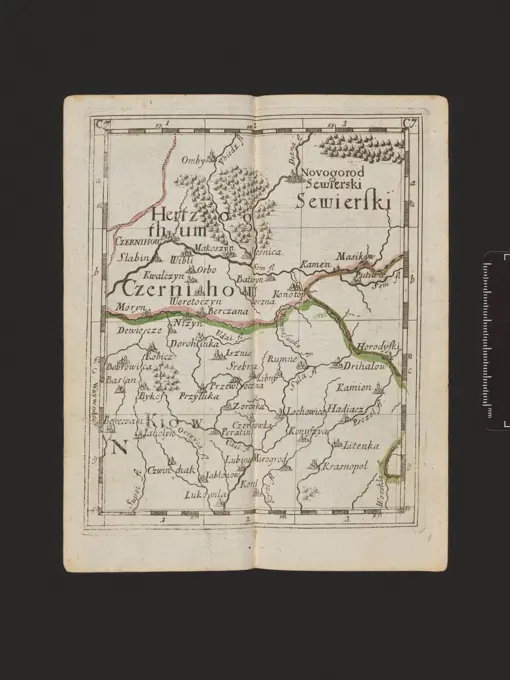
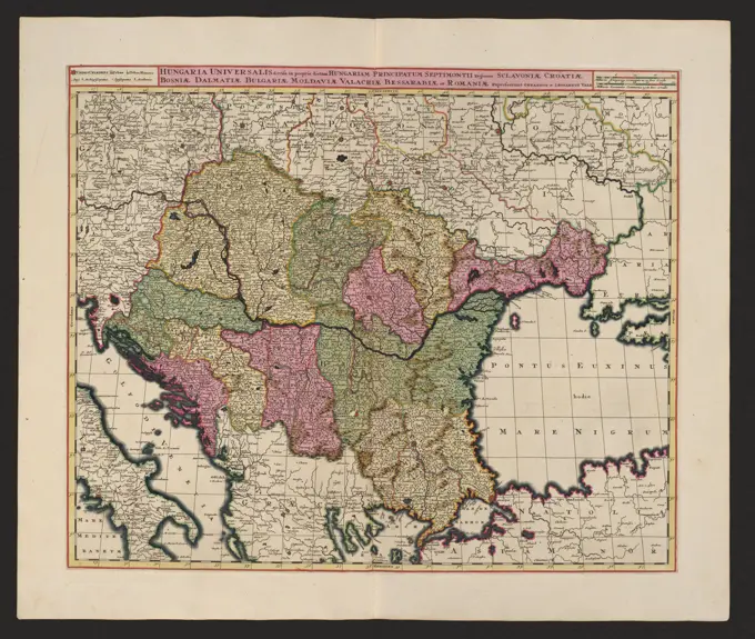
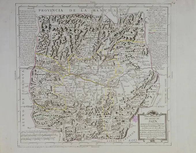
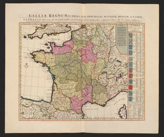
Historic Maps of Europe

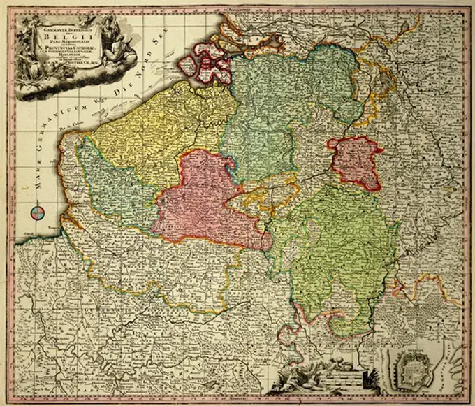
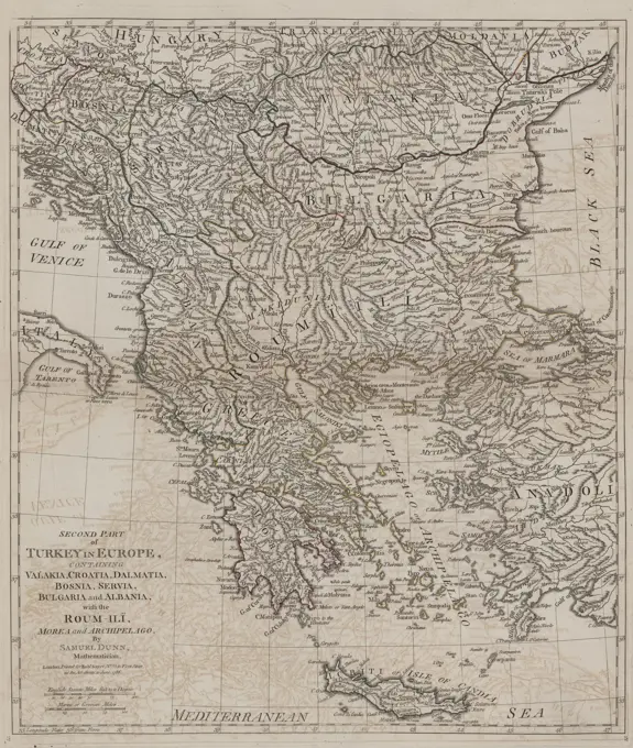
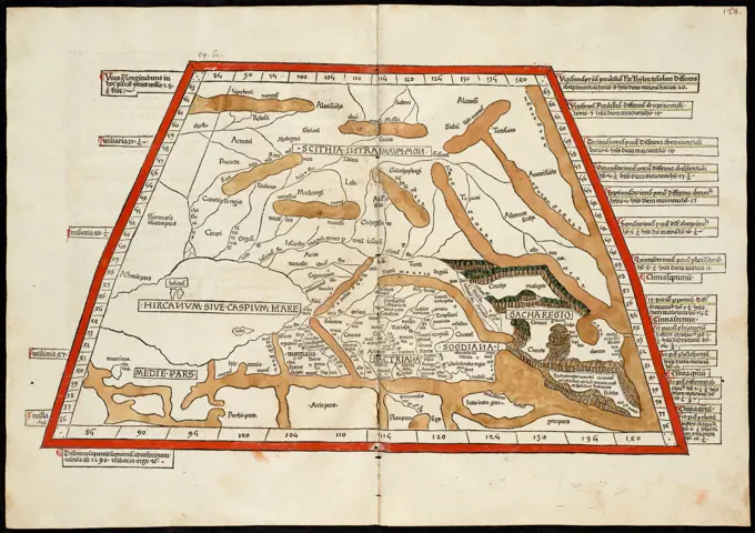
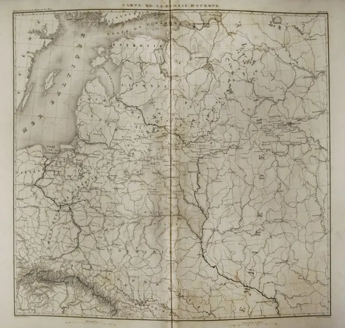
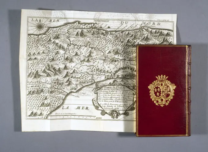
A collection of intricate antique maps spanning various regions in Europe, showcasing historical details and artistic cartouches.

La Beauce , Beauce France, Maps, Early works to 1800, Eure-et-Loire France, Maps, Early works to 1800 Norman B. Leventhal Map Center Collection
270 assets in this story
6145-59587510
Map of the Graafschap Holland, Anonymous, 1683 - 1709 print Map of the Graafschap Holland and surrounding areas. At the bottom left a bet card of the Wadden area with a bowl: common Duysse Mylen 15 in a bone. Among them two scale sticks of the main map: 3 common Duysse Mylen 15 in a bone; 4 Fransse Mylen or Ouren going. Along the top a legend of the ecclesiastical classification of Holland and Utrecht. At the top right of the title cartouche with two river gods, Mercury, a Triton and the Dutch Virgin with the coat of arms of the county behind him. Degree distribution along the edges. Orientation: north on the right.  paper engraving / etching maps of separate countries or regions. coat of arms (as symbol of the state, etc.). (story of) Mercury (Hermes). river-gods. triton(s) Holland. Utrecht
6145-59101853
The province of the Supreme French Prefectures; Vulgariter Gouvernement of Provence, in which the foreign domination of the Romans watching the county of the Avenioniensis and within its limits, his old law. Principled Arausiacus; Schenck, Pieter (1660-1711), Valck, Gerard (1651 or 1652-1726); 1711 (1711-00-00 - 1711-00-00); Pobrano z systemu muza muzeum Narodowego W Warszawie; graficzne / c / c2 / miedzioryt kolorowany; Wyroby z w ókien / Papier / Papier Czerpany / Papier eberkowy; WYS. 49,8 cm, Szer. 58,5 cm; Kart.438 / 3/71 MNW; WSZYSTKIE PREWA ZASTREZE One.
6145-59097640
Eastern Carpathians; Stridbeck, Johann (1665-1714; m CA 1700 (1700-00-00-1710-00-00);
6145-45773342
Map of the region between Mannheim and Landau, 1726; 't area of Landaw,' t Diocese Speir and 't enforcing / territory Landauiae et Spirae, cum vicinis; Les Forces de l'Europe, Asie, Afrique et Amerique (...) Comme Aussi Les Cartes des Côtes de France et d'Espagne. Map of the region between Mannheim, Speyer and Landau. Plate No. 174 in Part VIII of the Picture: Les Forces de l'Europe, Asia, Afrique et amic ... Comme Aussi Les Cartes des Côtes de France et d'Espagne from 1726, this first part with 238 by hand Numbered Plates of renowned strong cities and fortresses in the context of the Spanish Succession War 1701-1713. For most part, these plates have been copied to the anonymous French plates of renowned strong cities and fortresses: in Les Forces de l'Europe and in: Le Theater de la Guerre, Dans Les Pays-Bas, both originally published by Nicolas de Fer in Paris (1693-1697) In the context of the nine-year war.
4430-11531
cartography maps Belgium copper engraving ""Atlas Novus"" by Georg Matthaeus Seutter printed by Peter von Bhelen Vienna 1728 private collection,
6145-55916016
Peru. Relief shown pictorially. Oriented with north to the left. In Latin on verso, with caption titles "Peruvia" and "Peruviae descriptio" and signature "Ccccc." Bar scales in "Miliaria Germanica communia" and "Miliaria Gallica communia." From Jan Jansson and Henrik Hondius's Atlas novus ... Amstelodami : Apud Ionnem Ianssonium & Henricum Hondium, 1638. Cataloging, conservation, and digitization made possible in part by The National Endowment for the Humanities: Exploring the human endeavor... Perv. Perv, Peru
6145-58841920
Map of Catalonia, Anonymous, 1735 Map of Catalonia, surrounded by thirteen smaller floor plans of cities. Part of an atlas with 223 maps of countries and cities and war scenes in Europe in the period ca. 1690-1735. print maker: Northern Netherlandspublisher: Amsterdam paper etching / engraving  Catalonia Map of Catalonia, surrounded by thirteen smaller floor plans of cities. Part of an atlas with 223 maps of countries and cities and war scenes in Europe in the period ca. 1690-1735. print maker: Northern Netherlandspublisher: Amsterdam paper etching / engraving  Catalonia
6145-50569441
Peru , Peru, Maps, Early works to 1800 Norman B. Leventhal Map Center Collection
6145-55956084
North Wales text. Maps, Atlases. 1793. Lionel Pincus and Princess Firyal Map Division. Geography, Great Britain
6145-55917122
La Campagna di Roma il Patrimonio di S. Pietro e la Sabina. Relief shown pictorially. In upper right margin: "Tom. I. no. 33." Map dated 1790. Appears in the author's Nuovo atlante geographico universale delineato sulle ultime osservazioni. Rome: Calcografia Camerale, 1792. Vol. 1, no. 33.... , Italy  , Latian  ,region
6145-59102449
Parte Alpestre Di Milano Con Il Lago Maggiore di Lugano E di Como; Schenck, Pieter (1660-1711), Valck, Gerard (1651 cars 1652-1726); 1711 (1711-00-00-1711-00-00);
1558-13913066
17th century Map of Asia by Blaeuw
4443-19547052
Sampler, Medium: linen, silk Technique: embroidered in stem, cross and satin stitch, Map of Europe embroidered in colored silks on bolting cloth., England, 1786, embroidery & stitching, Sampler
6145-59598645
Map of Northern Greece, Johannes Condet, 1721 - 1774 print   paper engraving maps of separate countries or regions Greece
6145-55956415
Pomerania. Cartographic. Maps, Atlases. 1603. Lionel Pincus and Princess Firyal Map Division. Geography, Pomerania (Germany)
6145-59101872
Valentia regnvm ...; Schenck, Pieter (1660-1711), Valck, Gerard (1651 cars 1652-1726); 1711 (1711-00-00-1711-00-00);
6145-59101791
Les Envirions de l'Estang de Longpendv Comprenant Une Grande Partie du Comté de Charolois ...; Schenck, Pieter (1660-1711), Valck, Gerard (1651 cars 1652-1726); 1711 (1711-00-00-1711-00-00);
6145-50568569
La Campagna di Roma il Patrimonio di S. Pietro e la Sabina , Lazio Italy, Maps, Early works to 1800 Norman B. Leventhal Map Center Collection
6145-58841897
Map of the Dauphiné, Anonymous, 1735 Map of the Dauphiné in France, to the map twelve smaller floor plans and faces on cities. Part of an atlas with 223 maps of countries and cities and war scenes in Europe in the period ca. 1690-1735. print maker: Northern Netherlandspublisher: Amsterdampublisher: Amsterdam paper etching / engraving  Dauphiné Map of the Dauphiné in France, to the map twelve smaller floor plans and faces on cities. Part of an atlas with 223 maps of countries and cities and war scenes in Europe in the period ca. 1690-1735. print maker: Northern Netherlandspublisher: Amsterdampublisher: Amsterdam paper etching / engraving  Dauphiné
6145-51397932
An accurate map of the county of Essex, divided into its hundreds , Essex England, Maps, Early works to 1800 Norman B. Leventhal Map Center Collection
6145-59591523
Map of Rijnland and Amstelland, Anonymous, After Balthasar Florisz. Van Berckenrode, 1661 print Map of Rijnland and Amstelland, the central part of Holland. At the bottom right the title cartouche with a man figure with a rake and a bowl: Milliare Germanicu Commune. Orientation: north on the right.  paper engraving / etching maps of separate countries or regions. agricultural implements: rake Holland. Rijnland. Amstelland
6145-59579186
Map of the Batavian Republic, 1798, 1798 print Map of the Batavian Republic, divided into eight departments, according to the act of state regulation of 23 April 1798. TitleCartouche top left. At the bottom right two scale sticks: Hollandsche Mylen or Uuren Goers / Lieues d'Olande ou Heures de Chemin, common German Mylen / Lieues Communes d'Altemagne. Degree distribution along the edges.  paper etching / engraving maps of separate countries or regions Netherlands
6145-50567791
A mapp of ye county of Essex : with its hundreds , Essex England, Maps, Early works to 1800 Norman B. Leventhal Map Center Collection
4443-75466815
Second part of Turkey in Europe, Robert Sayer, 1788, London, Printed for Robert Sayer, No. 53, Fleet-Street, Second edition with additions, corrections, and improvements. Related to British atlases and early geographical works on Turkey up to 1800
6145-59563563
Map of the Seventeen Provinces, P. Starckman, 1709 - Before 1710 print Map of the seventeen provinces with the areas conquered by France and its allies in the northern and southern Netherlands. At the top left of the title cartouche with around Minerva, Mercury and the weapons of the seventeen provinces. Under the cartouche a table with the coordinates of a few cities. Bottom left a frame with scale: Quinze Lieües des Pais Bas de 20 au Degré.  paper engraving maps of separate countries or regions. (story of) Minerva (Pallas, Athena) Low Countries. Belgium
6145-59101005
Avstria Archidvcatvs; Schenck, Pieter (1660-1711), Valck, Gerard (1651 cars 1652-1726), Janssonius, Johannes (1588-1664); 1711 (1711-00-00-1711-00-00);
1788-35780
Cartography, Italy, 18th century. Duchy of Savoy, Principality of Piedmont, Duchy of Monferrato and County of Nice. Map by Johann Baptist Homann, Nuremberg, 1715. Copper engraving.
6145-59596004
Forts on the Ooster- en Westerschelde, 1627, Anonymous, 1652 - 1658 print Map of forts on the Ooster- en Westerschelde and around Zandvliet, 1627. Perhaps in relation to the attack by Spinola on Zuid-Beveland, September 1627. At the top left the translation of Terms Nederlands- Latin. Below that a bowl: 1 Milliare Commune. With French text on Verso.  paper etching / engraving / letterpress printing maps of separate countries or regions Antwerp. Groenlo. Bergen op Zoom. Oosterschelde. Westerschelde. Zandvliet
6145-51387393
Septima Asia tabula continet Margianam, Bactrianam, Sogdianos, Sacas & Scythiam intra Imaū mōtē , Tajikistan, Maps, Early works to 1800, Kyrgyzstan, Maps, Early works to 1800, Turkmenistan, Maps, Early works to 1800, Uzbekistan, Maps, Early works to 1800, Kazakhstan, Maps, Early works to 1800 Norman B. Leventhal Map Center Collection
6145-55917062
Septima Asia tabula continet Margianam, Bactrianam, Sogdianos, Sacas & Scythiam intra Imau mote. Title from verso. Map of ancient Scythian lands in Central Asia, to the west of the Pamir Mountain range. Relief shown by brown coloring. Engraved on wood with place names in moveable type. Includes names of places and natural features. In margin: notes on latitude. Descriptive text within ornamental borders on verso. Appears in the author's Geographia. Ulm : Lienhart Hol, 16 July 1482. Text in Latin. Cataloging, conservation, and digitization made possible in part by The National Endowment for the Humanities: Exploring the human endeavor.... , Tajikistan Kyrgyzstan Turkmenistan Uzbekistan Kazakhstan
4409-17339298
Napoleonic map of European Russia. Atlas de l'Histoire du Consulat et de l'Empire. History of the Consulate and the Empire of France under Napoleon by Marie Joseph Louis Adolphe Thiers (1797-1877). Drawings by Dufour, engravings by Dyonnet. Edited in Paris, 1864.
6145-29901563
Map of / Department / Yonne (IT)
6145-59584719
Map of Friesland, 1721 - 1774 print At the top right of the deployment card with Vlieland, Terschelling, Ameland and Schiermonnikoog. On the right in the middle two putti with legend and two scale sticks: Mille Germanica Commune / one common Duytsche Myl and 0.5, Dutch mylen or hours of gaens. At the bottom right Cartouche with the Wapen van Friesland above it. Degree distribution along the edges.  paper engraving maps of separate countries or regions. coat of arms (as symbol of the state, etc.) Friesland
6145-59097629
Polesie (Bia Ou, Poland, Ukraine); Stridbeck, Johann (1665-1714; m CA 1700 (1700-00-00-1710-00-00);
6145-59100895
Geographical table in which strongly distinctly, is shown the northern or lower part of the Rhein, Meuse & Moselle & the biggest parts of the Weser, the Mein, the Ems, the Escault, the Issel & the other Rivieres, which Decharge in them, such as the provinces of Low Germany, Westphaliae, Hesse, Archeve & Electorate of Cologne & Treves, with the parties of Majé & le Palatinat. The race of the Rhein river from its source to its mouth or are distinguished all the states and sovereign that are on it and to the Enuirons, draws from all the PLs from all the PLs. new; Schenck, Pieter (1660-1711), Valck, Gerard (1651 AUT 1652-1726), Janssonius, Johannes (1588-1664), Sanson, Nicolas (1600-1667); 1711 (1711-00-00-1711-00-00); Pobrano Z Systemu Muza Muzeum Narodowego W Warszawie; Graficzne / C / C2 / MIEDZIORYT KOLOROWANY; Wyroby z w ókien / paper / czerpany / paper Eberkowy; wys. 49.2 cm, Szer. 56.6 cm; Kart. 438/2/26 minw; Wszystkie prawa zastrze One.
6145-58841861
Map of Lorraine, Anonymous, 1735 Map of Lorraine. Around the map thirteen small floor plans of cities. Part of an atlas with 223 maps of countries and cities and war scenes in Europe in the period ca. 1690-1735. print maker: Northern Netherlandspublisher: Amsterdam paper etching / engraving  Lorraine Map of Lorraine. Around the map thirteen small floor plans of cities. Part of an atlas with 223 maps of countries and cities and war scenes in Europe in the period ca. 1690-1735. print maker: Northern Netherlandspublisher: Amsterdam paper etching / engraving  Lorraine
6145-46756567
Maps and drawings of HM King's properties in Norrbotten and Luleå Lappmark. Authorized by Franz von Scheele 1828. Gällivareverken.kartor, drawings and share letters regarding utility and mining companies.ur Carl Sahlin's mountain history collection.
6145-59591268
Map of Bailiff Kennemerland, Anonymous, 1718 - 1726 print Map of the bailiff Kennemerland. Along the top the title. At the top left of the assignment and the coat of arms of the Amsterdam mayor J (O) An van de Poll (1666-1735) with Putti around it. Bottom left a bowl: scale of 800 rods or half an hour gang. Orientation: the north left.  paper etching / engraving maps of separate countries or regions. maps of cities. armorial bearing, heraldry Kennemerland. Holland. Haarlem
6145-59097635
Czernihowskie Voivodeship, Kiev region (Ukraine); Stridbeck, Johann (1665-1714; m CA 1700 (1700-00-00-1710-00-00);
6145-58837774
Map of Spain and Portugal, 1685 - 1725 Map of Spain and Portugal. At the bottom right a legend, in the bottom right to the bottom right, a list of the areas of Spain in six columns that also include Portugals assets. Left -cut a wind rose and scale in Spanish and German miles and hours. Print is part of an album. Amsterdampublisher: AmsterdamThe Hague paper engraving  Spain. Portugal Map of Spain and Portugal. At the bottom right a legend, in the bottom right to the bottom right, a list of the areas of Spain in six columns that also include Portugals assets. Left -cut a wind rose and scale in Spanish and German miles and hours. Print is part of an album. Amsterdampublisher: AmsterdamThe Hague paper engraving  Spain. Portugal
6145-46481619
Map of Noord-Holland. Map of Noord-Holland. Part of an Atlas with 223 maps of countries and cities and war scaffolding in Europe in the period approx. 1690-1735.
6145-59102761
Hungaria Universalis Divisa in Proprie Dictam Hungariam Principatus Septimonti Regions Sclavoniae, Croatiae, Bosniae, Dalmatiae, Bulagriae, Moldaviae, Valachiae, Bessarabiae et Romaniae; Schenck, Pieter (1660-1711), Valck, Gerard (1651 cars 1652-1726); 1711 (1711-00-00-1711-00-00);
6145-50567777
Anglesey : Wight Vectis olim ; Garnesay ; Iarsay , England, Maps, Early works to 1800, Isle of Wight England, Maps, Early works to 1800, Anglesey Wales, Maps, Early works to 1800, Jersey Channel Islands, Maps, Early works to 1800, Guernsey Channel Islands, Maps, Early works to 1800 Norman B. Leventhal Map Center Collection
4409-14438
MAPA DEL REINO DE JAEN 1767. Author: LOPEZ TOMAS. Location: BIBLIOTECA NACIONAL-COLECCION. MADRID. SPAIN.
6145-50556862
A New and accurate map of Radnor Shire , Radnorshire Wales, Maps, Early works to 1800 Norman B. Leventhal Map Center Collection
6145-55915458
A New and accurate map of Radnor Shire. Relief shown pictorially. Imprint from published bibliography.... , Wales  , Radnor  ,area
6145-58841884
Map of Europe, Anonymous, 1735 Map of Europe, at the top right a vignette with Europe on the bull, on the sides twenty weapons of countries. Part of an atlas with 223 maps of countries and cities and war scenes in Europe in the period ca. 1690-1735. print maker: Northern Netherlandspublisher: Amsterdampublisher: Amsterdam paper engraving  Europe Map of Europe, at the top right a vignette with Europe on the bull, on the sides twenty weapons of countries. Part of an atlas with 223 maps of countries and cities and war scenes in Europe in the period ca. 1690-1735. print maker: Northern Netherlandspublisher: Amsterdampublisher: Amsterdam paper engraving  Europe
6145-59100873
Flandria Gallica Containns Castellanias, Insurelem, Ducens, orchiannens, Dominiumq Tornacens ciuitate; Schenck, Pieter (1660-1711), Valck, Gerard (1651 cars 1652-1726), Janssonius, Johannes (1588-1664); 1711 (1711-00-00-1711-00-00);
6145-59219788
Map of Europe, Anonymous, 1774 print  Germany paper etching (map of) Europe Europe
6145-59584365
Map of the Republic of the Seven United Netherlands, After 1682 print At the top left Cartouche with title and the weapon of the Republic, around it, various figures are depicted: Urania, Fama, Mercury, Neptune and a number of putti. At the bottom right a bet card of part of the current Limburg (part that belonged to Staats-Brabant at the time). Below that: Milliaria Germanica Communia, Milliaria Gallica Communia. The map is equipped with a coordinates network and a degree distribution along the edges.  paper engraving maps of separate countries or regions. coat of arms (as symbol of the state, etc.). Urania (one of the Muses); 'Urania' (Ripa). Fame; 'Fama', 'Fama buona', 'Fama chiara' (Ripa). (story of) Mercury (Hermes). (story of) Neptune (Poseidon) Netherlands
6145-48718551
Spain and Portugal, from the best authorities , Iberian Peninsula, Maps, Portugal, Maps, Spain, Maps Norman B. Leventhal Map Center Collection
6145-51387374
Secunda Europae tabula , Iberian Peninsula, Maps Norman B. Leventhal Map Center Collection
6145-55917052
Secunda Europae tabula. Map of the Iberian peninsula. Relief shown pictorially. Engraved on wood with place names in moveable type. Shows names of place and natural features. In margin: climactic and latitudinal notes. Appears in the author's Geographia, edited by Bernard Sylvanus. Venetiis : Per Iacobum Pentium de Leucho, anno Domini 1511. Text in Latin. Cataloging, conservation, and digitization made possible in part by The National Endowment for the Humanities: Exploring the human endeavor.... , Iberian Peninsula  ,area  Spain Portugal
6145-59308631
Map of the Heerlijkheid Noordwelle, Anonymous, 1649 - 1658 drawing Map of the Heerlijkheid Noordwelle, located on Schouwen, belonging to Jonkheer Adriaen van Tuyll van Serooskerken, lord of Welland and Kattendijke (born between 1625 and 1639, died in 1658). There are three coats of arms on the map, from left to right: the coat of arms of Serooskerke; The weapon of North and Zuidwelle; Renesse's weapon.  paper. ink pen / brush maps of separate countries or regions. coat of arms (as symbol of the state, etc.) Welland
6145-55180778
Hungaria. Cartographic. Maps, Atlases. 1603. Lionel Pincus and Princess Firyal Map Division. Geography, Danube River, Hungary
6145-50520016
Spain and Portugal, from the best authorities , Iberian Peninsula, Maps, Portugal, Maps, Spain, Maps Norman B. Leventhal Map Center Collection
6145-59101671
Galliae reggnum in omnes suas provincias accurate divisum = la france dresse sur un Grand nombre de cartes Particulieres, Manuscrites Ou imprimees, level fur les lieux, et conferees avec les itineriaires anciens et moderation; Schenck, Pieter (1660-1711), Valck, Gerard (1651 cars 1652-1726); 1711 (1711-00-00-1711-00-00);
6145-55914686
A map of the British and French dominions in North America, with the roads, distances, limits, and extent of the settlements. Relief shown pictorially. First Dutch edition. Includes text and ill. Insets: Plan of the town of Halifax in Nova Scotia -- Plan du port et ville de Louisbourg dans l'Isle Royale -- Plan de la ville de Quebec -- A new map of Hudsons Bay and Labrador from the late surveys of those coasts. Cataloging, conservation, and digitization made possible in part by The National Endowment for the Humanities: Exploring the human endeavor.... , North America  ,area
6145-59563570
Map of the Seventeen Provinces, Anonymous, 1705 print Map of the seventeen provinces. On the map, various field and naval battles are shown in the northern and southern Netherlands dating from the outbreak of the Dutch uprising to the Spanish Succession War. At the top left a bet with the coasts of France and England and various naval battles in the channel. In addition, the weapons of the seventeen provinces. The card is equipped with a search schedule and a degree distribution along the edges. To the left of the map a French text about the history of the Netherlands and a legend.  paper engraving maps of cities. battle (+ naval force) Low Countries. Belgium. France. England. North Sea. Zuiderzee. English Channel
6145-59232269
Map of the Sevennes Mountains in the Languedoc, 1680 - 1699 print Map of the Sevennes Mountains in the Languedoc where the Malcontents are staying, with the large royal roads laid out by order of the French King Louis XIV, ca. 1680-1699. With a place register in Dutch and French under the plate. print maker: Northern Netherlandspublisher: Amsterdam paper etching maps of separate countries or regions Languedoc
6145-50552993
Maps of Europe , Europe, Maps Norman B. Leventhal Map Center Collection
6145-59102764
Partis Hungariae Inter Tibiscum et Nigrum Chrysum Nova et Accurata Descriptio.; Schenck, Pieter (1660-1711), Valck, Gerard (1651 cars 1652-1726); 1711 (1711-00-00-1711-00-00);
6145-48725109
Patavinum Teritor - Territorio di Padova ,. Ralph Finos Map Collection
6145-59043508
History of the adventurers, the Boucaniers and the Chamber of Accounts established in the Indies, 1743, Tome II Page 97: Map of the unfolded and flat Panama isthmus of the binding. 1743 ". Print. Museum of Fine Arts of the City of Paris, Petit Palais. Adventurer, boucanier, geography map, chamber accounts, deployed, establishment, geographical, history, print, indes, isthme, page 97, piracy, dish binding, panama, binding, volume II
6145-55958749
Spain and Portugal, with their general divisions 1786. Dunn, Samuel, d. 1794. Cartographic. Maps. Lionel Pincus and Princess Firyal Map Division. Atlases, British, Geography, Spain, Portugal
6145-59097620
Mi Stridbeck, Johann (1665-1714; m CA 1700 (1700-00-00-1710-00-00);
6145-59608312
Map of England in an ornamental frame, Barwick, 1593  A round plate with a map of England printed in an ornamental frame of a separate plate, richly decorated with rolling, birds, flowers and fabuling animals.  paper engraving ornament derived from animal forms. maps of separate countries or regions England
6145-55956413
Flandria. The Countie of Flaunders. Cartographic. Maps, Atlases. 1603. Lionel Pincus and Princess Firyal Map Division. Geography, Flanders (Belgium)
6145-55955144
Portugall. Flamsteed, John, 1646-1719. Godbid, A.. Cartographic. Maps, Atlases. 1681. Lionel Pincus and Princess Firyal Map Division. Astronomy, 1681, Geography, Mathematics
6145-54548415
Mare del Nort. Cartographic. Maps. 1599. Lionel Pincus and Princess Firyal Map Division. North Atlantic Ocean , Maps , Early works to 1800
PREVIOUS
of 3
NEXT
2401 S. Ervay, Suite 206
Dallas, Texas 75215
United States
Get Started
Free ResearchMy BoardsMy Cart
For Creators
How To License Your ContentContributor PortalFrame of Mind
Resources
API accessPricing
Contact
+1 866 236 0087help@viewpictures.co.uk Contact form
©2026 View Pictures. All Rights Reserved. -A
This site is protected by reCAPTCHA and Google Privacy Policy and Terms of Service apply.