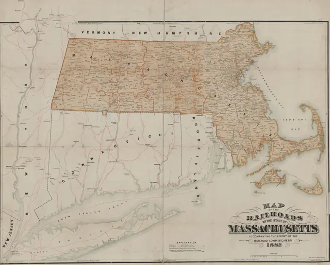
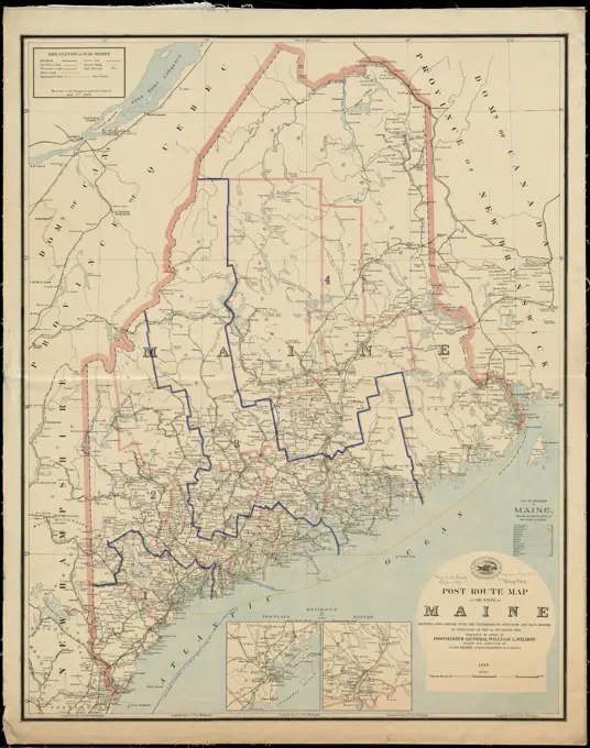
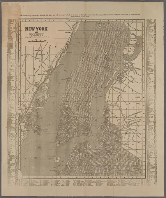
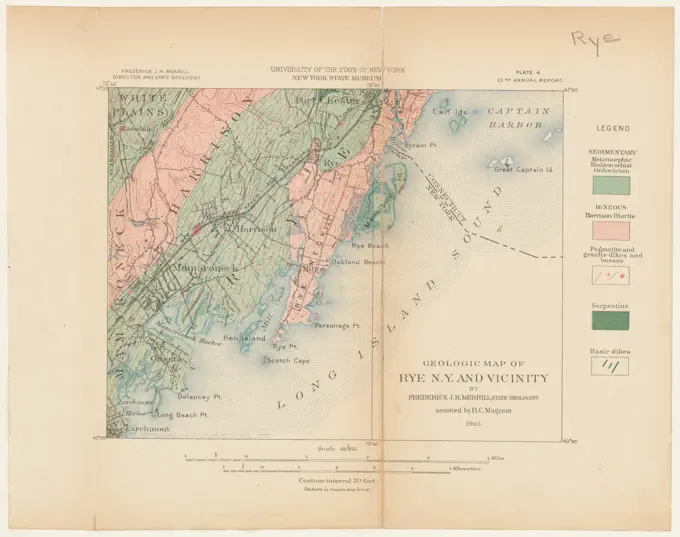
Historic Maps of New England and New York

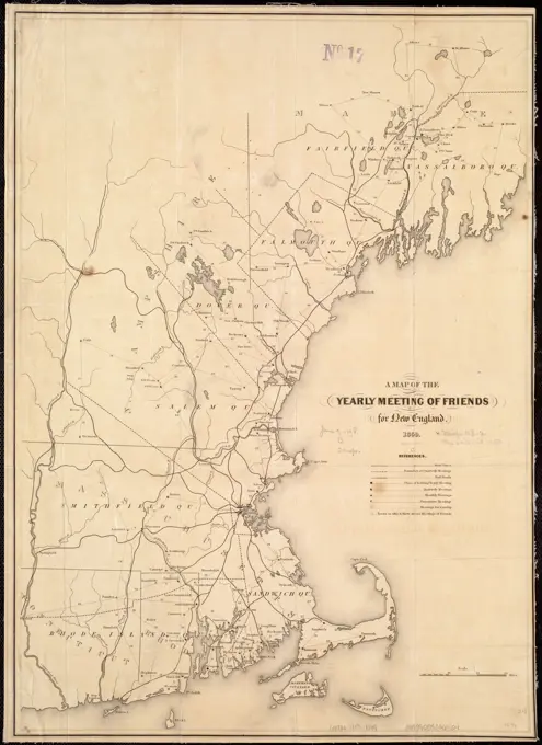
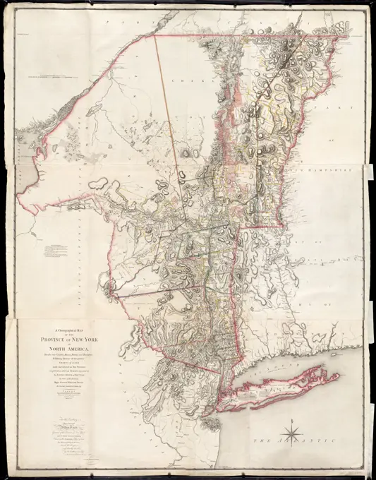
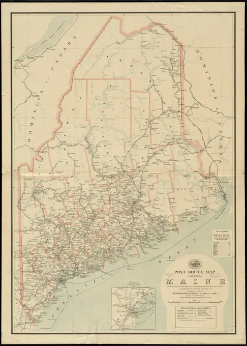
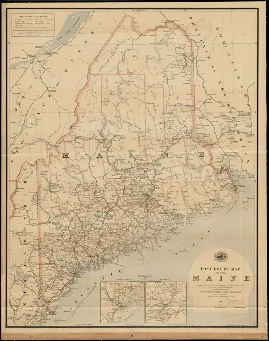
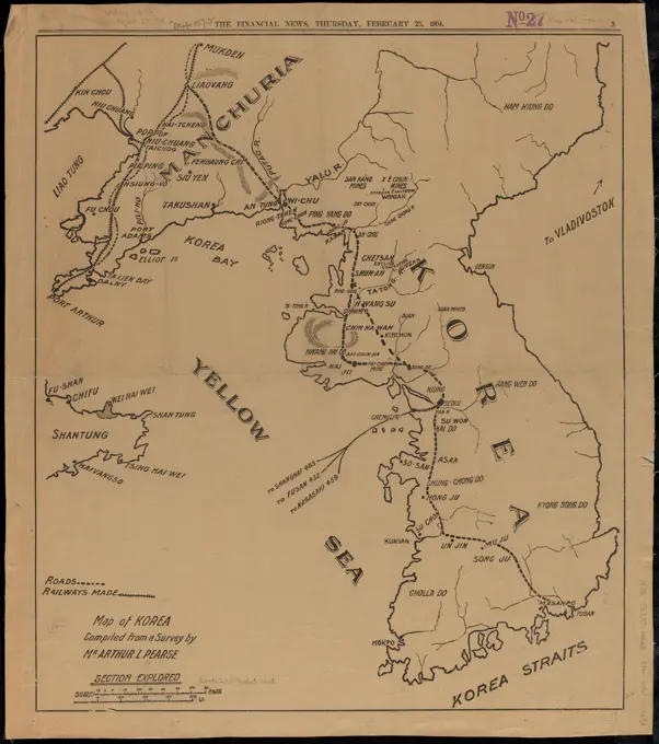
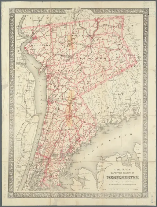
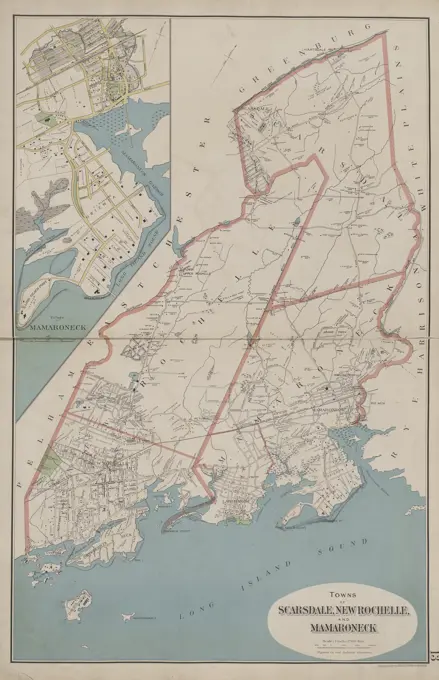
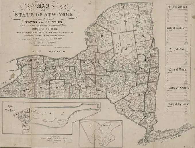
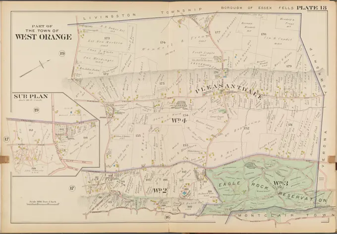
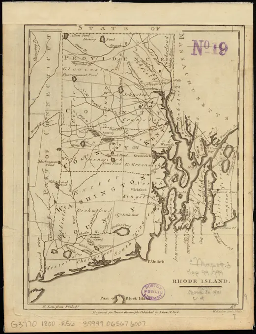
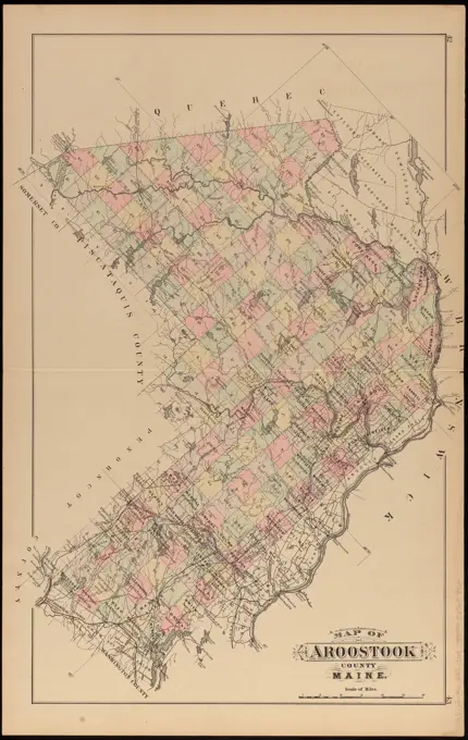
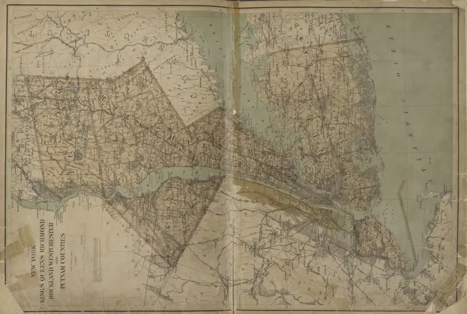
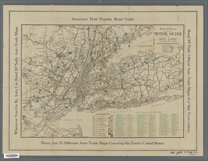
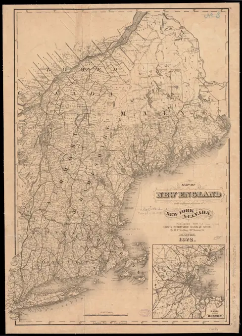
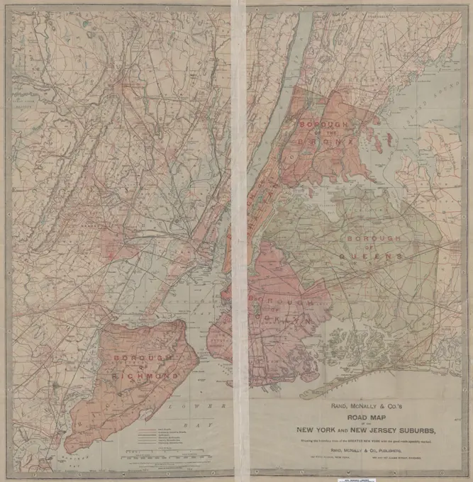
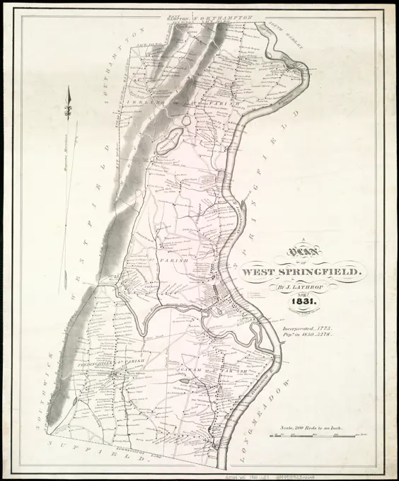
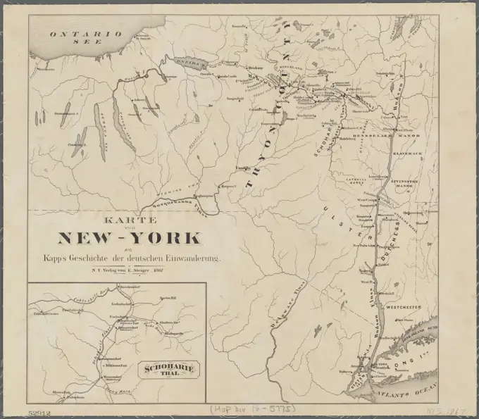
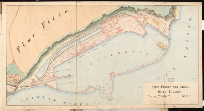
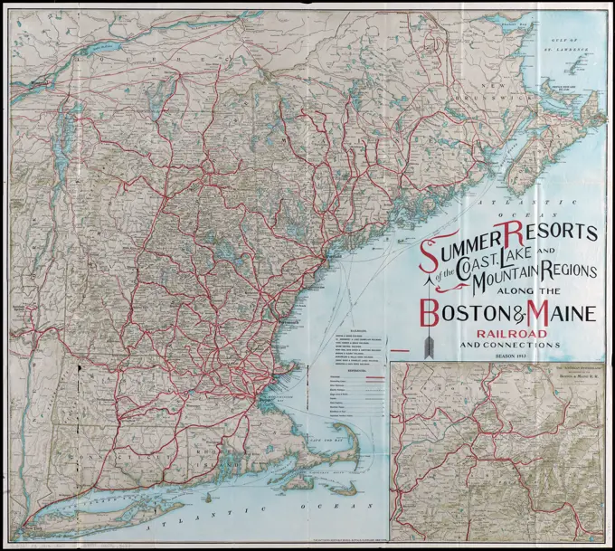
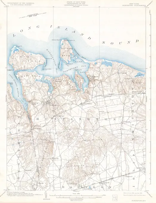
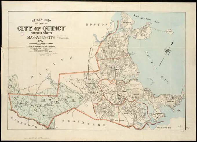
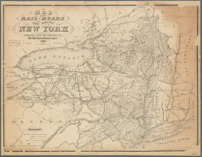
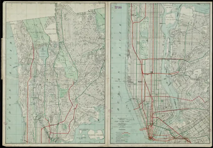
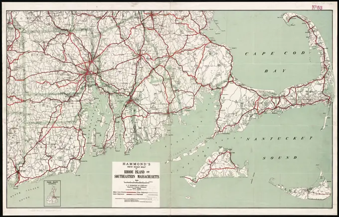
Collection of vintage maps showcasing railways, counties, and townships in New England and New York, illustrated with detailed geographic features.

A chorographical map of the Province of New-York in North America, divided into counties, manors, patents and townships : exhibiting likewise all the private grants of land made and located in that Province , Real property, New York State, Maps, Early works to 1800, New York State, Maps, Early works to 1800, New York State, Administrative and political divisions, Maps, Early works to 1800 Norman B. Leventhal Map Center Collection
Map first division railway mail service , Postal service, New England, Maps, Railroads, New England, Maps, Railway mail service, New England, Maps, New England, Maps Norman B. Leventhal Map Center CollectionA chorographical map of the Province of New-York in North America, divided into counties, manors, patents and townships : exhibiting likewise all the private grants of land made and located in that Province , Real property, New York State, Maps, Early works to 1800, New York State, Maps, Early works to 1800, New York State, Administrative and political divisions, Maps, Early works to 1800 Norman B. Leventhal Map Center CollectionA map of the Yearly Meeting of Friends for New England : 1850 , Society of Friends, New England, Railroads, New England, Maps, New England, Maps Norman B. Leventhal Map Center CollectionTopographic map of Massachusetts and Rhode Island , Massachusetts, Maps, Rhode Island, Maps Norman B. Leventhal Map Center CollectionA chorographical map of the Province of New-York in North America, divided into counties, manors, patents and townships : exhibiting likewise all the private grants of land made and located in that Province. Relief shown by hachures. Depths shown by form lines. Hand colored. Prime meridian: London. Inscribed: To His Excellency Major General William Tryon ... "Advertisement. The tracts of land coloured red, are military grants ... Those with a green edge are manors, and those coloured yellow are townships ... " Appears in Thomas Jefferys' The American atlas. 1776. Cataloging, conservation, and digitization made possible in part by The National Endowment for the Humanities: Exploring the human endeavor.... , New YorkAn accurate map of Rhode Island, part of Connecticut and Massachusets, shewing Admiral Arbuthnot's station in blocking up Admiral Ternay , New England, Maps, Early works to 1800, Connecticut, Maps, Early works to 1800, Rhode Island, Maps, Early works to 1800, Massachusetts, Maps, Early works to 1800, United States, History, Revolution, 1775-1783, Naval operations, Maps Norman B. Leventhal Map Center CollectionPost route map of the state of Maine showing post offices with the intermediate distances on mail routes in operation on the 1st. of December 1897 , Counties, Maine, Maps, Postal service, Maine, Maps, Railroads, Maine, Maps, Maine, Maps Norman B. Leventhal Map Center CollectionMap of the railroads of the state of Massachusetts : accompanying the report of the railroad commissioners : 1899 , Railroads, Massachusetts, Maps, Narrow gauge railroads, Massachusetts, Maps, Massachusetts, Maps Norman B. Leventhal Map Center CollectionMap of north eastern China , China, Maps Norman B. Leventhal Map Center CollectionMap of the railroads of Connecticut : to accompany the report of the Railroad Commissioners. Covers Connecticut, Massachusetts, Rhode Island, and part of New York. Prime meridian: Washington. Also shows steamboat routes.... , Massachusetts Rhode Island ConnecticutPost route map of the State of Maine showing post offices with the intermediate distances and mail routes in operation on the 1st of October 1891 , Counties, Maine, Maps, Postal service, Maine, Maps, Post roads, Maine, Maps, Railway mail service, Maine, Maps, Railroads, Maine, Maps, Maine, Maps Norman B. Leventhal Map Center CollectionMap of Maine from 1835 by T.G. Bradford, featuring hand coloring. The map measures 26 x 19 cm, printed on a sheet that is 30 x 25 cm. Published in Boston, MassachusettsMap of parts of Connecticut, Long Island, New York State and New Jersey. 1916. Cartographic. Maps. Lionel Pincus and Princess Firyal Map DivisionMap of Korea. Shows major roads and railroads in Korea and part of Manchuria. Page 3 from the Financial News, Thursday, February 25, 1904. Text on verso.... , North Korea South Korea China  , Manchuria  ,areaColton's map of the county of Westchester Map of the county of Westchester Colton's road map of Westchester County, New York Cartographic. Maps, Road maps. 1892. Lionel Pincus and Princess Firyal Map Division. Roads , New York (State) , Westchester County, Aqueducts , New York (State) , Westchester County, Railroads , New York (State) , Westchester County, Westchester County (N.Y.), New York Metropolitan Area, Bronx (New York, N.Y.), New York (State) , Westchester CountyWestchester, Double Page Plate No. 13 Map of Towns of Scarsdale, New Rochelle, and Mamaroneck, 1893, Bien, Joseph R., 1893, New York, Publisher, Bien, Joseph R., Westchester County (N.Y.)Map of the State of New York exhibiting the several towns and counties together with the population as determined by the census of 1850., 1851., New York. Publisher, G. Hayward. The map features election districts, administrative and political divisions, and population details for New York State, specifically highlighting Brooklyn., 1 map, hand colored; 44 x 57 cm, on sheet 46 x 59 cmPart of the town of West Orange. Double Page Plate No. 18 Map bounded by West End Ave., Upper Mountain Ave., Mountain Ave., Gregory Ave., Mt. Pleasant Ave. Cartographic. Atlases, Maps, Cadastral maps. 1904. Lionel Pincus and Princess Firyal Map Division. Essex County (N.J.), Real property , New Jersey , Essex County (N.J.)Map of the greater New York and vicinity ,. Robert E. Diefenbach Map CollectionRapid Transit Map of Kings, Queens, and Nassau Counties, Long Island. 1906. Cartographic. Maps. Lionel Pincus and Princess Firyal Map DivisionMap of Newport, R.I , Real property, Rhode Island, Newport, Maps, Landowners, Rhode Island, Newport, Maps, Newport R.I., Maps Norman B. Leventhal Map Center CollectionPost route map of the state of New York showing post offices with the intermediate distances on mail routes in operation on the 1st of December, 1903 , Counties, New York State, Maps, Postal service, New York State, Maps, Railroads, New York State, Maps, New York State, Maps Norman B. Leventhal Map Center CollectionState of Maine , Water-power, Maine, Maps, Hydroelectric power plants, Maine, Maps, Maine, Maps Norman B. Leventhal Map Center CollectionRhode Island , Rhode Island, Maps Norman B. Leventhal Map Center CollectionRhode Island. Relief shown by hachures. "Entered according to Act of Congress in the year 1838 by T.G. Bradford in the ... District Court of Massachusetts." Prime meridian: Washington. Leventhal Map Center copy gift of Bank of America.... , Rhode IslandPath map of the eastern part of Mount Desert Island, Maine , Trails, Maine, Mount Desert Island, Maps, Mount Desert Island Me., Maps Norman B. Leventhal Map Center CollectionMap of the greater New York and vicinity ,. Robert E. Diefenbach Map CollectionG. Woolworth Colton's railroad, township & distance map of New England : with adjacent portions of New York, Canada & New Brunswick. Relief shown by hachures. "Entered according to Act of Congress, in the year 1860, by G. Woolworth Colton in the Clerk's Office of the District Court of the United States for the Southern District of New York." Prime meridians: Greenwich, Washington, D.C. Inset: The eastern portion of Massachusetts on an enlarged scale. Includes table of distances. Gift; Richard H. Brown; 2012. BRL.. Railroad, township & distance map of New England Railroad, township and distance map of New England G. Woolworth Colton's county & township railroad map of New England showing every station &c. Railroad, township & distance map of New England Railroad, township and distance map of New England G. Woolworth Colton's county & township railroad map of New England showing every station &c, New England  ,areaNord Holande campaign of 1799. Military France, Frédéric Auguste La Guillermie, 1860 - 1899 print Map of Noord-Holland, battlefield of the British-Russian invasion in 1799. France paper etching / engraving maps of separate countries or regions North HollandThe Country twenty five miles round New York Cartographic. Maps, Early works to 1800. 1777-01-01. Lionel Pincus and Princess Firyal Map Division. New York (N.Y.), New York Region , History , Revolution, 1775-1783, New York Region, United States , History , Revolution, 1775-1783 , ChronologyRhode Island , Rhode Island, Maps Norman B. Leventhal Map Center CollectionMap of Aroostook County, Maine , Aroostook County Me., Maps Norman B. Leventhal Map Center CollectionBelt lines tentatively adopted and presented for public consideration. 1921. Cartographic. Maps. Lionel Pincus and Princess Firyal Map DivisionCarte du nouveau continent : selon sa plus grande longueur diametrale depuis la Riviere de la Plata jusqu'au de la du Lac des Assiniboils. Relief shown by hachures.... , North and Central America South America Mesoamerica  ,area  North America  ,area  South America AmericaPost route map of the State of New York showing post offices with the intermediate distances on mail routes in operation on the 1st of September, 1897. Post route map of the State of New York showing post offices with the intermediate distances on mail routes in operation on the 1st of September, 1897New York State, Double Page Plate No. 6 Map of Kings, Queens, Richmond, Rockland, Westchester, and Putnam Counties, issued in 1895 by Joseph R. Bien, New YorkOfficial motor guide to golf links, New York City and vicinity, showing parts of N. J., Conn., and Long Island. 1921. Cartographic. Maps. Lionel Pincus and Princess Firyal Map DivisionPlan of Bridgewater, surveyor's name not given, dated 1830 ,. Massachusetts. Office of the Secretary of StateStreet guide of Manhattan and the Bronx. Index to streets on margin and verso. Equipped with Pleasants Instantaneous Finder 1920. Cartographic. Maps. Lionel Pincus and Princess Firyal Map DivisionA map of Berkshire County Mass , Berkshire County Mass., Maps Norman B. Leventhal Map Center CollectionMap of New England with adjacent portions of New York & Canada. Shows railroads, townships, counties, and populated places. Relief shown by hachures. "Published for Snow's pathfinder railway guide, by H.F. Walling." Inset: 15 miles around Boston. "Published for Snow's Pathfinder railway guide." In right margin: 32 -- 33.... , New England  ,areaMap of New York City, highlighting portions of Brooklyn, Jersey City, and Westchester County. This road map, created by Rand, McNally & Co. in 1899, illustrates the boundary lines of Greater New York and marks the good roads. It features both sides of the sheet, measuring 67 x 64 cm, and includes details such as ferries, local transit, and railroads within the New York Metropolitan Area. The map was published in Chicago, IllinoisPath map of the eastern part of Mount Desert Island, Maine , Trails, Maine, Mount Desert Island, Maps, Mount Desert Island Me., Maps Norman B. Leventhal Map Center CollectionMap of the county of Suffolk 1829 - 1839. Cartographic. Atlases, Maps. Lionel Pincus and Princess Firyal Map Division. New York (N.Y.), Suffolk County (N.Y.) , MapsMap of the New York city Metropolitan District showing density of population according to the census of 1915. 1915. Cartographic. Maps. Lionel Pincus and Princess Firyal Map DivisionMassachusetts and Rhode Island ,. Robert E. Diefenbach Map CollectionA plan of West Springfield. General map showing householders' names. Relief shown by shading. Includes note.... , Massachusetts  , Hampden  ,county   , West SpringfieldKarte von New York: zu Kapp's geschichte der deutschen einwanderung Kapp, Friedrich, 1824-1884. Cartographic. Maps. 1867. Lionel Pincus and Princess Firyal Map Division. German Americans , New York (State) , History, Immigrants , New York (State), Germans , New York (State), New York (State), Schoharie County (N.Y.)Stürtz Edgar (1840-1904), port for Arkona. Schinkel competition 1868 (1868): Department of Hafen 1: 1200; Scale bar. Tusche watercolor on the box, 67.7 x 124.2 cm (including scan edges) Stürtz Edgar  (1840-1904): Hafen für Arkona. Schinkelwettbewerb 1868Map of Foxborough : containing 12806 acres. Relief shown by hachures. "C. Cook's Lith., 81 Washington St., Boston." "Sweet & Powers' Lith. Press." Includes five ill., references and numerous lists.... , Massachusetts  , Norfolk  ,county   , FoxboroLittle Egg Harbor, survey of 1885, ed. of 1893, repr. 1907. 1899 - 1926. Cartographic. Atlases, Maps. Lionel Pincus and Princess Firyal Map Division. New Jersey , MapsMap of the rail-roads of the state of New York Cartographic. Maps. 1862. Lionel Pincus and Princess Firyal Map Division. Railroads , New York (State), Canals , New York (State), Railroads , Connecticut, Railroads , Vermont, Railroads , Massachusetts, Railroads , Pennsylvania, Railroads , New JerseyNew Hampshire , Masonian Patent N.H., Boundaries, Maps, Early works to 1800, New Hampshire, Maps, Early works to 1800, Landowners, New Hampshire, Maps, Early works to 1800 Norman B. Leventhal Map Center CollectionNew York.. Stone, William L. (William Leete) (1792-1844). Prints, Illustrations. 1825. The Miriam and Ira D. Wallach Division of Art, Prints and Photographs: Print Collection. Erie Canal (N.Y.), New York (State)Part of Town of Southampton Cartographic. Atlases, Maps. 1915 - 1917. Lionel Pincus and Princess Firyal Map Division. Suffolk County (N.Y.)Map of the Sodus Canal, and the internal improvements connecting with it forming the great route from the Atlantic to the Lakes , Canals, New York State, Maps, Sodus Bay N.Y., Maps, New York State, Maps Norman B. Leventhal Map Center CollectionSummer resorts of the coast, lake, and mountain regions along the Boston & Maine Railroad and connections , New England, Maps, Railroads, New England, Maps, Boston and Maine Railroad Norman B. Leventhal Map Center Collection1900 U.S.G.S Map of Huntington and Northport, Long Island, New YorkTransportation map of New York , Transportation, New York State, Maps, Railroads, New York State, Maps, New York State, Maps Norman B. Leventhal Map Center CollectionMap of the railroads of the state of Massachusetts accompanying the report of the Railroad Commissioners, 1882., 1882., Boston, Mass. Publisher, Board of Railroad Commissioners., 1 map color ; 68 x 85 cm, on sheet 74 x 88 cmChart of the Diocese of New York Cartographic. Maps. 1851 - 1851. Lionel Pincus and Princess Firyal Map Division. Episcopal Church , New York (State) , Charts, diagrams, etc, Episcopal Church , New York (State), Church buildings , New York (State), New York (State)The official map of New York : compiled from United States government surveys, official state surveys, and other sources , Roads, New York State, Maps, New York State, Maps Norman B. Leventhal Map Center CollectionPost route map of the State of Maine showing post offices with the intermediate distances and mail routes in operation on the 1st December 1895 , Counties, Maine, Maps, Postal service, Maine, Maps, Railroads, Maine, Maps, Maine, Maps Norman B. Leventhal Map Center CollectionThree maps on one sheet showing a one-hundred-mile radius around New York. Rand McNally & Co.'s road map of the New York and New Jersey suburbs, featuring Central Park., 1895New York ,. Robert E. Diefenbach Map CollectionNew Jersey ,. Robert E. Diefenbach Map CollectionMap of the railroads of the state of Massachusetts, accompanying the report of the Railroad Commissioners, 1883. Issued by the Press of Wright & Potter Printing Company, Boston, Mass., 1 color map, 67 x 85 cm, on sheet 75 x 89 cmConnecticut with portions of New York & Rhode Island , Connecticut, Maps, New York State, Maps, Rhode Island, Maps Norman B. Leventhal Map Center CollectionMap showing the lines of canals & rail roads owned, leased & operated by the Delaware and Hudson Canal and Rail Road Co. with their connections , Delaware and Hudson Canal Company, Canals, Middle Atlantic States, Maps, Canals, New England, Maps, Railroads, Middle Atlantic States, Maps, Railroads, New England, Maps, Middle Atlantic States, Maps, New England, Maps Norman B. Leventhal Map Center CollectionNew York and vicinity : accompanying Horn's U.S. railroad gazette, New York. 1853. Cartographic. Maps. Lionel Pincus and Princess Firyal Map Division. New York (N.Y.),Maps, New York Metropolitan Area,MapsSalmon Stocks.Laxå Brukskensology.ur Carl Sahlin's mountain history collection.Summer resorts of the coast, lake, and mountain regions along the Boston & Maine Railroad and connections , New England, Maps, Railroads, New England, Maps, Boston and Maine Railroad Norman B. Leventhal Map Center CollectionEssex County, V. 3, Double Page Plate No. 29 Map bounded by borough of North Caldwell and West Caldwell A.H. Mueller (Publisher). Cartographic. Atlases, Maps. 1906. Lionel Pincus and Princess Firyal Map Division. Essex County (N.J.), Newark (N.J.)Map of the towns of Gloucester and Rockport, Essex Co., Massachusetts , Essex County Mass., Maps, Gloucester Mass., Maps, Rockport Mass. : Town, Maps Norman B. Leventhal Map Center CollectionGeneral map of the city of New York, consisting of boroughs of Manhattan, Brooklyn, Bronx, Queens and Richmond: consolidated into one municipality by act of the legislature of the state of New York (Chapter 378 of the laws of 1897) : showing in addition to the existing topographical and characteristic features of the city, a tentative and preliminary plan for a system of streets in those parts of the city consolidated under the above act of the legislature and which had no official street plan prior to 1898 Cartographic. Maps, Topographic maps. 1900. Lionel Pincus and Princess Firyal Map Division. New York (N.Y.), Streets , New York (State) , New York , PlanningMap of the Comprehensive plan as filed in the offices of the secretaries of stateat Albany New York and Trenton, New Jersey;in compliance with Chapter 43, Laws of New York 1922, Chapter 9, Laws of New Jersey,1922, and the resolution of Congress 9Public Resolution No. 66 - 67th Congress approving of the plan and authorizing and empowering the Port of New York Authority to effectuate the same. 1922. Cartographic. Maps. Lionel Pincus and Princess Firyal Map DivisionGeologic map of Rye, N.Y. and vicinity Cartographic. Maps, Geological maps. 1903. Lionel Pincus and Princess Firyal Map Division. Rye region (N.Y.), Rocks , New York (State) , Rye Region, Rye (N.Y.)Map of the city of Quincy, Norfolk County, Massachusetts, 1907. Relief shown by hachures. Oriented with north toward the upper right. Includes ward boundaries.... , Massachusetts  , Norfolk  ,county   , QuincyMap of the state of New York Cartographic. Maps. 1802. Lionel Pincus and Princess Firyal Map Division. New York (State) , MapsLloyd's railroad, telegraph & express map of the Eastern States to accompany Lloyd's railroad, telegraph & express map of the United States & Canadas , Railroads, New England, Maps, Telegraph lines, New England, Maps, New England, Maps Norman B. Leventhal Map Center CollectionMap of the eastern portion of the military department of North Carolina, issued in 1862. The map, published by the War Department, depicts the coasts and administrative and political divisions of North Carolina. Its dimensions are 104 x 72 cm on a sheet measuring 110 x 79 cm. The place of publication is Washington, D.CCartographic, Maps. 1899. Lionel Pincus and Princess Firyal Map Division. Brooklyn (New York, N.Y.), Real property , New York (State) , New York Double Page Plate No. 22: Bounded by E. 57th St., Avenue O, E. 53rd St., Avenue L, E. 71st St., Avenue N, E. 68th St., Avenue T, E. 65th St., Avenue U, E. 63rd St., Avenue V, E. 61st St. and Avenue U Part of Ward 32, Land Map Sections, Nos. 23 & 25, Volume 3, Brooklyn Borough, New York CityBusiness directory for the Town of Worcester, Otsego County, New York, specifically for South Worcester Village, issued in 1868 by F. W. BeersMap of the disputed territory with the boundaries claimed by Maine & Great Britain and that proposed by the King of the Netherlands , Aroostook War, 1839, Maps, Maine, Boundaries, New Brunswick, Maps, New Brunswick, Boundaries, Maine, Maps, United States, Boundaries, Canada, Maps, Canada, Boundaries, United States, Maps Norman B. Leventhal Map Center CollectionIndex Map No. 1 of a part of Suffolk County. South Side - Ocean Shore, Long Island. Southampton. Published by E. Belcher Hyde. 97 Liberty Street, Brooklyn. 5 Beekman Street, Manhattan. 1916. Volume Two. Cartographic. Atlases, Maps. 1915 - 1917. Lionel Pincus and Princess Firyal Map Division. Suffolk County (N.Y.)Map of Rensselaer Co., New York Cartographic. Maps, Cadastral maps. 1861. Lionel Pincus and Princess Firyal Map Division. Real property , New York (State) , Rensselaer County, Landowners , New York (State) , Rensselaer County, Rensselaer County (N.Y.), New York (State) , Rensselaer CountyMap of the rail roads of New Jersey 1887 , Railroads, New Jersey, Maps, New Jersey, Maps Norman B. Leventhal Map Center CollectionThe colonies in 1660, Virginia, Maryland, and the Dutch and Swedish settlements on the Delaware showing extent and dates of settlement , Maryland, Colonies, Maps, Delaware, Colonies, Maps, Virginia, Colonies, Maps Norman B. Leventhal Map Center CollectionLloyd's railroad, telegraph & express map of the Eastern States to accompany Lloyd's railroad, telegraph & express map of the United States & Canadas , Railroads, New England, Maps, Telegraph lines, New England, Maps, New England, Maps Norman B. Leventhal Map Center CollectionMap of New England : with adjacent portions of New York & Canada , Railroads, New England, Maps, New England, Maps Norman B. Leventhal Map Center CollectionMap of the rail-roads of the state of New York Map of the railroads of the state of New York Clark, John T. (Civil engineer). Cartographic. Maps. 1856. Lionel Pincus and Princess Firyal Map Division. Railroads , New York (State), Railroads , Pennsylvania, Railroads , New Jersey, Railroads , Vermont, Railroads , Massachusetts, Railroads , Connecticut, Canals , New York (State), Railroads, New York (State) , Administrative and political divisions, New York (State)Map of New York City (southern part) ,. Robert E. Diefenbach Map CollectionNew York Cartographic. Maps. 1838. Lionel Pincus and Princess Firyal Map Division. Canals , New York (State), New York (State) , Maps, Railroads , New York (State)Cartographic, Maps. 1953-05-27. Lionel Pincus and Princess Firyal Map Division Area Zoning Map. City of New York. 1953.Map of New England with adjacent portions of New York & Canada , Railroads, New England, Maps, New England, Maps Norman B. Leventhal Map Center Collection'Thanet & East Kent', c20th Century. Artist: John Bartholomew.New York (N.Y.). Board of Estimate and Apportionment. Cartographic, Maps. 1916. Lionel Pincus and Princess Firyal Map Division. Zoning , New York (State) , New York, Maps Chief Engineer's Office. Board of Estimate and Apportionment. Index Map. Showing Location of the Sectional Plans of the City of New York.Hammond's complete map of New York City. Oriented with north to the upper left. Accompanied by "Hammond's street and avenue index of Manhattan" (4 p.)... Hammond's comprehensive map of Manhattan Borough (New York City). Hammond's comprehensive map of Manhattan Borough (New York City), New York  , New YorkGeological map of Essex County, Mass. , Geology. Lawrence Public Library Map CollectionHammond's new road map of Rhode Island and southeastern Massachusetts. Includes inset of Block Island... New road map of Rhode Island and southeastern Massachusetts. New road map of Rhode Island and southeastern Massachusetts, Massachusetts Rhode Island