My Boards
View Pictures
  • My Boards
← Documents & Records

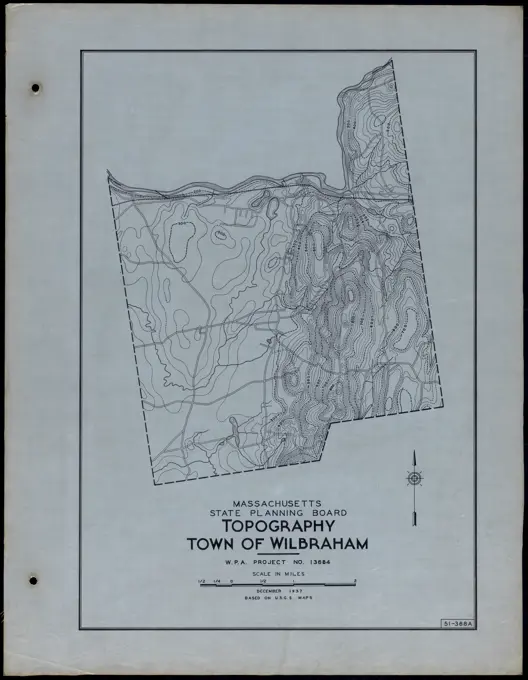
Historic Town Maps of Massachusetts

Detailed maps illustrating the roads and waterways of various Massachusetts towns, featuring intricate line work and labels.

Roads and Waterways Town of Monson. Roads and Waterways Town of Monson
115 assets in this story
6145-50523582
Topography Town of Dudley , Roads, Cities and towns, Land use mapping, Soil mapping, United States. Works Progress Administration, United States. Work Projects Administration. Massachusetts. State Planning Board
6145-50515391
Roads and Buildings Town of Agawam , Roads, Cities and towns, Land use mapping, Soil mapping, United States. Works Progress Administration, United States. Work Projects Administration. Massachusetts. State Planning Board
6145-54373163
Tree Identification - Fir- Red. Photographs Relating to National Forests, Resource Management Practices, Personnel, and Cultural and Economic History
6145-54355548
Forest Insects - General. Photographs Relating to National Forests, Resource Management Practices, Personnel, and Cultural and Economic History
6145-50563335
Roads and Waterways Town of Rowe , Roads, Cities and towns, Land use mapping, Soil mapping, United States. Works Progress Administration, United States. Work Projects Administration. Massachusetts. State Planning Board
6145-50563217
Roads and Buildings Town of Rowe , Roads, Cities and towns, Land use mapping, Soil mapping, United States. Works Progress Administration, United States. Work Projects Administration. Massachusetts. State Planning Board
6145-51388552
Topography Town of Ware , Roads, Cities and towns, Land use mapping, Soil mapping, United States. Works Progress Administration, United States. Work Projects Administration. Massachusetts. State Planning Board
1788-21783381
Topographic map of the Campione d'Italia area, reproduction of documents from the State archive of Como, Lombardy, Italy.
6145-52946698
Yard Survey - Sheet Layout 7/01/1912. Glass Plate Negatives of the Construction and Repair of Buildings, Facilities, and Vessels at the New York Navy Yard.
6145-43809554
Maps, map of drainage areas, Cochituate, Sudbury, Nashua, Assabet, Ware, Swift, Deerfield and Westfield Rivers; and Winnipiseogee and Squam Lakes, Mass., ca. 1894 , waterworks, reservoirs water distribution structures, watershed maps
6145-51388568
Topography Town of Wilbraham , Roads, Cities and towns, Land use mapping, Soil mapping, United States. Works Progress Administration, United States. Work Projects Administration. Massachusetts. State Planning Board
6145-51387043
Roads and Buildings Town of East Longmeadow , Roads, Cities and towns, Land use mapping, Soil mapping, United States. Works Progress Administration, United States. Work Projects Administration. Massachusetts. State Planning Board
6145-50562998
Roads and Buildings City of North Adams , Roads, Cities and towns, Land use mapping, Soil mapping, United States. Works Progress Administration, United States. Work Projects Administration. Massachusetts. State Planning Board
6145-29657125
Collection of the Dutch Heidematschappij. Maps, Haagsche Beemden. undated. Princenhage
6145-51387651
Soil Classification City of North Adams , Roads, Cities and towns, Land use mapping, Soil mapping, United States. Works Progress Administration, United States. Work Projects Administration. Massachusetts. State Planning Board
PREVIOUS
of 2
NEXT
2401 S. Ervay, Suite 206
Dallas, Texas 75215
United States
Get Started
Free ResearchMy BoardsMy Cart
For Creators
How To License Your ContentContributor PortalFrame of Mind
Resources
API accessPricing
Contact
+1 866 236 0087help@viewpictures.co.uk Contact form
©2026 View Pictures. All Rights Reserved. -A
This site is protected by reCAPTCHA and Google Privacy Policy and Terms of Service apply.