My Boards
View Pictures
  • My Boards

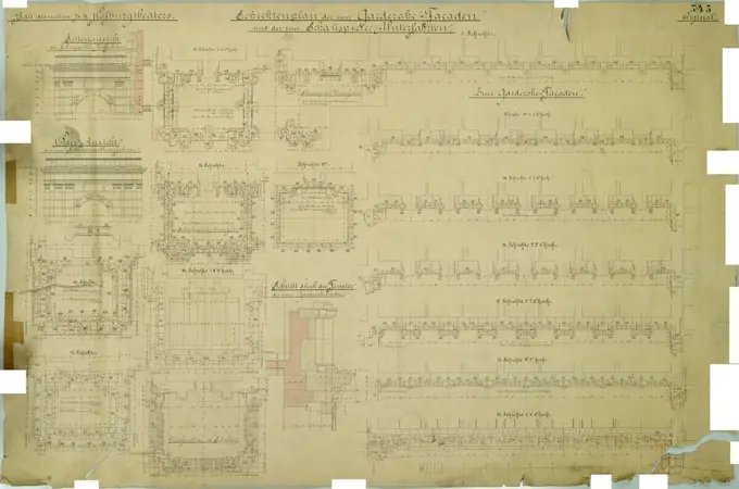
Historical Architectural Plans

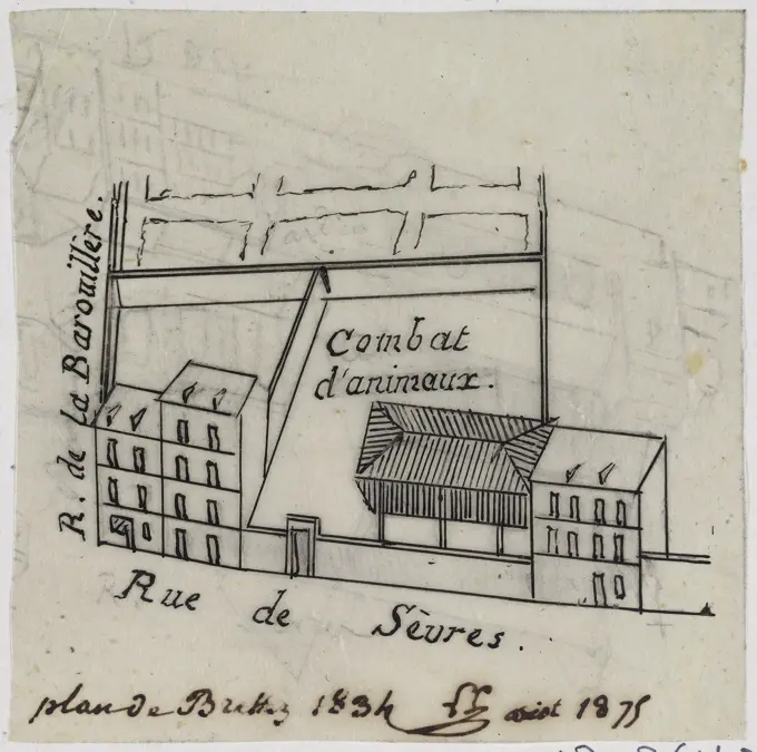
Blueprints and profiles of streets and buildings, showcasing intricate designs and layouts with clean lines and detailed annotations.

Central Park Planning Map No. 22: Bounded by 75th Street, 7th Avenue, 73rd Street and 8th Avenue Cartographic. Maps. 1853. Lionel Pincus and Princess Firyal Map Division. New York (N.Y.), Central Park (New York, N.Y.), City planning
151 assets in this story
6145-59483117
Signature magazine on the occasion of the twenty -five year anniversary of the N.V. Philips light bulb factories, Carel Adolph Lion Cachet, 1916 print Ornament edge with light bulbs. Ten signatures in the middle.  cardboard pen industries. light bulb (electric)
6145-48500204
Booting technology: Rübezahl, Opera House Dresden: Fundrise 3RD scene 7
6145-55954992
Sundry lots on the west side of Great George Street between Spring and Houston Streets 1793. Cartographic. Maps, Surveys, land surveys. Manuscripts and Archives Division
6145-48477443
Rüster Emil (1883-1949), Association of Treasurer in Germany in Berlin-Wilmersdorf (March 17, 1939): New building: Street view 1: 100. Light break on paper, 41.8 x 93.3 cm (including scan edges) Rüster Emil  (1883-1949): Kassenzahnärztliche Vereinigung Deutschlands, Berlin-Wilmersdorf
6145-48654364
Engineering Plans, Wachusett Aqueduct, Open Channel, Lower Dam and Bridge, Sheet No. 1, Southborough, Mass., Dec. 1, 1898 , waterworks, aqueducts, engineering maps
6145-59252284
Sketch of the Lower House of the States General. Extraordinary seat of 1840, 1840 print Map of the Lower House of the States General, during the extraordinary session of 1 August 1840 in connection with the constitutional revisions. On either side an alphabetical name list of the members, ranked at the bottom of the members per province. The Hague paper  plan ~ architecture. Lower House, Parliament, Chamber Courtyard
6145-48981954
Situation of a part of district C, where the broken -down houses of C. van Luin are shown to be found from the Veenstraat to the Nieuwe Kade
6145-48455733
Unknown architect, urban residential building. Monthly competition in July 1879 (07.1879): Grundriss Earth floor, 1st, 2nd (= 3rd) upper floor; Scale bar. Ink and pencil watercolored on the box, 31.4 x 45.4 cm (including scan edges) N.N. : Städtisches Wohnhaus. Monatskonkurrenz Juli 1879
6145-55956700
Real estate map of property bounded by Brook St., Westervalt Avenue, property of J.C. Green and property of the the New Brighton Co. Cartographic. Maps, Cadastral maps. 1890 - 1899. Lionel Pincus and Princess Firyal Map Division. Real property , New York (State) , New York, Staten Island (New York, N.Y.)
6145-52834462
Black and red ink drawing showing the Bühnenhaus of Burgtheater, Vienna I, including side facades, actor underfits, floor plans, recovery, and cut, dated 1879.
6145-51942383
Drawing.Found in office of Marine Museum's curator his linen.
6145-42620599
N.N., Expansion of the Landwehr Canal, Berlin (without dat.): Obere Schleuse to Wendebassin: site plan and cuts 1: 100, 1: 1000. Lithograph on paper, 62.8 x 147.9 cm (including scan edges) N.N. : Erweiterung des Landwehrkanals, Berlin
4443-75470176
Central Park Planning Map No. 19 Bounded by 73rd Street, 7th Avenue, 61st Street, and 8th Avenue, issued in 1853 by the Common Council of New York
6145-30271794
Lupus healing facility, fan cut, Otto Wagner -, artist
6145-43551181
Print (France)
6145-48445002
Barth Erwin (1880-1933), Volkspark Rehberge in Berlin-Wedding (05.1927): Exclusion of the allotment garden system on the Volkspark area in the floor plan with two types of allotments and arterial floor cracks 1:200, stamp. Light break on paper, 52.2 x 65.4 cm (including scan edges) Barth Erwin  (1880-1933): Volkspark Rehberge, Berlin-Wedding
6145-48448539
Jansen Hermann (1869-1945), Building Plan Munich-Hirschau (01.12.1932): Variant 11a: Basic plan 1: 1000, site plan. Coal on transparent, 74.9 x 151.2 cm (including scan edges) Jansen Hermann  (1869-1945): Bebauungsplan München-Hirschau
6145-55956709
Central Park Planning Map No. 19: Bounded by 73rd Street, 7th Avenue, 61st Street and 8th Avenue Cartographic. Maps. 1853. Lionel Pincus and Princess Firyal Map Division. New York (N.Y.), Central Park (New York, N.Y.), City planning
6145-48455016
Unknown architect, blueprint for a settlement of the Abegg Foundation (with a normal home) in Gdansk. Monthly competition June 1877 (06.1877): Riss front view, cross -section; Scale bar, explanatory text. Tusche watercolor on the box, 36.8 x 22.7 cm (including scan edges) N.N. : Bauplan für eine Siedlung der Abegg-Stiftung (mit einem Normal-Wohnhaus), Danzig. Monatskonkurrenz Juni 1877
6145-48502560
test111
6145-43861879
Plan of lots in Cambridge belonging to Dr. John Ware : to be sold by public auction on Tuesday October 11th, at 4 o'clock p.m. on the premises , Real property, Massachusetts, Cambridge, Maps, Cambridge Mass., Maps Norman B. Leventhal Map Center Collection
6145-55916401
Plan of Public Garden : showing proposed arrangement of lots thereon. oriented with north toward the bottom right. Detached from: Report of the Joint Committee on Public Lands in relation to the Public Garden, July, 1850 (City document / Boston (Mass.). City Council ; 1850, no. 18).... , Massachusetts  , Suffolk  ,county   , Boston  , Public Garden  ,park
6145-51839983
Albrecht Dürer, Plan showing how arch was to be assembled, 1515-1517, woodcut on paper.
6145-48503170
Mönnich Rudolf (1854-1922), criminal court and prison of the investigation, Berlin-Moabit. Expansion for investigation (1902-1906): Expansion for investigation in the investigation: floor plan ground floor 1: 100. Lithograph, 131.4 x 93.2 cm (including scan edges)
6145-42603739
Unknown architect, Potsdam town houses. Building recordings (so-called Ziller-Folder) around 1850. Charlottenstraße residential building (built in 1784) (June 18, 1855): Riss front view facade (scale bar). Pencil and ink on paper, 33.4 x 45.8 cm (including scan edges) N.N. : Potsdamer Bürgerhäuser. Bauaufnahmen (sog. Ziller-Mappe) um 1850. Wohnhaus Charlottenstraße 3 (Baujahr 1784)
4443-22034207
French textile manuscript, ca. 1820, ca. 1820, an instruction manual for a school associated with a manufactory begins with a history of silk manufacture and continues with discussion of contemporary silk makers in Spain, Italy and France. The text is illustrated with 136 intricate drawings of looms, many in watercolor, showing set-ups for various patterns and materials, and includes 102 tipped-in examples of fabric. The chapters contain detailed information on silkworms and their breeding, the pulling of silk, and the composition of fashion materials, including gauze and damask.
6145-48446132
Lüdecke Carl Johann Bogislaw (1826-1894), branch of the Prussian Bank, Breslau (07.1874): Base of the right wing: floor plan, tall bar. Ink, ink colored, watercolor on cardboard, 62.1 x 58 cm (including scan edges) Lüdecke Carl Johann Bogislaw  (1826-1894): Filiale der Preußischen Bank, Breslau
6145-42627739
Knoblauch Gustav (1833-1916), teacher seminar, Kyritz: tort, cut, 10 details. Pencil on the box, 35.5 x 52.2 cm (including scan edges)
6145-29913371
Calendar of 1825 (IT)
6145-48448158
Blunck Erich (1872-1950), fallen-like honor in Nikolassee (1920): Detail (without a yardstick): front view, side view, rear view; Text on the front and back; Numbers. Ink and pencil on transparent, 47.5 x 59.5 cm (including scan edges) Blunck Erich  (1872-1950): Gefallenen-Ehrenmal, Berlin-Nikolassee
6145-48503126
Mönnich Rudolf (1854-1922), criminal court and prison of the investigation, Berlin-Moabit. Expansion for an extension of the investigation (1902-1906): Extension construction in the investigation: floor plan 4th upper floor 1: 100. Lithograph, 131.4 x 93.1 cm (including scan edges)
6145-54522658
New York (N.Y.). Croton Aqueduct Department. Cartographic, Maps. 1853. Lionel Pincus and Princess Firyal Map Division. New York (N.Y.), Reservoirs , New York (State) , New York Block No. 573 Map bounded by 89th Street, 5th Avenue, 88th Street, 6th Avenue
6145-55958149
Statistical profile, Erie Canal Enlargement eastern division: commencing in the city of Albany and terminating at Higginsville, Oneida Co. Erie Canal Enlargement eastern division : commencing in the city of Albany and terminating at Higginsville, Oneida Co. Cartographic. Maps. 1851. Lionel Pincus and Princess Firyal Map Division. Canals , New York (State) , Altitudes , Charts, diagrams, etc, Canals , New York (State), Erie Canal (N.Y.), Erie Canal (N.Y.) , Altitudes , Charts, diagrams, etc
6145-46591581
. .
6145-44194267
Different machines
6145-48450524
Havestadt Christian (1852-1908), South Canal for Berlin. Schinkel competition 1878 (1878): Bridge over the channel: longitudinal section (excerpt) with a teaching structure 1:25; Scale bar, explanatory text. Tusche watercolor on the box, 61.2 x 49.5 cm (including scan edges) Havestadt Christian  (1852-1908): Südkanal für Berlin. Schinkelwettbewerb 1878
6145-55927214
New York (N.Y.). Croton Aqueduct Department. Cartographic, Maps. 1853. Lionel Pincus and Princess Firyal Map Division. New York (N.Y.), Reservoirs , New York (State) , New York Block No. 574 Map bounded by 90th Street, 5th Avenue, 89th Street, 6th Avenue
4409-48155611
Floor plan and sections through the slave ship Brooks or Brookes of Liverpool. Carried 351 men, 127 women, 90 boys and 41 girls, total of 609 slaves and 45 sailors. Lower deck with chained males a, boys b and girls c. The Slave Ship. After the engraving published by the Society for Effecting the Abolition of the Slave Trade, Plymouth, 1788. Handcoloured copperplate engraving from Frederic Shoberls The World in Miniature: Africa, A description of the manners and customs Moors of the Sahara and of the Negro Nations, R. Ackermann, England, 1821.
4443-19589118
Artist: William F. Barker, Plan of the City ofPhiladelphia, ca.1800, Line engraving, black and white, sheet: 40 × 48 cm (15 3/4 × 18 7/8in.), Made in United States, American, 19thcentury, Works on Paper -Prints
4409-17401827
Cross-sections, which show the different aspects of the buildings shown in the plan of Pompeii the preceding plate, from Antiquités de Pompeïa, tome premier, Antiquités de la Grande Grèce... (Antiquities of Pompeii, volume one, Antiquities of Great Greece...), volume 1, plate 3. Artist: Francesco Piranesi (Italian, Rome 1758-1810 Paris); After Giovanni Battista Piranesi (Italian, Mogliano Veneto 1720-1778 Rome). Dimensions: Sheet: 21 7/8 x 31 9/16 in. (55.5 x 80.2 cm)Plate: 21 7/8 x 30 11/16 in. (55.5 x 78 cm). Series/Portfolio: Antiquités de Pompeïa, tome premier, Antiquités de la Grande Grèce, aujourd'hui Royaume de Naples, Gravées par Francois Piranesi, Membre de l'Académie de Stockolm, et Ancien Ministre de la Cour de Suède a celle de Rome d'après les Dessins Originaux et les Observations Locales du feu Célébre Architete, Peintre, Sculpteur, Greveur, Le Chev.er Jean-Baptise Piranesi; rédigées et expliqués par Antoine-Joseph Guattani. Date: 1804. Museum: Metropolitan Museum of Ar
6145-30094559
Watering at Millingen, 1809.broken Dike at Millingen During the Flood in Gelderland in January 1809. With Different Inscriptions in the Performance.
6145-55955948
Map of 26 lots of ground in the 11th & 13th wards of the city of New-York, belonging to the Fulton Bank, to be sold at auction by James Bleecker & Sons on Wednesday, Jany. 15th, 1834, at the Merchts' Exchange Cartographic. Cadastral maps, Maps. 1834. Lionel Pincus and Princess Firyal Map Division. United States , New York (State) , New York, Landowners , New York (State) , New York, Real property , New York (State) , New York, Real propery auctions , New York (State) , New York, Manhattan (New York, N.Y.), Lower East Side (New York, N.Y.)
6145-48442757
Barth Erwin (1880-1933), Osterholzer Friedhof in Bremen (1910): Floor plan of the overall system 1: 1000, legend to the grave depths. Ink, pencil, ink colored on transparent, 73.1 x 151.9 cm (including scan edges) Barth Erwin  (1880-1933): Osterholzer Friedhof, Bremen
6145-59588627
Two faces on the interior of the Library in Wolfenbüttel, Caspar Merian, After Conrad Buno, 1654 print   paper etching / engraving public library. globe. writing-table, writing-desk Wolfenbüttel
6145-46591595
. .
6145-55927201
New York (N.Y.). Croton Aqueduct Department. Cartographic, Maps. 1853. Lionel Pincus and Princess Firyal Map Division. New York (N.Y.), Reservoirs , New York (State) , New York Block No. 578 Map bounded by 94th Street, 5th Avenue, 93th Street, 6th Avenue
6145-48488671
N.N., Königsberger Seekanal. Boat passage with a dam head and gas fire, dedication: site plan 1: 2000, cuts 1:50. Lithograph on paper, 32.9 x 49.1 cm (including scan edges)
6145-52505319
The plan of Babylon still image. Site plans. 1808. The Miriam and Ira D. Wallach Division of Art, Prints and Photographs: Picture Collection. Babylon (Extinct city)
6145-50630837
Left bank n ° 7: animal fight. Rue de Sèvres. Plan of Brettez 1834. Leon SYMONNEYE (1803-1879). Left Bank N ° 7: Animal Combat. Rue de Sèvres. Plan of Bretz 1834. Brown ink. August 1875.
6145-42627306
N.N., Road Bridge over the Sauer, Wasserbillig: site plan 1: 1000, view 1: 100. Lithograph colored on the cardboard, 46.3 x 105 cm (including scan edges)
6145-48503042
Gustav Runge (1822-1900): public resignation. Monthly competition March 1847
PREVIOUS
of 2
NEXT
2401 S. Ervay, Suite 206
Dallas, Texas 75215
United States
Get Started
Free ResearchMy BoardsMy Cart
For Creators
How To License Your ContentContributor PortalFrame of Mind
Resources
API accessPricing
Contact
+1 866 236 0087help@viewpictures.co.uk Contact form
©2026 View Pictures. All Rights Reserved. -A
This site is protected by reCAPTCHA and Google Privacy Policy and Terms of Service apply.