My Boards
View Pictures
  • My Boards
← Documents & Records

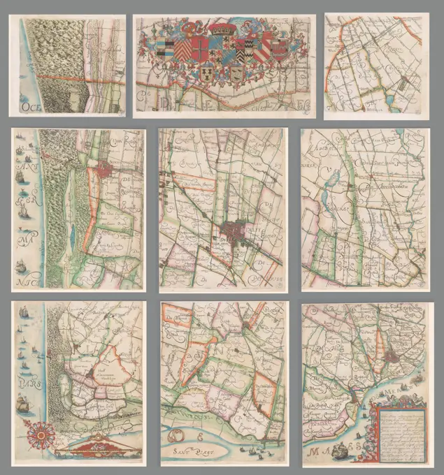
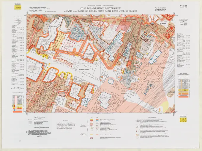
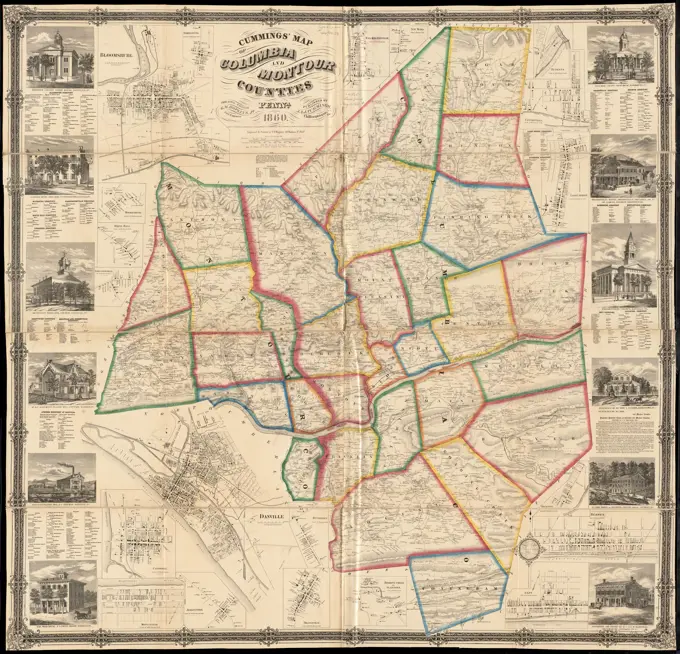
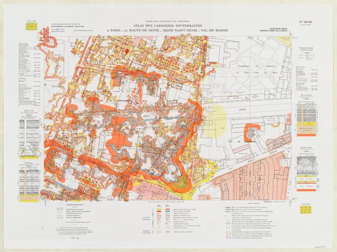
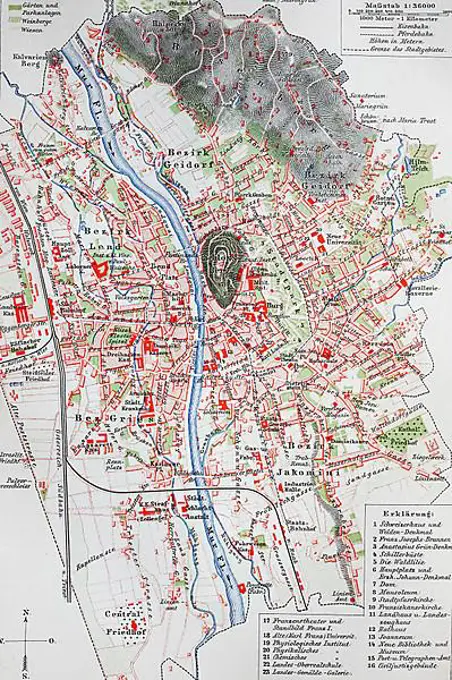
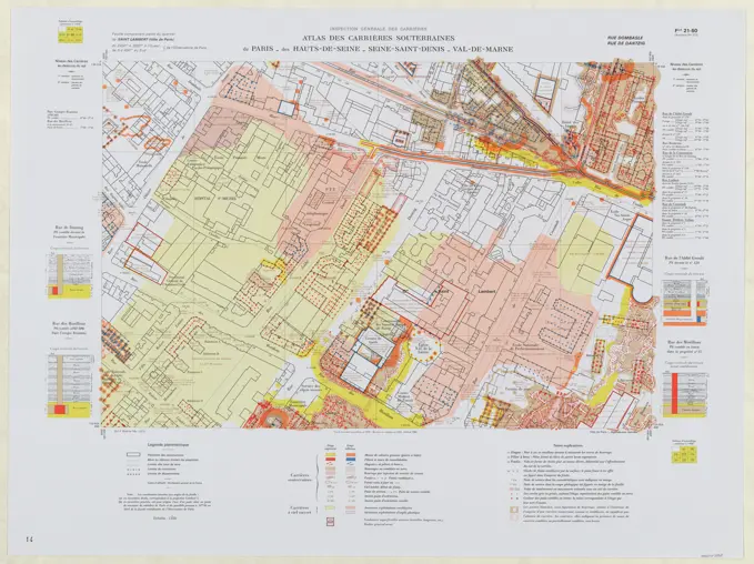
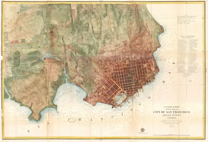
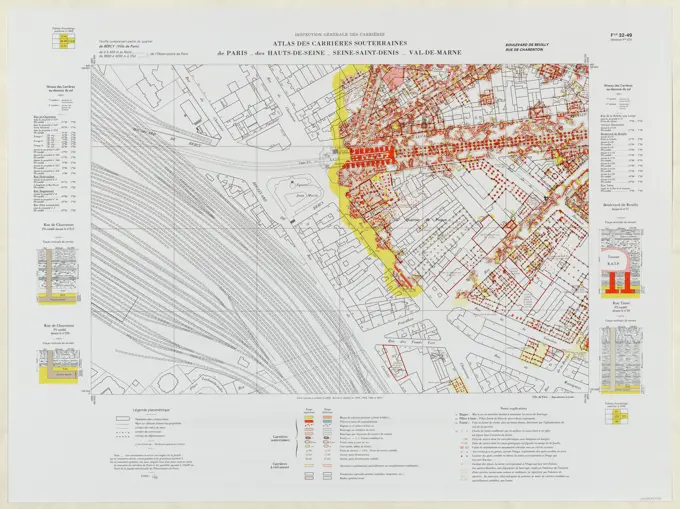
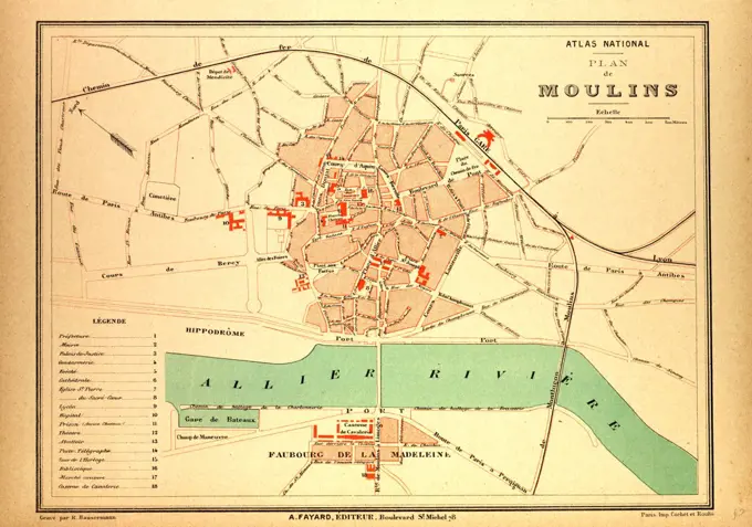
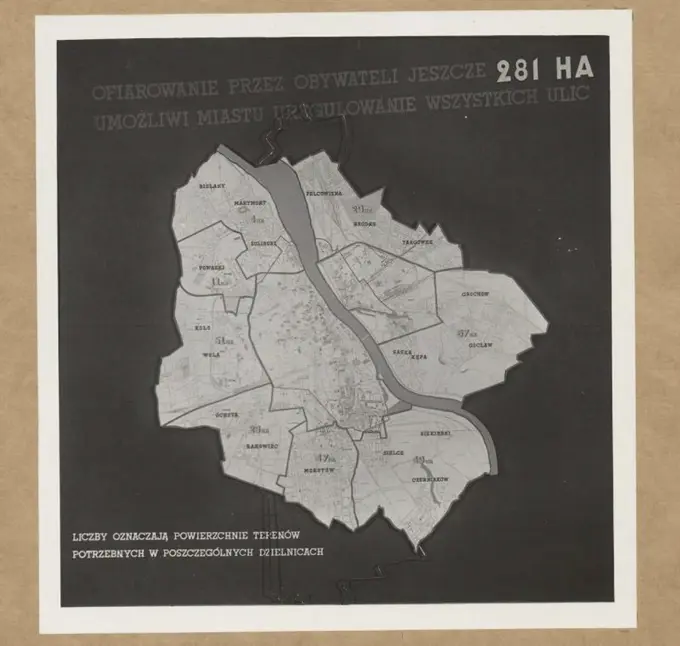
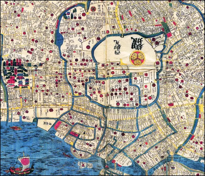
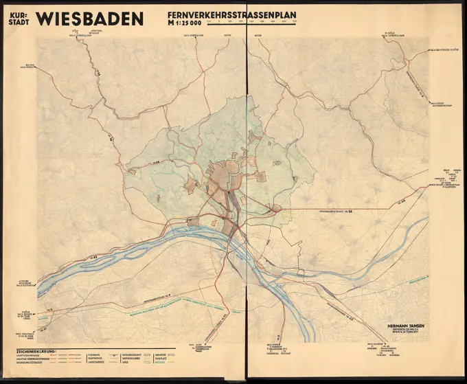
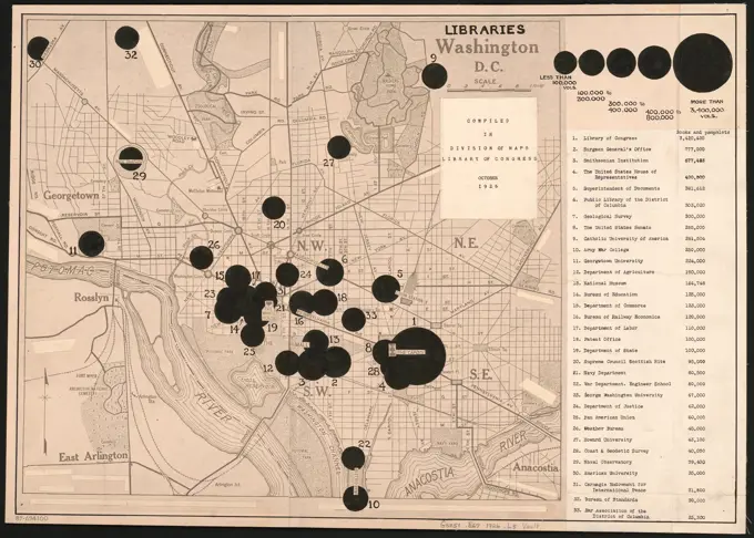
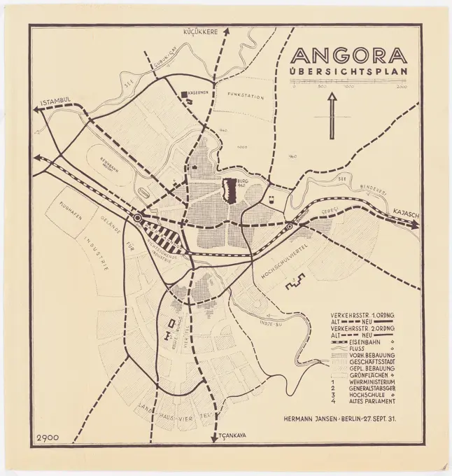
Historical City Maps

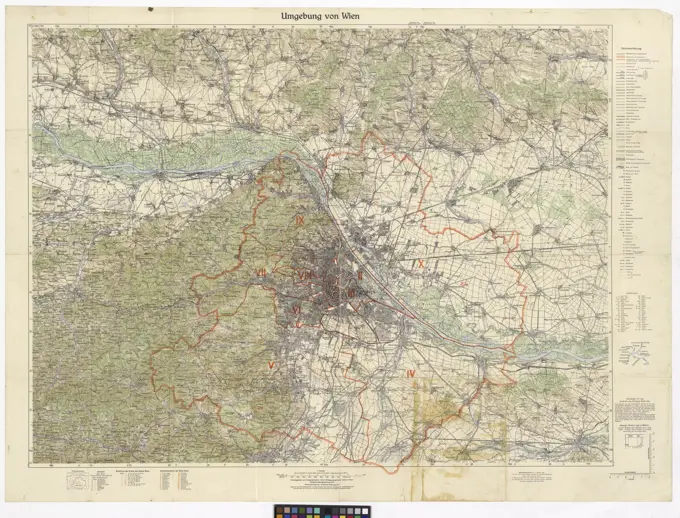
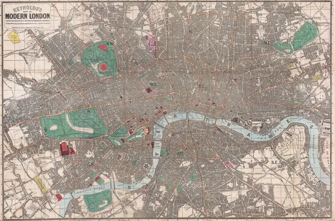
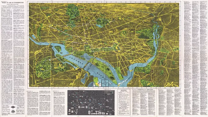
Collection of detailed, vintage maps showcasing cities like Paris, Brockton, Dublin, and Vienna with street layouts and notable landmarks.

Elihu Geer sons' new map of the city of Hartford, Connecticut , Hartford Conn., Maps Norman B. Leventhal Map Center Collection
268 assets in this story
6145-51395287
Map showing metropolitan sewerage district : January 1, 1910 , Boston Metropolitan Area Mass., Maps, Sewerage, Massachusetts, Boston Metropolitan Area, Maps, Sanitary districts, Massachusetts, Boston Metropolitan Area, Maps Norman B. Leventhal Map Center Collection
6176-67077189
'Plymouth', c20th Century. Artist: John Bartholomew.
6145-59569005
Map of the Delfland Water Board, consisting of nine parts, Floris Balthasarsz. Van Berckenrode, 1611 - 1692 print In the middle of the weapons of the members of the Delfland Water Board. Bottom left a bowl: 1600 rods.  paper etching / engraving maps of separate countries or regions. armorial bearing, heraldry Delfland
6145-48719625
Plan of modern Rome , Rome Italy, Maps Norman B. Leventhal Map Center Collection
6145-29929752
St. Lambert and Necker neighborhoods (Paris City) / Leaf 22-50 (old leaf 278)
6145-55913376
Cummings' map of Columbia and Montour counties, Penn'a : from actual surveys. General-content county map showing townships, rural buildings, and householders' names; the borough insets show real-property tracts (lots), building coverage, and owners' names. Hand colored to emphasize township boundaries, township areas, and boroughs. Distances between road junctions are shown in perches. Relief shown by hachures. "Entered according to act of Congress in the year 1860 by J.A.J. Cummings in the ... Eastern District of Penn'a." Originally printed on 4 sheets (later conjoined). Includes text, note, local business directories, and illustrations of prominent buildings. Borough/village insets: Bloomsburg -- Rohrsburg -- Washingtonville -- New Media -- Ruperts -- Centreville -- Light Street -- Benton -- Berwick -- Espy -- Roaring Creek or Slabtown -- Orangeville -- Buckhorn -- Danville -- Jerseytown -- Mifflinville -- Catawissa -- Limestoneville -- White Hall -- Mooresburg... Map of Columbia and
6145-50568591
Massachusetts Bay Transportation Authority system route map , Local transit, Massachusetts, Boston, Maps, Boston Mass., Maps, Massachusetts Bay Transportation Authority Norman B. Leventhal Map Center Collection
6145-29622314
Collection of the Dutch Heidematschappij. Map of Arnhem 1: 10000 (ca. 1950). undated. Arnhem
6145-29929754
The districts Montparnasse and Croulebarbe (city of Paris) / sheet 26-50 (old leaf 282)
1848-50242594
City map, 1892, Graz, Austria, digitally restored reproduction of an original 19th-century original, Europe
6145-54524485
Cartographic, Maps. 1884 - 1936. Lionel Pincus and Princess Firyal Map Division. Fire insurance , New York (State), Real property , New York (State), Cities & towns , New York (State) Queens V. 5, Plate No. 15 Map bounded by Ave. G, N. 13th St., 1st Ave., West Blvd.
6145-29929730
The Saint Lambert district (city of Paris) / Leaf 21-50 (old leaf 277)
6145-50568616
Pascoe's London and its environs, drawn from the latest surveys , London England, Maps Norman B. Leventhal Map Center Collection
1848-50242597
City map, 1892: Breslau, now Wroclaw, Poland, digitally restored reproduction of an original 19th-century map, Europe
6145-55913231
Clue plan for Collins' illustrated guide to London. Relief shown by hachures.... , England  , London
1848-61284447
Historical map of Frankfurt am Main, Hesse, Germany, 1890, Europe
6145-51427447
Deaths / on / tuberculosis / in the years / 1912-1918
6145-29095052
1858 U.S. Coast Survey Chart or Map of San Francisco, Califorina
1848-54692115
Map of Venice, from Meyers Konversationslexikon encyclopedia, 1897
6145-29929747
The Bercy / Leaf 42-49 district (old leaf 272)
6145-30282967
Surroundings of Vienna , Environment of Vienna  Groß-Wien with district division, Cartographic formerly military geographic institute in Vienna, editor
6145-48484540
N.N., Map of Hafen Harburg and the surrounding area (without date): map. Print colored on paper, 75.2 x 50.2 cm (including scan edges) N.N. : Karte Hafen Hamburg-Harburg und Umgebung
6145-51398399
Plan for Boston , Buildings, Massachusetts, Boston, Maps, Zoning, Massachusetts, Boston, Maps, Central business districts, Massachusetts, Boston, Maps, City planning, Massachusetts, Boston, Maps, Buildings, Height restrictions, Massachusetts, Boston, Maps, Land use, Massachusetts, Boston, Maps
6145-30260701
Wall plan of the postal order districts of Vienna, Verlag G, Freytag , Berndt, later Kartogr, Institution G, Freytag , Berndt -, publishing house
6145-29929591
Career Branch of the Seine / Atlas of Underground Careers of Paris / Assembly Table / 1946
6145-55916948
R.L. Polk & Co's map of greater Battle Creek and suburbs. Includes index, red overprint advertising Wheelock-Prestler Rfg. & Const. Co., and circles showing radial distance. "In connection with the Battle Creek Directory drawn & compiled by A.H. Chase, C.E.".. Greater Battle Creek and suburbs. Greater Battle Creek and suburbs, Michigan  , Calhoun  ,county   , Battle Creek
6145-45677187
Plan of the siege of Lille, 1708; Plan De La Ville et Citadelle De Lille Assiege Par les Alliez. Le 22e. D'Aoust 1708. Map of Rijssel (Lille), Bestzicht from August 22, 1708 by the Allies under Prince Eugenius of Savoy and Prince Johan Willem Friso. At the top right a bet with a map of the larger area.
6145-48718701
Boston Elevated Railway lines operated 1925 , Local transit, Massachusetts, Boston, Maps, Railroads, elevated, Massachusetts, Boston, Maps, Subways, Massachusetts, Boston, Maps, Bus rapid transit, Massachusetts, Boston, Maps, Boston Mass., Maps, Boston Elevated Railway Company Norman B. Leventhal Map Center Collection
6145-29095201
1862 Reynolds Pocket Map of London, England
1848-50242581
City map, 1892, Dresden, Germany, Germany, digitally restored reproduction of an original 19th century map, Europe
6145-55916124
Plan de Paris divise en 20 arrondissements et 80 quartiers. Date of publication estimated from subway system. Indicates street address numbers at corners. Attached to inside front cover of accompanying text is a map titled "Metropolitain" showing the subway system... Paris au 1/17.500eme en 8 couleurs Trace complet des rue de Paris et du metropolitain. Paris au 1/17.500eme en 8 couleurs Trace complet des rue de Paris et du metropolitain, France  , Île-de-France  ,region   , Paris
6145-30267277
Plan of the Reichshaupt and Residenzstadt Vienna, reproduction, After, Verlag G, Freytag , Berndt, later Kartogr, Institution G, Freytag , Berndt -, publishing house
6145-50567251
The Matthews-Northrup up-to-date map of Buffalo and Towns of Tonawanda, Amherst, Cheektowaga and West Seneca , Buffalo N.Y., Maps, Amherst N.Y., Maps, Cheektowaga N.Y., Maps, West Seneca N.Y., Maps, North Tonawanda N.Y., Maps Norman B. Leventhal Map Center Collection
6145-50571898
The Builder map of the county of London : shewing the boundaries of the surveyors' districts under the building acts , Zoning, England, London, Maps, London England, Maps Norman B. Leventhal Map Center Collection
4443-11166
MAP OF ANGOUL_ME, FRANCE
6176-66094137
1922 Map of Beirut, Lebanon.  Produce by French Military Services.
6145-59604386
Reproduction of a map of Amsterdam with the counting of the vacant houses in the city, Anonymous, in or after 1912 photomechanical print At the top: municipal construction and housing supervision. Belongs to Annex I.  paper photolithography maps of cities Amsterdam
6145-55915041
Map of the town of Natick Middlesex Co. Mass : from actual surveys. Relief shown by hachures. Insets: Felchville, Natick (town center), and South natick. Entered according to act of Congress A.D. 1874 by J.B. Beers & Co. in the office of the Librarian of Congress at Washington.... , Massachusetts  , Middlesex  ,county   , Natick
6145-51392581
Density of population in greater Tokyo - census of 1926 , Tokyo Japan, Population, Maps Norman B. Leventhal Map Center Collection
6145-29658391
Collection of the Dutch Heidematschappij. Water boards, overview cards, Barneveld Beek. undated. Barneveldse Beek
6145-30309106
Overall plan of Vienna with an adjoining map of the city center including sights, Verlag G, Freytag , Berndt, later Kartogr, Institution G, Freytag , Berndt -, publishing house
6145-29095839
1938 Pictorial Map of Washington D.C.
6176-65988516
Map of the Cities of Manchester and Salford. Late 19th century. Black and White Illustration from Our Own Country Vol III published by Cassell, Petter, Galpin & Co. in the late 19th century.
6176-66094052
montreal tram route maps late 1940s
4443-11179
MAP OF MOULINS, FRANCE
6145-50661189
Flat land of the city of Utrecht.
6145-30309108
Plan from Vienna, Cartographic formerly military geographic institute in Vienna, editor
6145-50444391
Jansen Hermann (1869-1945), total development plan Ankara (1928-1928): basic plan in two parts, part B (southern part) 1: 4000. Ink, pencil on transparent, 111.4 x 181.7 cm (including scan edges) Jansen Hermann  (1869-1945): Gesamtbebauungsplan Ankara
6145-43578942
National Museum of Warsaw. The exhibition 'Warsaw yesterday, today, tomorrow' (13 X 1938-30 IV 1939). Hall no. 10. `The urban development of the city, area policy and transport conditions` - table `With the citizens giving 281 hectares more to the city, i. Plater-Zyberk, Stefan (1891-1943), photographer
6145-55920622
Correct Plan of the Cities of London and Westminster and Borough of Southwark, including the Bills of Mortality with the Additional Buildings. Original caption: Correct PLAN of the CITIES of LONDON & WESTMINSTER & BOROUGH OF SOUTHWARK, including the BILLS of MORTALITY, with the ADDITIONAL BUILDINGS &c. Engraved from a New Survey for the London Magazine 1761. The London Magazine of Gentlemen's Monthly Intelligencer, p. 289 Vol. 30. 1761. Size: 15 3/4 x 8 3/4 inches inside to inside. State: England Place: London.
1848-53923565
Map of Aachen, an illustration from Meyers Konversations-Lexikon, an encyclopedia from 1897
6145-55913473
District within fire limit of Tokyo - 1928. Part of a collection of 7 maps of Tokyo. Translated title, legend and some place names handwritten in ink. Conservation of this piece was funded by Arend Sluis and Mark Mulligan.... , Japan  , Tokyo
1525-28026743
Map of Paris under Henri IV and Paris in the advent of Louis XIV, vintage engraved illustration. Dictionary of words and things - Larive and Fleury - 1895.
6145-50444392
Jansen Hermann (1869-1945), total development plan Ankara (1928-1928): Basic plan 1: 4000. Pressure on paper, 214.7 x 187.1 cm (including scan edges) Jansen Hermann  (1869-1945): Gesamtbebauungsplan Ankara
6145-29658502
Collection of the Dutch Heidematschappij. Exchange graves, overview cards. undated. Moergestel
4443-11174
MAP OF CONSTANTINE, FRANCE
6176-66916547
Robinson's aeroplane map of Sydney, Australia 1922
6145-48719741
Spartanburg, South Carolina : the city of success ; city map and street directory , Spartanburg S.C., Maps Norman B. Leventhal Map Center Collection
4443-11162
MAP OF ORAN, FRANCE
6145-48448805
Jansen Hermann (1869-1945), development plan of the city expansion Izmir. Northern city expansion (1932-1932): Require of an older proposal: basic plan 1: 2500, scale bar. Ink on transparent, 78.3 x 107 cm (including scan edges) Jansen Hermann  (1869-1945): Bebauungsplan der Stadterweiterung Izmir. Nördliche Stadterweiterung
6176-66094505
Vintage Geographic Map for the city of Bergen, Norway, 1885
1899-18792918
Edo (戸, literally 'bay-entrance' or 'estuary'), also romanized as Yedo or Yeddo, is the former name of the Japanese capital Tokyo, and was the seat of power for the Tokugawa shogunate which ruled Japan from 1603 to 1868. During this period it grew to become one of the largest cities in the world and the site of a vibrant urban culture centered on notions of the 'floating world'.
6145-55956735
Map of the country thirty three miles around the city of New York Cartographic. Maps. 1873. Lionel Pincus and Princess Firyal Map Division. New York Metropolitan Area , Maps
6145-50444178
Jansen Hermann (1869-1945), Wiesbaden (09/09/1931): Transport and zone plan via measuring table card 1: 25000. Photo watercolor on cardboard, 141.5 x 172 cm (including scan edges) Jansen Hermann  (1869-1945): Wiesbaden
6239-70845525
Libraries, Washington D.C.  | Library of Congress
6145-50444297
Jansen Hermann (1869-1945), total development plan Ankara (27.09.1931): Transport and land use plan, first version, 1:20 000. Break on paper, 45.4 x 43.2 cm (incl. Scan edges) Jansen Hermann  (1869-1945): Gesamtbebauungsplan Ankara
6145-59000283
Anonymous. Plan of Paris from the Revolution to the Second Republic, 1789-1851. Ink, gouache and cork on agglomerated wood. Paris, Carnavalet museum. Geographical map, second republic, geography, revolutionary period, Paris plan, French revolution, second republic, urban
6145-55916608
Planta geral da cidade de Sao Paulo com indicacoes diversas. Includes statistics and index.... , Brazil  , São Paulo  , San Paolo
PREVIOUS
of 3
NEXT
2401 S. Ervay, Suite 206
Dallas, Texas 75215
United States
Get Started
Free ResearchMy BoardsMy Cart
For Creators
How To License Your ContentContributor PortalFrame of Mind
Resources
API accessPricing
Contact
+1 866 236 0087help@viewpictures.co.uk Contact form
©2026 View Pictures. All Rights Reserved. -A
This site is protected by reCAPTCHA and Google Privacy Policy and Terms of Service apply.