My Boards
View Pictures
  • My Boards
← Documents & Records

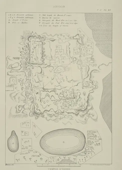
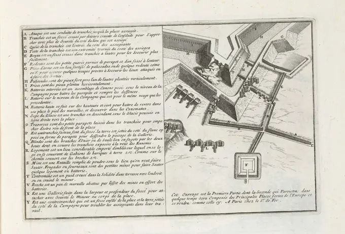
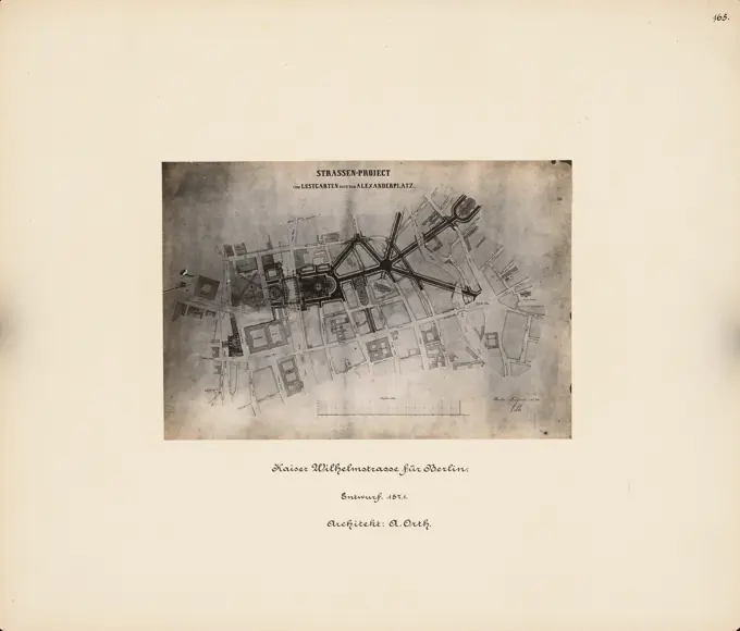
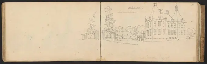
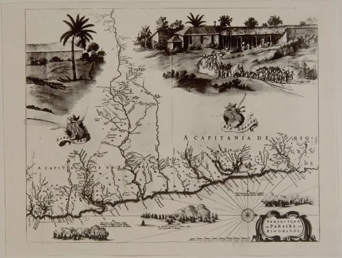
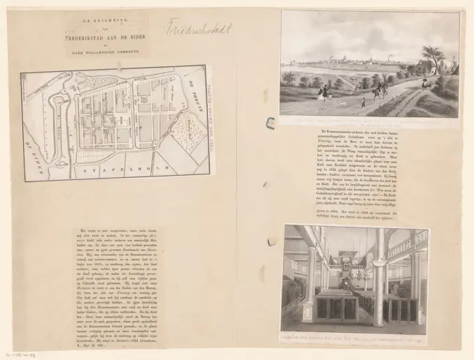
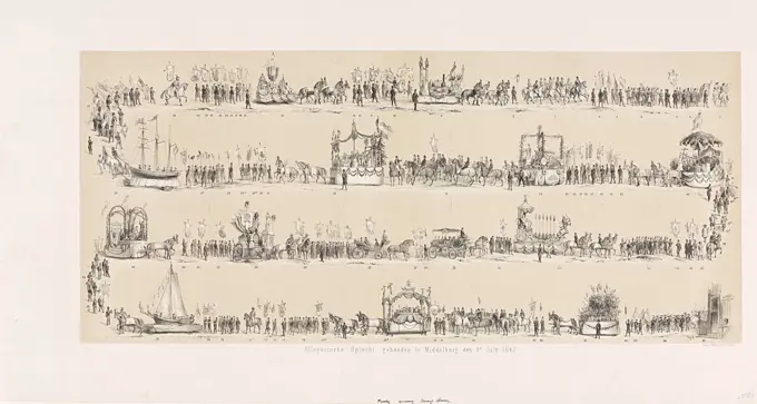
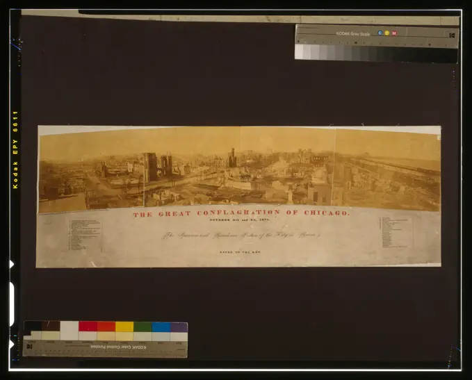
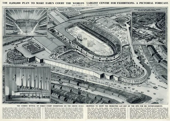
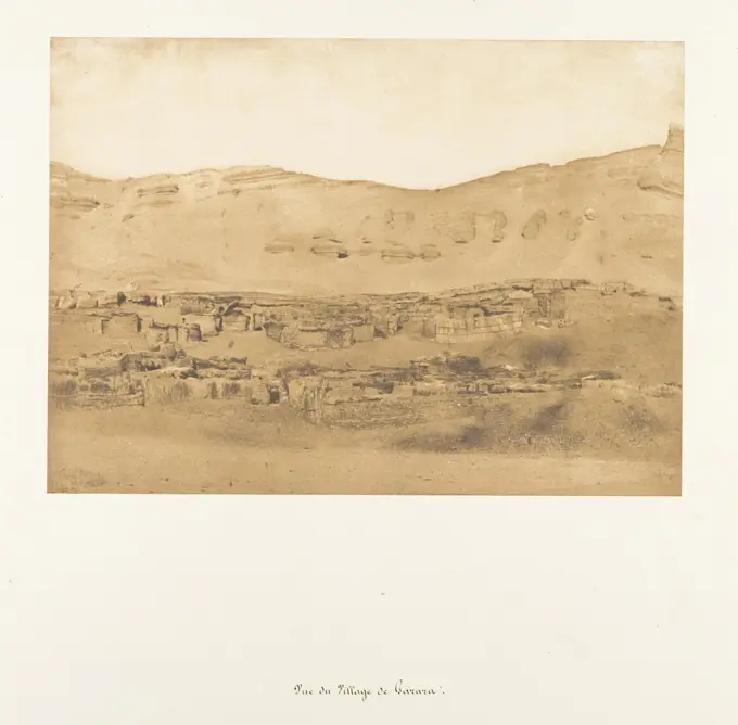
Historical City Maps and Sketches

Collection of historical sketches and maps depicting various cities, including detailed renderings and topographical representations, showcasing urban landscapes and architectural features.

Map of the Landerijen in Buitenveldert in Amsterdam, Anonymous, 1767 print  Amsterdam paper etching maps of separate countries or regions Buitenveldert
Map of the Landerijen in Buitenveldert in Amsterdam, Anonymous, 1767 print Amsterdam paper etching maps of separate countries or regions Buitenveldert
163 assets in this story
6145-59597345
Fortress map of Philippeville, Anonymous, 1721 - 1774 print Fortress map of Philippeville. At the bottom right the title cartouche with a bowl for the map at the bottom: Echelle de 200 toises. At the bottom of the map a cross -section of one of the fortifications (a casemate) from Philippeville. Bottom left a frame with legend A-V. Above a map of the 'Bastion Dauphin', with a corresponding scale below: Echelle de 50 Toises.  paper etching / engraving maps of cities. fortified city Philippeville
4443-75477131
Abydos, Temple of Osiris, 1869 - 1880. Published by Imprimerie nationale in Paris. The image relates to excavations in Abydos, an extinct city in Egypt, and features inscriptions and lithographs associated with Egyptian archaeology
6145-45951899
Map of Dam Square with the positions of the shooters, 28 June 1748; Plan Van Den Dam in Amsterdam, with the promotion of the Posters of the Burger Compagnien, den 28 Juny. 1748. Map of Dam Dam in Amsterdam and surroundings with the positions of the companies shooters who had to maintain the order on 28 June 1748 during the executions of two participants in the tenant rosis on 28 June 1748. Under the legend A-l.
6145-59365546
Aerial photo of Sèvres and the road to Versailles, Paul Nadar, 1886 photomechanical print   paper  city-view in general; 'veduta' Sèvres. Versailles
6145-30264668
Base Risplan of the City of Vienna with the Glacis and adjacent parts of the suburbs in nine leaves, Werner Arnold Steinhausen -, cartographer
6145-48483400
Nimmann Fritz, plan of a garden (09.08.1919): floor plan, scale 1: 200. Ink on paper, 68.8 x 49.7 cm (including scan edges) Nimmann Fritz : Plan einer Gartenanlage
6145-54548841
Kingstone. Cartographic. Maps. 1843. Lionel Pincus and Princess Firyal Map Division. Fortification , New York (State) , Kingston, Kingston (N.Y.) , Maps
6145-30306776
Model of the so -called large settlement on the Eichkogel also wooden levy settlement
6145-29929479
Map of the market of La Villette
6145-59252066
Fort Liefkenshoek, 1832, 1832 - 1833 print Plan of Fort Liefkenshoek, located on the Scheldt opposite Fort Lillo. In connection with the siege of the Citadel of Antwerp by the French army, December 1832. At the bottom of the Legenda A-G. print maker: Netherlandsprinter: Utrecht paper  fortress Scheldt. Fort Liefkenshoek
6145-59017011
Bernard and Cie. "Competition for the 1900 Universal Exhibition. Projects exhibited at the Palais de l'Industrie (volume of boards)". Half-cooker and flat binding with jasper decor. Back to nerves. 1895. Museum of Fine Arts of the City of Paris, Petit Palais. 102006-9 Contest, Decor Jaspe, Detail, Study, Universal International Exhibition of 1900, Palace of Industry, Plan, Plate, Project, Technical Review, General view, 19th XIX 19th 19th 19th century
4443-73238503
Northern Netherlands, Image of the Solemn Funeral on 15 May 1787. in Dordrecht of Mr. and Mrs. Cornelis Goverd Visser, Funeral of Cornelis Govert Visscher, 1787, verso - stamped, commander of the Utrecht citizen company Turkey, killed in the battle at Vreeswijk on 9 May, in Utrecht on 15 May 1787. Funeral procession in three rows. On the sheet under the plate the legend 1-20 of the participants in the procession., print, prent, prints, prenten, Frederik Muller Historieplaten, height 372 mm, width 382 mm, print maker, prentmaker, 1787 - 1787, paper, papier, etching, etsen
6145-30116747
Achtste Plaat TEKST in Loopgraven Bij Een Bastion, 1693; The forces of Europe, or description of the main cities, with their fortifications: designed by the best ingenieurs, particularly those (...) of France, whose plans have been lift by M. de Vauban.ight Flat with Text and trenches at a bastion. Part of the First Part (1693) of the Picture in Which Bundles are The Eight Parts of the Forces of Europe Issued Between 1693-1697. The Printing Works Consistencuts of 175 Flat Plans (from Sebastien Le Preterre, Lord of Vauban) from Renownedred Strong Cities and Fortresses in the Nine-Year War. Title in french.
6145-59213257
Map of a chapel in Veere, Jacob Schwartzenbach, 1790 print Map of the chapel, which was dug up in 1720 on the Kapellestraat in Veere, with the scale. Below that on a sign that stands against a tree trunk a ten -line inscription in Dutch. Veere paper etching plan ~ architecture
6145-29940417
Leaf 20 / Prussian works between Choisy Le King and Thiais./village of Thiais. (December 1870)
6145-48474899
Orth August (1828-1901), breakthrough of the Kaiser-Wilhelm-Straße in Berlin (1871): site plan. Photo on cardboard, 33.5 x 39.2 cm (including scan edges) Orth August  (1828-1901): Durchbruch der Kaiser-Wilhelm-Straße, Berlin
6145-59595678
Fortress map of Oostburg, Anonymous, 1652 print Above, to the right of the middle the title. At the bottom right a bowl: 80 virgae rods. On Verso Dutch text.  paper etching / engraving / letterpress printing maps of cities. fortified city Oostburg
6145-54523644
Cartographic, Maps. 1884 - 1936. Lionel Pincus and Princess Firyal Map Division. Fire insurance , New York (State), Real property , New York (State), Cities & towns , New York (State) Brooklyn V. 4, Plate No. 2 Map bounded by East River, N. 9th St., Kent Ave., N. 6th St.
6145-59585223
Map of IJlst, Anonymous, 1550 - 1650 print Map of IJlst in a nutshell perspective. At the top left, a man and a woman at the bottom right.  paper etching maps of cities. folk costume, regional costume Friesland. IJLST
6145-59707629
Second image of some of the main events of the House of Orange, 1761 - 1804 print Leaf with 4 performances of historical scenes. The installation of Willem V to Knight of the Order of the Garter Band, 5 June 1752; The marriage of Princess Carolina with the Prince of Nassau-Weilburg, March 5, 1760; The death of Anna van Hannover, 12 Janurai 1759; The marriage of Willem V to Wilhelmina van Pruisen, 5 October 1767. A caption under each performance. Numbered at the top right: No. 99. Amsterdam paper letterpress printing
6145-45674693
Siege from Ostend, 1601-1604; The investment of Ostend in the Jaeren MDCI, MDCII, MDCIII and MDCIV. Siege from Ostend. Map of the defense and attack lines around the city and in the surrounding area, left the quarter of Spinola, the quarter of Aartshertog Albrecht quarter. At the bottom of two cartouches with the title and the legendas A-R and 1-34. At the top left a bet with a city map in 1641.
4443-21171112
THE OPENING OF THE INTERNATIONAL EXHIBITION OF NAVIGATION AND MANUFACTURES BY THE QUEEN AT LIVERPOOL, UK, 1886: BIRD'S-EYE VIEW OF LIVERPOOL, SHOWING THE ROUTE OF THE ROYAL PROCESSION FROM NEWSHAM HOUSE TO THE EXHIBITION AND THROUGH THE CITY
6145-30077546
GENERAL PLAN OF BUILDINGS, POURS GARDENS TERRASSES AND DEPENDENCES OF NEW WATERS OF PASSY General plan of buildings, courses, gardens, terraces and dependencies of the new waters of Passy belonging to the Veillard (1790). Photograph of Charles Lansiaux (1855-1939), 1920.
4409-17282494
LA ESPAÑOLA. Author: MARTIN WALDSEEMÜLLER (1470-1520) IIACOMINUS. Location: BIBLIOTECA NACIONAL-COLECCION. MADRID. SPAIN.
6145-30102453
Twee marktkramen.Two market stalls opposite each other. Leaf 34a verso from a sketchbook with 52 magazines manufactured in the area of Kampen, Hattem, Hoorn and Zwolle.
6145-30109657
Kasteel Staverden at Ermelo.Leaf 19 Verso and 20 Recto from a Sketchbook with 51 Sheets.
6145-59236834
The animal enclosures of the King of Tuban, 1599, 1619 print The animal enclosures of the Javanese king of Tuban, January 1599. Storage space for luggage and the animal enclosures for roosters, pagegies and dogs. Part of the illustrations in the travelogue from the Second Schipvaart to the East Indies under Jacob Cornelisz. van Nes and Wijbrant van Warwyck in 1598-1600. No. 6. Northern Netherlands paper engraving exploration, expedition, voyage of discovery. landscapes in tropical and sub-tropical regions
6145-29650566
Poll photo collection. Jerusalem in art. Print representing the city of Jerusalem. 1953-00-00}. Israel, Jerusalem, Jordan
6145-59252431
Funeral procession of King William I, 1844 (plate 1), 1844 print Funeral procession of the former King William I in Delft on January 2, 1844. The whole procession depicted in three consecutive plates, first album with the numbers 1-7. print maker: Netherlandsprinter: Netherlandspublisher: The Hague paper  cortege, funeral procession Delft
6145-59618449
Photo production of a map of the slaughter area in Berlin, Anonymous, c. 1874 - in or before 1884 photograph   photographic support albumen print butcher, slaughterman. maps, atlases
6145-58945083
Description: Prize stock Zareba at Eil Dur Elan. Ft. Lt. Cheshire. Location: Cheshire, British Somaliland Date: 1919 africa
6145-48490141
N.N., Potsdamer Bahnhof, Berlin. Modification. (From: Atlas to the magazine for Building, ed. V. Ministry of Public Works, Jg. 43, 1893): Site plans. Stitch on paper, 43.7 x 28.2 cm (including scan edges)
4409-11574
PRAEFECTURAE DE PARAIBA ET RIO GRANDE - MAPA DE CAPITANIAS DE PARAIBA Y RIO GRANDE CON ESCENA RURAL - SIGLO XVII. Author: MARCGRAVE GEORG. Location: NATIONAL LIBRARY. France.
6145-45410668
Yearbook 2, notebook 5, January 1834 Dunkirk, Illustration for the article Dunkirk and Jean Bart in: Musee des Familles, evening reading. T. 1. (Year 1 and 2) Paris, 1833 1834. unknown
6145-59700210
Leaf with a map of and two faces on Friedrichstadt and text about Johan de Haen, Desiré Heyse, 1842 - 1887 print With Dutch text on Verso. The Hague paper letterpress printing maps of cities. prospect of city, town panorama, silhouette of city. interior of church Friedrichstadt
6145-48454240
Eckardt August, Volksbibliothek. Schinkel competition 1902 (12.02.1903): cross section 1: 100. Ink on cardboard, 66.8 x 99.7 cm (including scan edges) Eckardt August : Volksbibliothek. Schinkelwettbewerb 1902
6145-59357278
Views about Germany during a flight to Egypt, Anonymous, 1930 photograph Eight photos of Germany, made during a flight to Egypt, including faces at Slot Mariënburg, the Mazurian Merenplateau, Herrmannplatz and Köningplatz in Berlin, two ships and the Tannenberg monument. All photos are provided with a number and title. This page is part of an album.  paper. photographic support gelatin silver print city-view, and landscape with man-made constructions. landscape with monument. ships (in general). landscapes with waters, waterscapes, seascapes (in the temperate zone) Berlin (state)
6145-59564489
Map of Fort Rammekens, Anonymous, 1652 print Map in a nutshell perspective. At the top left of the middle the title. On Verso Dutch text.  paper etching / engraving / letterpress printing maps, atlases. fortress Fort Rammekens
6145-50660855
Municipal works "Van Utrecht at the Jaarbeurs
6145-58840379
Siege of Ostend: conquest of the forts in the polder by the Spanish army, 1603, 1603 - 1604 Conquest of two forts (Carrés) in the polder by the Spanish army, April 13, 1603. At the top left a cartouche with inscription in Latin. Above the print the title with explanation of the figures, at the bottom a description of the events, in German. Part of the illustrations at a journal of the siege of Ostend 1601-1604. Low Countries paper etching / letterpress printing  Oostende Conquest of two forts (Carrés) in the polder by the Spanish army, April 13, 1603. At the top left a cartouche with inscription in Latin. Above the print the title with explanation of the figures, at the bottom a description of the events, in German. Part of the illustrations at a journal of the siege of Ostend 1601-1604. Low Countries paper etching / letterpress printing  Oostende
6145-45680431
Map of the Battle of Denain, 1712; Plan of the battail by Denain, accident between the combined army, under the command of Zyn Excellence Milord Albermarle, and the Vyandlyke Armée, under the authority of the Marechal de Villars, den 25 July 1712; Plan de l'Entreprise Françoise Contre Le Camp Retrenche à Denain (...) Le 24me Juillet 1712. Map with the positions of the Allies and the French during a stroke fought on July 25, 1712 near Denain. Under the plate with the card is a list of the captured allies in Dutch and French.
6145-30104176
Allegorische Optocht, gehouden te Middelburg den 9n July 1867.Allegorical procession held in Middelburg on July 9, 1867 on the occasion of the opening of the Zeeland railway from Goes to Middelburg. Procession with floats depicted in four rows among each other. Parts in the procession numbered 1-85, but a legend is missing.
6239-71009707
The Great conflagration of Chicago. October 8th and 9th, 1871  | Library of Congress
6145-46143661
Spain. - 14,000,000 inhabitants; Print warehouse for the youth; Geography. Leaf with 4 performances about Spain with a map and important cities and monuments: Madrid, the amphitheater in Seville and Barcelona. Above every show a title and under every performance a caption. Numbered at the top right: No. 159.
6145-42605913
Unknown architect, Feilner's factory in Berlin (after 1812): site plan and floor plan, scale bar in Rhein. Foot. Tusche watercolor on paper, 33.1 x 50.6 cm (including scan edges) N.N. : Feilnersche Fabrik, Berlin
6145-55133629
Wisconsin - Madison, Aerial Photograph.
6145-29294232
Techniques for engraving maps (top), and musical notation (below): tools shown between. Engraving by Defehrt (maps) and Madame de Lusse (music).
6145-29275068
Plan and section of a slate quarry. Etching by Bénard.
4443-75475070
Plans des ruines et des environs de El Kab (Elethyia), incluant une vue et un plan particulier des édifices., 1809 - 1828., Paris. Publisher, Impr. impériale., 70 x 51 cm
4443-21744000
Panorama of St. Helena Bay, consisting of a left half and a right half, text accessed by means of parts A to D, with guide drawing., Panorama of St. Helena Bay from the Berg River estuary., draughtsman: Robert Jacob Gordon, (attributed to), draughtsman: Johannes Schumacher, (possibly), Kaapprovincie, Oct-1777 - Mar-1786, paper, pen, brush, h  mm × w  mm, h 235 mm × w 3192 mm, h 205 mm × w 3165 mm
6145-29670828
Photo collection Government information service. engraving. undated. The Hague, South Holland
6145-54539485
Italian Lines. 1936. Buttolph, Frank, 1850-1924. Menus. Rare Book Division
6145-50635830
Plan of a temple unknown
6145-29606683
Collection Dutch Heidematschappij. Schedule natural rejuvenation. undated
6145-29847527
George Cruikshank, Street Perspective with Places of Business Labeled Street Perspective with Places of Business Labeled
6145-54534883
Washington's head-quarters at Newburgh ; Relics in Washington's head-quarters.. Prints. 1777 - 1890. The Miriam and Ira D. Wallach Division of Art, Prints and Photographs: Print Collection. Washington, George, 1732-1799 , Homes and haunts, Washington, George, 1732-1799 , Associated objects, Washington's Headquarters State Historic Site (Newburgh, N.Y.)
6145-48501071
Rohscan
6145-29670385
Photo collection Government information service. Places of interest, exhibition architecture. undated
6145-46804649
Topografia delle Fabbriche Scoperte nella Città di Pompei  (Topography of the buildings uncovered in the city of Pompeii  ).  Artist: Francesco Piranesi, Italian, 1756-1810
4409-20916998
GUADALUPE-1567-276 x 1065 MM- SIGNATURA VIENA 71. Author: ANTON VAN DEN WYNGAERDE 1512 o. Location: BIBLIOTECA NACIONAL-COLECCION. WIEN. AUSTRIA.
6176-67040443
Reception of Professor Nordenskjöld, the Swedish Arctic explorer, at Stockholm, 1880. 'We gave an account last week of the arrival of the Swedish Arctic exploring-vessel, the small steamer Vega, at the home port of Stockholm, and the reception of Professor Nordenskjöld and his companions by the King of Sweden and Norway...It was late on the Saturday evening, the 24th April when the Arctic voyagers and circumnavigators of Northern Asia, who had been away since July 4, 1878, landed at Stockholm. They were first welcomed by the municipal authorities, and were then, by the King's command
4220-20432188
The 1,250,000 plan to make Earl's Court the world's largest centre for exhibitions: a pictorial forecast.  The coming revival of Earl's Court exhibitions on the grand scale: drawings to show the projected layout of the site for big entertainments.      Date: 1935
6145-29798954
Vue du Village de Garara 1850 Maxime Du Camp French Maxime Du Camp's mission to Egypt and the Near East in 1849-51 to make a photographic survey of monuments and sites is well documented in his writings and in those of his fellow traveler, Gustave Flaubert. After an initial stay in Cairo, the two friends hired a boat to take them up the Nile as far as the second cataract, after which they descended the river at leisure, exploring the archaeological sites along its banks. In July 1850 they left Egypt for Palestine, Turkey, and Greece before they parted in Italy the following April. Du Camp's album "Egypte, Nubie, Palestine et Syrie," published in 1852 and containing 125 photographs printed by Blanquart-Evrard, brought its author instant fame. In addition to the published edition, Du Camp arranged for a private printing of a few portfolios, such as the one in the Gilman collection, which numbers 174 images particularly noteworthy for their warm color and luminescence. Possibly printed in
PREVIOUS
of 2
NEXT
2401 S. Ervay, Suite 206
Dallas, Texas 75215
United States
Get Started
Free ResearchMy BoardsMy Cart
For Creators
How To License Your ContentContributor PortalFrame of Mind
Resources
API accessPricing
Contact
+1 866 236 0087help@viewpictures.co.uk Contact form
©2026 View Pictures. All Rights Reserved. -A
This site is protected by reCAPTCHA and Google Privacy Policy and Terms of Service apply.