My Boards
View Pictures
  • My Boards
← Documents & Records

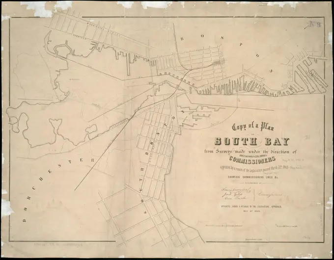
Historical City Maps of Boston

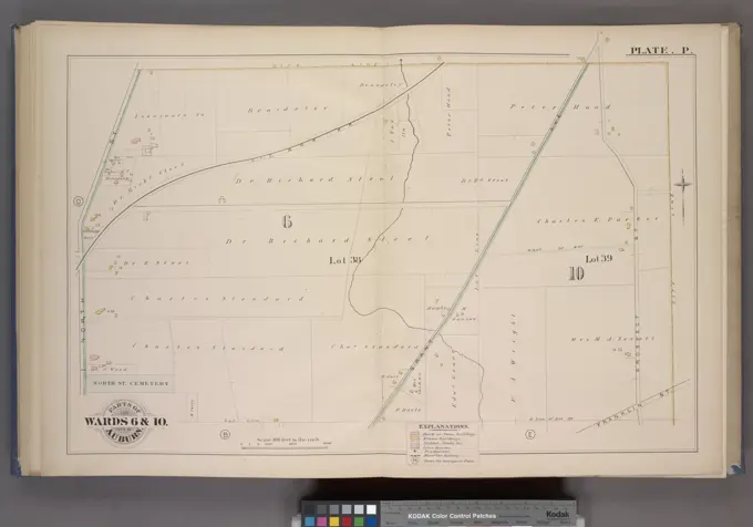
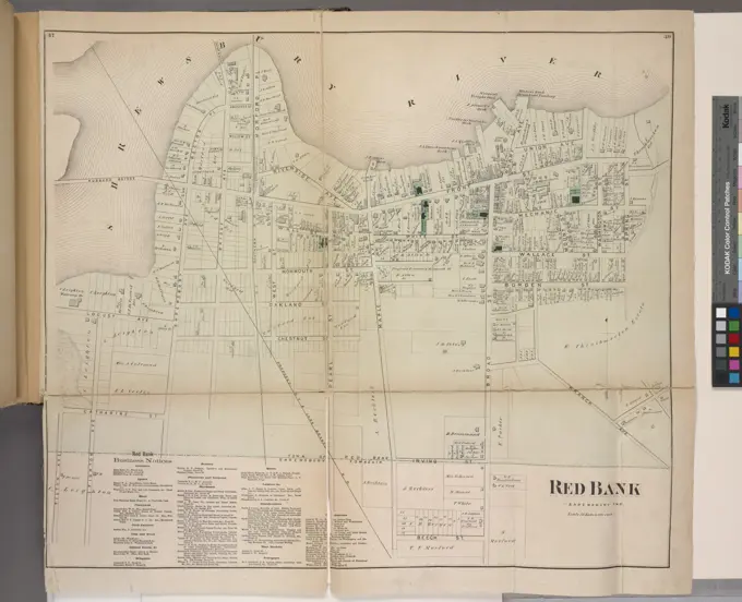
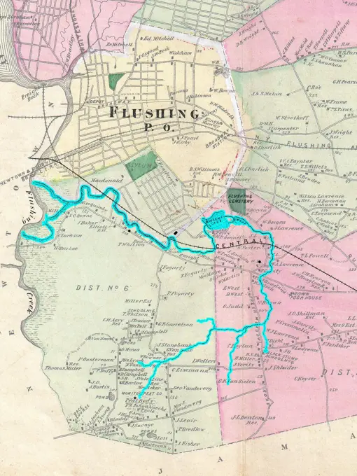
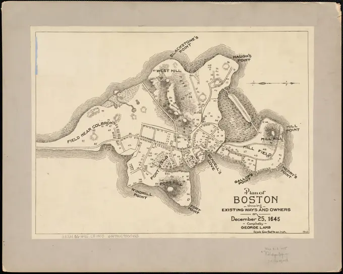
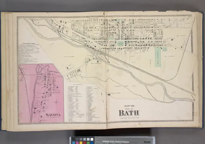
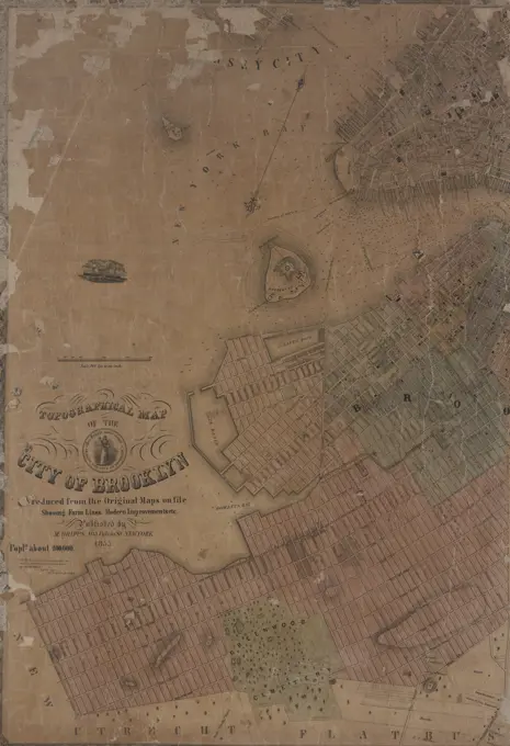
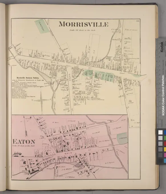
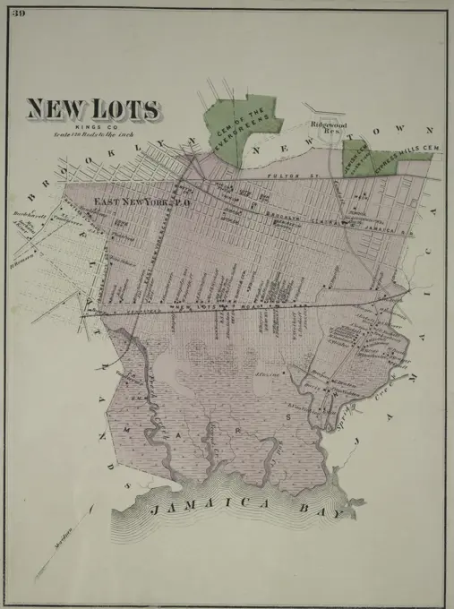
Detailed maps depicting property and land ownership in various neighborhoods of Boston and Newton, showcasing cartographic styles from historical atlases.

Copy of part of plan of inner harbor of Boston, showing commissioners' lines , Boston Harbor Mass., Maps Norman B. Leventhal Map Center Collection
282 assets in this story
4443-75476371
Map of the United States and territories showing the extent of public surveys, Indian and military reservations, land grant railroads, railroads, canals, and other details. Issued in 1879 by the United States General Land Office in Washington, D.C. The map measures 119 x 193 cm and includes color illustrations
6145-48713124
Plan of Salem made by Jonathan P. Saunders, dated 1832 ,. Massachusetts. Office of the Secretary of State
6145-45414559
Banknote on 500 Francs, Central Bank of West African States, West Africa, (c) Burkina Faso, 1982 Banque de France, Paris
6145-50511927
Plan of Westport made by Silvanus Bourne dated 1831 ,. Massachusetts. Office of the Secretary of State
6145-50569885
Atlas of the city of Boston, Boston proper : from actual surveys and official plans. plate 13 , Real property, Massachusetts, Boston, Maps, Landowners, Massachusetts, Boston, Maps, Boston Mass., Maps Norman B. Leventhal Map Center Collection
4443-19590377
A Collection of Surveys of Scottish Estates of the Earl of Selkirk: Whinny Liggate; Balgredan, unknown artist, undated, Graphite, watercolor, gray wash, pen and black and brown ink on slightly textured, moderately thick, cream wove paper, Sheet: 13 × 9 1/2 inches (33 × 24.1 cm), architectural subject
6145-50531887
Birds eye view of the Soudan , Egypt, Aerial views, Sudan, Aerial views Norman B. Leventhal Map Center Collection
6145-59252056
Plan van de Schelde for Antwerp with the location of the forts, during the siege of the Citadel, 1832, 1832 - 1833 print Plan van de Schelde for Antwerp, with the Citadel and the other forts in Dutch hands during the siege of the Citadel by the French. At the bottom right a bet with two images of a battery on the Citadel and a legend of the French siege works. print maker: Netherlandsprinter: Utrecht paper  permanent fortifications Citadel of Antwerp (19th century). Antwerp. Scales
6145-55956838
Freight Terminal Map of New York. 1907. Cartographic. Maps. Lionel Pincus and Princess Firyal Map Division
6145-51390968
Atlas of the city of Chelsea and the towns of Revere & Winthrop, Massachusetts : from actual surveys and official plans. plate 22 , Real property, Massachusetts, Winthrop, Maps, Landowners, Massachusetts, Winthrop, Maps, Winthrop Mass., Maps Norman B. Leventhal Map Center Collection
6145-48445729
Jansen Hermann (1869-1945), development plan of the city expansion, Sprottau in Silesia (03.11.1927): (As Inv.No. 21421): basic plan 1: 2500, consisting of four parts, sheet 4, scale bar. Colored pencils over pressure on cardboard, 65.9 x 128.9 cm (including scan edges) Jansen Hermann  (1869-1945): Bebauungsplan der Stadterweiterung, Sprottau
6145-54522472
Cartographic, Maps. 1901. Lionel Pincus and Princess Firyal Map Division. Bronx (New York, N.Y.), Real property , New York (State) , New York Double Page Plate No. 51, Part of Ward 24, Section 13: Bounded by W. 247th Street, Blackstone Avenue, W. 238th Street and Hudson River
1899-33185
Plan/design/layout of a residential unit near Via Giulia in Rome, where the house of Raphael is located, by Cordini Antonio known as Antonio da Sangallo the Younger, 1520, 16th Century, pen, sanguine. Italy, Tuscany, Florence, Uffizi Gallery, Drawings and Prints Cabinet. Plan lot design: plan: layout of a residential insula: area: district plan.
6145-45877235
Siege of Stralsund, 1715; Plan De La Ville De Stralsund. Map of the Siege of the City of Stralsund by Danish, Prussian and Saxon troops, October 1715. A letter belongs to the map. Part of a collection of signed plans of reinforced places in the Netherlands and surrounding countries at the time of the Spanish Succession War and Great Nordic War (Part B).
6145-46481364
Map of the Heerlijkheid Mechelen; Mechliniae Dirtium. Map of the Heerlijkheid Mechelen. Part of an Atlas with 223 maps of countries and cities and war scaffolding in Europe in the period approx. 1690-1735.
4409-16458
PLANO DEL PUERTO DE ACAPULCO - 1782. Location: SERVICIO HISTORICO MILITAR. MADRID. SPAIN.
6145-50558383
AAF special chart - Gulf of Oman , Bays Bodies of water, Aeronautics. Ralph Finos Map Collection
6145-48713069
Plan of Needham made by Asa Kingsbury, dated 1831 ,. Massachusetts. Office of the Secretary of State
4409-17488107
Dwinae Fluvii nova description (A New Description of the Dvina River). Date/Period: 1680. Print. Handcolored engraving. Height: 550 mm (21.65 in); Width: 610 mm (24.01 in). Author: Jan Janssonius.
6145-55927114
New York (N.Y.). Board of Estimate and Apportionment. Cartographic, Maps. 1916. Lionel Pincus and Princess Firyal Map Division. Zoning , New York (State) , New York, Maps Height District Map Section No. 29
6145-59249132
Main of Mainz by the German armies, 1793, Anonymous, 1793 print Returned map of the siege of Mainz, in French hands, by the combined German armies, April 14 - July 23, 1793. With the positions of the armies. In the caption De Legenda 1-27. Northern Netherlands paper etching siege, position war. maps of cities Mainz
4409-17262290
PLANO DE MARCHA DE ESCUADRA DEL MQ CASA TILLY EN CADIZ. Location: MUSEO NAVAL / MINISTERIO DE MARINA. MADRID. SPAIN.
6145-46755566
Hofors ironwork chronology.ur Carl Sahlin mountain historical collection.
6145-50646197
Map of the city of Rhenen, with the River Rhine and the immediate surroundings.
6145-42604495
Bassel Robert, bridge over the Bodden from Stralsund to Rügen. Schinkel competition 1879 (1879): site plan 1: 2000; Scale bar. Tusche watercolor on the box, 49.6 x 94.4 cm (including scan edges) Bassel Robert : Brücke über den Bodden von Stralsund nach Rügen. Schinkelwettbewerb 1879
6145-50611533
Delaware River: a map of the Delaware river between Philadelphia, PA and Trenton, NJ, 1932.
6145-55913337
Copy of a plan of South Bay.... , Massachusetts  , Boston Harbor Massachusetts  , Suffolk  ,county   , Boston
6145-54549022
Parts of the City Auburn. Wards 6& 10. Cartographic. Atlases, Maps. 1882. Lionel Pincus and Princess Firyal Map Division. Auburn (N.Y.)
6145-43861303
Hydrographic map of Elkhart Lake, Sheboygan Co. Wis. , Hydrology, Wisconsin, Elkhart Lake, Maps, Elkhart Lake Wis., Maps Norman B. Leventhal Map Center Collection
6145-55959024
Map of the town of Morrisania, Westchester Co. N.Y. Cartographic. Maps, Cadastral maps. 1860. Lionel Pincus and Princess Firyal Map Division. Real property , New York (State) , New York, Landowners , New York (State) , New York, Business enterprises , New York (State) , New York , Directories, Morrisania (New York, N.Y.), Morrisania (New York, N.Y.) , Administrative and political divisions
6145-50567179
Copy of a plan of South Bay , Boston Harbor Mass., Maps, Boston Mass., Maps Norman B. Leventhal Map Center Collection
6176-66916448
Plan of the battle of Salem Church or Salem Heights, Virginia Attack and repulse of the 6th Army Corps, Major General John Sedgwick, U.S.A., afternoon of 3rd May 1863. USA Civil War
6145-50529625
Atlas of the city of Boston : Dorchester, Mass. : plate 39 , Boston Mass., Maps, Real property, Massachusetts, Boston, Maps, Landowners, Massachusetts, Boston, Maps, Mattapan Boston, Mass., Maps Norman B. Leventhal Map Center Collection
6145-54550440
General plan of the ruins of Kabah Stephens, John Lloyd, 1805-1852. Cartographic. Illustrations, Prints, Plans, Maps. 1843. Rare Book Division. Yucatán (Mexico : State) , Description and travel, Kabah Site (Mexico)
6145-50566990
Atlas of the city of Boston, wards 25 & 26, Brighton : plate 25 , Boston Mass., Maps, Real property, Massachusetts, Boston, Maps, Landowners, Massachusetts, Boston, Maps, Allston Boston, Mass., Maps Norman B. Leventhal Map Center Collection
6145-54548571
A map of Connecticut. Morse, Jedidiah, 1761-1826. Cartographic. Maps, Atlases. 1794. Lionel Pincus and Princess Firyal Map Division. United States, Geography, United States
6145-58894801
Woodland Cemetery in Dorchester and Roxbury main entrance on Walk-Hill Street : five miles from Boylston market, direct route through Harrison Avenue, Northampton and East Streets passing Grove Hall and through Canterbury Street to Walk Hill Street. Woodland Cemetery in Dorchester and Roxbury main entrance on Walk-Hill Street : five miles from Boylston market, direct route through Harrison Avenue, Northampton and East Streets passing Grove Hall and through Canterbury Street to Walk Hill Street
4443-21773623
Bottom left a scale stick: Scala of 80 rods. Bottom right a legend, Fortress map of Hasselt Hasselt, draughtsman: anonymous, c. 1650 - c. 1799, parchment (animal material), brush, pen, h 479 mm × w 647 mm
6145-50569410
Jamaica Pond master plan , Parks, Massachusetts, Boston, Maps, City planning, Massachusetts, Boston, Maps, Urban renewal, Massachusetts, Boston, Maps, Jamaica Plain Boston, Mass., Maps Norman B. Leventhal Map Center Collection
6145-50569406
The Riverway master plan , Parks, Massachusetts, Boston, Maps, City planning, Massachusetts, Boston, Maps, Urban renewal, Massachusetts, Boston, Maps, Longwood Medical Area Boston, Mass., Maps, Fenway Boston, Mass., Maps Norman B. Leventhal Map Center Collection
6145-59474266
Vestingplattegrond van Libourne, Anonymous, After Christophe Tassin, 1638 print This print is part of an album. publisher: ParisThe Hague paper engraving / etching maps of cities Libourne
6145-55959355
Map of Monroe County, New York Cartographic. Maps. 1852. Lionel Pincus and Princess Firyal Map Division. Landowners , New York (State) , Monroe County, Landowners , New York (State) , Brockport, Monroe County (N.Y.), Brockport (N.Y.), New York (State) , Brockport, New York (State) , Monroe County
6145-55915050
Map of the town of Petersham, Worcester County, Massachusetts : from actual survey by E. M. Woodford. Oriented with north to the upper right. Shows landowners. Includes "List of subscribers," "Plan of Centre," and 14 illustrations of selected buildings.... , Massachusetts  , Worcester  ,county   , Petersham
6145-50571084
Map of a part of the city of Richmond showing the burnt districts , Richmond Va., History, Civil War, 1861-1865, Maps Norman B. Leventhal Map Center Collection
6145-59482201
Map of the Great Trianon with Gardens, 1685 - 1712 print Map of the Palace The Great Trianon with accompanying gardens, located in the gardens of the Palace of Versailles. Print is part of an album. print maker: Northern Netherlandspublisher: AmsterdamThe Hague paper etching French or architectonic garden; formal garden Trianon
6145-50548015
An illustrated map of the River Thames, as compiled from Ordnance Survey, showing the exact course of the Harvard and Oxford Boat Race : Putney to Mortlake, 4 miles, 2 furlongs , Oxford and Cambridge Boat Race, England, Maps, London England, Maps, Thames River England, Maps Norman B. Leventhal Map Center Collection
6145-54549911
Merrick Bay - Channels - Jones' Inlet Cartographic. Atlases, Maps. 1914. Lionel Pincus and Princess Firyal Map Division. Nassau County (N.Y.) , Maps, Real property , New York (State) , Nassau County
6145-51396817
Map of the town of Woodbury, Litchfield County, Connecticut , Real property, Connecticut, Woodbury, Maps, Woodbury Conn. : Town, Maps Norman B. Leventhal Map Center Collection
6145-55176867
Cartographic, Maps. 1873. Lionel Pincus and Princess Firyal Map Division. Long Island (N.Y.) , Description and travel Westville or North West Point, Town of Hempstead. - Little Neck, Town of Flushing, Queens Co. Little Neck, Town of Flushing, Queens Co. North West Point, Town of Hempstead.
6145-50529830
Atlas of the city of Boston, volume seven, Brighton, Mass. : from actual surveys and official plans. plate 15 , Real property, Massachusetts, Boston, Maps, Landowners, Massachusetts, Boston, Maps, Brighton Boston, Mass., Maps Norman B. Leventhal Map Center Collection
6145-55181373
Redbank Business Directory. ; Redbank Village Cartographic. Atlases, Maps. 1873. Lionel Pincus and Princess Firyal Map Division. Monmouth Couty (N.J.) , Description and travel, Real property , New Jersey , Monmouth County
6145-48717543
Mediterranean Sea, west coast of Italy, Avenza Road , Avenza Italy, Maps, Marina di Carrara Italy, Maps, Roadsteads, Italy, Avenza, Maps, Roadsteads, Italy, Marina di Carrara, Maps, Navigation, Italy, Avenza, Navigation, Italy, Marina di Carrara Norman B. Leventhal Map Center Collection
6145-29095567
1873 Beers Map of Flushing and College Point, Queens, New York
6145-59483018
View of Passavas, Willem Swidde (attributed to), 1693 - 1717 print View of a landscape with the former count sizes of the city of Passavas. Title in the end margin. Print is part of an album. print maker: Amsterdampublisher: AmsterdamThe Hague paper etching city-view, and landscape with man-made constructions Passed
6145-48719374
Atlas of Suffolk, county, vol. 7th, late town of Brighton, now ward 19 of Boston, Massachusetts : from actual survey & official records : plate J , Real property, Massachusetts, Boston, Maps, Landowners, Massachusetts, Boston, Maps, Brighton Boston, Mass., Maps Norman B. Leventhal Map Center Collection
6145-51387009
The Riverway master plan , Parks, Massachusetts, Boston, Maps, City planning, Massachusetts, Boston, Maps, Urban renewal, Massachusetts, Boston, Maps, Longwood Medical Area Boston, Mass., Maps, Fenway Boston, Mass., Maps Norman B. Leventhal Map Center Collection
6145-48559311
Plan of Boston showing existing ways and owners on December 25, 1645 , Landowners, Massachusetts, Boston, Maps, Homeowners, Massachusetts, Boston, Maps, Boston Mass., History, Colonial period, ca. 1600-1775, Maps Norman B. Leventhal Map Center Collection
4443-75476673
Map of the town of Concord, Middlesex County Mass., 1852, by Henry Francis Walling. Published by H. F. Walling at No. 81 Washington St., Boston., 1 hand-colored map measuring 60 x 77 cm on a sheet 62 x 80 cm. The map illustrates landowners and real property in Concord, Massachusetts
6145-55914754
Map of the city of Davenport and its suburbs, Scott County, Iowa. Shows lots and landowners. Relief shown by hachures. Decorative border with 15 inset views of buildings and 1 col. view. Some land features illustrated.... , Iowa  , Scott  ,county   , Davenport
6145-51386910
Reading Village, east side Massachusetts : showing streets, buildings, property boundaries and owners, railroad lines, and cemeteries ,. Lucius Beebe Memorial Library Historic Maps
6145-55181171
Savona Business Notices; Savona Village; South Part of Bath Village Cartographic. Atlases, Maps. 1873. Lionel Pincus and Princess Firyal Map Division. Steuben County (N.Y.), Real property , New York (State) , Steuben County, Business enterprises , New York (State) , Steuben County
6145-55181416
Lower section Index Map of Nassau County Long Island Published by E. Belcher Hype. 97 Liberty St. Brooklyn, 5 Beekman St. Manhattan. 1914. Cartographic. Atlases, Maps. 1914. Lionel Pincus and Princess Firyal Map Division. Nassau County (N.Y.) , Maps, Real property , New York (State) , Nassau County
6145-54549085
Au Sable Township; Birminghami Falls Village; Au Sable Subscriber's Business Directory. ; Black Brook Subscriber's Business Directory. ; Au Sable Forks Village Cartographic. Atlases, Maps. 1869. Lionel Pincus and Princess Firyal Map Division. Clinton County (N.Y.)
4443-75469515
Topographical map of the city of Brooklyn, as reduced from the original maps on file, showing farm lines and modern improvements., 1855., New York. Publisher, M. Dripps, Brooklyn (New York, N.Y.)., 1 map on 2 sheets; dimensions 81 x 112 cm
6145-48719690
Plan of farm of George Leonard in Shrewsbury , Shrewsbury Mass., Maps, Real property, Massachusetts, Shrewsbury, Maps, Landowners, Massachusetts, Shrewsbury, Maps Norman B. Leventhal Map Center Collection
6145-55176865
Cartographic, Maps. 1873. Lionel Pincus and Princess Firyal Map Division. Long Island (N.Y.) , Description and travel Far Rockaway, Town of Hempstead.
6145-29095919
Kiawah Island on 1852 U.S. Coast Survey Map of the North and South Edisto Rivers, South Carolina (Charleston)
6145-50516613
Russell's map of Paris and fortifications , Paris France, Maps Norman B. Leventhal Map Center Collection
6145-55181338
North Part of Watkins Village; Watkins Business Notices Cartographic. Atlases, Maps. 1874. Lionel Pincus and Princess Firyal Map Division. Schuyler County (N.Y.), New York (State) , Schuyler County
6145-30213475
Plan of the location of the Soissons Hotel
6145-48718272
Nuova pianta degli scavi di Pompei , Excavations Archaeology, Italy, Pompeii Extinct city, Maps, Pompeii Extinct city, Maps Norman B. Leventhal Map Center Collection
6145-54549506
Morrisville Village; Morrisville Business Notices; Eaton Village Cartographic. Atlases, Maps. 1875. Lionel Pincus and Princess Firyal Map Division. Madison County (N.Y.), Real property , New York (State) , Madison County, Business enterprises , New York (State) , Madison County
6145-50557961
Nuova pianta degli scavi di Pompei , Excavations Archaeology, Italy, Pompeii Extinct city, Maps, Pompeii Extinct city, Maps Norman B. Leventhal Map Center Collection
4443-75459050
A map titled 'New Lots' from Kings County, Long Island, New York, published in 1873 by Beers, Comstock & Cline
6145-55916512
A plan of the reduction of Manila and Cavita. Includes index to points of interest and historical references. "To the right honourable the Earl of Egmont, First Lord Commissioner of the Admiralty, this plate is humbly inscribed, by his most obediant servant, Saml. Cornish." Cataloging, conservation, and digitization made possible in part by The National Endowment for the Humanities: Exploring the human endeavor.... , Philippines  , Cavite  ,province   , Cavite Philippines  , Manila Bay
4443-21773624
Right a scale stick: Scala of 30 rods, Fortress map of Zwartsluis Swarte sluys, draughtsman: anonymous, c. 1650 - c. 1799, parchment (animal material), brush, pen, h 478 mm × w 650 mm
6145-54549572
Islip Village and Vicinity Suffolk County, N.Y. Cartographic. Atlases, Maps. 1888. Lionel Pincus and Princess Firyal Map Division. Atlases , New York (State) , Suffolk County
1889-60421792
A map of ancient Athens, Greece, showing the location of ruins.  From an engraving dated 1832 by J. Hershall after a drawing by William Barnard Clarke.
6145-59074199
Plan of the Jagiellonian Palace in Vilnius in 1794;  1850-1870 (1850-00-00-1870-00-00);
6145-55177010
Cartographic, Maps. 1873. Lionel Pincus and Princess Firyal Map Division. Long Island (N.Y.) , Description and travel Flatbush, Kings Co. L.I. - East Astoria, part of Long Island City, Queens Co. East Astoria, part of Long Island City, Queens Co.
6145-55957117
Revised general plan for Morningside Park, to accompany report by Frederick Law Olmsted and Calvert Vaux.. September 28th, 1887. 1887. Cartographic. Maps. Lionel Pincus and Princess Firyal Map Division
7109-70409669
Interpretive sign, Harpers Ferry National Historic Park, West Virginia, USA. (Editorial Use Only)
PREVIOUS
of 3
NEXT
2401 S. Ervay, Suite 206
Dallas, Texas 75215
United States
Get Started
Free ResearchMy BoardsMy Cart
For Creators
How To License Your ContentContributor PortalFrame of Mind
Resources
API accessPricing
Contact
+1 866 236 0087help@viewpictures.co.uk Contact form
©2026 View Pictures. All Rights Reserved. -A
This site is protected by reCAPTCHA and Google Privacy Policy and Terms of Service apply.