My Boards
View Pictures
  • My Boards

Historical Fire Insurance Maps

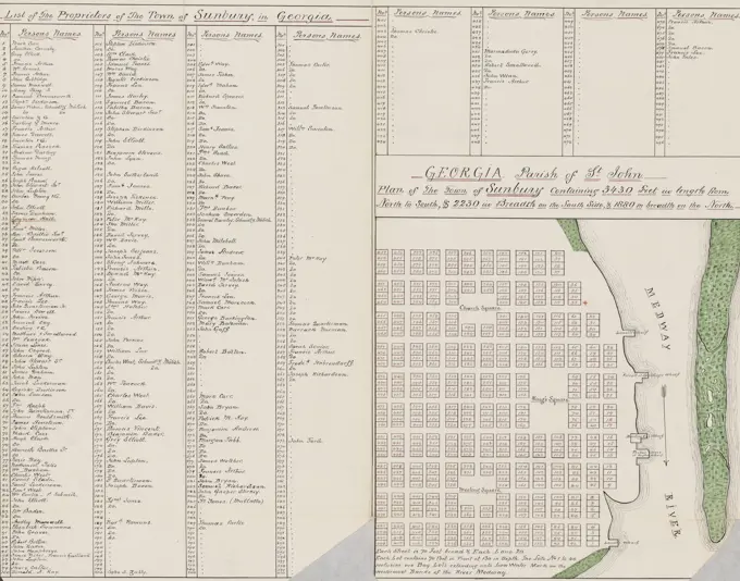
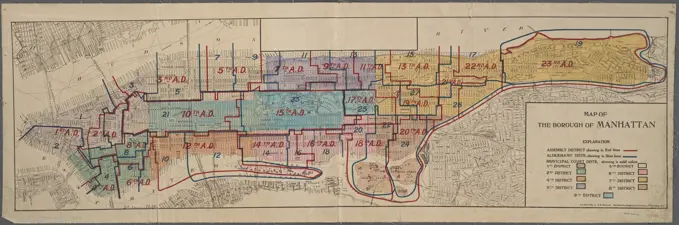
Detailed vintage maps depicting real estate and fire risk in Boston and Manhattan, showcasing intricate layouts and color-coded risk assessments.

Insurance map of Boston : volume 2 : plate 74 , Real property, Massachusetts, Boston, Maps, Fire risk assessment, Massachusetts, Boston, Maps, East Boston Boston, Mass., Maps Norman B. Leventhal Map Center Collection
258 assets in this story
4443-75476584
Manhattan, V. 8, Double Page Plate No. 153 Map bounded by E. 77th St., East River, E. 72nd St., and 1st Ave., 1884-1896. Published by the Sanborn Map Company. Topics include fire insurance, real property, and cities & towns in New York (State)
4409-21520155
Plate 15: Map bounded by Church Street, Canal Street, Elm Street, Pearl Street; Including Franklyn Place, Broadway, Benson Street, Courtlandt Alley, Worth Street, Leonard Street, Franklin Street, White Street, Walker Street, Lispenard St.
6145-54522154
Cartographic, Maps. 1884 - 1936. Lionel Pincus and Princess Firyal Map Division. Fire insurance , New York (State), Real property , New York (State), Cities & towns , New York (State) Queens V. 2, Plate No. 3 Map bounded by Franklin, Halsey, East River
4443-75462287
Map of Jersey City, Version 1, Double Page Plate No. 29, bounded by Prior St., S. 7th St., Colgate St., and Mill Creek. Published in 1866 by I.B. Culver & Co., Jersey City, N.J. This map is associated with fire insurance in New Jersey
6145-50567972
Insurance map of Charlestown : portions of Roxbury (now annexed to Boston) and Cambridge : plate 19 , Fire risk assessment, Massachusetts, Cambridge, Maps, Real property, Massachusetts, Cambridge, Maps, Cambridge Mass., Maps Norman B. Leventhal Map Center Collection
6145-55925762
Cartographic, Maps. 1921 - 1923. Lionel Pincus and Princess Firyal Map Division. Real property , New York (State) , New York, Manhattan (New York, N.Y.) Plate 52: Bounded by (Hudson River Piers) Thirteenth Avenue, W. 32nd Street, Eleventh Avenue and W. 23rd Street
6145-55925145
Cartographic, Maps. 1955 - 1956. Lionel Pincus and Princess Firyal Map Division. Real property , New York (State) , New York (N.Y.), Manhattan (New York, N.Y.) Plate 42, Part of Section 3: Bounded by W. 20th Street, Seventh Avenue, W. 14th Street and Ninth Avenue.
6145-55925242
Cartographic, Maps. 1955 - 1956. Lionel Pincus and Princess Firyal Map Division. Real property , New York (State) , New York (N.Y.), Manhattan (New York, N.Y.) Plate 108, Part of Section 5: Bounded by York Avenue, E. 63rd Street, (East River) Franklin D. Roosevelt Drive and E. 59th Street.
4409-21521712
Plate 7: Map bounded by Murray Street, Broadway, Dey Street, West Street; Including Robinson Street, Park Place, Barclay Street, Vesey Street, Fulton Street, Washington Street, Greenwich Street, College Place, Church Street.
6145-55928550
Cartographic, Maps. 1898. Lionel Pincus and Princess Firyal Map Division. Fire insurance , New York (State), Real property , New York (State), Cities & towns , New York (State) Manhattan, V. 5, Double Page Plate No. 93 Map bounded by West 37th St., 10th Ave., West 32nd St., 12th Ave.
6145-54521899
Cartographic, Maps. 1857 - 1862. Lionel Pincus and Princess Firyal Map Division. Manhattan (New York, N.Y.), Real property , New York (State) , New York Plate 95: Map bounded by West 42nd Street, Eighth Avenue, West 37th Street, Tenth Avenue
6145-54521941
Cartographic, Maps. 1884 - 1936. Lionel Pincus and Princess Firyal Map Division. Fire insurance , New York (State), Real property , New York (State), Cities & towns , New York (State) Queens V. 3, Plate No. 42 Map bounded by Lauren Hill Ave., Montgomery Ave., Clinton Pl., Clifton Ave., Newton Creek
6145-55928758
Cartographic, Maps. 1890. Lionel Pincus and Princess Firyal Map Division. Fire insurance , New York (State), Real property , New York (State), Cities & towns , New York (State) Manhattan, V. 4, Double Page Plate No. 76 Map bounded by E. 42nd St., East River, E. 37th St., 2nd Ave.
4409-21520400
Plate 62: Map bounded by West 9th Street, East 9th Street, University Place, East 4th Street, West 4th Street, Sixth Avenue.
6145-51390507
Atlas of the city of Boston, volume eight, South Boston, Mass. : from actual surveys and official plans. plate 27 , Real property, Massachusetts, Boston, Maps, Landowners, Massachusetts, Boston, Maps, South Boston Boston, Mass., Maps Norman B. Leventhal Map Center Collection
6145-54522186
Cartographic, Maps. 1852. Lionel Pincus and Princess Firyal Map Division. Manhattan (New York, N.Y.), Real property , New York (State) , New York, Fire insurance Plate 19: Map bounded by Rivington Street, East Street, Grand Street, Columbia Street
6145-55925970
Cartographic, Maps. 1927. Lionel Pincus and Princess Firyal Map Division. Real property , New York (State) , New York, Manhattan (New York, N.Y.) Plate 108, Part of Section 5: Bounded by York Avenue, E. 64th Street, Exterior Street, East River and E. 59th Street
6145-55926046
Cartographic, Maps. 1942. Lionel Pincus and Princess Firyal Map Division. Real property , New York (State) , New York (N.Y.), Bronx (New York, N.Y.) , Maps Double Page Plate No. 2, Part of Sections 9 & 10, Borough of the Bronx: Bounded by E. 135th Street, Triborough Bridge, Cypress Avenue, (Bronx Kills) E. 132nd Street and Willis Avenue
4409-21520223
Plate 12: Map bounded by Rutgers Street, South Street, Market Street, Division Street; Including Pelham St, Pike Street, Pike Slip, Birmingham Street Mechanic's Street, East Broadway, Henry Street, Madison Street, Monroe Street, Cherry Stree.
6145-54570133
The Belnord Apartments. Floor plan - 2nd, 5th, 7th and 10th floors.. Photographs, Floor plans. 1910-03. Irma and Paul Milstein Division of United States History, Local History and Genealogy. Apartment houses , New York (State) , New York, Dwellings , New York (State) , New York
6145-55925677
Cartographic, Maps. 1921 - 1923. Lionel Pincus and Princess Firyal Map Division. Real property , New York (State) , New York, Manhattan (New York, N.Y.) Plate 108: Bounded by Avenue A, E. 67th Street, Exterior Street, East River and E. 59th Street
6145-54522102
Cartographic, Maps. 1884 - 1936. Lionel Pincus and Princess Firyal Map Division. Fire insurance , New York (State), Real property , New York (State), Cities & towns , New York (State) Queens V. 2, Plate No. 46 Map bounded by Potter Ave., 18th Ave., Wilson Ave., 14th Ave.
6145-48453974
Punitzer Martin (1889-1949), propiedad de Sr. Carlos 2 Bartsch, Valdivia (1940): Plan content N.N. detected. Material/technology N.N. Captured, 49 x 58.4 cm (including scan edges) Punitzer Martin  (1889-1949): Propiedad de Sr. Carlos 2 Bartsch, Valdivia
6145-54570201
Typical floor plan of The Kenilworth.. Photographs, Floor plans. 1910-03. Irma and Paul Milstein Division of United States History, Local History and Genealogy. Apartment houses , New York (State) , New York, Dwellings , New York (State) , New York
6145-55175431
Cartographic, Maps. 1852. Lionel Pincus and Princess Firyal Map Division. Manhattan (New York, N.Y.), Real property , New York (State) , New York, Fire insurance Plate 1: Map bounded by Bowling Green Row, Marketfield Street, Beaver Street, William Street, Old Slip, South Street, Whitehall Street, State Street
6145-55175960
E.B. Hyde & Co.. Cartographic, Maps. 1907. Lionel Pincus and Princess Firyal Map Division. Brooklyn (New York, N.Y.) , Maps, Real property , New York (State) , New York Brooklyn, Vol. 7, Double Page Plate No. 7; Part of Ward 31, Section 20; Map bounded by E. 9th St., Avenue O, Gravesend Ave.; Including Avenue L, Ocean Parkway, Avenue M
6145-55927181
Cartographic, Maps. 1855. Lionel Pincus and Princess Firyal Map Division. Manhattan (New York, N.Y.), Real property , New York (State) , New York 1st & 2nd Wards. Plate G: Map bounded by Platt Street, Burling Slip, South Street, Wall Street, William Street; Including Maiden Lane, Fletcher Street, Liberty Street, Cedar Street, Depeyster Street, Pine Street, Gold Street, Pearl Street, Water Street, Front Street
4443-75471583
Georgia, parish of St. John plan of the town of Sunbury, containing 3430 feet in length from north to south, 2230 feet in breadth on the south side, and 1880 feet in breadth on the north. Additional, Georgia, parish of Saint John. Additional, Plan of the town of Sunbury., 1876., Georgia. Publisher, C. C. Jones, Jr., 1 map manuscript, color; 27 x 28 cm, on sheet 44 x 55 cm. Pen, ink, and watercolor on paper
4443-75471338
Plate 92 Map bounded by West 32nd Street, Tenth Avenue, West 27th Street, Eleventh Avenue., 1854., New York, NY. Publisher, William Perris. Focus Real property, New York (State), Fire insurance
6145-55175593
Cartographic, Maps. 1914. Lionel Pincus and Princess Firyal Map Division. Manhattan (New York, N.Y.), Real property , New York (State) , New York Plate 30, Part of Section 7: Bounded by W. 145th Street, Lenox Avenue, W. 139th Street and Eighth Avenue
6145-54548857
Map of the proposed widening of Rector & Morris streets Cartographic. Maps. 1849. Lionel Pincus and Princess Firyal Map Division. New York (N.Y.), Landowners , New York (State) , New York, Real property , New York (State) , New York, Wall Street (New York, N.Y.) , Maps, New York (N.Y.) , Maps
6145-30279190
Project for a boys and girls school in Klosterneuburg, floor plan of the low party, Otto Wagner -, architect
6145-50521309
Street plan, Hale St. , Streets. Lawrence
6145-55926857
Cartographic, Maps. 1914. Lionel Pincus and Princess Firyal Map Division. Manhattan (New York, N.Y.), Real property , New York (State) , New York Plate 28, Part of Section 7: Bounded by W. 145th Street, Amsterdam Avenue, W. 139th Street, and (Hudson River) Riverside Drive
6145-54570208
Floor plans of St. John Court.. Photographs, Floor plans. 1910-03. Irma and Paul Milstein Division of United States History, Local History and Genealogy. Apartment houses , New York (State) , New York, Dwellings , New York (State) , New York
6145-48478737
Klomp Johannes Franziskus (1865-1946), 3 single-family houses, Hanover-Waldhausen (06.05.1902): attic and basement floor plan 1: 100. Ink, ink colored, watercolor on transparent, 49.2 x 54.7 cm (including scan edges) Klomp Johannes Franziskus  (1865-1946): 3 Einfamilienhäuser, Hannover-Waldhausen
4409-21521545
Double Page Plate No. 10: Bounded by Sixth Ave., Thirty Ninth St.,Ninth Ave., Forty Ninth St., Eighth Ave. and Sixtieth St.
4443-75478439
Seven images on one page related to the Altes Reich, Dynastie VI, showcasing Schech Said Sheikh Sa'id. The images include details of Grab 4 and Grab 6, as well as Kauamât and the Chenoboskion Qa.sr wa-al-.Sayyâd Site. Created between 1849 and 1856 by Ernst Weidenbach and published by Nicolaische Buchhandlung in Berlin. The content includes themes of Egyptian antiquities, hieroglyphics, and architectural elements such as doors and doorways
6145-50565872
Peking , Beijing China, Maps Norman B. Leventhal Map Center Collection
4409-21509200
Part of Sections 7 & 8: Plate 160.
6145-54570197
Floor plans of The Kenmare.. Photographs, Floor plans. 1910-03. Irma and Paul Milstein Division of United States History, Local History and Genealogy. Apartment houses , New York (State) , New York, Dwellings , New York (State) , New York
6145-55957167
Map of the Borough of Manhattan, showing the Assembly, Aldermanic, and Municipal Court Districts 1918. Cartographic. Maps. Lionel Pincus and Princess Firyal Map Division
6145-50636192
Plan of the temple in the Totomi province unknown
6145-54570193
Floor plans of The Stratford.. Photographs, Floor plans. 1910-03. Irma and Paul Milstein Division of United States History, Local History and Genealogy. Apartment houses , New York (State) , New York, Dwellings , New York (State) , New York
6145-55183249
The Maranamay, 611 West 112th Street ; Plan of first floor; Plan of upper floors.. text. Floor plans, Photographs, pages (components). 1909. Irma and Paul Milstein Division of United States History, Local History and Genealogy. Architecture , Apartment houses , New York Metropolitan Area
6145-55181274
Johnsons Creek Village; Hartland Village; Pekin Village; North Ridge Village; Hartland Business Notices Cartographic. Atlases, Maps. 1875. Lionel Pincus and Princess Firyal Map Division. Niagara County (N.Y.), Orleans County (N.Y.), Real property , New York (State) , Niagara County, Real property , New York (State) , Orleans County
6145-48719178
Plan général du palais et du parc de l'Exposition universelle de 1867 , Paris France, Maps Norman B. Leventhal Map Center Collection
6145-54523878
Cartographic, Maps. 1857 - 1862. Lionel Pincus and Princess Firyal Map Division. Manhattan (New York, N.Y.), Real property , New York (State) , New York Volume 7 Index Map
6145-54570212
Audubon Park Apartments. Southeast Corner Broadway and 156th Street.. Photographs, Floor plans. 1910-03. Irma and Paul Milstein Division of United States History, Local History and Genealogy. Apartment houses , New York (State) , New York, Dwellings , New York (State) , New York
6145-50530006
Atlas of the county of Suffolk, Massachusetts : vol. 4th including East Boston, city of Chelsea, Revere and Winthrop : from actual survey official records & private plans : plate J , Real property, Massachusetts, Boston, Maps, Landowners, Massachusetts, Boston, Maps, East Boston Boston, Mass., Maps Norman B. Leventhal Map Center Collection
6145-55961153
The Ponchetrain. Nos. 312-14-16 West 109 Street.. Photographs, Floor plans. 1910-03. Irma and Paul Milstein Division of United States History, Local History and Genealogy. Apartment houses , New York (State) , New York, Dwellings , New York (State) , New York
6145-55925066
Cartographic, Maps. 1925. Lionel Pincus and Princess Firyal Map Division. Real property , New York (State) , New York, Manhattan (New York, N.Y.) Street Index: Abington Square - Harry Howard Square
6145-55183368
Barnard Court, no. 15 Claremont Avenue.. Photographs, Floor plans. 1910-03. Irma and Paul Milstein Division of United States History, Local History and Genealogy. Apartment houses , New York (State) , New York, Dwellings , New York (State) , New York
6145-54570215
The Pasadena, Broadway at Sixty-first Street.. Photographs, Floor plans. 1910-03. Irma and Paul Milstein Division of United States History, Local History and Genealogy. Apartment houses , New York (State) , New York, Dwellings , New York (State) , New York
6145-55183390
The Melba, Central Park West at North corner of 102nd Street.. Photographs, Floor plans. 1910-03. Irma and Paul Milstein Division of United States History, Local History and Genealogy. Apartment houses , New York (State) , New York, Dwellings , New York (State) , New York
6145-55183287
No. 1 Lexington Avenue. Gramercy Park.. Photographs, Floor plans. 1910-03. Irma and Paul Milstein Division of United States History, Local History and Genealogy. Apartment houses , New York (State) , New York, Dwellings , New York (State) , New York
6145-55183381
Lasanno Court, 307-313 West Seventy-ninth Street.. Photographs, Floor plans. 1910-03. Irma and Paul Milstein Division of United States History, Local History and Genealogy. Apartment houses , New York (State) , New York, Dwellings , New York (State) , New York
6145-55183371
The Devonshire, Southeast corner Broadway and 112th Street.. Photographs, Floor plans. 1910-03. Irma and Paul Milstein Division of United States History, Local History and Genealogy. Apartment houses , New York (State) , New York, Dwellings , New York (State) , New York
PREVIOUS
of 3
NEXT
2401 S. Ervay, Suite 206
Dallas, Texas 75215
United States
Get Started
Free ResearchMy BoardsMy Cart
For Creators
How To License Your ContentContributor PortalFrame of Mind
Resources
API accessPricing
Contact
+1 866 236 0087help@viewpictures.co.uk Contact form
©2026 View Pictures. All Rights Reserved. -B
This site is protected by reCAPTCHA and Google Privacy Policy and Terms of Service apply.