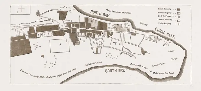
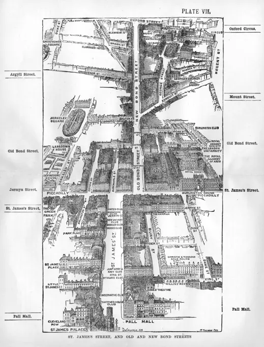
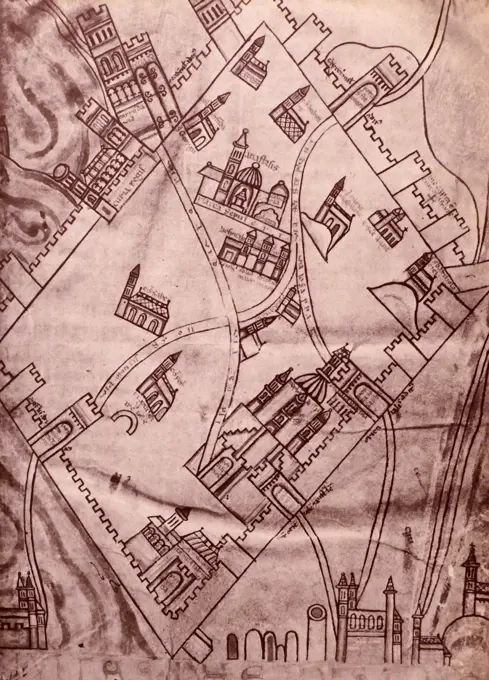
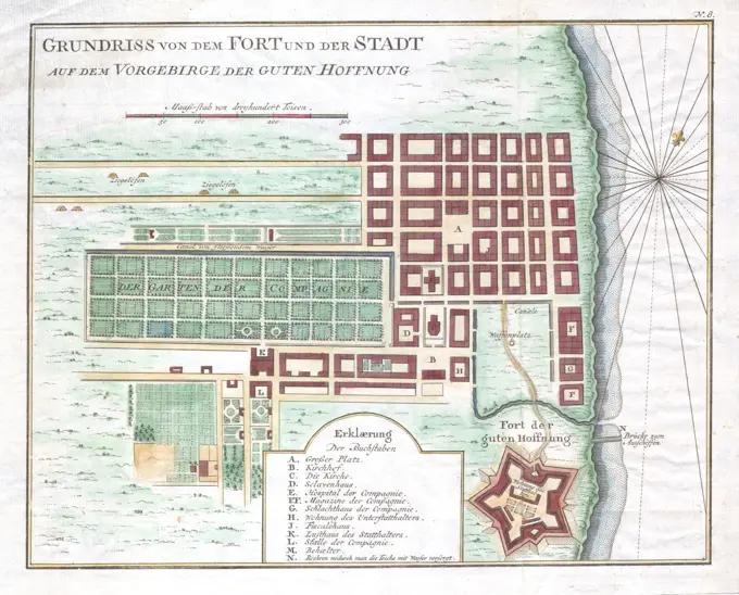
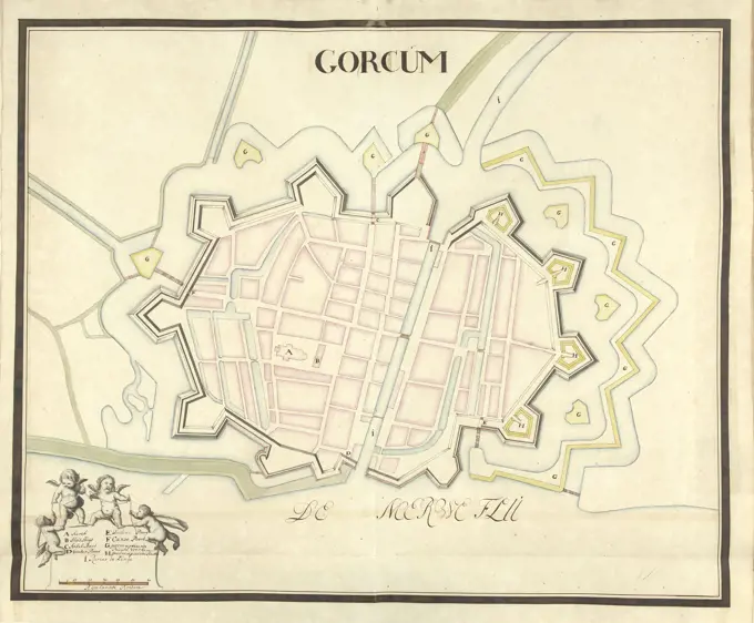
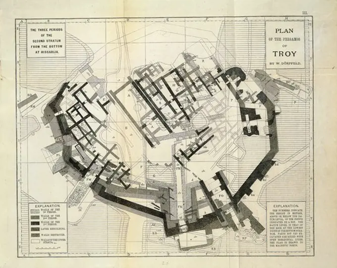
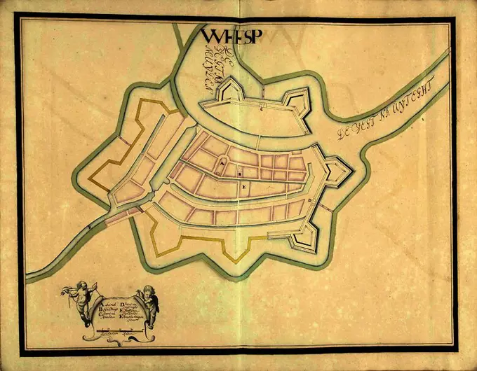
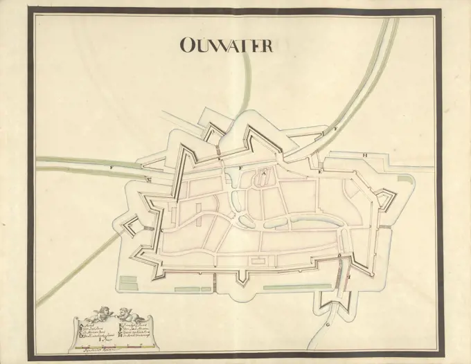
My Boards
View Pictures
  • My Boards

Historical Maps

A variety of detailed historical maps depicting urban layouts, development plans, and geographical features across different cities, including cartographic insights from various eras.

Property map, South Cove urban renewal area R-92 , Real property, Massachusetts, Boston, Maps, Bay Village Boston, Mass., Maps, City planning, Massachusetts, Boston, Maps
259 assets in this story
6145-50447162
test111
6145-48981949
UTRECHT.
6145-44061694
Overview sketch of the Alertstadt
6145-52817210
Feather drawing by Joseph Daniel von Huber depicting the Vienna bird show with birds, spectators, and architectural elements, 1769-1773.
6145-50443891
Jansen Hermann (1869-1945), development plan of the city expansion, Templin. Overview plan: (Inv.No.N 21246-21249 on a sheet): basic and location plan 1: 2500, scale bar (2nd half See Inv.No. 21245.2). Colored pencils and chalk over pressure on cardboard, 131.00 x 100.00 cm (including scan edge). Architecture Museum of the Technical University of Berlin Inv. No. 21245.1. Jansen Hermann  (1869-1945): Bebauungsplan der Stadterweiterung, Templin. Übersichtsplan
4409-4412
PLANO DE MADRID DETALLE PLAZA DE PALACIO REAL- 1656. Author: PEDRO TEIXEIRA (1592-1662) PEDRO TEXEIRA. Location: ARCHIVO HISTORICO DE LA VILLA. MADRID. SPAIN.
6145-42606963
Kassbaum Gustav (1878-1929), village church in Neindorf. Monthly competition October 1909 (10.1909): Department of the village; Explanation text. Pencil on paper, 13.9 x 12.6 cm (including scan edges) Kassbaum Gustav  (1878-1929): Dorfkirche, Neindorf. Monatskonkurrenz Oktober 1909
6145-30272795
Plan from Vienna , with , his Barricaden , on May , Unknown
6145-48446662
Jansen Hermann (1869-1945), development plan of the Troisdorf city expansion (1918-1918): Overview and basic plan 1: 2500. Ink on transparent, 43 x 62.2 cm (including scan edges) Jansen Hermann  (1869-1945): Bebauungsplan der Stadterweiterung Troisdorf
6145-29928504
Map of a district of Ménilmontant in the 18th century.
6145-50444749
N.N., cemetery systems and chapels (without date): Plan content N.N. detected. Material/technology N.N. recorded, 77.6 x 111.6 cm (including scan edges) N.N. : Friedhof Ohlsdorf, Hamburg
6145-59427788
Map of the Watergraafsmeer (part at the top right), Pieter van den Berge, 1719 print Share (top right) of a map of the Watergraafsmeer. Amsterdam paper engraving / etching maps of separate countries or regions. polder, reclaimed land. coat of arms (as symbol of the state, etc.). armorial bearing, heraldry Watergraafsmeer
4443-21170940
THE FRENCH IN MADAGASCAR, PLAN OF TAMATAVE, SHOWING THE AMOUNT OF PROPERTY OWNED BY DIFFERENT NATIONS, 1883: 1. Site of the Hova Garrison Town. 2. Principal Hova Fort. 3. Mr. Shaw's Compound. 4. Native Huts (Burnt). 5. Foreigners' Cemetery. 6. Cattle Market. 7. Mission. 8. Indian Shops. 9. British Consulate. 10. Site of Native Town (Burnt). 11. French Catholic Mission. 12. British Consul's House and Compound. 13. German Consulate. 14. French Consulate. 15. Customs. 16. Huts of Native Town.
6145-30274125
, Karlsplatz - flying, postcard, Verlag Luftbild Ges, Photographer, publisher of the state associations in Vienna and Lower Austria of the Central Association of War Invalider and Bidelines, Producer
1746-21102047
Babylonian Map of the World on Clay. Showing the ocean surrounding the world and the position of Babylon on the Euphrates.
6145-53197008
City map of Jönköping in 1906.
6145-54288735
Top--Berlin, Germany-Just to cause a few more Berliners to flow their tops (and their houses too) from 20 Feb through 19 March 1945, RAF Mosquitoes smacked the capital accurately every night with approximately 80 tons of bombs.
6145-52359041
St. Jean D'Acre Barrault, Emile, 1799-1869. Cartographic. Maps. 1837. General Research Division. Egypt , History , Mohammed Ali, 1805-1849
6176-65988185
Vintage Street Map of Central Cambridge, England, in the 19th century; Black and White Illustration;
6145-52359142
Dakar en 1888 Faidherbe, Louis Léon César, 1818-1889. Cartographic. Illustrations. 1889. Schomburg Center for Research in Black Culture, Jean Blackwell Hutson Research and Reference Division. Senegal, Dakar (Senegal : Region)
6145-59483212
Map of Tournai, Anonymous, 1652 - 1662 print Map of Tournai. At the top right a numerical legend, including the city coat of arms. Title in double frame at the bottom right. Amsterdam paper engraving maps of cities Torlative
6145-58953244
Description: A Bird's-Eye View of the Procession Wending its Way Through the City Location: Sydney, New South Wales, Australia Date: 23 March 1932 australia, australasia, oceania, australasiathroughalens
6145-42610021
Böhmer Franz (1907-1943), Schlageter-Forum, Düsseldorf: site plan 1: 2000. Pencil, coal on transparent, 96.5 x 177.5 cm (including scan edge).
6145-48441991
Knoblauch Eduard (1801-1865), site plan from Gdansk. () (Without Dat.): Department of the city of Gdansk (). Pencil watercolor, 54.1 x 81.6 cm (including scan edges) Knoblauch Eduard  (1801-1865): Lageplan von Danzig.
6145-48448572
Jansen Hermann (1869-1945), traffic and settlement planning of the expansion of the cities of Neukirchen and Vluyn (01.08.1927): Development plan: basic plan and map 1: 2500, scale bar. Ink on transparent, 94.3 x 199.8 cm (including scan edges) Jansen Hermann  (1869-1945): Verkehrs- und Siedlungsplanung der Erweiterung der Städte Neukirchen und Vluyn
6145-48448005
Jansen Hermann (1869-1945), development plan in Berlin-Gatow and Berlin-Kladow (November 13, 1942): Department Kladow 1: 1000. Pencil and ink on transparent, 68.4 x 90 cm (including scan edges) Jansen Hermann  (1869-1945): Bebauungsplan Berlin-Gatow und Berlin-Kladow
4220-21928523
A map of the St. James's and Bond Street areas of London, with a number of key landmarks annotated including the famous gentlemen's clubs of St. James's Street (White's, Devonshire, Boodles and Brooks), St. James's Palace, Berkeley Square, Hanover Square, Burlington Arcade, the Royal Academy at Burlington House and Claridge's Hotel.       Date: 1918
1848-19254902
Stadtplan, 1892, La Spezia, Italien, digital restaurierte Reproduktion einer Originalvorlage aus dem 19. Jahrhundert
1746-29010769
A plan of Jerusalem dating back to the Crusaders. Dated 11th Century
6145-29095970
1750 Bellin Map of Cape Town, South Africa
1788-17605
Map of the central Campus Martius, drawing
6145-48435356
Unknown architect, agricultural experiment, Bromberg (04.1906): site plan 1: 1000. Lithograph colored, 55.9 x 78.8 cm (including scan edges)
4443-21725745
Map of Gorinchem, ca. 1701-1715, Samuel Du Ry de Champdoré, 1701 - 1715, Map of the fortifications around the city of Gorinchem, ca. 1701-1715. Bottom left a cartouche with the legend A-I in Dutch, decorated with four putti. Part of a collection of drawn plans of fortified towns in the Netherlands and surrounding countries at the time of the War of the Spanish Succession (part A)., draughtsman: Samuel Du Ry de Champdoré, Netherlands, 1701 - 1715, paper, h 530 mm × w 630 mm
4069-325
Plan of Pergamos of Troy by W.Dorpfeld showing 3 periods of 2nd stratum, engraving from Schliemann's Excavations, An Archaeological and Historical Study, 1891, by Karl Schuchhardt
6145-48447965
Jansen Hermann (1869-1945), partial development plan of the Goslar city expansion. At Köppelsbleek (January 20, 1926): Variant 1: Department 1: 1000. Ink and pencil on transparent, 28.6 x 47.3 cm (including scan edges) Jansen Hermann  (1869-1945): Teilbebauungsplan der Stadterweiterung Goslar. Am Köppelsbleek
6145-48447745
Jansen Hermann (1869-1945), total development plan Ankara. Partial development plan Hochschulviertel (10.01.1933): Grund and site plan sports facility north ismet pasa 1: 4000. Ink on transparent, 27.9 x 22.5 cm (including scan edges) Jansen Hermann  (1869-1945): Gesamtbebauungsplan Ankara. Teilbebauungsplan Hochschulviertel
6145-48447986
Jansen Hermann (1869-1945), Dortmund development plan (23.05.1938): Bahnhofsviertel, site plan, street profiles, cut and floor plan details 1: 1000 (from Inv.No. 22157). Colored pencil over a break on paper, 66.4 x 84.6 cm (including scan edges) Jansen Hermann  (1869-1945): Bebauungsplan Dortmund
6145-45749500
Map of Amsterdam with design and implementation of the fourth explanation (third part); Flat-base from the old and new Royinge der Stede Amsterdam Aenworden with all its public buildings waer from the old Roying in 't Bruyn and the new in' t Bleeck wort uytgeprot; The new begins that the old shore with stained Linien is signed / Veteris Novaeque Urbis Amstelodamensis Ichnographia (...). Third part of a map of Amsterdam with design and implementation of the fourth explanation, consisting of six parts. Numbered at the bottom right: 3.
6145-50444253
Jansen Hermann (1869-1945), planning for Plowdiw (01.03.1944): sports grounds, site plan 1: 1000. Bleisite and ink on transparent, 81.8 x 72.3 cm (including scan edges) Jansen Hermann  (1869-1945): Planung für Plowdiw
4443-21725757
Plattegrond van Woerden, ca. 1701-1715, Samuel Du Ry de Champdoré, 1701 - 1715, Plan of the fortifications around the town of Woerden, ca. 1701-1715. Bottom left a cartouche with the legend A-F in Dutch, with four putti. Part of a collection of drawn plans of fortified towns in the Netherlands and surrounding countries at the time of the War of the Spanish Succession (part A)., draughtsman: Samuel Du Ry de Champdoré, Netherlands, 1701 - 1715, paper, h 482 mm × w 612 mm
6145-48446728
Jansen Hermann (1869-1945), construction of a settlement for the non-profit small house construction company in Berlin-Heiligensee (01.08.1922): Grund- and site plan 1: 1000. Ink and pencil on transparent, 59.8 x 75.3 cm (including scan edges) Jansen Hermann  (1869-1945): Bau einer Siedlung für die gemeinnützige Kleinhausbaugesellschaft, Berlin-Heiligensee
6145-50567306
Map of the city of Cambridge , Cambridge Mass., Maps Norman B. Leventhal Map Center Collection
4409-61878984
MAP OF BARCELONA, LA RIBERA DISTRICT. 1716. 18TH CENTURY, ENGRAVING. Museum: Museo de Historia, Barcelona.
6145-50571951
Plan de la ville de Meaco , Cities & towns. Ralph Finos Map Collection
1848-61897389
Historical illustration from the 19th Century, map of Muenster in the 16th Century at the time of the Anabaptists, Muenster, Germany, Europe
6145-29248289
Plan of the Royal Botanic Society's Gardens, Regents Park. Drawing after E.M. Sowerby, 1886.
4409-17518052
Plattegrond van Weesp, ca. 1701-1715. Weesp (title on object). Draughtsman: Samuel Du Ry de Champdoré. Dating: 1701 - 1715. Place: Netherlands. Measurements: h 482 mm × w 620 mm. Museum: Rijksmuseum, Amsterdam.
6145-48446828
Jansen Hermann (1869-1945), partial development plan, Bergen (October 23, 1916): Department 1: 1000, Phase 1st ink, pencil on transparent, 71.1 x 94.4 cm (including scan edges) Jansen Hermann  (1869-1945): Teilbebauungsplan, Bergen
6145-50444367
Jansen Hermann (1869-1945), development plan of the city expansion, Greifenberg: basic plan and site plan 1: 2500, composed of two parts, scale bar. Colored pencil on pressure on paper, 109.10 x 150.00 cm (including scan edge). Architecture Museum of the Technical University of Berlin Inv. No. 21463. Jansen Hermann  (1869-1945): Bebauungsplan der Stadterweiterung, Greifenberg
4443-21725758
Map of Oudewater, ca. 1701-1715, Samuel Du Ry de Champdoré, 1701 - 1715, Map of the fortifications around the town of Oudewater, ca. 1701-1715. Bottom left a cartouche with the legend A-I in Dutch, with two putti. Part of a collection of drawn plans of fortified towns in the Netherlands and surrounding countries at the time of the War of the Spanish Succession (part A)., draughtsman: Samuel Du Ry de Champdoré, Netherlands, 1701 - 1715, paper, h 482 mm × w 620 mm
4409-17518107
Plattegrond van Klundert, ca. 1701-1715. Clunder (title on object). Draughtsman: Samuel Du Ry de Champdoré. Dating: 1701 - 1715. Place: Netherlands. Measurements: h 482 mm × w 620 mm. Museum: Rijksmuseum, Amsterdam.
6145-48455177
N.N., cemetery systems and chapels (without date): Plan content N.N. detected. Material/technology N.N. Captured, 57.4 x 92.4 cm (including scan edges) N.N. : Hauptfriedhof, Stettin
6145-50443857
Unknown author, settlement for war injuries, Neisse (September 15, 1917): Map of the city of Neisse from 1905 as a planning document 1: 2000. Pencil over pressure on paper, 109.6 x 110.4 cm (including scan edges) unbek. Verfasser : Siedlung für Kriegsverletzte, Neiße
6145-50444300
Jansen Hermann (1869-1945), total development plan Ankara. Partial development plan inner city (03.07.1933): site plan 1: 500, road profile 1: 100, southern section after Istasasyon Saman Tazari Caddesi. Ink on transparent, 80.1 x 94.6 cm (including scan edges) Jansen Hermann  (1869-1945): Gesamtbebauungsplan Ankara. Teilbebauungsplan innere Stadt
6145-48487512
N.N., Bankalized Fulda from Kassel to Hannoversch Münden: Power map of the Fulda from km 26.1 to 27.4: Department 1: 2000. Lithograph colored on paper, 63 x 99.9 cm (including scan edges) N.N. : Kanalisierte Fulda von Kassel bis Hann. Münden
4449-77726852
Old city maps of Isny, cast into the Gewweg, Isny im Allgäu, Baden-Württemberg, Germany
6145-50444207
Jansen Hermann (1869-1945), redesign of the Horst-Wessel-Platz in Neustrelitz (January 28, 1937): Department 1: 500, Suggestion 4th ink, coal on transparent, 44.9 x 50.1 cm (including scan edges)  Jansen Hermann  (1869-1945): Umgestaltung des Horst-Wessel-Platzes, Neustrelitz
1848-49519705
75.000, ground plan, harbour basin, dry dock, district, railway line, cartography, historical illustration 1896, Marseille, port, Gulf of Lion, Mediterranean Sea, France, Europe
6145-50444420
Jansen Hermann (1869-1945), total development plan in Gaziantep. Residential area in the north-west (November 25, 1938): Submitter 2b, scale bar. Tusche over a break on transparent, 69.2 x 92.7 cm (including scan edges) Jansen Hermann  (1869-1945): Gesamtbebauungsplan, Gaziantep. Wohngebiet im Nord-Westen
PREVIOUS
of 3
NEXT
2401 S. Ervay, Suite 206
Dallas, Texas 75215
United States
Get Started
Free ResearchMy BoardsMy Cart
For Creators
How To License Your ContentContributor PortalFrame of Mind
Resources
API accessPricing
Contact
+1 866 236 0087help@viewpictures.co.uk Contact form
©2026 View Pictures. All Rights Reserved. -A
This site is protected by reCAPTCHA and Google Privacy Policy and Terms of Service apply.