My Boards
View Pictures
  • My Boards
← Documents & Records

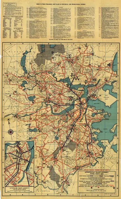
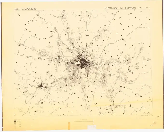
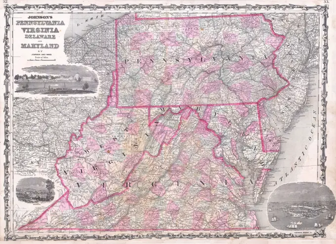
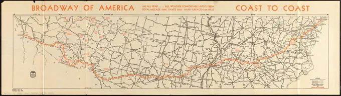
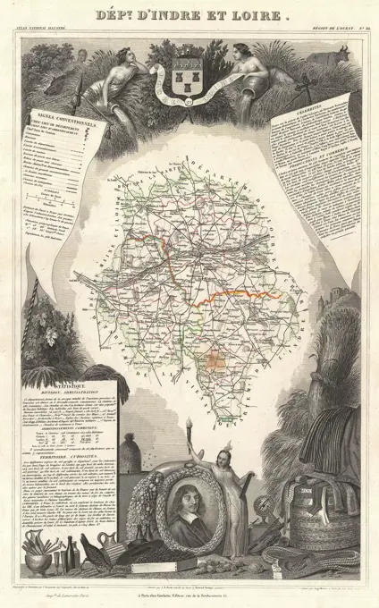
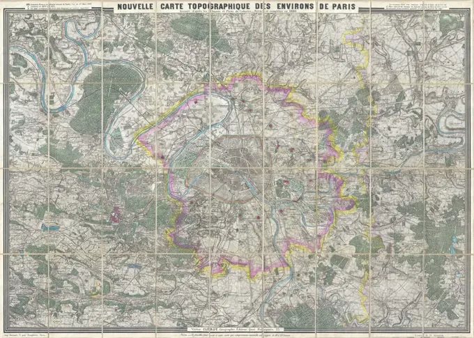
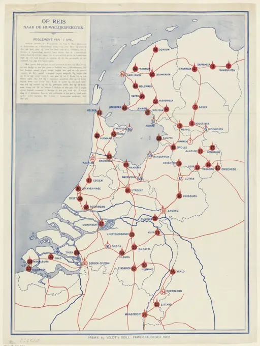
Historical Maps and Cartography

Maps illustrating various regions and urban areas, showcasing geographic and political developments in the 19th and 20th centuries.

Map of Boston and vicinity. Title supplied by cataloger. Oriented with north toward the upper left... Part of the metropolitan district. Part of the metropolitan district, Massachusetts  , Suffolk  ,county   , Boston
Map of Boston and vicinity. Title supplied by cataloger. Oriented with north toward the upper left... Part of the metropolitan district. Part of the metropolitan district, Massachusetts , Suffolk ,county , Boston
252 assets in this story
6145-50446617
N.N., Plans of Berlin and the surrounding area: Spandau, Grunewald (without date): floor plan 1: 25000. Print colored on paper, 63.4 x 48.8 cm (including scan edges) N.N. : Pläne von Berlin und Umgebung: Spandau, Grunewald
6145-48447171
Jansen Hermann (1869-1945), regulation of the old town in Stockholm (29.07.1933): Creation of inner-city traffic roads, proposal A: Overview plan 1: 20000. Light break on the cardboard, 47.7 x 43.3 cm (including scan edges) Jansen Hermann  (1869-1945): Regulierung der Altstadt, Stockholm
6145-51391710
The Builder map of the county of London : shewing the boundaries of the surveyors' districts under the building acts , Zoning, England, London, Maps, London England, Maps Norman B. Leventhal Map Center Collection
6145-51395503
Metropolitan Transit Authority system route map , Local transit, Massachusetts, Boston, Maps, Boston Mass., Maps, Metropolitan Transit Authority Boston, Mass. Norman B. Leventhal Map Center Collection
6145-55957564
Aqueduct Commissioners topographical map of Croton Water Shed Topographical map of Croton Water Shed Topographical map of Croton Watershed Cartographic. Maps, Topographic maps. 1889 - 1889. Lionel Pincus and Princess Firyal Map Division. Water-supply , New York (State), Croton River Watershed (N.Y.), Croton Aqueduct (N.Y.)
6145-54602646
Map of the Eastern Railroad and principal connections
6145-51396185
Map of Boston and suburbs , Boston Mass., Maps, Massachusetts, Maps Norman B. Leventhal Map Center Collection
6145-50569311
The health and pleasure resorts of New York and New England, the best way to reach them via 'America's greatest railroad' : the New York Central & Hudson River R.R. and connections , Northeastern States, Maps, Railroads, Northeastern States, Maps, Railroads, Ontario, Maps, Resorts, New England, Maps, Resorts, New York State, Maps, New York Central and Hudson River Railroad Company Norman B. Leventhal Map Center Collection
6145-50569608
Map showing horse rail roads and the surface steam roads with 104 stations in and around Boston : including 91 surface steam r.r. stations within a radius of six miles from city hall , Railroads, Massachusetts, Boston, Maps, Street-railroads, Massachusetts, Boston, Maps, Horse railroads, Massachusetts, Boston, Maps, Urban transportation, Massachusetts, Boston, Maps, Boston Mass., Maps, Boston Metropolitan Area Mass., Maps Norman B. Leventhal Map Center Collection
6145-51396574
Boston Elevated Railway system route map , Local transit, Massachusetts, Boston, Maps, Boston Mass., Maps, Boston Elevated Railway Company Norman B. Leventhal Map Center Collection
6145-50565905
Bicycle map of north eastern Massachusetts , Bicycle trails, Massachusetts, Maps, Cycling, Massachusetts, Maps, Massachusetts, Maps Norman B. Leventhal Map Center Collection
6145-30186801
Persons 1828-1880 England. Sketchbook . Charles George Lewis
6145-51395505
Metropolitan Transit Authority system route map , Local transit, Massachusetts, Boston, Maps, Boston Mass., Maps, Metropolitan Transit Authority Boston, Mass. Norman B. Leventhal Map Center Collection
6145-48480718
N.N., plans of Berlin and the surrounding area (without dat.): Floor plan 1: 100000. Pressure on paper, 74.2 x 91.9 cm (including scan edges) N.N. : Pläne von Berlin und Umgebung
6145-46764136
Sala mine and silver plant chronology.sala silver mine.ur Carl Sahlin mountain historical collection.
6145-50561222
Relationship between selected recreation sites and public transportation facilities Boston metropolitan area 1971 , Outdoor recreation, Massachusetts, Boston, Maps, Local transit, Massachusetts, Boston, Maps, Boston Mass., Maps
6145-51396576
Boston Elevated Railway system route map , Local transit, Massachusetts, Boston, Maps, Boston Mass., Maps, Boston Elevated Railway Company Norman B. Leventhal Map Center Collection
6176-66914068
The New York Central & Hudson River R.R. and connections. Map, circa 1893
6145-55917081
Showing rental values in greater Tokyo - 1926. Part of a collection of 7 maps of Tokyo. Translated title, legend and some place names handwritten in ink. Conservation of this piece was funded by Arend Sluis and Mark Mulligan.... , Japan  , Tokyo
6145-51395447
Massachusetts tourists map : showing tourways, picnic sites, beaches, and camp grounds , Outdoor recreation, Massachusetts, Maps, Massachusetts, Maps Norman B. Leventhal Map Center Collection
6145-54604193
A canoeist's guide to New England's rivers
6145-29095226
1863 Johnson Map of Virginia, Maryland, Delaware Pennsylvania
6145-50533427
Broadway of America an all year ... all weather comfortable route from coast to coast , Roads, United States, Maps, United States, Maps Norman B. Leventhal Map Center Collection
6145-54269163
Broadway of America an all year ... all weather comfortable route from coast to coast. Shows roads, mileage between cities, national monuments and time zones. Text and illustrations on verso... Travel the broadway of America. Travel the broadway of America, United States
6145-50524178
Tri-state trolley map showing Boston & Northern and Old Colony Street Railway Companies' systems and connecting lines , Massachusetts, Maps, New Hampshire, Maps, Rhode Island, Maps, Street-railroads, Massachusetts, Maps, Street-railroads, New Hampshire, Maps, Street-railroads, Rhode Island, Maps, Old Colony Railroad Company, Boston and Northern Street Railway Co. Norman B. Leventhal Map Center Collection
6145-29094621
1852 Levasseur Map of the Department d'Indre Et Loire, France (Chenin Wine Region)
6145-43860521
Civil airways of the United States as designated in Civil Air Regulations - chapter 60 , Aeronautical radio stations, United States, Maps, Airways, United States, Maps, United States, Maps Norman B. Leventhal Map Center Collection
6145-51391612
Boston Elevated Railway system map , Local transit, Massachusetts, Boston, Maps, Boston Mass., Maps, Boston Elevated Railway Company Norman B. Leventhal Map Center Collection
6145-55956741
Map of routes to the Holland Tunnel. Cartographic. Maps. 1920 - 1929. Lionel Pincus and Princess Firyal Map Division. Roads , New York (State) , New York Metropolitan Area, Holland Tunnel (New York, N.Y.) , Maps
6145-29095699
1880 Clerot Pocket Map of Paris and Environs, France
6176-66901296
German military map of Switzerland and Northern Italy, scale 1 : 1 000 000, with Austria and Alsace shown as part of Germany, while Liechtenstein got forgotten completely
6145-50568649
Baton Rouge , Louisiana, Maps, Baton Rouge La., Maps Norman B. Leventhal Map Center Collection
6145-48447178
Jansen Hermann (1869-1945), regulation of the old town in Stockholm (29.07.1933): Creation of inner-city traffic roads, proposal B: Overview plan 1: 20000. Light break on paper, 46.2 x 39.6 cm (including scan edges) Jansen Hermann  (1869-1945): Regulierung der Altstadt, Stockholm
6145-54302928
New Jersey Turnpike Map of Interchanges. Original caption: New Jersey Turnpike Map of Interchanges. State: New Jersey.
6145-50552767
Map of the Boston Elevated Ry. 1927 , Local transit, Massachusetts, Boston, Maps, Railroads, elevated, Massachusetts, Boston, Maps, Subways, Massachusetts, Boston, Maps, Bus rapid transit, Massachusetts, Boston, Maps, Boston Mass., Maps, Boston Elevated Railway Company Norman B. Leventhal Map Center Collection
6145-55963666
Map of Wayland & map of Sudbury, 1986
6145-55915416
Bicycle map of south eastern Massachusetts. Plate Z.... , Massachusetts
6145-50554472
Metropolitan Boston transportation map : subway, bus, rail , Local transit, Massachusetts, Boston, Maps, Subways, Massachusetts, Boston, Maps, Bus rapid transit, Massachusetts, Boston, Maps, Boston Mass., Maps, Massachusetts Bay Transportation Authority Norman B. Leventhal Map Center Collection
6145-51394813
Map of the Boston Elevated Ry. 1915 , Local transit, Massachusetts, Boston, Maps, Railroads, elevated, Massachusetts, Boston, Maps, Subways, Massachusetts, Boston, Maps, Boston Mass., Maps, Boston Elevated Railway Company Norman B. Leventhal Map Center Collection
6145-55914680
Map of the Boston Elevated Ry. 1915. Shows surface tracks, elevated, subways and tunnels, car houses, power stations and steam R.R. Includes connection and annexation notes.... , Massachusetts  , Suffolk  ,county   , Boston
6145-51395444
Massachusetts official transportation map , Massachusetts, Maps, Roads, Massachusetts, Maps, Boston Mass., Maps, Worcester Mass., Maps, Springfield Mass., Maps Norman B. Leventhal Map Center Collection
6145-48717999
The great north woods tourist and fishing district of Wisconsin : ideal location for summer homes , Chicago and North Western Railway Company, Maps, Railroads, Wisconsin, Maps, Railroads, Michigan, Maps, Summer resorts, Wisconsin, Maps, Summer resorts, Michigan, Upper Peninsula, Maps, Wisconsin, Maps, Michigan, Maps Norman B. Leventhal Map Center Collection
6145-50568594
Metropolitan Boston transportation map : subway, bus, rail , Local transit, Massachusetts, Boston, Maps, Subways, Massachusetts, Boston, Maps, Bus rapid transit, Massachusetts, Boston, Maps, Boston Mass., Maps, Massachusetts Bay Transportation Authority Norman B. Leventhal Map Center Collection
6145-50544424
Gilman's Hot Springs, relief , Maps, Tichnor Brothers Collection, postcards of the United States
6145-59706218
On travel / to the wedding parties, 1902 print. gameboard Board game with the map of the Netherlands with 63 numbered with circles and place names. Title and game rules in the top left of book print. Netherlands paper letterpress printing board-games. board-games of chance Netherlands
4443-75476854
A historical map of Gouverneur Township, published in 1865 by S. N. Beers in Philadelphia, depicting real property in Saint Lawrence County, New York
6145-48447170
Jansen Hermann (1869-1945), regulation of the old town in Stockholm (29.07.1933): Creation of inner-city traffic roads, proposal A: Overview plan 1: 20000. Light break on transparent, 42.9 x 36.9 cm (including scan edges) Jansen Hermann  (1869-1945): Regulierung der Altstadt, Stockholm
6145-55916154
Bolivia. 78499 8-71. Relief shown by shading and spot heights. Includes location map with radial distances, comparative area map, and subject maps of "Population and administrative divisions," "Vegetation," and "Economic activity."... , Bolivia
6145-48718695
Metropolitan Boston transportation map : subway, bus, rail , Local transit, Massachusetts, Boston, Maps, Subways, Massachusetts, Boston, Maps, Bus rapid transit, Massachusetts, Boston, Maps, Boston Mass., Maps, Massachusetts Bay Transportation Authority Norman B. Leventhal Map Center Collection
6145-51392553
19th annual convention of the National Association of Real Estate Boards : at Tulsa, June 7 to June 11 in 1926 , Real estate boards, United States, United States, Maps, Pictorial maps Norman B. Leventhal Map Center Collection
6145-50554099
MBTA map : 1977-1978 , Local transit, Massachusetts, Boston, Maps, Subways, Massachusetts, Boston, Maps, Bus rapid transit, Massachusetts, Boston, Maps, Boston Mass., Maps, Massachusetts Bay Transportation Authority Norman B. Leventhal Map Center Collection
1899-10639
Map of Pennsylvania. ca. 1937, Pennsylvania, USA, Map of Pennsylvania. Pennsylvania is noted for events of world historical importance and achievements: there are little hills and big valleys, high mountains and fertile lowlands, deep gorges, waterfalls, and sandy beaches, modern industries and old time trades, with beautiful highways stretching throughout the state, called truly the Keystone State.
PREVIOUS
of 3
NEXT
2401 S. Ervay, Suite 206
Dallas, Texas 75215
United States
Get Started
Free ResearchMy BoardsMy Cart
For Creators
How To License Your ContentContributor PortalFrame of Mind
Resources
API accessPricing
Contact
+1 866 236 0087help@viewpictures.co.uk Contact form
©2026 View Pictures. All Rights Reserved. -B
This site is protected by reCAPTCHA and Google Privacy Policy and Terms of Service apply.