My Boards
View Pictures
  • My Boards
← Documents & Records

Historical Maps of Europe

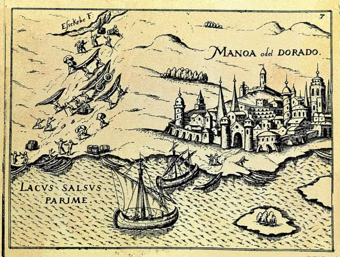
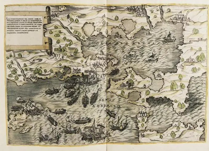
A collection of antique maps depicting various regions of Europe, showcasing historical battles, cities, and geographic features from the 16th and 17th centuries.

Barbarossa, Khayr ad-Dn (1483-1546). Turkish sailor and pirate, one of the founders of Alger. Barbarossa's fleet in Dardanelles. FRANCE. ‘LE-DE-FRANCE. Paris. National Library.
246 assets in this story
4048-4841
The American Revolution. The Battle of Valcour Island, Lake Champlain, Vermont. William Faden, 1776
6145-29095867
1945 Miller Map of Cape Cod, Massachusetts
6145-59098262
Prussia, Vistula Lagoon, Baltic Sea Bay; Glassbach, Christian Benjamin (1724-1779), PFAU, Theodor Philipp Von (1725-1794); 1770-1772 (1770-00-00-1772-00-00);
6145-54267753
Lesser Sunda Islands, distribution of population. Includes location map, reliability chart, and 2 insets : Distribution of Chinese -- Distribution of Europeans. ʺNo. 6467.ʺ... , Lesser Sunda Islands  ,area
4443-21208221
Maps of Kos and Chios, Jan Luyken, Cornelis Boutesteyn, Jordaan Luchtmans, 1692
6145-55914875
A map of the Maine coast from York Harbor to Saco Bay : reminiscent & actual. Relief shown pictorially. Includes illustrations. Illustrated border.... , Maine
6145-43494015
Map Sampler (England); Embroidered by Elizabeth Milner (English); School of Mrs. Watson; silk embroidery on linen foundation; 42 x 44.5 cm (16 9/16 x 17 1/2 in.); Bequest of Mrs. Henry E. Coe; 1941-69-24
6145-50567317
Carte de la Nouvelle-France, augmentée depuis la derniere, servant a la navigation faicte en son vray Meridien par le Sr. de Champlain capitaine pour le Roy en la Marine lequel depuis, l'an 1603, jusques en l'anneé 1629; a descouvert plusieurs costes terres, lacs rivieres et nations de sauvages par cy devant incognues comme il se voit en ses relations quil a faict imprimer en 1632 , Canada, Maps, Canada, Eastern, Maps, Early works to 1800, Facsimiles, East U.S., Maps, Early works to 1800, Facsimiles, North America, Discovery and exploration, Maps, New France, Discovery and exploration, Maps Norman B. Leventhal Map Center Collection
1848-50226823
Plan of the Battle of Belgrade of 16 August 1717, Historical, digitally restored reproduction of a 19th century original, exact date unknown
6145-55914617
A map of Portland Maine and some places thereabout. Oriented with north to the upper right. Some buildings shown pictorially. Includes notes about locations or historic events. Border includes 5 maps, 13 illustrations of buildings or places, and illustration of the city seal. Maps in border: Sebago Lake -- A mappe of the Kennebunks -- Falmouth Neck 1775 as it was when destroyed by Mowett -- A mappe of Cape Elizabeth -- A mappe of Prout's Neck. "Copyright 1928, the Tudor Press, Boston."... , Maine  , Cumberland  ,county   , Portland
6145-51395744
Nantucket , Nantucket Island Mass., Maps Norman B. Leventhal Map Center Collection
6145-55956309
Map of America Wilson, H.. Cartographic. Maps. 1804-09-04. Lionel Pincus and Princess Firyal Map Division. America , Maps
6145-54602799
Midsummer's marvels
6145-48719233
Lesser Sunda Islands, distribution of population , Population density, Lesser Sunda Islands, Maps, Chinese, Lesser Sunda Islands, Population, Maps, Europeans, Lesser Sunda Islands, Population, Maps, Lesser Sunda Islands, Maps Norman B. Leventhal Map Center Collection
6145-55914674
A map of the Bermuda Islands : ya des demonios, isles of the devils. Relief shown pictorially. At head of title: The Sommer Islands. Includes illustrations, notes and decorative border. Text on verso. A picture history map. In a decorated envelope.. Women were very active in the production of pictorial maps in the early 20th-century. These whimsical maps frequently focused on travel and tourism. Bordered by a ribbon of ocean creatures, this 1930 map of Bermuda illustrates various methods of transportation from horse-drawn carriages to pirate ships and airplanes. On shore, tourism reigns with beaches, golf courses, tennis courts, shooting ranges and historic forts. Designed by Elizabeth Shurtleff and Helen McMillin, who studied at the Boston Museum School of Fine Arts and Wellesley College respectively, this map encourages visits to the island by promoting recreation and history.. Bermuda Islands. Bermuda Islands, Bermuda  ,territory
6145-51396158
A map of the Bermuda Islands : ya des demonios, isles of the devils , Bermuda Islands, Maps, Pictorial maps Norman B. Leventhal Map Center Collection
6176-66092950
Vintage Pictorial Map of Los Angeles,  California, 1871.
6145-48827121
Tewarich-i al-i Osman
4409-20919703
PORTULANO MAR EGEO TURQUIA Y GRECIA S XVI. Author: DIOGO HOMEN (1521-1576). Location: MUSEO NAVAL / MINISTERIO DE MARINA. MADRID. SPAIN.
4408-18603
Ancient Middle East, People & Places
6145-48672953
Map of Mt. Desert Island, Maine , Tichnor Brothers Collection, postcards of the United States
4409-20921235
PUERTOS Y PASOS QUE VIENEN DE FRANCIA A BAZTAN. Author: PEDRO TEIXEIRA (1592-1662) PEDRO TEXEIRA. Location: ARCHIVO-COLECCION. Simancas. Valladolid. SPAIN.
6145-55913927
Historic Massachusetts : a travel map to help you feel at home in the Bay State. Pictorial map. Indexed. Includes notes, pictorial index to points of interest, color illustrations, and inset: "Massachusetts year round vacation areas, from the World's Fair to Massachusetts." Mileage chart, recreation area table, covered bridge index, calendar of events, text, illustrations (some color), and outline map of Massachusetts with pictorial index to points of interest on verso. "Massachusetts Pavilion, New England States Exhibition New York World's Fair 1964-65." "4-64-937759.".. World of fun and relaxation - Massachusetts, the historic vacationland. World of fun and relaxation - Massachusetts, the historic vacationland, Massachusetts
1525-21261548
Beautiful old brass compass over antique Thailand map
1788-38551
Italy - Tuscany region - Florence. Palazzo Vecchio, Hall of the Geographical Maps. Map of Turkey and Cyprus, oil painting by Stefano Buonsignori 1575-1584.
6145-54267713
Java and Madoera principal estate regions showing major products. Includes regional map and reliability of data. "No. 6441."... , Indonesia  , Java  ,island
6145-50568757
Historic Massachusetts : a travel map to help you feel at home in the Bay State , Massachusetts, Maps Norman B. Leventhal Map Center Collection
6145-51394561
A map of Cape Cod , Cape Cod Mass., Maps, Pictorial maps Norman B. Leventhal Map Center Collection
6145-29095686
1883 U.S.G.S. Map of the Hawaiian Islands
4409-19365
GRABADO-CIUDAD DEL MANOA O EL DORADO-TRANSPORTE DE BARCAS. Location: BIBLIOTECA NACIONAL-COLECCION. MADRID. SPAIN.
6145-51397781
Olde York County Maine : published in commemoration of the 300th anniversary , York County Me., Maps, York County Me., History, Maps Norman B. Leventhal Map Center Collection
6145-55915879
Olde York County Maine : published in commemoration of the 300th anniversary. Pictorial map printed in black and red showing historical and geographical points on interest. On verso: text of the York County Maine Tercentenary program, from Thurs. Aug. 20-Sat. Aug. 29, 1936. Panel on verso: Welcome, 1636-1936, York County Maine Tercentenary... Pictorial map of old York County Maine. Pictorial map of old York County Maine, Maine  , York  ,county
6145-58841949
Map of Gothenburg, Anonymous, 1735 Map of the reinforcements around the Swedish city of Gothenburg. Part of an atlas with 223 maps of countries and cities and war scenes in Europe in the period ca. 1690-1735. print maker: Northern Netherlandspublisher: Amsterdam paper etching / engraving / lacquering  Gothenburg Map of the reinforcements around the Swedish city of Gothenburg. Part of an atlas with 223 maps of countries and cities and war scenes in Europe in the period ca. 1690-1735. print maker: Northern Netherlandspublisher: Amsterdam paper etching / engraving / lacquering  Gothenburg
6145-29096388
1810 Whimsical Schoolgirl &Hartshorn& Map of Newfoundland
1848-50195441
Historical map of Africa after Juan de la Cosa, c. 1500, Historical, digitally restored reproduction of a 19th century original, exact date unknown
6145-55167075
Historic Niagara Frontier. Includes illustrations and notes of historical events.... , Niagara River
1486-15802
Map of Roatan in the Mahogany Bay Cruise Center, Roatan Island, Honduras
6145-51395087
Map of the state of New Hampshire : looking over our whole country from east to west, let me ask if such a map was ever before presented to the eye - Daniel Webster , New Hampshire, History, Maps, New Hampshire, Humor, Maps Norman B. Leventhal Map Center Collection
6145-51929738
Boston shoreline 1950. Cartography by Herb Heidt and Eliza McClennen of MapWorks for Mapping Boston edited by Alex Krieger and David Cobb with Amy Turner. Cambridge, MA : MIT Press, 1999.... , Massachusetts  , Suffolk  ,county   , Boston
6145-50568690
Route and pictorial map of Maine , Maine, Maps, Roads, Maine, Maps, Recreation, Maine, Maps Norman B. Leventhal Map Center Collection
1848-49391988
Personified map, c. 1880, Denmark, depicted with a noblewoman, Historical, digitally restored reproduction from a 19th century original, Europe
6145-50568887
Frontier, Montana, pioneer : a one page history dedicated to the Old Timers , Montana, Historical geography, Maps Norman B. Leventhal Map Center Collection
6145-29095843
1932 Walter M. Gaffney Map of Cape Cod, Massachusetts
6145-59435895
Two fragments of a map of the Cantons Zurich and Basel, Abraham van den Broeck, 1626 - 1665 print Two fragments of a map of the Cantons Zurich and Basel stuck together.  paper engraving maps of cities
6145-51394989
Map of the island of Tangerina and Wild Island , Dragons, Juvenile fiction, Imaginary places, Maps, Pictorial maps Norman B. Leventhal Map Center Collection
6145-50567716
Map of the island of Tangerina and Wild Island , Dragons, Juvenile fiction, Imaginary places, Maps, Pictorial maps Norman B. Leventhal Map Center Collection
PREVIOUS
of 3
NEXT
2401 S. Ervay, Suite 206
Dallas, Texas 75215
United States
Get Started
Free ResearchMy BoardsMy Cart
For Creators
How To License Your ContentContributor PortalFrame of Mind
Resources
API accessPricing
Contact
+1 866 236 0087help@viewpictures.co.uk Contact form
©2026 View Pictures. All Rights Reserved. -A
This site is protected by reCAPTCHA and Google Privacy Policy and Terms of Service apply.