My Boards
View Pictures
  • My Boards
← Documents & Records

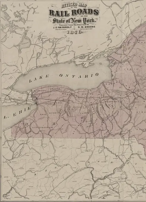
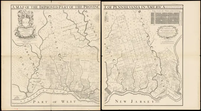
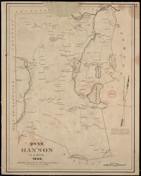
Historical Maps of the Mid-Atlantic

Detailed historical maps depicting Pennsylvania, Maryland, Delaware, and the Carolinas, showcasing county lines, roads, and natural features from early surveys.

Map of Boston and its vicinity : from actual surveys , Boston Mass., Maps Norman B. Leventhal Map Center Collection
241 assets in this story
6145-52360117
A map of Maryland with the Delaware counties and the southern part of New Jersey &c. Cartographic. Maps. 1757. Lionel Pincus and Princess Firyal Map Division. New Jersey, Delaware, Maryland
6145-54268226
A new map of the western rivers, or, Travellers guide : exhibiting the Mississippi, Missouri, Ohio, and Illinois rivers with all the principal towns, islands & distances. Includes distance list. Text on verso.. America Transformed: This map, designed for travelers, compressed the Mississippi River and its major tributariesthe Ohio, Illinois, and Missourionto one compact sheet, providing a succinct guide to towns and distances along the navigable portions of the rivers. The Mississippi River and its tributaries provided transportation arteries for exploration, commerce, and travel. Starting in the early 19th century, steamboats dominated transportation on these navigable rivers. Canals, also introduced in the early 19th century, improved transportation, but they required significant investments into infrastructure. Steamboats, on the other hand, could travel on existing waterways and, unlike boats that relied on sails, against the current.. Travellers guide. Travellers guide, Mississipp
4443-75462402
Revised map of the railroads of the State of New York, issued in 1876. The map measures 71 x 85 cm, with an overall sheet size of 79 x 89 cm. It is hand-colored and depicts the railroads and canals of New York, along with administrative and political divisions. The location of issuance is Albany, N.Y
6145-50570798
Map of Hanover, Mass , Real property, Massachusetts, Hanover Town, Maps, Hanover Mass. : Town, Maps Norman B. Leventhal Map Center Collection
6145-50571158
CartedelaRussied'Europe,avecl'Empired'Autriche,laSuede,leDanemarketlaNorwege,laPrusse,leGrandDuche ́deVarsovie,lesprovincesIllyriennes,etunepartiedelaConfédérationduRhinetdelaTurquied'Europe,Russia,Maps,Austria,Maps,Scandinavia,Maps,Poland,Maps,Germany,Maps,Europe,Eastern,MapsNormanB.LeventhalMapCenterCollection
6176-66094472
vintage illustrated map of Maryland, USA 1931
6145-51388824
Vermont, from actual survey : with all the late additions & improvements , Vermont, Maps Norman B. Leventhal Map Center Collection
6145-55167659
Calvert's map of the lake region in New Hampshire, U.S.A.. Shows roads, railroads and steamboat lines. Relief shown by spot heights. Oriented with north toward the upper left. Includes profile view of the mountains as seen from Lake Winnepesaukee; advertisement for Armstrong's Railway dining rooms; and statistical tables, references and steamboat route distances for Lake Winnepesaukee and Asquam Lakes... Map of the lake region in New Hampshire. Map of the lake region in New Hampshire, New Hampshire  , Winnipesaukee, Lake
6145-52360084
New York and adjacent country. Cartographic. Maps. 1818. Lionel Pincus and Princess Firyal Map Division. New York (N.Y.), New York Region , Maps
6145-51393629
Indo-Chine, carte de la mission Pavie , Indochina, Maps Norman B. Leventhal Map Center Collection
6145-55914000
Indo-Chine, carte de la mission Pavie. Relief shown by hachures and spot heights.... , Indochina  ,area
6145-55915308
Mer Baltique : theatre de la guerre. Relief shown by hachures. Prime meridian: Paris. Includes inset: Kronschtadt. Includes text to left and right of the map. "Typ. L. Martinet."... , Russia  , Kronshtadt Baltic Sea
6145-46477109
Soldiers and allegorical show around Turkish Sultan; Magni Turcarum Domini Empire in Europe, Asia, et Africa (...). Around a stone with title Links soldiers with weapons and on the right an allegorical scene regarding the Turkish Sultan. Detail of a map of the Turkish empire in the Mediterranean with parts of Europe, North Africa and the Middle East.
4443-75464803
A map titled 'Mexico, or, New Spain,' created by John Seller around 1679. Published in London by J. Seller, this map is categorized under early works to 1800 for regions including Mexico, the Southern States, and the Caribbean Area. The map measures 8 x 6 cm
6145-51388182
Amplissimae regionis Mississipi seu provinciae Ludovicianae  R.P. Ludovico Hennepin Francisc. Miss. in America septentrionali anno 168 , United States, Maps, Early works to 1800, Louisiana, Maps, Early works to 1800, Mississippi River Valley, Maps, Early works to 1800 Norman B. Leventhal Map Center Collection
4443-75467298
Title page of 'Burgundiae Duc.' by James Shawe, 1603. Additional, 'The Duchye of Burgundie.' Printed in London by Ieames Shawe, sold at his shop near Ludgate. The text refers to subjects including atlases, geography, Norway, and Burgundy (France)
6145-55913648
Fac simile of Holmes' map of the Province of Pennsylvania : with the names of the original purchasers from William Penn, begun in 1681. Shows property lines and property owners in the southeast corner of Pennsylvania. Oriented with north towards the upper right. Inset: The City of Philadelphia. Includes dedication in cartouche. "Entered according to act of Congress, in the Year 1870, by Charles L. Warner, in the office of the Librarian of Congress, at Washington.".. Map of the improved part of the Province of Pennsilvania in America : begun by Wil. Penn Proprietary & Governor therof Anno 1681 Map of the province of Pennsilvania containing the three countyes or Chester, Philadelphia & Bucks : as far as uet surveyed and laid out ye divisions or distinctions made by ye different Coullers respects the settlements by way of townships / by Thos. Holme Survey Genl. Map of the improved part of the Province of Pennsilvania in America : begun by Wil. Penn Proprietary & Governor therof Anno 1681
6145-29096692
1696 Coronelli Map of the Great Lakes (Most Accurate Map of the Great Lakes in the 17th Century)
6145-54267413
Les costes aux environs de la Riviere de Misisipi : decouvertes par Mr. de la Salle en 1683 et reconnues par Mr. le Chevallier dIberville en 1698 et 1699. From: LAtlas curieux / N. de Fer. "122" in upper right margin.... , Mississippi River Southern United States  ,area
6145-54267874
Map of Madison and the Four Lake Country, Dane Co. Wis. Shows streets for city of Madison, roads, existing and proposed railroads. Oriented with north to the upper left. Includes references to city buildings and definitions of Indian Names. Imprint dated from text. In left and right margins: Madison, The capital of Wisconsin descriptive text.... , Wisconsin  , Dane  ,county   , Madison
6145-55957808
County of Monroe Cartographic. Maps. 1820. Lionel Pincus and Princess Firyal Map Division. Monroe County (N.Y.), Monroe County (N.Y.) , Population, Monroe County (N.Y.) , Administrative and political divisions, New York (State) , Monroe County
6145-48719301
Map showing the location of the land grant of the Flint & Pere Marquette Railway Company, in Michigan , Railroads, Michigan, Maps, Railroad land grants, Michigan, Maps, Real property, Michigan, Maps, Michigan, Maps Norman B. Leventhal Map Center Collection
6145-51388823
Vermont , Vermont, Maps, Early works to 1800, Vermont, Administrative and political divisions, Maps, Early works to 1800 Norman B. Leventhal Map Center Collection
6145-50533051
Bowles's new map of the River Thames, from it's spring in Gloucester-shire, to it's influx into the sea : with a table of all the locks, wears, and bridges thereupon ; shewing the tolls payable at each and their distance by water from one another , Thames River England, Navigation, Thames River England, Maps Norman B. Leventhal Map Center Collection
1899-41405
Map of China and Japan, circa.1760. From 'Atlas de Toutes Les Parties Connues du Globe Terrestre ' by Cartographer Rigobert Bonne. Published Geneva circa. 1760.
6145-29673095
Photo collection Government information service. De Schermer. undated
6145-51387614
Smith's topographical map of Virginia and Maryland , Virginia, Maps, Maryland, Maps Norman B. Leventhal Map Center Collection
4443-22024596
Lake Titicaca, Views of Inca and pre-Inca sites, Chalon, Paul Fédéric, 1846-1919, Lithography, 1872-1880, Album includes captioned drawings, lithographs, and albumen photographs documenting Inca and pre-Inca sites in modern Peru, Bolivia, and Ecuador.
4443-73257351
unknown, Carte de deux voies militaire des Romains, Map of two Roman military roads in the Netherlands, Map of the Roman military roads in the river area in the Netherlands., print, history print, map, prints, Frederik Muller Historical plates, height 296 mm, width 442 mm, print maker, printmaker, 1732 - 1734, second quarter 18th century, paper, etching, etchings, engraving, engraving (printing process), hand colouring
6145-50541597
Das Europäische Russland , Russia, Western, Maps Norman B. Leventhal Map Center Collection
6145-29094596
1852 Levasseur Map of Algeria
6145-54268656
Plan of Hanson made by Joshua Smith, dated 1830. See also v.9:p.1 no.2083.... , Massachusetts  , Plymouth  ,county   , Hanson
6145-48484571
N.N., Hydrographic map of Zeeland (1867): Seekarte of the Westerschelde fairway, scale bar. Pressure on paper, 94.2 x 127.8 cm (including scan edges) N.N. : Hydrografische Karte von Zeeland
6145-50567613
Birds eye view of North and South Carolina and part of Georgia , Confederate States of America, History, Aerial views, North Carolina, History, Civil War, 1861-1865, Aerial views, South Carolina, History, Civil War, 1861-1865, Aerial views, Georgia, History, Civil War, 1861-1865, Aerial views, United States, History, Civil War, 1861-1865, Aerial views Norman B. Leventhal Map Center Collection
6176-66914017
Map showing the route of the Continental Railway and its connecting lines, circa 1873
6145-48719024
Map of New England, 31st , New England, Maps, Boston Mass., Maps Norman B. Leventhal Map Center Collection
6145-51391537
Birds eye view of North and South Carolina and part of Georgia , Confederate States of America, History, Aerial views, North Carolina, History, Civil War, 1861-1865, Aerial views, South Carolina, History, Civil War, 1861-1865, Aerial views, Georgia, History, Civil War, 1861-1865, Aerial views, United States, History, Civil War, 1861-1865, Aerial views Norman B. Leventhal Map Center Collection
6145-55913693
Fowler's new map of the Hudson River : with a description of the adjoining country : the distances of the different towns, &c. on the Canal, from Albany to Buffalo, the distances of the different towns from Albany, by stage, to Niagara Falls, Lake George, &c. Published as a broadside with map comprising the center column flanked by one column of text on each side. Relief shown by hachures and spot heights. Includes descriptive text and mileage charts... New map of the Hudson River. New map of the Hudson River, Hudson River New York
6145-48559619
Plan of Manchester made by Philander Anderson, dated December 1830 ,. Massachusetts. Office of the Secretary of State
6145-29882641
Norman Kamps, Map, 1935 1942 Map
6239-70888856
South Dakota; Mining Village, Black Hills; Prairie Farming; Harrowing  | Library of Congress
PREVIOUS
of 3
NEXT
2401 S. Ervay, Suite 206
Dallas, Texas 75215
United States
Get Started
Free ResearchMy BoardsMy Cart
For Creators
How To License Your ContentContributor PortalFrame of Mind
Resources
API accessPricing
Contact
+1 866 236 0087help@viewpictures.co.uk Contact form
©2026 View Pictures. All Rights Reserved. -A
This site is protected by reCAPTCHA and Google Privacy Policy and Terms of Service apply.