My Boards
View Pictures
  • My Boards
← Documents & Records

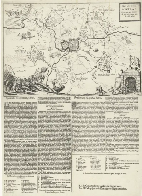
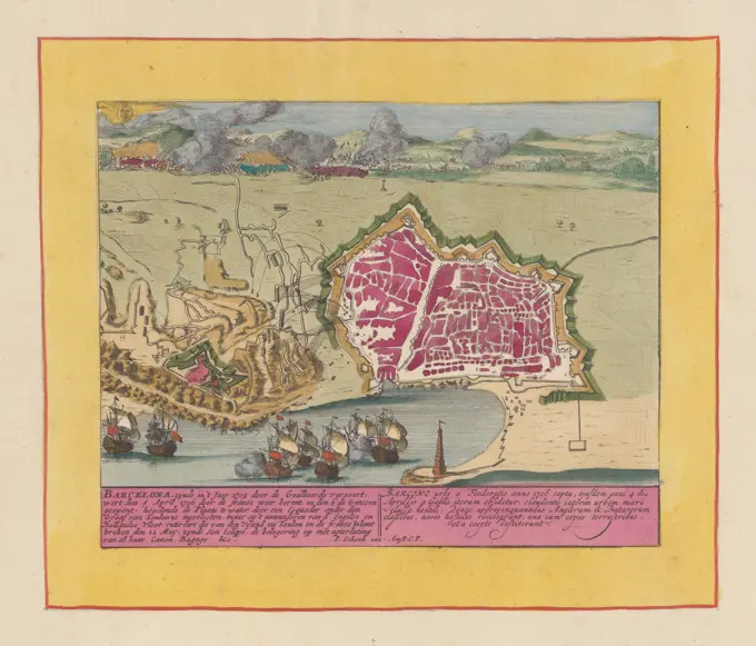
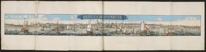
Historical Siege and Battle Engravings

Engravings depicting key historical sieges and battles across Europe, with detailed illustrations and captions in multiple languages, offering a glimpse into military history.

Intake of Ruhrort, 1587, 1587 - c. 1591 print Ruhrort conquered from the troops of Schenck, January 1587. Episode from the Keulse War. With caption of 14 lines in German. Nummered in the bottom left: 243. The print is part of an album. Cologne paper etching capture of city (after the siege) Ruhrort
263 assets in this story
4443-73198133
Autotype Company, The, Reproduction of five drawings of buildings in Pontefract, recto - printed, photomechanical print, reproduction, page, photographs, photographically illustrated books, From 'A Comprehensive Dissertation on the Ancient and Present State, of Ponterfact' in the Appendix to 'Historia Compendiosa Romana, 'by, Thomas Gent. (See pp. 417-418.), height 210 mm, width 120 mm, photographer, 1882 - 1887, paper, collotype, photoprint, cliché maker, intermediary draftsman
6145-59241992
Plans of Viviers, Jametz, Moyenvic and Remiremont, ca. 1702, 1702 - 1703 print Leaf with four floor plans of the defenses around the places Viviers, Jametz, Moyenvic and Remiremont. Plate no. 50 in the printed work consisting of a total of 276 numbered plates of renowned strong cities and fortresses in the context of the Spanish Succession War. For the most part these records have been copied to the anonymous French records: in Les Forces de l'Europe and in: Le Theater de la Guerre, Dans Les Pays-Bas, both originally published by Nicolas de Fer in Paris (1693-1697) in the framework of the nine -year war. Titles and inscriptions in the plate in French. print maker: Northern Netherlandspublisher: Amsterdam paper etching maps of cities. fortress Viviers. Jametz. Moyenvic. Remiremont
6145-45696385
Stage of the war (leaf XVIII), 1717; Krygs table, which shows in the main places, which conquers through the Kyserlyke, from the Turks in Desen War; all sides of life signed; Spectee of the war starts with King Charles the second existence in battles, and sisters, so as to water as the landscape, with the main fortresses (...). Sheet with nine performances of events from the year 1717 in the war against the Turks (1716-1718) including some cards. Inscriptions in the show in Dutch and Latin. Plate 17 in the printing with the bundled series of 33 plates with performances (the majority divided into 9 smaller scenes) of events from the years 1700-1727 of the Spanish Succession War and the years thereafter, maps and floor plans.
6145-52854482
Etching by Matthäus Merian the Elder showing a 17th-century map of Milan with streets, city blocks, rivers, and surrounding topography.
6145-45676387
Map of the Rheinfels Castle, Besieged by the French in 1692-1693; Rhynfels (where By 't Steedje St. Goar) a strong castle in Germany (...) End of the year 1692 by the French besieged; but in the early 1693 by the self-emerging shameful; Rhinfels (Pres de la Petite Ville de St. Goar) Chteau Tres Fort d'Allemagne (...). Map of the Rheinfels Castle Located on the Rhine at the town of Sankt Goar, Besieged by the French in the end of 1692 but the siege stops January 1, 1693.
6145-45607588
Conquest of the silver fleet in the Bay of Matanzas by Admiraal Piet Heyn, 1628; Greybung / von Erobung der Span N Ischen Silber Flotta / Who Solicche / Vom Dem General Peter Peters Heyn. In Nova Hispania / in Der Insul Cuba im Baia Matanckha / Ist erobert becomes Anno 1628. Conquest the silver fleet in the Bay of Matanzas by a fleet of the WIC under the command of Admiraal Piet Heyn, September 8, 1628. At the bottom left a map of the island Cuba. At the top Round Portraits of Admirals Hendrick Cornelisz. LONCQ and Piet Heyn. Printed on the blade under the show A description of the events in 3 columns with the legend 1-20 in German, followed by three columns with a loot by ship.
4443-73236959
Amsterdam, Danckerts, Cornelis (I), Northern Netherlands, Plan du Siege d'Arras Pris par les Armes du Roy de france le 10. d'Aoust 1640, Siege and conquest of Arras by the French, 1640, Map of the siege and conquest of Arras (Arras) by the French from Spain, 13 July - 10 August 1640. Map with the city in the middle, around it the positions of the besieging troops. At the bottom the events are depicted as a battle between cats (Spain) and rats led by a rooster (French). Glued below the print is a text printed in 2 columns in Dutch and 2 columns in French with an explanation of the numbers 1-9 and the letters AH., print, prent, nieuwsprent, kaart, prints, prenten, Frederik Muller Historieplaten, height 540 mm, width 389 mm, print maker, prentmaker, 1640 - 1640, second quarter 17th century, tweede kwart 17e eeuw, paper, papier, etching, etchings, letterpress printing, boekdruk, Publication (Event), Publicatie, 1604-06-13 - 1656-04-27, publisher
6145-59603011
Map of Gorinchem, Anonymous, 1632 print At the top left a legend 1-8. At the top right the city coat of arms.  paper etching maps of cities. fortified city Gorinchem
6145-45738918
View of the Chteau de Miolans, 1693; Veue du Chateau de Miolans and Savoy (...); Les Forces de l'Europe, Ou Description des Principales Villes, Avec Leurs Fortifications: Dessignées PAR LES MEILLEURS Engineers, private party Celles (...) De La France, Dont Les Plans DEVEÉ LEVEZ PAR M. DE VAUBAN. View of the French Chteau de Miolans, near Montmélian. Part of the second part (1693) of the picture in which bundles are the eight parts of Les Forces de l'Europe issued between 1693-1697. The printing works consists of 175 plates with plans (from Sébastien Le Preterre, Seigneur de Vauban) from renowned strong cities and fortresses in the nine-year war. Title and inscriptions in French.
6145-59245155
Siege of Bergen op Zoom, 1747, 1747 print Ticket with the siege of the city of Bergen op Zoom by the French, July-September 1747. In the caption a breach of the city and he siege in German. In the cartouche at the top right the title and the legend 1-19. Augsburg paper etching fortress. Victory, position was Bergen op Zoom
6145-59404872
Performances from national history, Johan Christoffel Schultz, 1789 print Title page, various historical representations and a map of the Netherlands from an Almanak from 1789. Amsterdam paper etching / brush maps of separate countries or regions
6145-59595091
Map of Amsterdam, 1544 (tenth part), Cornelis Anthonisz., C. 1557 print Tenth part of a map of Amsterdam in a nutshell perspective, consisting of eleven parts (twelfth part is missing).  paper  maps of cities. sailing-ship, sailing-boat Amsterdam
6145-59475164
Intocht in Jeruzalem, Melchior Küsel (I), after Johann Wilhelm Baur, 1682 print Text in German in the lower margin. Numbered in the bottom right: 19. Print is part of an album. Augsburg paper etching Palm Sunday
6145-45654400
Map of the Fort Mont Royal, 1693; Mont Royal, Est Une Fortresse Nouvelle (...); Les Forces de l'Europe, Ou Description des Principales Villes, Avec Leurs Fortifications: Dessignées PAR LES MEILLEURS Engineers, private party Celles (...) De La France, Dont Les Plans DEVEÉ LEVEZ PAR M. DE VAUBAN. Map of the Fort Mont Royal in a bend of the Mosel. Part of the second part (1693) of the picture in which bundles are the eight parts of Les Forces de l'Europe issued between 1693-1697. The printing works consists of 175 plates with plans (from Sébastien Le Preterre, Seigneur de Vauban) from renowned strong cities and fortresses in the nine-year war. Title in French.
6145-58837814
Siege of Barcelona, 1706, 1707 - 1720 Map of Barcelona besieged by the French army and relieved by the Allies, 12 May 1706. Under the performance an explanation in Dutch and Latin. Print is part of an album. print maker: Amsterdampublisher: AmsterdamThe Hague paper etching  Barcelona Map of Barcelona besieged by the French army and relieved by the Allies, 12 May 1706. Under the performance an explanation in Dutch and Latin. Print is part of an album. print maker: Amsterdampublisher: AmsterdamThe Hague paper etching  Barcelona
6145-59241739
Eighth plate with text and trenches at a Bastion, 1693, 1693 print Eighth plate with text and trenches at a bastion. Part of the first part (1693) of the print work in which the eight parts of Les Forces de l'Europe are published between 1693-1697. The printed work consists of 175 plates with plans (from Sébastien Le Prestre, Seigneur de Vauban) of renowned strong cities and fortresses in the Nine Years War. Title in French. print maker: Francepublisher: Paris paper etching / engraving fortifications, military engineering
6145-59232674
Morals of the old Germanen, 1615 - 1617 print Leaf with six separate performances, printed from two plates with three scenes each. Ticket of the Netherlands with surrounding countries and five performances with Latin captions of Germanic customs for sacrifices, meals, funeral and war. Take leaf from a book, with text on the back. Coming from: Pieter van den Keere, Germania Inferior ID Est, XVII Provinciarum ejus Novæ et Exactæ Tabulæ Geographicæ, Pieter van den Keere, Amsterdam 1617-1622. Netherlands paper etching extinct, 'historical' peoples (with NAME) Netherlands
6145-45651176
The Spanish Furie in Antwerp in 1576; True KontraFactur Der Statt Antorff Sambt Darin Submersible Hanndlungen Anno 1576 den 4 November .. Combined show on one sheet of seven episodes from the Spanish Furie in Antwerp 4-5 November 1576. In the middle the plan of the city; at the top side by side: Spanish Government deposited in Brussels and shooting Antwerp by Spanish troops; In addition to the left plan: Furie on the street, right: city dwellers flights in the Scheldt; At the bottom left: Furie on the market; Right: murder of street and atrocities and torture in the houses.
6145-59242140
Plattegrond van Casale Monferrato, ca. 1702, 1702 - 1703 print Map of the reinforcements around the Italian city of Casale Monferrato. Plate no. 181 In the printed work consisting of a total of 276 numbered plates of renowned strong cities and fortresses in the context of the Spanish Succession War. For the most part these records have been copied to the anonymous French records: in Les Forces de l'Europe and in: Le Theater de la Guerre, Dans Les Pays-Bas, both originally published by Nicolas de Fer in Paris (1693-1697) in the framework of the nine -year war. Title and inscriptions in the album in French. print maker: Northern Netherlandspublisher: Amsterdam paper etching maps of cities. fortress Casale Monferrato
6145-59242809
View of Heidelberg, 1726, 1726 print View of the German city of Heidelberg, in the foreground the big barrel. Plate no. 180 In part VIII of the print work: Les Forces de l'Europe, Asie, Afrique et Amerique ... Comme Aussi Les Cartes des Côtes de France et d'Espagne from 1726, this first part with 238 by hand numbered Plates of renowned strong cities and fortresses in the context of the Spanish War of Succession 1701-1713. For the most part, these records have been copied to the anonymous French records of renowned strong cities and forces: in Les Forces de l'Europe and in: Le Theater de la Guerre, Dans Les Pays-Bas, both originally published by Nicolas de Fer in Paris (1693-1697) in the context of the Nine Years' War. Titles and inscriptions in French. Right track of the numbered number: 97. print maker: Northern Netherlandspublisher: Leiden paper etching  Heidelberg
6145-46057845
Schuttershandje van Kapitein Pieter Clockener, CA. 1787. Schuttersbrief from the Captain Company of Captain Pieter Clockener in Amsterdam, approx. 1787. Univelled convocation note for the guard in Wijk No 5. With a map of the neighborhood located between Nieuwmarkt and Damrak, at the top The names of other officers of the Compagnie.
6145-45893441
For the earth's position of seem to victims of the plague. A number of men are busy seem to bury victims of the plague. The text above the print describes that the remains will be buried deeply at least 12 feet and that they are sprinkled with lime to speed up the dissolution process.
6145-43507379
Bound Print (France)
6145-59234828
Conquest of San Salvador in Brazil by Admiraal Jacob Willekes, 1624, 1624 print The conquest of San Salvador in Brazil by Admiraal Jacob Willekes for the WIC, 10 May 1624. View of the city and forts at the entrance of the bay from which the Dutch fleet is shot. At the bottom left a bet with a ticket from the larger area. Under the plate, a text with the legends 1-22 and A-B in 5 columns in Dutch. Amsterdam paper etching / letterpress printing battle (+ naval force). capture of city (after the siege) Salvador
6145-59242045
View of Heidelberg, ca. 1702, 1702 - 1703 print View of the German city of Heidelberg, in the foreground the big barrel. Plate no. 97 In the printed work consisting of a total of 276 numbered plates of renowned strong cities and fortresses in the context of the Spanish Succession War. For the most part these records have been copied to the anonymous French records: in Les Forces de l'Europe and in: Le Theater de la Guerre, Dans Les Pays-Bas, both originally published by Nicolas de Fer in Paris (1693-1697) in the framework of the nine -year war. Title and inscriptions in the album in French. print maker: Northern Netherlandspublisher: Amsterdam paper etching  Heidelberg
4443-22030050
Babilonia seu Babilon, Registrum huius operis libri cronicarum cu, m, figuris et ymagi, nibus ab inicio mundi, Pleydenwurff, Wilhelm, d. 1494, Schedel, Hartmann, 1440-1514, Woodcut and letterpress, 1493
6145-29670860
Photo collection Government information service. engraving. 1860. Leiden, South Holland
6145-59231590
The Spanish Furie in Antwerp in 1576, Frans Hogenberg (Attributed to), after Frans Hogenberg, 1577 print Combined show on one sheet of seven episodes from the Spanish Furie in Antwerp 4-5 November 1576. In the middle the plan of the city; At the top next to each other: Spanish government in Brussels deposited and the shooting of Antwerp by Spanish troops; Next to the Left plan: Furie on the street, right: city dwellers flee in the Scheldt; At the bottom left: Furie on the Markt; Right: Murder on the street and atrocities and torture in the houses. Cologne paper etching massacre ~ war. maps of cities Antwerp
6145-44205222
Plan of exille with attacks of allies the year 1708 or the Guarnnon has been taken prisoner of war
6145-45831152
Floor plans of Viviers, Jametz, Moyenvic and Remiremont, ca. 1702; Viviers / Jametz / Moyenvic / Remiremont; Les Forces de l'Europe, Asie, Afrique et Amerique, Ou Description des Principales Villes Avec Leurs Fortifications. Dessignées PAR LES MEILLEURS Engineers, private party Celles Qui Sont Sous La Domination de la France (...) Et Ornées the plusieurs Superbes Edifes. Leaf with four floor plans of the defenses to the places Viviers, Jametz, Moyenvic and Remiremont. Plate No 50 in the picture in the context of a total of 276 numbered plates of renowned strong cities and fortresses in the context of the Spanish Succession War. For most part, these plates have been copied to the anonymous French plates: in Les Forces de l'Europe and in: Le Theater de la Guerre, Dans Les Pays-Bas, both originally published by Nicolas de Fer in Paris (1693-1697) in the framework of the nine-year war. Titles and inscriptions in the plate in French.
6145-30311375
Ansicht von Jassi Iași, Erobert I have , April , Unknown
6145-45755149
Fort Sint-Anthonie, 1629; Castellum minus, Anteportam Vuchteram, Vulgo Divi Antonii Dictum / Le Fort St. Antoine. Fort Sint-Anthonie, 1629. A Spanish fortress outside the city, during the topping through the state army under Frederik Hendrik, from 1 May to September 17, 1629.
6145-59242327
Schouwburg van den War (page XIII), 1712, 1720 - 1722 print Leaf with nine performances of events from the year 1712 of the Spanish Succession War and maps of amplified cities. Page XIII in: Schouwburg van den War (edition of 1720), the print work with the bundled series of 31 plates about the Spanish Succession War. Amsterdam paper etching maps of separate countries or regions. maps of cities. fortress. battle (+ land forces) Arras. Porto Ercole. Quesnoy, the. Knokke
6145-59238221
The State Army under Maurits stationed at Wesel, 1620, 1620 print Map of Wesel aan de Rijn and surroundings with the army place of the State Army under Maurits, 1620. Tour of Prince Maurits against Spinola, 15-23 August 1620. Bottom left a bet with a map of Rijnland. A printed description in 5 columns around the show. Amsterdam paper etching / letterpress printing maps of separate countries or regions. troop movements, transportation Wesel
6145-59238452
Siege of Schans Papenmuts, 1622, 1622 print Siege of Schans Papenmuts through the Duke of Neuburg for the king of Spain, from July 25, 1622. View of the fort on an island in the Rhine and the shelling from the other side. At the top a few cartouches with the larger area of Rijnland on the right. Under the plate a description of the events and the legend 1-11 in 3 columns in Dutch. Amsterdam paper etching / letterpress printing Victory, position was Schans Papenmuts
6145-59556487
Map of the Netherlands, C. Thierry, 1823 print Map of the Netherlands, placed against a whale and a bridge or dam with books placed on it. Around the map are instruments, weapons, skating, pipes, a heron and other objects.  paper etching maps of separate countries or regions. symbols of particular nations, states, districts, etc.. swimming mammals: whale
6145-59242112
Map of Batavia, ca. 1702, 1702 - 1703 print Map of the Batavia in the East Indies. Plate no. 157 In the printed work consisting of a total of 276 numbered plates of renowned strong cities and fortresses in the context of the Spanish Succession War. For the most part these records have been copied to the anonymous French records: in Les Forces de l'Europe and in: Le Theater de la Guerre, Dans Les Pays-Bas, both originally published by Nicolas de Fer in Paris (1693-1697) in the framework of the nine -year war. Title and inscriptions in the album in French. print maker: Northern Netherlandspublisher: Amsterdam paper engraving maps of cities Batavia
6145-59586068
Map of the fortifications to Nijmegen designed by Menno van Coehoorn in 1702, Anonymous, 1721 - 1774 print Map of Nijmegen on the Waal with the planned new fortifications designed by Menno Baron van Coehoorn in 1702. In the middle a bowl: 100 Rynandtse rods.  paper etching / engraving maps of cities. fortress Nijmegen
6145-45629770
Marly Machine, 1726; La Machine de Marly; Les Forces de l'Europe, Asie, Afrique et Amerique (...) Comme Aussi Les Cartes des Côtes de France et d'Espagne. Marly Machine. Pump installation completed in 1684 to pump water from the Seine to the gardens of the Palace of Versailles. Plate No. 58 In Part III of the Picture: Les Forces de l'Europe, Asia, Afrique et Amerique ... Comme Aussi Les Cartes des Côtes de France et d'Espagne from 1726, this first part with 238 by hand Numbered Plates of renowned strong cities and fortresses in the context of the Spanish Succession War 1701-1713. For most part, these plates have been copied to the anonymous French plates of renowned strong cities and fortresses: in Les Forces de l'Europe and in: Le Theater de la Guerre, Dans Les Pays-Bas, both originally published by Nicolas de Fer in Paris (1693-1697) In the context of the nine-year war. Title and inscriptions in French.
6145-45696384
Stage of the war (blade XIV), 1713; Spectee of the war starts with King Charles the second existence in battles, and sisters, so as to water as the landscape, with the main fortresses (...). Sheet with nine performances of events from the year 1713 of the Spanish Succession War and of floor plans of fortified cities. Inscriptions in the show in Dutch and Latin. Plate 13 in the picture with the bundled series of 33 plates with representations (the majority divided into 9 smaller scenes) of events from the years 1700-1727 of the Spanish Succession War and the years thereafter, maps and floor plans.
6145-59240633
Map of Coevorden, 1672, 1673 - 1699 print Map of the Fortress of Coevorden, on December 30, 1672 by the troops under the leadership of Karl Rabenhaupt conquered on the troops of the bishop of Munster. Bottom left the Legenda A-E in Dutch. Low Countries paper etching maps of cities Coevorden
6145-59595766
Fortress map of Philippine, Fort Liefkenshoek, Ravenstein and Helmond, Anonymous, c. 1698 - c. 1710 print At the top left a Fortress Plan of Phillippine. Bottom left a Vesting Floor Plan of Fort Liefkenshoek. At the top right a Vesting Floor Plan from Ravenstein. In the middle above a title cartouche. At the top left of the weapon of Brabant and the top right the weapon of Kleef. At the bottom right a Vesting Floor Plan from Helmond. At the bottom left a title cartouche. At the top left the weapon of Helmond.  paper etching / engraving maps of cities. coat of arms (as symbol of the state, etc.) (+ city; municipal). coat of arms (as symbol of the state, etc.) (+ province; provincial). fortress Philippine. Ravenstein. Helmond. Fort Liefkenshoek
6145-45674728
The State Army under Maurits Leged at Wesel, 1620; True Af-image of the entire army of the E.H. Lord States / Under 't Meterte Van His prin. Excellence Mauritius by Nassau / Prince from Orangien etc. Mitsgaders The straight gelegentheyt der Stadt Wesel and the haer surrounding plastation. Map of Wesel aan de Rijn and surroundings with the campaign of the State Army among Maurits, 1620. Tour of Prince Maurits against Spinola, 15-23 August 1620. At the bottom left of a commitment to a map of Rhineland. To the show a printed description in 5 columns.
6145-52795305
Copper engraving and etching depicting a map of Amsterdam from 1612, showing streets, canals, buildings, and topographical features. Produced between 1635 and 1667, emphasizing urban layout and cartographic detail.
6145-59242130
View of the Château de Miolans, ca. 1702, 1702 - 1703 print View of the French Château de Miolans, near Montmélian. Plate no. 169 in the prints consisting of a total of 276 numbered plates of renowned strong cities and fortresses in the context of the Spanish Succession War. For the most part these records have been copied to the anonymous French records: in Les Forces de l'Europe and in: Le Theater de la Guerre, Dans Les Pays-Bas, both originally published by Nicolas de Fer in Paris (1693-1697) in the framework of the nine -year war. Title and inscriptions in the album in French. print maker: Northern Netherlandspublisher: Amsterdam paper etching fortress Savoye
6145-58834171
San Pietro in Montorio Te Rome, Giovanni Battista Fonda, 1669 - 1670 Title and an explanatory list of numbers in the lower margin. Print is part of an album. print maker: Italyafter drawing by: Italypublisher: RomeVaticaanstadRomeVaticaanstad paper etching  San Pietro in Montorio Title and an explanatory list of numbers in the lower margin. Print is part of an album. print maker: Italyafter drawing by: Italypublisher: RomeVaticaanstadRomeVaticaanstad paper etching  San Pietro in Montorio
6145-55961073
Arx Babylonica à Semiramide, exstructa.. Kircher, Athanasius, 1602-1680. Janssonius van Waesberge, Johannes, 1616-1680. Books. 1679. General Research Division. Rare books, Forts & fortifications, Babylon (Extinct city)
6145-59440349
Map of Coevorden, Hendrik Hofsnider, 1743 print Two prints on one leaf: at the top a print with a representation of a Coevorden map and below a print with the title in a cartouche. In the upper print at the top of a part of the title on a ribbon, below a legend and a bowl at the bottom right. Top left: bl. 245. Groningen paper etching maps, atlases Coevorden
6145-30293611
Illustrated political , map of Öesterreich, And the adjacent countries, Karl Carl Lanzedelli Lancedelli Lanzedelly -, Lithograph
6145-59242232
Maps of Cardona and other places in Catalonia, ca. 1702, 1702 - 1703 print Leaf with four floor plans of the reinforcements for Cardona and other places in Catalonia. In the middle of the magazine: Pour la Catalogne. Plate no. 269 In the print work consisting of a total of 276 numbered plates of renowned strong cities and fortresses in the context of the Spanish Succession War. For the most part these records have been copied to the anonymous French records: in Les Forces de l'Europe and in: Le Theater de la Guerre, Dans Les Pays-Bas, both originally published by Nicolas de Fer in Paris (1693-1697) in the framework of the nine -year war. Titles and inscriptions in the plate in French. print maker: Northern Netherlandspublisher: Amsterdam paper etching maps of cities. fortress Cardona. Catalonia
4443-73225515
Rome, Vasi, Giuseppe, Prospetto d. alma città di Roma, Panorama of the city of Rome, verso - stamped, Part of a panorama of the city of Rome, seen from the Janiculum Hill. Explanatory list with numbers in bottom margin., print, prent, prints, prenten, height 336 mm, width 440 mm, Italian, 1710-08-28 - 1782-04-16, print maker, prentmaker, 1765 - 1765, paper, papier, etching, etsen
6145-45538806
Foster voucher at 50 Pfennig, Magistrate, Berlin, Germany, 9/09/1921
6145-58832526
Map of the coast of Pernambuco at the island of Itamaracá, 1647, 1645 - 1647 Map of the coast of Pernambuco at the island of Itamaracá. With a scene of local sugar factory with a water mill. With the sea fighting with the Portuguese in January 1640. Plate nr. 3 In a series of 55 performances from the trip to and the stay in Brazil by Count Johan Maurits van Nassau in the years 1636-1644. print maker: Northern Netherlandsprint maker: Northern Netherlandspublisher: Amsterdam paper etching / engraving  Pernambuco. Itamaracá Eiland Map of the coast of Pernambuco at the island of Itamaracá. With a scene of local sugar factory with a water mill. With the sea fighting with the Portuguese in January 1640. Plate nr. 3 In a series of 55 performances from the trip to and the stay in Brazil by Count Johan Maurits van Nassau in the years 1636-1644. print maker: Northern Netherlandsprint maker: Northern Netherlandspublisher: Amsterdam paper etching / engraving  Pernambuco. Itamaracá Eiland
6145-30102093
Slot Rosenthal in Moyland bij Kleef.Leaf 36 Recto from a sketchbook with 37 sheets.
6145-59422499
Leaf with 29 cards of ports and drove on the Mediterranean Sea, Anonymous, 1682 - 1803 print  Amsterdam paper engraving / etching  Mediterranean
6145-45724533
Maps of Cardona and other places in Catalonia, ca. 1702; Litters / Cardone / RANTY / CERVERE; Les Forces de l'Europe, Asie, Afrique et Amerique, Ou Description des Principales Villes Avec Leurs Fortifications. Dessignées PAR LES MEILLEURS Engineers, private party Celles Qui Sont Sous La Domination de la France (...) Et Ornées the plusieurs Superbes Edifes. Leaf with four fortified reinforcements to Cardona and other places in Catalonia. In the middle of the magazine: pour la catalogne. Plate No 269 in the picture in the context of a total of 276 numbered plates of renowned strong cities and fortresses in the context of the Spanish Succession War. For most part, these plates have been copied to the anonymous French plates: in Les Forces de l'Europe and in: Le Theater de la Guerre, Dans Les Pays-Bas, both originally published by Nicolas de Fer in Paris (1693-1697) in the framework of the nine-year war. Titles and inscriptions in the plate in French.
6145-46277479
Tilthuis in Tiltenhoven. Leaf 58 Recto from a sketchbook with 69 sheets.
4443-22030096
Page 278 Georgii Agricolae De re metallica: libri XII. Quibus officia, instrumenta, machinae, ac omnia deni, que, ad metallicam spectantia, non modo luculentissimè describuntur, sed and per effigies, suis locis infertas, adiunctis latinis, germanicis, que, appellationibus ita ob oculos ponuntur, ut clarius tradi non possint., Eiusdem De animantibus subterraneis liber, Agricola, Georg, 1494-1555, Woodcut and letterpress, 1556
6145-46481650
View of Geneva; Geneva. View of the Swiss city of Geneva. Part of an Atlas with 223 maps of countries and cities and war scaffolding in Europe in the period approx. 1690-1735.
6145-29672628
Photo collection Government information service. map of the Netherlands. undated
6145-46768215
Miscellaneous generally about mountain historical material.
6145-55955871
View of Jerusalem Reuwich, Erhard, fl. 1483-1486. Breydenbach, Bernhard von, d. 1497. Reuwich, Erhard, fl. 1483-1486. text. Maps. 1486. Rare Book Division. Jerusalem
6145-30115685
Profiel van de stad Rotterdam, gezien van de Maas; Rotterodamum; Caart van de stad Rotterdam (...).Presentation in four parts. Profile of the city of Rotterdam. In the middle of the big or Sint-Laurenskerk. On the Maas in the foreground are a large number of ships of very different types. The show is part of a major wall map of Rotterdam from 1694. The performance is part of the map of Rotterdam by John the fold and is part of an album.
PREVIOUS
of 3
NEXT
2401 S. Ervay, Suite 206
Dallas, Texas 75215
United States
Get Started
Free ResearchMy BoardsMy Cart
For Creators
How To License Your ContentContributor PortalFrame of Mind
Resources
API accessPricing
Contact
+1 866 236 0087help@viewpictures.co.uk Contact form
©2026 View Pictures. All Rights Reserved. -A
This site is protected by reCAPTCHA and Google Privacy Policy and Terms of Service apply.