Historical Survey Maps of Massachusetts

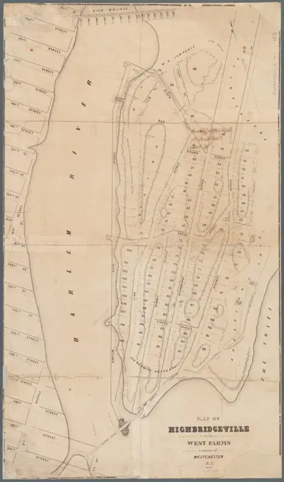
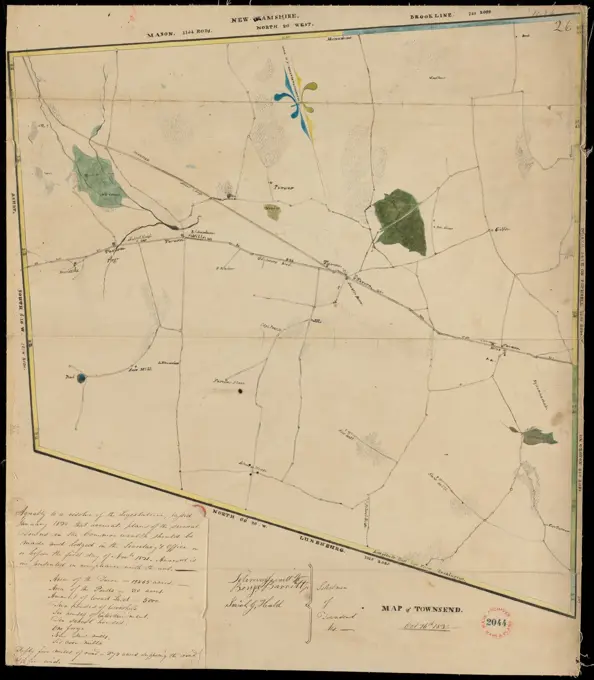
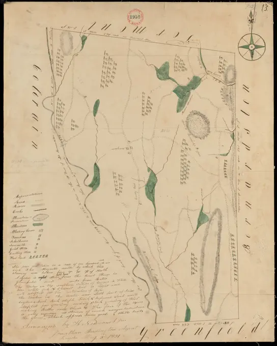
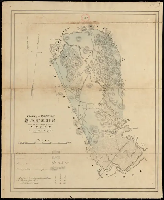
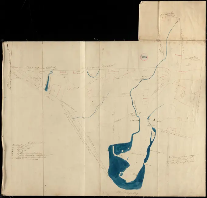
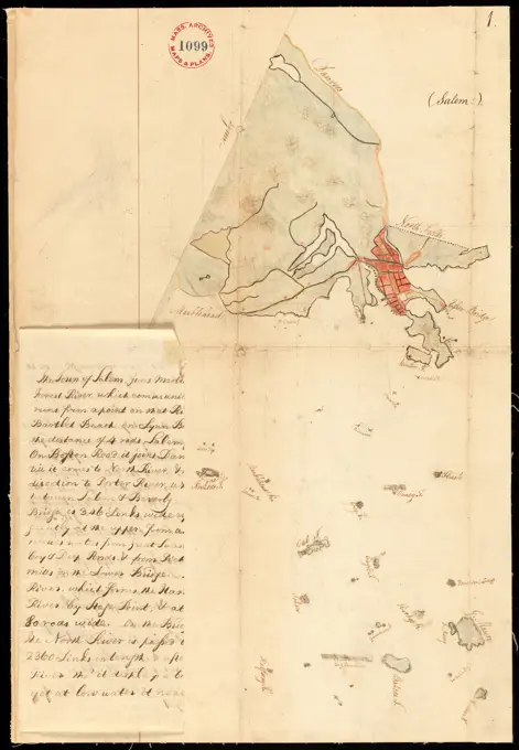
Detailed survey maps from the late 18th century depicting towns like Ashburnham and Milford, showcasing historic land demarcations.

Plan of Southampton surveyed by Daniel Barrett, dated December, 1794. ,. Massachusetts. Office of the Secretary of State
Plan of Milford made by Newell Nelson, dated 1831 ,. Massachusetts. Office of the Secretary of StatePlan of Ashby, surveyor's name not given, dated 1830 ,. Massachusetts. Office of the Secretary of StateMap of the town of Dedham taken in the year 1795 by order of the General Court at their session June 18 1794 , Dedham Mass., Maps Norman B. Leventhal Map Center CollectionMap of the town of Dedham taken in the year 1795 by order of the General Court at their session June 18 1794. Manuscript copy of the 1795 manuscript town plan of Dedham by Eliphalet Pond, held by the Massachusetts State Archives. Oriented with north to the bottom. Includes text. Cartographer often listed as Elijah Pond.... , Massachusetts  , Norfolk  ,county   , DedhamTremont St. subway Boston, Mass. Haymarket Sq. Station. Part of a collection of materials intended to provide prospective developers with information about the Government Center urban renewal project and parcel 7 in downtown Boston. Shows tracks, fencing, booths, rooms and other features. Oriented with north to the upper left. "Plan no. 37432."... , Massachusetts  , Suffolk  ,county   , Boston Government CenterStiehl Otto (1860-1940): Sketch and photo album 6: Münster St. Theobald, ThannComputations of Staten Island, 1780 - 1810Schmitz Bruno (1858-1916), Groß-Berlin 1910 competition. Potsdamer Platz. Anhalt train station. (From: Competition Groß-Berlin 1910. The award-winning designs with explanatory report (1911-1911): Development plan. Pressure on paper, 32.5 x 48.4 cm (including scan edges)Jansen Hermann (1869-1945), Planning for Plowdiw (January 22, 1944): General development plan, part N (4E) 1: 5000. Tusche over a break on transparent, 45.8 x 35.8 cm (including scan edges) Jansen Hermann  (1869-1945): Planung für PlowdiwPlan of Milford made by Newell Nelson, dated 1831 ,. Massachusetts. Office of the Secretary of StateMap of Highbridgeville in the town of West Farms: county of Westchester, N.Y. Cartographic. Maps, Cadastral maps. 1870. Lionel Pincus and Princess Firyal Map Division. Real property , New York (State) , Bronx County, Highbridgeville (New York, N.Y.), West Farms (New York, N.Y.)Plan of Reading, Mass. : showing roads, bodies of water, woodlands, homes, churches, schools, post offices, and taverns. Map depicts the town of Reading, including the area now covering North Reading, showing roads, bodies of water, woodlands, homes, churches, schools, post offices, and taverns. "The reputed distance to Boston Market 12 miles, to E. Cambridge 11 miles, to Concord 16 miles. There are 4 Houses of Public Worship, 2 Grist Mills, 3 Saw Mills, 2 Private Academies, 7 School Houses. No. of inhabitants in 1830 - 1806. From actual survey by Edmund Parker. Published Feb'y 1831."-- Text from map.... , Massachusetts  , Middlesex  ,county   , Reading Massachusetts  , Middlesex  ,county   , North ReadingPlan of Biddeford, made by Partridge Richardson, dated 1794. ,. Massachusetts. Office of the Secretary of StatePlan of Weymouth surveyed by James Humphreys, dated May 27, 1795. ,. Massachusetts. Office of the Secretary of StateNiagara 1819 , Canada, Boundaries, United States, Maps, Niagara River N.Y. and Ont., Maps, United States, Boundaries, Canada, Maps, United States, History, War of 1812, Territorial questions, Maps Norman B. Leventhal Map Center CollectionSurvey of part of the Grange of Portmarnock Survey of part of the Grange of Portmarnock in the barony of Coolock 1789. Cartographic. Maps. Manuscripts and Archives Division. Portmarnock (Ireland)Plan of Townsend, surveyor's name not given, dated October 26, 1831 ,. Massachusetts. Office of the Secretary of StatePlan of Reading and Lynnfield, made by Daniel Needham, dated November 1794. Scale 200 rds to 1 in..... , Massachusetts  , Essex  ,county   , LynnfieldPlan of Lowell made by John G. Hales, dated 1831.... , Massachusetts  , Middlesex  ,county   , LowellPlan of Harrington (Plantation No.5) west of Machias, made by William Tupper, dated December 29, 1795. ,. Massachusetts. Office of the Secretary of StatePlan of Natick surveyed by Isaac Coolidge, dated February, 1795..... , Massachusetts  , Middlesex  ,county   , NatickPlan of Township No.2 (Freeman) and Township No.3 (New Portland) surveyed by Samuel Freeman, dated 1795. ,. Massachusetts. Office of the Secretary of StateKarte der südlichen provinzen der Argentinischen Republik, zu seiner reise durch die La Plata-Staaten entworfen von Dr. Herm. Burmeister , Argentina, Maps Norman B. Leventhal Map Center CollectionExisting parking with 2 and 2 parking between Mount Pleasant St. & Beach Street, Rockport, Mass. ,Bermudas , Nautical charts, Bermuda Islands, Early works to 1800, Bermuda Islands, Maps, Early works to 1800 Norman B. Leventhal Map Center CollectionThe map covers an area from St Helena Bay in the west to the mouth of the Great Fish River in the east, bordered to the north by the line Great Mountain Range - Piketberg - Bokkeveld - Kleine Roggeveld - Nieuweveldsbergen - Camdebo - Snow Mountains - Great Fish River, accessed by a guide map, with coordinates of longitude and latitude, Map of the Southern part of the Cape from St Helena Bay to the Great Fish River., draughtsman: Robert Jacob Gordon, (attributed to), Johannes Schumacher, (possibly), Kaapprovincie, c. 1777 - 1786, paper, pen, brush, h 770 mm × w 1490 mmPlan of Leyden made by H. Newcomb Jr, dated May 3, 1831 ,. Massachusetts. Office of the Secretary of StateMap of the lands west of the Kostverlorvaart in Amsterdam, Anonymous, 1767 print  Amsterdam paper etching maps of separate countries or regions Dietary LorgeonGammelbo Mill. Map of Svansbo 1652.Kartor, drawings and share letters regarding utility and mining companies.UR Carl Sahlin's mountain history collection.Plan of Saugus made by John G. Hales, dated 1831 ,. Massachusetts. Office of the Secretary of StateMap of proposed arboretum, showing its outlines and local connections, with a study for public drive passing through it. Oriented with north toward the upper right. "Fredk. Law Olmsted, landscape architect."... , Massachusetts  , Suffolk  ,county   , Boston  , Jamaica Plain Arnold ArboretumArmy camps of the Dutch and French armies at Leuven, ca. 1705; Plan of the Hollandsch and Fransche Armee Soo if the Selve nowadays are camped by Leuve for the Diele Rievier. Map of the Hoogkampen van de Hollandse and the French armies on the Dijle River at Leuven, approx. 1705. At the bottom right The legend A-H in Dutch. Part of a collection of signed plans of enhanced places in the Netherlands and surrounding countries at the time of the Spanish Succession War (Part D).Kaart van Den Helder en een deel van Texel met het tussenliggende Marsdiep. Afbeeldinge vanden Helder de wijtte van het marsdiep ende een gedeelte van Texel door Ysaek Haringhuijsen, Ariaen van Twuijver & Abraham Bluzé, in april & maij 1688 (title on object). Artist: Isaac Haringhuysen (mentioned on object). Artist: Adriaen van Twuijver (mentioned on object). Artist: Abram Bleuse (mentioned on object). Draughtsman: anonymous. Dating: in or after 1688. Measurements: h 314 mm × w 410 mm. Museum: Rijksmuseum, Amsterdam.Niagara 1819 , Canada, Boundaries, United States, Maps, Niagara River N.Y. and Ont., Maps, United States, Boundaries, Canada, Maps, United States, History, War of 1812, Territorial questions, Maps Norman B. Leventhal Map Center CollectionCartographic, Maps. 1868. Lionel Pincus and Princess Firyal Map Division Page 24: Bounded by 199th Street, Harlem River, 177th Street and Hudson River. Sackersdorff Farm set.Plan of Swansey made by William Peck, dated November 1830 ,. Massachusetts. Office of the Secretary of StateQuackenboss and G. Abeel land at Crown Point 1784. Cartographic. Maps, Surveys, land surveys. Manuscripts and Archives DivisionPlan of Bath, Me, made by Dummer Sewall, dated March 7, 1795. ,. Massachusetts. Office of the Secretary of StateMüller Siegmund, seaport. Schinkel competition 1898 (April 23, 1898): Depending plan 1: 25000. Ink, ink colored watercolor on the box, 41.5 x 34.3 cm (including scan edges) Müller Siegmund : Seehafen. Schinkelwettbewerb 1898Tidal currents of Long Island Sound and approaches Cartographic. Maps. 1854. Lionel Pincus and Princess Firyal Map Division. Tidal currents , Long Island Sound (N.Y. and Conn.), Long Island (N.Y.), Long Island Sound (N.Y. and Conn.), Atlantic Ocean , Long Island Sound (N.Y. and Conn.)Plan of Rowley surveyed by Joseph Chapin, dated December, 1794. ,. Massachusetts. Office of the Secretary of StatePlan of Leicester, surveyor's name not given, dated 1831 ,. Massachusetts. Office of the Secretary of StatePlan of New Ashford surveyed by John Burchett, dated June 5, 1795. ,. Massachusetts. Office of the Secretary of StatePlan of Sturbridge surveyed by Job Hamant, dated May 6, 1795..... , Massachusetts  , Worcester  ,county   , SturbridgeCastel d'Orgeval, Parc de Beausejour, Propriété de M Laurent (Garden Plan, Castle d'Orgeval, Property of Mr. Laurent). Date/Period: 1905. Drawing. Graphite, red pencil on tracing paper, ruled lines in graphite. Author: HECTOR GUIMARD.Plan of Plainfield made by E. S. Darling, dated November, 1830 ,. Massachusetts. Office of the Secretary of StateOhio boundary no. 2 : map exhibiting the positions occupied on the Maumee Bay and river: viz: Turtle Island, the North Cape, and that above Toledo, together with the position of the 'east line,' in its passage of the Maumee River surveyed under the direction of Capt. Talcott, U.S. Engineers, by Lieuts. Hood & R.E. Lee , Lucas County Ohio, Maps, Maumee River Ind. and Ohio, Maps, Erie, Lake, Maps, Toledo Ohio, Maps, Michigan, Boundaries, Ohio, Maps, Ohio, Boundaries, Michigan, Maps Norman B. Leventhal Map Center CollectionPlan of Wrentham surveyed by Cornelius Kollock, dated January 1795..... , Massachusetts  , Norfolk  ,county   , WrenthamPlan of Dorchester made by Mather Withington, dated September, 1794..... , Canada  , Province of British Columbia  ,province   , Kersleyunknown artist, A Collection of Surveys of Scottish Estates of the Earl of Selkirk: Little Sypeland, undated. Graphite, watercolor, gray wash, pen and blue and black ink on slightly textured, moderately thick, cream wove paper.Plan of Weston surveyed by Jonathan Kingsbury, dated 1794-5. ,. Massachusetts. Office of the Secretary of StateCartographic, Maps. 1912. Lionel Pincus and Princess Firyal Map Division. Fire insurance , New York (State), Real property , New York (State), Cities & towns , New York (State) Manhattan V. 7, Plate No. 107 Map of Central Park bounded by Transverse Road No. 4, 5th Ave., E. 84th St., Central Park West.N.N., North American hydraulic engineering. (From: Atlas to the magazine for Building, ed. V. Ministry of Public Works, Jg. 45, 1895, supplementary book): Water supply New York, St. Louis, tunnel Chicago. Stitch on paper, 43 x 56.2 cm (including scan edges)Map of the county of Orleans Cartographic. Atlases, Maps. 1841. Lionel Pincus and Princess Firyal Map Division. New York (N.Y.), Real property , New York Metropolitan Area, Orleans County (N.Y.) , Maps, Real property , New York (State) , Orleans CountyPlan of Medford made by John Sparrell, dated 1830 ,. Massachusetts. Office of the Secretary of StateStiehl Otto (1860-1940): Sketch and photo album 18: St. Alexius, PaderbornBottom right the title with above it a Scale of 900 Rhineland rods, Map of Oost-Vlieland and West-Terschelling Caarte van Oostvlielant, with wester Schelling, and a sea-hole in between. Measured and castrated by Isaac Haringhuijsen, Adriaan van Twuijver, and Abram Bluze in April 1688., draughtsman: anonymous, Isaac Haringhuysen, (mentioned on object), Adriaen van Twuijver, (mentioned on object), in or after 1688, paper, brush, pen, h 409 mm × w 316 mmA map of part of the land in the Royal Grant devised by Sir William Johnson to some of his natural Indian children Documentary history of the State of New-York Cartographic. Maps. 1859. Lionel Pincus and Princess Firyal Map Division. Johnson, William, 1715-1774 , Homes and haunts, Land grants , New York (State) , Salisbury, Landowners , New York (State) , Salisbury, Real property , New York (State) , Salisbury, Salisbury (N.Y.), Herkimer County (N.Y.)Map with the positions of the armies during the Battle of Fleurus, June 1794, Anonymous, Hilmar Johannes Backer, 1834 - 1835 print Map with the positions of the Allied and French armies during the Battle of Fleurus, 26 June 1794. French victory over the Austrians. Marked at the top: milit. Spectr. Iiide part / pl: ii. Dordrecht paper  maps of separate countries or regions. battle arrays FlowerCartographic, Maps. 1942. Lionel Pincus and Princess Firyal Map Division. Real property , New York (State) , New York (N.Y.), Bronx (New York, N.Y.) , Maps Block Index. Volume OneRun -up to Texel, 1581 - 1638 print The island of Texel at the top right; Below Holland.  paper engravingRemarques sur la navigation de terre-neuve à New-York afin d'eviter les courrants et les bas-fonds au sud de Nantuckett et du Banc de George , Gulf Stream, Maps Norman B. Leventhal Map Center CollectionMap of Montague Village. Relief shown by hachures.... , Massachusetts  , Franklin  ,county   , MontagueMap of Schieland, Anonymous, After Floris Balthasarsz. van Berckenrode, after Balthasar Florisz. Van Berckenrode, 1800 - 1900 drawing Map of Schieland, signed to the thirteen -part map 'Caert van Schielandt' by Landmeters Floris Balthasarsz. and Balthasar Florisz. van Berckenrode.  paper. ink. pencil pen / brush maps of separate countries or regions SchielandJansen Hermann (1869-1945), total development plan Ankara (1930): basic plan 1: 2000, partial sheet 5a. Tusche, colored pencil over a break on transparent, 91.5 x 103.6 cm (including scan edges) Jansen Hermann  (1869-1945): Gesamtbebauungsplan AnkaraPlan of Kingston surveyed by John Gray, dated May 6, 1795..... , Massachusetts  , Middlesex  ,county   , KingstonPlan of Woburn made by Bartholomew Richardson, dated 1831.... , Massachusetts  , Middlesex  ,county   , WoburnKlomp Johannes Franziskus (1865-1946), St. Antonius of Padua, Rheine (November 13, 1901): Details of the base (1: 1). Pencil, colored pencil on transparent, 88.8 x 98.3 cm (including scan edges) Klomp Johannes Franziskus  (1865-1946): St. Antonius von Padua, RheineAtherton, St. Lawrence County, New York, township no. 3, great lot no. 2, Macomn's purchase: survey commenced in 1853 by J.E. Potter, & completed in the winter of 1857-8 by Edwin A. Merritt Cartographic. Maps, Cadastral maps. 1858. Lionel Pincus and Princess Firyal Map Division. Landowners , New York (State) , Saint Lawrence County, Real property , New York (State) , Saint Lawrence County, Piercefield (N.Y.), Saint Lawrence County (N.Y.)Delft, Berckenrode, Balthasar Florisz. van, Floris Balthasarsz. van, True image of Delflandt, Map of Delfland (sheet top right), verso - stamped, Map of Delfland. Top center the coat of arms of the Hoogheemraadschap Delfland and the municipal coats of arms of the cities. Bottom left a wind rose. Consisting of nine sheets and six text sheets: sheet top right., print, map, prints, height 250 mm, width 260 mm, 1562 - 1616-12-10, print maker, printmaker, 1612 - 1612, first quarter 17th century, paper, engraving, engraving (printing process), etching, Northern Netherlands, 1592 - 1645Large copper mountain chronology. Mining maps.ur Carl Sahlin's mountain historical collection.A Collection of Surveys of Scottish Estates of the Earl of Selkirk: Little Kirkland, unknown artist, undated, Graphite, watercolor, gray wash, pen and black ink on slightly textured, moderately thick, cream wove paper, Sheet: 19 3/4 × 13 11/16 inches (50.2 × 34.8 cm), architectural subjectPlan of No Man's Land (Chilmark), surveyor's name not given, dated 1830.... , Massachusetts  , Dukes  ,county   , Martha's Vineyard  ,island   , ChilmarkPlan of Salem, surveyor's name not given, dated 1794. ,. Massachusetts. Office of the Secretary of StatePlan of Dorchester made by Mather Withington, dated September, 1794. ,. Massachusetts. Office of the Secretary of StateStiehl Otto (1860-1940): Sketch and photo album 5: San Benedetto in Polirono, San Benedetto PoN.N., Garden of the Nanzenin Temple, Kyoto (without dat.): Floor plan 1: 150. Pressure on paper, 75.6 x 89.7 cm (including scan edges) N.N. : Garten des Nanzenin-Tempels, KyotoPlan of Prescott made by E. S. Darling, dated October, 1830.... , Massachusetts  , Franklin  ,county   , Prescott  ,areaStiehl Otto (1860-1940): Sketch and photo album 1: Dom, DoberanCommunications entre l'Angleterre, l'Allemagne, et la France, par les chemins de fer Belges , Railroads, Belgium, Maps, Railroads, Europe, Western, Maps, Europe, Western, Maps Norman B. Leventhal Map Center CollectionKlomp Johannes Franziskus (1865-1946), Heart of Jesus Kloster, Cinqfontaines (Fünfbrunnen) near Ulflingen (Troisvierges) / Luxembourg (12.10.1909): Details of the inner profiles of the organ stage and parapets (1: 1). Pencil, colored pencil on transparent, 75.8 x 97.7 cm (including scan edges)Bosrand met jagerswoning.Leaf 32 Recto from a sketchbook with 69 sheets.Dorothy M Gerhard, Cap, c 1940 CapMap of the Monongahela River from the Virginia line to Pittsburgh , Monongahela River W. Va. and Pa., Maps Norman B. Leventhal Map Center CollectionTrustees' sale : beautiful building lots on Walnut St. and Walnut Avenue, in West Roxbury, containing about 3,126,519 square feet , Real property, Massachusetts, Boston, Maps, Land tenure, Massachusetts, Boston, Maps, West Roxbury Boston, Mass., Maps, West Roxbury Boston, Mass. Norman B. Leventhal Map Center CollectionForty plan of Fort Victoria on Ambon, 1718 drawing A bowl with a scale of 30 Rijnlandse rods on the right, with a compass rose underneath.  paper. watercolor (paint). ink pen / brush fortress AmbonPlan of Lovejoy's narrows from a survey of the Kennebeck River, dated 1826. The map measures 55 x 50 cm, mounted on a sheet of 60 x 53 cm. It is attributed to Washington, D.C., and the publisher is not identified. The map pertains to the Kennebec River and the Kennebec River Valley in MaineA plan of a survey of Noddles Island , East Boston Boston, Mass., Maps Norman B. Leventhal Map Center CollectionA geological and topographical rough survey map of the Hinckley Coal Lands near Warsaw, Coshocton County, Ohio, 1883. Additional, Hinckley Coal Lands near Warsaw, Coshocton County, Ohio., 1883., Northampton, Mass. Publisher, Benjamin Smith Lyman, 1 map; 27 x 27 cm, on sheet 37 x 33 cm