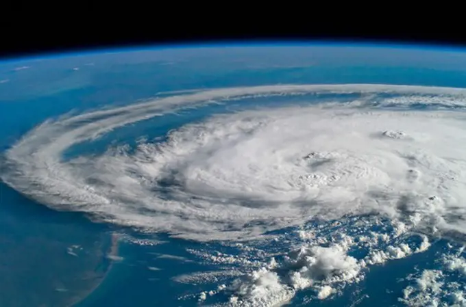
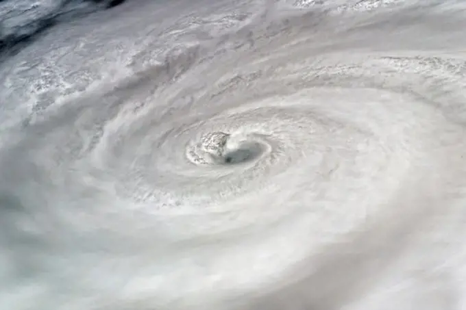
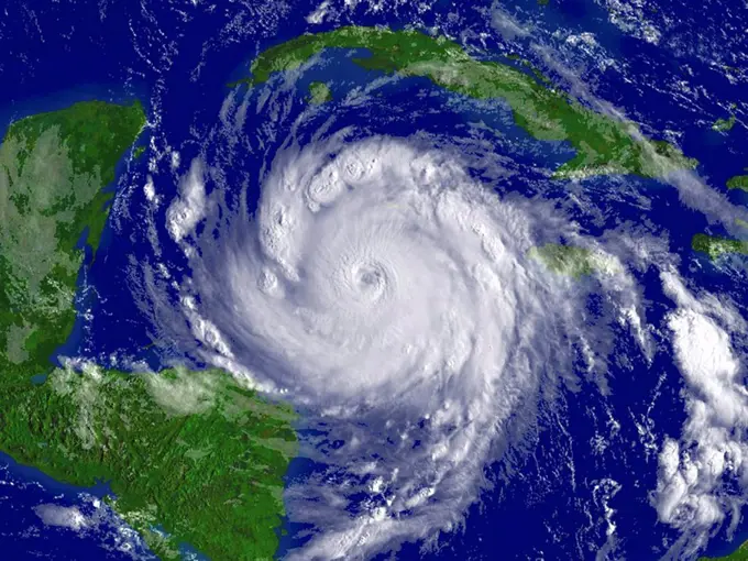
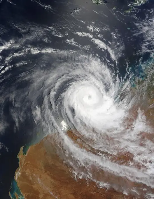
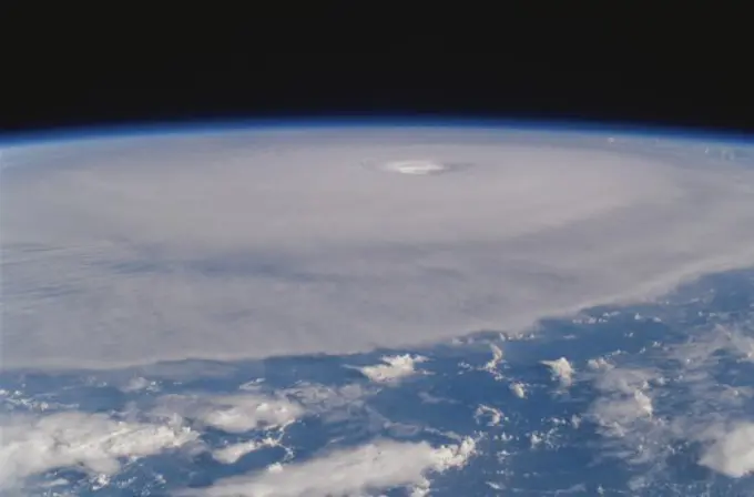
My Boards
View Pictures
  • My Boards

Hurricane Impact Imagery

Satellite images showcasing hurricanes over the ocean, illustrating the immense power of nature and its effects on the environment.

Hurricane Claudette
Hurricane Claudette
143 assets in this story
4389-479
Hurricane Dean
6145-44555513
STS085-722-019 (15 August 1997) --- This view of supertyphoon Winnie was taken on August 15, 1997, as the storm swirled about 400 miles south of the southern tip of Japan.  Sustained winds were 105 knots, gusting to 130 knots.  This photo was shot on the Space Shuttle Discovery's twenty-third flight, as it glided by 170 miles above the sea surface on Orbit 123.  On one pass the Discovery flew right over the eye; the commander commented that the eye was so large that it completely filled the window.  The robotic arm crosses the top of the view.  The cloud mass associated with Winnie covered thousands of square miles as this storm grew to supertyphoon status in the previous days, and raked across the Marianas Islands.  A few days after this shot was taken, Winnie ploughed ashore on the coast of China, a bit south of the major metropolis of Shanghai, reportedly killing at least 100 people.
1525-25770188
India city lights and tornado. 3d rendering. India city lights and tornado. Elements of this image furnished by NASA. 3d rendering. India city lights and tornado. 3d rendering
4128R-5662
Hurricane Dean, 20 August 2007
1457R-1247A
Tropical Cyclone Billy over Australia
6145-44914036
ISS033-E-016695 (29 Oct. 2012) --- One of the Expedition 33 crew members aboard the International Space Station took this photo of Hurricane Sandy at 16:55:32 GMT on Oct. 29, 2012.  East is generally at the top of the photo, south to the right.  At the camera time of the photo Sandy was located by the National Hurricane Center at approximately 37.5 degrees north latitude and 71.5 degrees west longitude or 25 miles southeast of Atlantic City, New Jersey moving north-northwest at 18 miles per hour and packing winds of 90 miles per hour.
1746-21119065
Photograph of Hurricane David making landfall on the Georgia Coast. Dated 1979
1457-1095
Remnants of Tropical Storm Bertha dumped heavy rains across parts of Louisiana and Mississippi on August 5, 2002
6145-45257625
In early June, 2015 a strong low pressure system over the North Atlantic Ocean brought rain and gusty winds to Ireland and the United Kingdom. The Moderate Resolution Imaging Spectroradiometer (MODIS) aboard NASAs Aqua satellite captured this true-color image of the spiraling system on June 5. A very deep low pressure area lies in the center of the spiral, just off the northwestern shore of emerald-green Ireland. Bands of cloud, containing rain and thunderstorms, swirl into the center of the low, and extend over the British Isles. A low pressure system will pull in air from the surrounding area, creating spiraling winds. Winds around the center of a low pressure spiral counterclockwise in the Northern Hemisphere, as we see here (clockwise in the Southern Hemisphere) and towards the center of the system. Although the system was impressive on June 5, it intensified over the next several days. According to MarkVoganWeather.com, by June 7 the pressure in the unusually deep Atlantic low, w
6145-44770173
This thunderstorm along the Texas Gulf Coast (29.0N, 95.0W), USA is seen as the trailing edge of a large cloud mass formed along the leading edge of a spring frontal system stretching northwest to southeast across the Texas Gulf Coast. This system brought extensive severe weather and flooding to parts of Texas and surrounding states. Muddy water discharging from coastal streams can be seen in the shallow Gulf of Mexico as far south as Lavaca Bay.
6145-45258391
NASA Gets a Last Look at Post-Tropical Cyclone Matthew Before It was Swallowed Up Post-Tropical Cyclone Matthew was swallowed up or absorbed by a cold front on Oct. 10, but NASA's Terra satellite captured a last look at the storm before that happened. On Sunday, Oct. 9, 2016 at 11 45 a.m. EDT (1545 UTC) NASA's Terra satellite captured a last look at Post-Tropical Cyclone Matthew as it was being absorbed by a cold front along the U.S. Eastern Seaboard.
6145-45260440
Tropical Storm Hagupit's low level circulation center is being obscured by its deep central convection and intensities are hard to pinpoint as the storm interacts with land. Once clear over the waters of the South China Sea Hagupit is forecast to continue weakening as it approaches the southern coast of Vietnam. This image was taken by the Suomi NPP satellite's VIIRS instrument around 0510Z on December 8, 2014. NASA/NOAA/NPP
6145-44372559
ATLANTIC OCEAN (Sept. 5, 2017) A GOES satellite image showing Hurricane Irma in the Atlantic Ocean. The storm is a category 4 hurricane on the Saffir-Simpson hurricane wind scale. Maximum sustained winds have increased to near 150 mph (240 km/h) with higher gusts. Some fluctuations in intensity are likely during the next day or two, but Irma is forecast to remain a powerful category 4 hurricane. Hurricane-force winds extend outward up to 45 miles (75 km) from the center and tropical-storm-force winds extend outward up to 140 miles (220 km). The estimated minimum central pressure is 937 mb (27.67 inches).
6145-44684576
S118-E-07920 (18 Aug. 2007) --- Crewmembers on the Space Shuttle Endeavour captured this image around Noon CDT of Hurricane Dean in the Caribbean.  At the time the shuttle and International Space Station passed overhead, the Category 4 storm was moving westerly at 17 mph nearing Jamaica carrying sustained winds of 150 mph.
1574R-015333
Hurricane Isabel
6145-45084887
GMT360_00_01_Terry Virts_australia indonesia_129
6145-45232130
Clouds associated with the major winter storm that is bringing wintry precipitation and chilly temperatures to the U.S. south is the focus in an image from NOAA's GOES-East satellite today, February 12 at 1310 UTC/ 8 10 EST. Rain, freezing rain, sleet and snow are part of the large front that stretches from eastern Texas to the Carolinas in the Geostationary Operational Environmental satellite or GOES image. NOAA's weather maps show several areas of low pressure along the frontal boundary. One low pressure is in the northern Gulf of Mexico, while the other is in the Atlantic Ocean, just south of South Carolina. (Insert link a href= http //www.hpc.ncep.noaa.gov/noaa/noaad1.gif rel= nofollow www.hpc.ncep.noaa.gov/noaa/noaad1.gif /a ). NOAA's National Weather Service has been issuing watches and warnings throughout the south that extend along Mid-Atlantic east coast. The visible cloud and ground snow data in this image was taken from NOAA's GOES-East satellite. The image was created by th
6145-45232140
. Heat Wave Building Into the Ohio Valley and Eastern United States
6145-45084886
GMT360_00_01_Terry Virts_australia indonesia_129
6145-45257152
. Further Storm Approaches Western Europe
6145-44879733
ISS028-E-045516 (9 Sept. 2011) --- Hurricane Katia off the northeastern USA coastline is featured in this image photographed by an Expedition 28 crew member on the International Space Station. Hurricane Katia had diminished to Category 1 strength on the Saffir-Simpson scale at the time this photograph was taken, but it still presented an impressive cloud circulation as its center passed by the northeastern USA coastline on Sept. 9, 2011. The storm had reached Category 4 strength earlier on Sept. 5, making it the second major hurricane of the 2011 Atlantic hurricane season. Katia remained over open waters of the Atlantic Ocean during its lifetime, unlike two preceding storms of the season  Hurricane Irene and Tropical Storm Lee  both of which made landfall on the continental USA. The approximate center of Hurricane Katia is visible at lower right, with its outer cloud bands extending across the center of the view. A small part of the State of New York  including Long Island and the H
6145-45232144
NOAA's GOES-15 satellite captured the southern California "June Gloom" on June 10, 2013. That's a weather pattern that creates cloudy, overcast skies and cool temperatures. The "June Gloom" of low lying stratus clouds form over the ocean and can be pushed to coastal areas by wind. It usually happens off the west coast of California during the late spring and early summer. As for the "seam" of blue within the "June Gloom," it appears to be actinoform clouds, a seam in the marine stratocumulus aka "June Gloom" of southern California. Actinoform clouds and marine stratus in general are only marginally stable. Sometimes the cloud deck spontaneously dissolves along a line by drizzling out the moisture. This seam is an unusually long curve that is not identified with a coastline or a weather front. Dennis Chesters/Rob Gutro NASA's Goddard Space Flight Center, Greenbelt, Md. REFERENCES a href= http //en.wikipedia.org/wiki/Actinoform_cloud rel=
6145-44637289
ISS012-E-5256 (19 Oct. 2005) --- This image of Hurricane Wilma was taken at 8:23 a.m. CDT Wednesday, Oct. 19, by the crew aboard NASA's international space station as the complex flew 222 miles above the storm. At the time, Wilma was the strongest Atlantic hurricane in history, with winds near 175 miles per hour. The storm was located in the Caribbean Sea, 340 miles southeast of Cozumel, Mexico.
6145-45083102
GMT340_20_14_Terry Virts_Typhoon Hagiput_123
6145-45257416
. Major Nor'easter Set to Impact Northeast U.S.
6145-44973418
This image, acquired by NASA's Terra spacecraft, shows the Rim Fire in and around Yosemite National Park in California after it was 80 percent contained.
6145-45256645
. Satellite Shows Difficult Eastern U.S. Thanksgiving Travel
6145-45258406
The smoke from the Canadian wildfires that was in the middle of the U.S. on June 30 has drifted its way to the East Coast obscuring parts of the coast from New Jersey to North Carolina. Images taken on June 30 showed the smoke covering states from Minnesota to Tennessee. The jet stream has pushed the smoke along so that by July 1 it reached the U.S. East Coast. Residents of the area will get a preview of July 4th fireworks with redder than usual sunrises and sunsets due to particulates in the air. This natural-color satellite image was collected by the Moderate Resolution Imaging Spectroradiometer (MODIS) aboard the Aqua satellite on July 1, 2015.
6145-52074104
Hurricane Wilma - Command Center Files - 26-HK-439-8. 25 Oct 2005 WILMA. Hurricane Katrina
7193-70585443
USA, Florida, Miami, Hurricane Research.
6145-45086987
The U.S. National Weather Service called it a a crippling and historic winter blizzard.” In late January 2015, transportation systems from Trenton to Portland were shut down, and more than 35 million people hunkered down for extreme snowfall and biting winds. For those in New England, it turned out to be a monstrous storm. For the Mid-Atlantic region, not so much. Vast swaths of Massachusetts, Connecticut, Rhode Island, New Hampshire, Maine, and Long Island (NY) were blanketed with 15 to 25 inches (40 to 60 centimeters) of snow as of midday on January 27, 2015, and snow was expected to continue into January 28. Sustained winds reached gale force, with hurricane-force gusts along the coastlines. Storm surges sent ice and water into the streets of Scituate and Nantucket, Massachusetts. Many New England towns, including the city of Boston, were expected to approach all-time snowfall records. The Visible Infrared Imaging Radiometer Suite on the Suomi NPP satellite acquired these nighttime
6145-45232139
. Rim Fire Expands into Yosemite National Park
6145-51991615
Image created to provide a visual representation to commemorate the second anniversary of Hurricane Sandy... Photographs Relating to Disasters and Emergency Management Programs, Activities, and Officials
6145-54630349
Department of the Interior senior officials, including U.S. Geological Survey (USGS) Acting Director P. Patrick Leahy, at USGS-sponsored presentation on Hurricane Katrina
7193-70585441
USA, Florida, Miami, Hurricane Research.
6145-45052077
Though North America is a full month into astronomical spring, the Great Lakes have been slow to give up on winter. As of April 22, 2014, the Great Lakes were 33.9 percent ice covered. The lake they call Superior dominated the pack. In the early afternoon on April 20, 2014, the Moderate Resolution Imaging Spectroradiometer (MODIS) on NASAs Aqua satellite captured this natural-color image of Lake Superior, which straddles the United States-Canada border. At the time Aqua passed over, the lake was 63.5 percent ice covered, according to the NOAA Great Lakes Environmental Research Lab (GLERL). Averaged across Lake Superior, ice was 22.6 centimeters (8.9 inches) thick; it was as much as twice that thickness in some locations. GLERL researcher George Leshkevich affirmed that ice cover this spring is significantly above normal. For comparison, Lake Superior had 3.6 percent ice cover on April 20, 2013; in 2012, ice was completely gone by April 12. In the last winter that ice cover grew so thi
6145-50568350
2005 significant U.S. hurricane strikes , Hurricanes, United States, Maps, United States, Maps Norman B. Leventhal Map Center Collection
6145-51993313
Washington, DC, September 5, 2008   This is the latest map FEMA has produced on Hurricane Ike. FEMA mapping produces maps for workers in the National Response and Coordination Center in Washington, DC. FEMA.. Photographs Relating to Disasters and Emergency Management Programs, Activities, and Officials
6145-45133947
2017 NASA Earth Day at Union Station, Washington DC. Mr. Ernie Wright.
6145-44636114
In September, 2005, Rita was a category 5 hurricane with sustained winds of 150 mph and a central pressure of 897 millibar when positioned approximately 470 southeast of Galveston, Texas.
6145-44636666
Distribution Patterns of LandSurface Water from Hurricanes Katrina and Rita
6145-51991660
Meteorólogo John Morales de NBC 6, empresario y reconocido icono del estado del tiempo en la comunidad hispana... Photographs Relating to Disasters and Emergency Management Programs, Activities, and Officials
6145-44604895
A Mostly Quiet Pacific
PREVIOUS
of 2
NEXT
2401 S. Ervay, Suite 206
Dallas, Texas 75215
United States
Get Started
Free ResearchMy BoardsMy Cart
For Creators
How To License Your ContentContributor PortalFrame of Mind
Resources
API accessPricing
Contact
+1 866 236 0087help@viewpictures.co.uk Contact form
©2026 View Pictures. All Rights Reserved. -A
This site is protected by reCAPTCHA and Google Privacy Policy and Terms of Service apply.