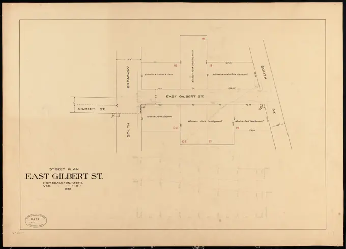
My Boards
View Pictures
  • My Boards

Lawrence Street Plans

Architectural plans and profiles of various streets in Lawrence, illustrating urban development and layout in detail.

Street plan, East Gilbert St. , Streets. Lawrence
286 assets in this story
6145-48696915
Plan and profile of Lansdowne Ct. , Streets. Lawrence
6145-48559130
Plan of an estate in High St. to be sold at auction Sat. May 1st 1847 at 12 o'clock on the premises by Whitwell, Seaver & Co. auctioneers , Real property, Massachusetts, Boston, Maps, Land tenure, Massachusetts, Boston, Maps Norman B. Leventhal Map Center Collection
6145-50573758
Plan and profile of Alma St. , Streets. Lawrence
6145-48697174
Keighley Ct. , Streets. Lawrence
6145-48435601
Lucae Richard (1829-1877), commercial academy in Berlin. 2nd project (1876): site plan. Ink, ink colored, watercolor on paper, 74.7 x 81.9 cm (including scan edges)
6145-54268697
Plan of lands in West-Roxbury, belonging to the estate of Chas. M. Taft : to be sold by public auction on Wednesday June 9th 1858 at 3 1/2 o'clock p.m. Oriented with north toward the lower left.... , Massachusetts  , Suffolk  ,county   , Boston  , West Roxbury
6145-54521842
Cartographic, Maps. 1889. Lionel Pincus and Princess Firyal Map Division. Real property , New York (State) , New York, New York (N.Y.) Plate 14 Map bounded by W. 114th St., 8th Ave., W. 110th St., 10th Ave.
6145-52830707
Floor plan of the ground division at Semperdepot in Vienna VI, drawn in pencil on transparent paper by an anonymous architect in March 1927.
6145-48489863
Lender Hermann, Reichsgericht in Leipzig (06.1885): site plan. Tusche, pencil watercolor on cardboard, 46.9 x 59.7 cm (including scan edges)
6145-48444699
Jansen Hermann (1869-1945), construction of a settlement for the non-profit small house construction company in Berlin-Heiligensee (1921-1921): Grund- und Dialtplan 1: 500, overview sketch. Ink and pencil on transparent, 72.7 x 139.9 cm (including scan edges) Jansen Hermann  (1869-1945): Bau einer Siedlung für die gemeinnützige Kleinhausbaugesellschaft, Berlin-Heiligensee
6145-55958022
Lansingburgh, Map bounded by Gould St., Cemetery Ave., Hudson River Cartographic. Atlases, Maps. 1872. Lionel Pincus and Princess Firyal Map Division. Lansingburgh (N.Y.)
6145-54523405
Cartographic, Maps. 1884 - 1936. Lionel Pincus and Princess Firyal Map Division. Fire insurance , New York (State), Real property , New York (State), Cities & towns , New York (State) Brooklyn V. 10, Plate No. 45 Map bounded by Coney Island Ave., Ditmas Ave., Marlborough Rd., Foster Ave.
6145-54523616
Cartographic, Maps. 1884 - 1936. Lionel Pincus and Princess Firyal Map Division. Fire insurance , New York (State), Real property , New York (State), Cities & towns , New York (State) Brooklyn V. 15, Plate No. 107 Map bounded by Avenue T, E.54th St., Flatbush Ave.
6145-42603140
Barth Erwin (1880-1933), Fraenkel garden in Berlin-Kladow (23.02.1933): Survey document of the property, 1: 500. Light break on linen, 73.7 x 33.6 cm (including scan edges) Barth Erwin  (1880-1933): Garten Fraenkel, Berlin-Kladow
6145-48494221
Ende & Böckmann, Museum of Ethnology, Berlin (1880-1886): site plan 1: 250. Lithograph, 80.4 x 66.6 cm (including scan edges)
6145-55928022
Cartographic, Maps. 1884 - 1936. Lionel Pincus and Princess Firyal Map Division. Fire insurance , New York (State), Real property , New York (State), Cities & towns , New York (State) Brooklyn V. 12, Plate No. 98 Map bounded by Bay Parkway, 61st St., 21st Ave.
6145-50550748
Layout plan, Blakemore Ct. , Streets. Lawrence
4409-21522306
Vol. 2. Plate, O. Map bound by Stanhope St., Wyckoff Ave., Greene Ave., St. Nicholas Ave., Magnolia St., Hamburg St.; Including Himrod St., Harman St., Bleecker St., Ralph St., Grove St., Linden St., Myrtle Ave., Knickerbocker Ave., Irving Ave.
6145-48697107
Blakelin St. , Streets. Lawrence
6145-54522857
Cartographic, Maps. 1918. Lionel Pincus and Princess Firyal Map Division. Queens (New York, N.Y.), Real property , New York (State) , New York , Queens (Borough) Queens, Vol. 1A, Double Page Plate No. 16; Part of Ward 4 Jamaica. Map bounded by Springfield Blvd, 117th Ave., Boundry line of City of New York
6145-48643927
Chester , Chester Mass., Maps, Railroads, Massachusetts, Chester, Maps Norman B. Leventhal Map Center Collection
6145-54268955
Plan of the Coffin Estate, corner of Summer and Chauncy Streets : to be sold by public auction on Wednesday April 26th 1856 at 12 o'clock noon on the premises. Oriented with north toward the lower right. "N.A. Thompson, Auctioneer." "Boston, March 21st 1856, Alex Wadsworth surveyor." "Kramer & Co's Lith.".. Plan of building lots on Washington, Waltham & Parker Streets and Harrison Avenue, belonging to the Boston Lying-In Hospital Corporation. Plan of building lots on Washington, Waltham & Parker Streets and Harrison Avenue, belonging to the Boston Lying-In Hospital Corporation, Massachusetts  , Suffolk  ,county   , Boston
6145-55167464
Plan of Hoosac Tunnel Dock and Elevator Company's docks and land in Charlestown, Mass.. Oriented with north to the lower left. Shows piers, elevators, storehouses and other buildings. Includes section of building on pier no. 5. Includes references describing building materials, heights and other features.... , Massachusetts  , Suffolk  ,county   , Boston  , Charlestown
6145-48696768
Plan and profile of Bailey St. , Streets. Lawrence
6145-48696946
Plan and profile of Sheridan St. , Streets. Lawrence
6145-54524508
Cartographic, Maps. 1884 - 1936. Lionel Pincus and Princess Firyal Map Division. Fire insurance , New York (State), Real property , New York (State), Cities & towns , New York (State) Queens V. 5, Plate No. 41 Map bounded by Bayside Ave., 14th St., Mitchell Ave., Murray St.
6145-54523581
Cartographic, Maps. 1884 - 1936. Lionel Pincus and Princess Firyal Map Division. Fire insurance , New York (State), Real property , New York (State), Cities & towns , New York (State) Brooklyn V. 15, Plate No. 71 Map bounded by Gerritsen Ave., Avenue S, Avenue T
6145-29925619
Map of the Nonain Kit district (Transnonain)
6145-54523153
Cartographic, Maps. 1884 - 1936. Lionel Pincus and Princess Firyal Map Division. Fire insurance , New York (State), Real property , New York (State), Cities & towns , New York (State) Brooklyn, V. 7, Double Page Plate No. 185 Map bounded by Hopkinson Ave., Belmont Ave., Howard Ave., St. Marks Ave.
6145-50572413
Plan showing location of buildings at Long Beach and the division line between the City of Gloucester and Town of Rockport ,
6145-48696745
Margin Street , Sewers, Streets. Lawrence
6145-54548143
Jane Street, Eighth Avenue, Troy Street, Fourth Street Cartographic. Cadastral maps, Maps. 1832 - 1837. Lionel Pincus and Princess Firyal Map Division. United States , New York (State) , New York, Landowners , New York (State) , New York, Real property , New York (State) , New York, Real propery auctions , New York (State) , New York, West Village (New York, N.Y.), Manhattan (New York, N.Y.)
6145-48446850
Jansen Hermann (1869-1945), traffic and settlement planning of the expansion of the cities of Neukirchen and Vluyn (1925-1925): Partial development plan Neukirchen: Basic Plan 1: 5000. Pencil on transparent, 25.2 x 22.3 cm (including scan edges) Jansen Hermann  (1869-1945): Verkehrs- und Siedlungsplanung der Erweiterung der Städte Neukirchen und Vluyn
6145-48732656
Plan of the highway at the junction of Railroad AveKing St. : Showing the proposed change of the easterly side of Granite St. , Streets
6145-50530314
Avon Street , Sewers, Streets. Lawrence
6145-50573909
Plan and profile of Lexington St. , Streets. Lawrence
6145-54525686
Cartographic, Maps. 1913. Lionel Pincus and Princess Firyal Map Division. Fire insurance , New York (State), Real property , New York (State), Cities & towns , New York (State) Manhattan, V. 12, Plate No. 63 Map bounded by Cold Spring Rd., Crosby Place
6145-48696880
Plan and profile of Logan St. , Streets. Lawrence
6145-48719960
Plan of City Wharf in Boston, Mass : shewing 14 lots of land on the side of the south dock of said wharf & Commercial St. : to be sold by private sale by Josiah Quincy Jr., Brazers' Building, State St , Wharves, Massachusetts, Boston, Maps, Real property, Massachusetts, Boston, Maps, Landowners, Massachusetts, Boston, Maps, Boston Mass., Maps Norman B. Leventhal Map Center Collection
6145-50529540
Atkinson St. Ex. , Streets. Lawrence
6145-50574053
Plan and profile of sewer in Chester St. , Sewers, Streets. Lawrence
6145-54526345
Cartographic, Maps. 1901. Lionel Pincus and Princess Firyal Map Division. Fire insurance , New York (State), Real property , New York (State), Cities & towns , New York (State) Bronx, V. 14, Plate No. 1 Map bounded by Relmont St., Morris Ave., Teller Ave., E. 170th St., Grand Blvd.
6145-50573849
Plan and profile of Ferry St. for establishment of grade , Streets. Lawrence
6145-54267859
Back Bay study landscape plan. Oriented with north to the upper right.. Landscape plan of Back Bay showing the location of trees, plants, and sites of major proposal which include: A) Pedestrian overpass and overlook, B) Boyston Street promenade, C) Commonwealth Avenue mall, D) Dartmouth Street mall, E) Plaza, F) Replace existing steps with pedestrian ramps, and G) Pedestrian passthrough and overpass of Huntington Avenue... , Massachusetts  , Suffolk  ,county   , Boston  , Back Bay
6145-48696917
Plan and profile of Lincoln Ct. , Streets. Lawrence
6145-48476966
Böhmer Franz (1907-1943), Haus Herz in Berlin-Zehlendorf. Conversion to Haus Himmler (June 1st, 1937): Department 1: 250. Light break on paper, 79.6 x 84.9 cm (including scan edges) Böhmer & Petrich : Haus Herz, Berlin-Dahlem. Umbau zu Haus Himmler
6145-48477093
Poelzig Hans (1869-1936), vocational school on Urban, Berlin-Kreuzberg (03.1929): floor plan 1st floor 1: 100. Light break on transparent, 149.2 x 193 cm (including scan edges)
6145-50554113
McFarlin Court , Sewers, Streets. Lawrence
6145-54523778
Cartographic, Maps. 1884 - 1936. Lionel Pincus and Princess Firyal Map Division. Fire insurance , New York (State), Real property , New York (State), Cities & towns , New York (State) Brooklyn, V. 9, Double Page Plate No. 247 Map bounded by Randolph St., Varick Ave., Meadow St., Seneca Ave.
6145-48697123
Daisy Street , Streets. Lawrence
6145-54522612
Cartographic, Maps. 1855. Lionel Pincus and Princess Firyal Map Division. Docks , New York (State) , New York Map bounded by Pier - Line 1-24, Vesey Street, Broadway, Battery Place; Including West Street, Washington Street, Greenwich Street, Morris Street, Rector Street, Carlisle Street, Albany Street, Cedar Street, Liberty Street, Jersey City Ferry, Courtlandt Street, Dey Street, Fulton Street
6145-50551099
Lexington Street , Sewers, Streets. Lawrence
6145-48503187
Mönnich Rudolf (1854-1922), criminal court and prison of the investigation, Berlin-Moabit. Expansion for an extension of the investigation (1902-1906): Extension construction in the prison: floor plan base floor 1: 100. Lithograph, 131.8 x 95.7 cm (including scan edges)
6145-50541498
Essex Turnpike, in Lawrence , Streets. Lawrence
6145-52946703
Yard Survey, Exhibit Number 10. Glass Plate Negatives of the Construction and Repair of Buildings, Facilities, and Vessels at the New York Navy Yard.
4409-21519677
Manhattan, V. 12, Plate No. 78 Map bounded by Broadway, Harlem River, W. 219th St..
4443-75474227
Vol. 1. Plate O. Map bounded by Troy Ave., City Line, Brooklyn Ave., and Park PL; including Albany Ave., Kingston Ave., Butler St., Douglass St., Degraw St., Eastern Parkway, Union St., President St., Carroll St., Crown St., Montgomery St., and Marion St., 1880., Philadelphia. Publisher, G.M. Hopkins & Co. Real property, New York (State), New York
6145-54268967
Plan of the estate of the late Warren White : to be sold at public auction on Wednesday March 27th 1872 at 12 o'clock m. on the respective premises. Oriented with north toward the lower right.... , Massachusetts  , Suffolk  ,county   , Boston  , South End
6145-43861858
Plan of estate nos 207, 209, 211 & 215 Federal Street, belonging to the estate of the late Solomon Piper : to be sold at public auction, on Thursday, March 28th 1872 at 12 o'clock p.m. on the premises , Real property, Massachusetts, Boston, Maps, Landowners, Massachusetts, Boston, Maps, Boston Mass., Maps Norman B. Leventhal Map Center Collection
6145-54526296
Cartographic, Maps. 1914. Lionel Pincus and Princess Firyal Map Division. Fire insurance , New York (State), Real property , New York (State), Cities & towns , New York (State) Bronx, V. 14, Plate No. 28 Map bounded by Harlem River, Sedgwick Ave., W. Fordham Rd., W. 184th St.
6145-51929748
Plan of the Hutchinson Estate on the corner of Hanover & Clark Streets : to be sold by public auction on Monday Feby. 20th 1871 at 12 o'clock noon on the premises. Oriented with north toward the lower right. "N.A. Thompson & Co Auctrs." "Boston, Octr. 29th 1870, Alex. Wadsworth, surveyor."... , Massachusetts  , Suffolk  ,county   , Boston
6145-50574225
Plan and profile of sewer in Saunders St. , Sewers, Streets. Lawrence
6145-50550744
Lawrence Street , Sewers, Streets. Lawrence
6145-48446676
Jansen Hermann (1869-1945), development plan of the Kleinsiedlung Borsig in Berlin-Tegel. Partial development plan Borsigwalde (1922-1922): Grund and site plan 1: 2000, variant VI. Ink and pencil on transparent, 31.3 x 24.5 cm (including scan edges) Jansen Hermann  (1869-1945): Bebauungsplan der Kleinsiedlung Borsig, Berlin-Tegel. Teilbebauungsplan Borsigwalde
6145-54523582
Cartographic, Maps. 1884 - 1936. Lionel Pincus and Princess Firyal Map Division. Fire insurance , New York (State), Real property , New York (State), Cities & towns , New York (State) Brooklyn V. 15, Plate No. 75 Map bounded by Fillmore Ave., Kimball St., Avenue T, E.37th St.
6145-50573808
Plan and profile of Colfax Avenue , Streets. Lawrence
6145-48489967
Knoblauch, Arnold & Knoblauch, Gustav, Rathaus, Potsdam: floor plan DACH 1: 200. Ink, chalk on cardboard, 60.8 x 47 cm (including scan edges)
6145-42589714
First floor plan, imperial military middle school, Baghdad
6145-54525659
Cartographic, Maps. 1913. Lionel Pincus and Princess Firyal Map Division. Fire insurance , New York (State), Real property , New York (State), Cities & towns , New York (State) Manhattan, V. 12, Plate No. 36 Map bounded by Riverside Drive, Broadway
6145-55928725
Cartographic, Maps. 1914. Lionel Pincus and Princess Firyal Map Division. Fire insurance , New York (State), Real property , New York (State), Cities & towns , New York (State) Bronx, V. 14, Plate No. 75 Map bounded by E. 208th St., Bainbridge Ave.,E. 206th St., E. Mosholu Parkway North
6145-48732704
Plan of premises near the Mount Pleasant School House in Rockport, Mass. showing proposed exchange of land between heirs of Levi Cleaves dec'd and the Town of Rockport ,
6145-48697187
Lexington Street , Streets. Lawrence
6145-48447452
Jansen Hermann (1869-1945), Planning for Plowdiw (08.1942): Street plan between Prespastraße, Marie-Louisa-Straße, Boulevard Istotschen, Boulevard Boteff 1: 5000, revision proposal. Ink on transparent, 40.2 x 30.3 cm (including scan edges) Jansen Hermann  (1869-1945): Planung für Plowdiw
6145-55926993
Cartographic, Maps. 1880. Lionel Pincus and Princess Firyal Map Division. Brooklyn (New York, N.Y.), Real property , New York (State) , New York Vol. 4. Plate, K. Map bound by Twenty-Eighth St., Fifth Ave., Thirty-Sixth St., First Ave.; Including Twenty-Ninth St., Thirtieth St., Thirty-First St., Thirty-Second St., Thirty-Third St., Thirty-Fourth St., Thirty-Fifth St., Second Ave., Third Ave., Fourth Ave.
6145-54268405
Pittsfield. From the Station grounds plat book of Worcester, MA and west.... , Massachusetts  , Berkshire  ,county   , Pittsfield
6145-50561240
Ruggles Center : site area diagram , Roxbury Boston, Mass., Maps, City planning, Massachusetts, Boston, Maps
6145-48697056
Saratoga Street , Streets. Lawrence
6145-50552491
Manchester Street , Sewers, Streets. Lawrence
6145-50573962
Plan and profile of proposed road in Locust Grove Cemetery, Gloucester, Mass. , Streets
6145-48732639
Plan of a town way in Rockport, Mass., from Main to High Street as laid out by the county commissioners , Streets
6145-48447826
Jansen Hermann (1869-1945), total development plan Ankara. Siedlung Bahceli Evler Yapi Cooperifi (06.10.1937): (Breast of light from Inv.No. 23075), basic and location plan 1: 1000 northern section, 2nd project phase, new version, 2nd proposal. Light break on paper, 79.4 x 66.8 cm (including scan edges) Jansen Hermann  (1869-1945): Gesamtbebauungsplan Ankara. Siedlung Bahceli Evler Yapi Kooperatifi
6145-48474310
Böhmer Franz (1907-1943), Waldbühne in Grünberg (08.1935): floor plan (variant 2). Pencil on transparent, 52.8 x 49.8 cm (including scan edges)
6145-43861868
Plan of real estate belonging to T.W. & J.H. Cox : situated in ward 16, Boston , Real property, Massachusetts, Boston, Maps, Land tenure, Massachusetts, Boston, Maps, Dorchester Boston, Mass., Maps, Dorchester Boston, Mass. Norman B. Leventhal Map Center Collection
6145-48450910
Taut Bruno (1880-1938), Gartenstadt Falkenberg in Berlin-Altglienicke (1914): Gartenstadtstraße, Group 11: site plan 1: 250. Pencil, ink colored, over a break on the box, 65.7 x 47.2 cm (including scan edges) Taut Bruno  (1880-1938): Gartenstadt Falkenberg, Berlin-Altglienicke
6145-50511435
Plan of lands of Holbrook Land Co. at Holbrook 1872 , Real property, Massachusetts, Holbrook, Maps, Holbrook Mass., Maps Norman B. Leventhal Map Center Collection
6145-55957017
Map of property situated in the 17th ward of the city of Brooklyn, belonging to Saml. J. Tilden. Cartographic. Maps. 1863. Lionel Pincus and Princess Firyal Map Division. Brooklyn (New York, N.Y.)
PREVIOUS
of 3
NEXT
2401 S. Ervay, Suite 206
Dallas, Texas 75215
United States
Get Started
Free ResearchMy BoardsMy Cart
For Creators
How To License Your ContentContributor PortalFrame of Mind
Resources
API accessPricing
Contact
+1 866 236 0087help@viewpictures.co.uk Contact form
©2026 View Pictures. All Rights Reserved. -B
This site is protected by reCAPTCHA and Google Privacy Policy and Terms of Service apply.