My Boards
View Pictures
  • My Boards
← Documents & Records

Maps of Boston and Surroundings

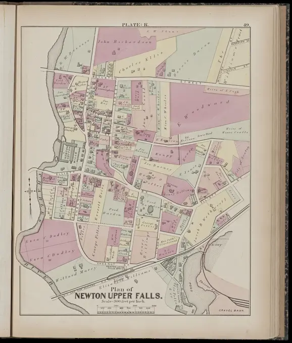
Detailed historic maps of Boston areas such as West Roxbury and Brookline, depicting landowners and property layouts in colorful ink and engravings.

Atlas of the city of Newton, Massachusetts. plate 5 , Real property, Massachusetts, Newton, Maps, Landowners, Massachusetts, Newton, Maps, Newton Mass., Maps Norman B. Leventhal Map Center Collection
245 assets in this story
4443-75470113
Map of Oswego County, New York, created from actual surveys in 1854 by Gillette, Matthews & Co. The map is hand-colored and measures 125 x 140 cm, with the sheet size being 128 x 148 cm. It includes detailed information about landowners and administrative and political divisions within Oswego County, encompassing towns such as Hannibal, Cleveland, Pulaski, Oswego, and Mexico. The publisher is located at No. 15 Minor Street, Philadelphia
6145-52831141
An 1823 multicolored graphite drawing by Johann Aman showing a copy of the reconstructed floor plan of Vienna from 1529, emphasizing streets, buildings, and urban layout.
6145-59242344
Schouwburg van den War (page XXXIV), ca. 1705-1710, 1720 - 1722 print Leaf with the weapons of German princes, lists of the kreps, government cities, card of Germany, etc. Inscriptions in the show in Dutch. PLAD XXXIV In: Schouwburg van den War (edition of 1720), the print work with the bundled series of 31 plates on the Spanish Succession War. Amsterdam paper etching weapons Germany
6145-29095971
(Lower left) detail, from- 1839 Woodblock Ino Tadataka Atlas of Japan or Kokugun Zenzu ( 2 volumes )
6145-55175495
New York (N.Y.). Bureau of Engineering. Cartographic, Maps. 1924. Lionel Pincus and Princess Firyal Map Division. New York (N.Y.) 22C - N.Y. City (Aerial Set).
6145-50529980
Atlas of the city of Newton, Middlesex Co., Massachusetts : from actual survey, official records & private plans. section K , Real property, Massachusetts, Newton, Maps, Landowners, Massachusetts, Newton, Maps, Newton Mass., Maps Norman B. Leventhal Map Center Collection
4443-75469615
Double Page Plate No. 9 Westchester County - Yonkers to Dobbs Ferry - East to State Line, 1891, Publisher, Julius Bien & Co., New York, 1 map in 2 sections; color; each 45 x 60 cm
6145-48719554
Atlas of the city of Newton, Middlesex Co., Massachusetts : from actual survey, official records & private plans. section K , Real property, Massachusetts, Newton, Maps, Landowners, Massachusetts, Newton, Maps, Newton Mass., Maps Norman B. Leventhal Map Center Collection
6145-55181323
Cooperstown Village; Laurens Business Directory. ; Cooperstown Business Directory. ; Laurens Village Cartographic. Atlases, Maps. 1868. Lionel Pincus and Princess Firyal Map Division. Otsego County (N.Y.), Real property , New York (State) , Otsego County
6145-29095104
1861 Colton Map of New York City w- Brooklyn, Manhattan, and Hoboken
4409-17283207
PLANO DE LAS PALMAS EN 1590. Author: TORRIANI L. Location: MUSEO CANARIO. LAS PALMAS. GRAN CANARIA. SPAIN.
6145-50571325
Plan de la ville de Bouchain situé sur les rivieres de la Sensette, et de l'Escaut, dans le comté de Hainaut : assiegée par les troupes alliez, sous le commandement de Son Excellence le General Baron de Fagel, la nuit entre le 23 et 24 d'Aout on ouvrit la tranchée en trois endroits, et le 12 Septeme. a midi la garnison demanda a capituler : et a eté fait prisonniers de guerre , Spanish Succession, War of, 1701-1714, Bouchain France, History, Siege, 1711, Maps Norman B. Leventhal Map Center Collection
6145-52394690
Bird's eye view of Fargo, Dakota. 1850 - 1930. still image. Stereographs, Photographs. The Miriam and Ira D. Wallach Division of Art, Prints and Photographs: Photography Collection
6145-59061048
Warsaw plan with views of the most important buildings; Schmidtner, Leonhard (1799-1873), Knusman, Daniel (Warsaw; Litographic Zak 1821-1826); 1837 (1837-00-00-1837-00-00);Kingdom of Poland (1815-1918), Warsaw (Masovian Voivodeship), Witke-Jeżewski, Dominik (1862-1944), Witke-Jeżewski, Dominik (1862-1944)-collection, Polish graphics, city plans, Poland (culture), Purchase (provenance)
6145-30264658
Plan from Vienna and its suburbs, Plan from Vienna and its suburbs, Artaria , Co, Verlag, Publishing House
6145-54549386
Fort Covington Village Cartographic. Atlases, Maps. 1876. Lionel Pincus and Princess Firyal Map Division. Franklin County (N.Y.), Real property , New York (State)
4409-14424
PLANO DE LA PLAZA DE MALAGA1750. Location: SERVICIO GEOGRAFICO DEL EJERCITO. MADRID. SPAIN.
6145-59474088
Map of Honfleur, Anonymous, After Jacques Gomboust, 1657 print This print is part of an album. publisher: Frankfurt am MainThe Hague paper engraving / etching maps of cities Honfleur
6145-50569394
Illustrated map of Paris : or stranger's guide to the public buildings, theatres, and all places of amusement , Paris France, Maps Norman B. Leventhal Map Center Collection
6145-50561877
Map of North Broadway, Lawrence, Massachusetts , Rivers, Streets. Lawrence
6145-55175501
New York (N.Y.). Bureau of Engineering. Cartographic, Maps. 1924. Lionel Pincus and Princess Firyal Map Division. New York (N.Y.) 33A - N.Y. City (Aerial Set).
4409-17339316
Napoleonic map. Surroundings of Montereau, France. Atlas de l'Histoire du Consulat et de l'Empire. History of the Consulate and the Empire of France under Napoleon by Marie Joseph Louis Adolphe Thiers (1797-1877). Drawings by Dufour, engravings by Dyonnet. Edited in Paris, 1864.
6145-51395813
Neuester situations-plan von Prag : nach einer originalzeichnung gestochen von C. Stein in Wien , Prague Czech Republic, Maps Norman B. Leventhal Map Center Collection
6145-55955182
Map of City of Ithaca, N.Y.: from actual surveys and records Cartographic. Maps, Cadastral maps. 1889. Lionel Pincus and Princess Firyal Map Division. Real property , New York (State) , Ithaca, Landowners , New York (State) , Ithaca, Ithaca (N.Y.), Ithaca (N.Y.) , Administrative and political divisions
6145-55956592
City of New-York Cartographic. Maps. 1840. Lionel Pincus and Princess Firyal Map Division. Newburgh (N.Y.), Manhattan (New York, N.Y.) , Maps, New York (N.Y.) , Administrative and political divisions , Maps, New York (N.Y.) , Maps
6145-50567305
Map of the city of Cambridge , Cambridge Mass., Maps Norman B. Leventhal Map Center Collection
1788-38161
Cartography, Netherlands, 16th century. Map of Leiden city and region. From Civitates Orbis Terrarum by Georg Braun (1541-1622) and Franz Hogenberg (1540-1590), Cologne. Engraving
6145-55956738
Bird's eye view map of New York and vicinity Cartographic. Maps. 1909. Lionel Pincus and Princess Firyal Map Division. New York Metropolitan Area , Maps, New York Metropolitan Area , Aerial views
6145-55926265
Cartographic, Maps. 1868. Lionel Pincus and Princess Firyal Map Division. Real property , New York Metropolitan Area, Westchester County (N.Y.), New York Metropolitan Area Plate 28: Plan of Tarrytown and vicinity, Westchester Co. N.Y. Large folder - L1
6145-44073485
Maps for slide lectures. Reproduction of a map of Genoa. Cutout with the harbor
6145-55175479
New York (N.Y.). Bureau of Engineering. Cartographic, Maps. 1924. Lionel Pincus and Princess Firyal Map Division. New York (N.Y.) 13A - N.Y. City (Aerial Set).
6145-51396929
View of Springfield, Mass : 1875 , Springfield Mass., Aerial views Norman B. Leventhal Map Center Collection
6145-29095948
Rue de Vouillé 1889 Vuillemin
6145-54549505
North Part of Cazenovia Village Cartographic. Atlases, Maps. 1875. Lionel Pincus and Princess Firyal Map Division. Madison County (N.Y.), Real property , New York (State) , Madison County, Business enterprises , New York (State) , Madison County
1525-25111586
Antique map of town and citadel of Liege, Atlas of fortifications and battles, by Anna Beek and Gaspar Baillieu  Originally published in 17th century.
6145-50661344
Map of the city of Utrecht with immediate surroundings; with representation of the defenses; With roads, waterways and stylized representation of the buildings and land use uprising outside the Stadsbuitengracht.
6145-59588774
Map of the Dijkgraafschap Drechterland (part at the top right), Anonymous, 1775 print Part (top right) of a map of the Drechterland Dijkgraafschap.  paper engraving / etching maps of separate countries or regions. polder, reclaimed land Drechterland
6145-55956953
The Transval of New York Cartographic. Maps. 1880. Lionel Pincus and Princess Firyal Map Division. New York (N.Y.), New York (N.Y.) , History , Revolution, 1775-1783, New York (N.Y.) , History, 1775-1865, Manhattan (New York, N.Y.), Harlem (New York, N.Y.), Washington Heights (New York, N.Y.), Fort George (New York, N.Y.), Inwood (New York, N.Y.), Fortification , New York (State) , New York (N.Y.)
6145-55175505
New York (N.Y.). Bureau of Engineering. Cartographic, Maps. 1924. Lionel Pincus and Princess Firyal Map Division. New York (N.Y.) 6C - N.Y. City (Aerial Set).
4409-22249
PROYECTO PARA LA REFORMA DE LA PUERTA DEL SOL - LITOGRAFIA - MADRID 1860. Location: CONGRESO DE LOS DIPUTADOS-BIBLIOTECA. SPAIN.
6145-54549436
Valatie Village Bourquin, F. (Frederick), 1808-. Cartographic. Atlases, Maps. 1873. Lionel Pincus and Princess Firyal Map Division. Columbia County (N.Y.), Real property , New York (State) , Columbia County, Business enterprises , New York (State) , Columbia County
6145-54549515
The Village of Amsterdam Village; Amsterdam Business Directory Cartographic. Atlases, Maps. 1868. Lionel Pincus and Princess Firyal Map Division. Real property , New York (State) , Montgomery County, Real property , New York (State) , Fulton County, Montgomery County (N.Y.), Fulton County (N.Y.)
4409-20923992
DETAIL OF THE MAP OF THE CITY OF MEXICO AND ITS SURROUNDINGS - 1753. Location: ACADEMIA DE LA HISTORIA-COLECCION. MADRID. SPAIN.
6145-55167336
Nuova pianta degli scavi di Pompei. Includes key to points of interest. Inset: Neapolis and environs.... , Italy  , Koni  ,region   , Napoli  ,province   , Pompeii  ,area
6145-48718271
Nuova pianta degli scavi di Pompei , Excavations Archaeology, Italy, Pompeii Extinct city, Maps, Pompeii Extinct city, Maps Norman B. Leventhal Map Center Collection
PREVIOUS
of 3
NEXT
2401 S. Ervay, Suite 206
Dallas, Texas 75215
United States
Get Started
Free ResearchMy BoardsMy Cart
For Creators
How To License Your ContentContributor PortalFrame of Mind
Resources
API accessPricing
Contact
+1 866 236 0087help@viewpictures.co.uk Contact form
©2026 View Pictures. All Rights Reserved. -A
This site is protected by reCAPTCHA and Google Privacy Policy and Terms of Service apply.