My Boards
View Pictures
  • My Boards
← Documents & Records

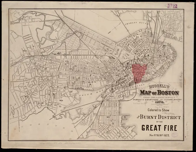
Maps of Boston and Surroundings

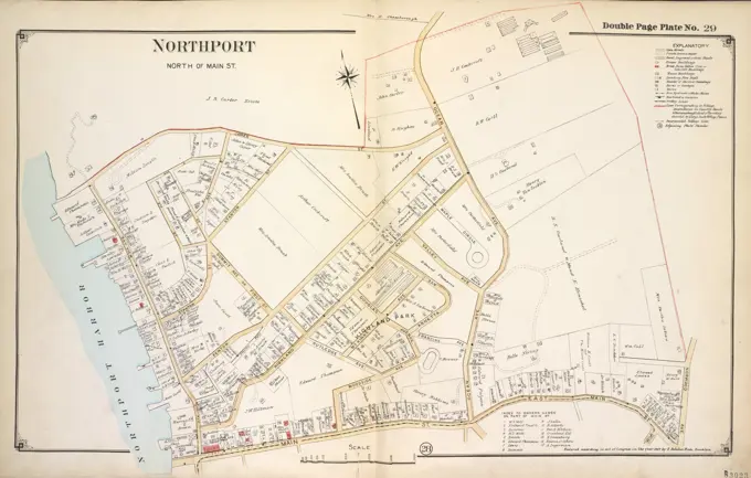
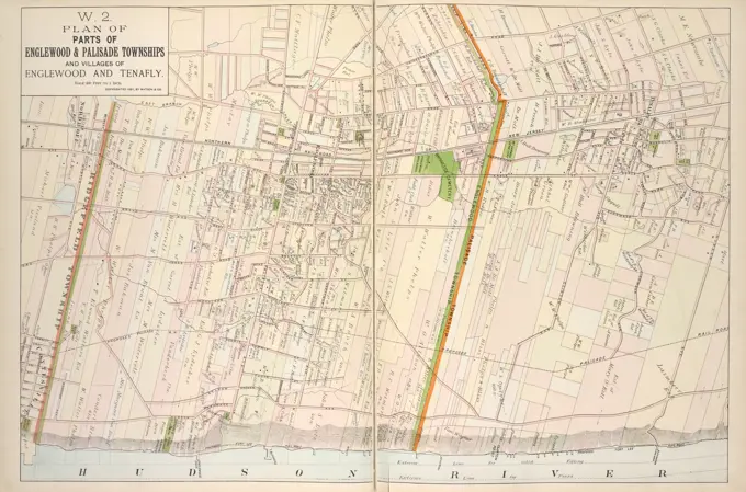
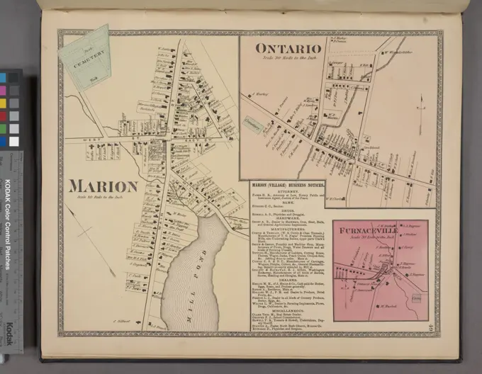
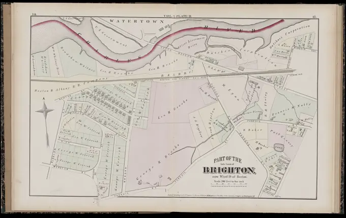
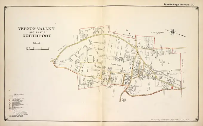
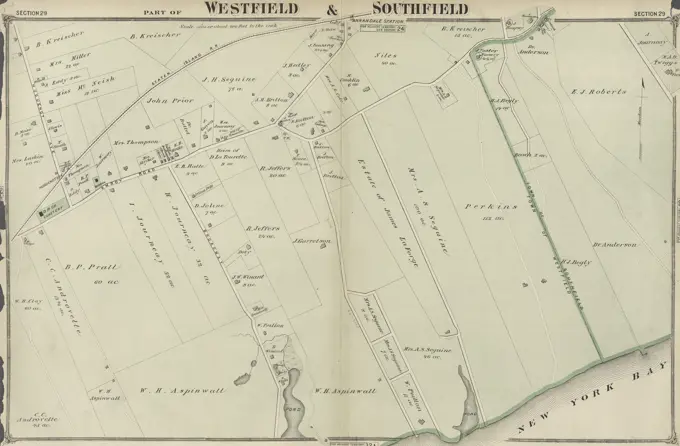
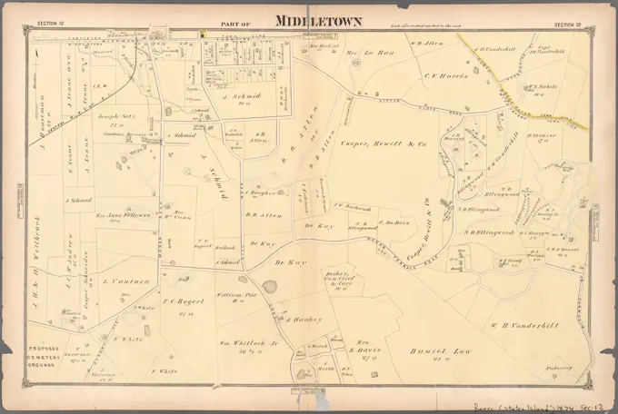
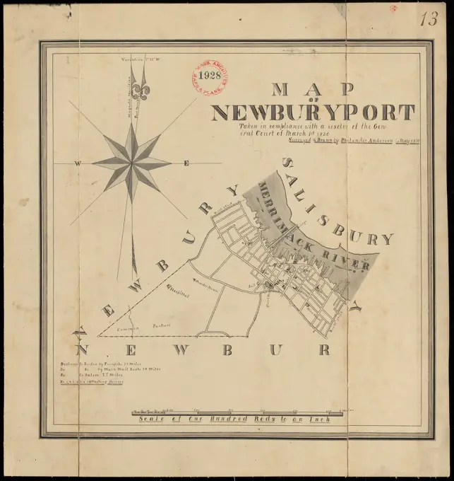
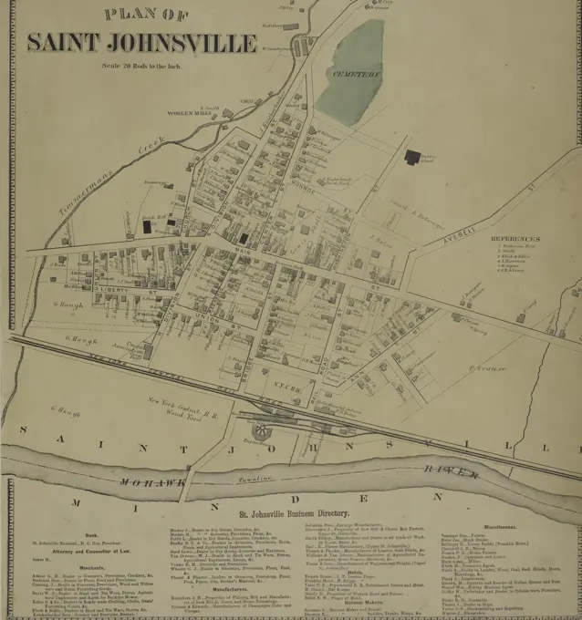
Detailed maps from the city of Boston and West Roxbury, showcasing land ownership and layouts from the late 19th century, in a clear, organized style.

Atlas of the city of Boston, West Roxbury : plate 5 , Boston Mass., Maps, Real property, Massachusetts, Boston, Maps, Landowners, Massachusetts, Boston, Maps, Jamaica Plain Boston, Mass., Maps Norman B. Leventhal Map Center Collection
452 assets in this story
6145-54267814
Map of Andersonville, Sumter Co., Georgia. Manuscript map in ink showing Andersonville and the military prison and graveyard used by the confederates during the American Civil War. Relief shown by contours. Carleton sent to Andersonville in May 1865 to produce a topographical survey of the prison and its surroundings, and submitted map and field notes to Major General H. Wilson before his release in June 1865.... , Georgia  , Sumter  ,county   , Andersonville National Historical Site Georgia  , Sumter  ,county   , Andersonville
6145-55957649
Smith Town Branch Cartographic. Atlases, Maps. 1915 - 1917. Lionel Pincus and Princess Firyal Map Division. Suffolk County (N.Y.)
6145-48719433
Hyde Park & Fairmount : in Dorchester & Milton, Norfolk Co , Real property, Massachusetts, Boston, Maps, Land tenure, Massachusetts, Boston, Maps, Real property, Massachusetts, Milton, Maps, Land tenure, Massachusetts, Milton, Maps, Hyde Park Boston, Mass., Maps, Milton Mass., Maps, Hyde Park Boston, Mass. Norman B. Leventhal Map Center Collection
6145-55957651
Northport North of Main St. Cartographic. Atlases, Maps. 1915 - 1917. Lionel Pincus and Princess Firyal Map Division. Suffolk County (N.Y.)
6145-55916380
Plan of Oak Bluffs, Marthas Vineyard. June 1st 1871. Includes six illustrations of buildings.... , Massachusetts  , Dukes  ,county   , Martha's Vineyard  ,island   , Oak Bluffs
6145-48446765
Jansen Hermann (1869-1945), development plan Kleinsiedlung Norden, Rathenow (01.04.1921): Grund- and site plan 1: 2500. Ink on transparent, 60.3 x 46.6 cm (including scan edges) Jansen Hermann  (1869-1945): Bebauungsplan Kleinsiedlung Norden, Rathenow
6145-55958640
Union County, Double Page Plate No. 31 Map of Village of Scotch Plains, map of Fanwood Township, map of Fanwood Borough 1906. Bauer, Jacob L.. Cartographic. Atlases, Maps. Lionel Pincus and Princess Firyal Map Division. Union County (N.J.)
6145-55957737
Plan of Parts of Englewood & Palisade Townships and Villages of Englewood and Tenafly. Cartographic. Atlases, Maps. 1891. Lionel Pincus and Princess Firyal Map Division. Hudson River Valley (N.Y. and N.J.), New York (State)
6145-43861827
Pittsfield , Pittsfield Mass., Maps, Railroads, Massachusetts, Pittsfield, Maps Norman B. Leventhal Map Center Collection
6145-50570267
Atlas of the county of Suffolk, Massachusetts : vol. 2nd late city of Roxbury, now wards 13-14 and 15, city of Boston : plate M , Real property, Massachusetts, Boston, Maps, Landowners, Massachusetts, Boston, Maps, Roxbury Boston, Mass., Maps, Jamaica Plain Boston, Mass., Maps Norman B. Leventhal Map Center Collection
6145-48447477
Jansen Hermann (1869-1945), Planning for Plowdiw (22.12.1943): Department of Garden »Zar Simeon«, Gladstonestrasse 1: 1000 (variant for Inv.No. 22336). Pencil on transparent, 34.6 x 31 cm (including scan edges) Jansen Hermann  (1869-1945): Planung für Plowdiw
6145-55957655
Part of Port Jefferson and Part of Port Jefferson Station Cartographic. Atlases, Maps. 1915 - 1917. Lionel Pincus and Princess Firyal Map Division. Suffolk County (N.Y.)
6145-50530033
Atlas of the town of Brookline, Massachusetts : from actual surveys & official records. plate A , Real property, Massachusetts, Brookline, Maps, Landowners, Massachusetts, Brookline, Maps, Brookline Mass., Maps Norman B. Leventhal Map Center Collection
6145-55181239
Ontario Village; Furnaceville Village; Marion (Village) Business Directory; Marion Village Cartographic. Atlases, Maps. 1874. Lionel Pincus and Princess Firyal Map Division. Real property , New York (State) , Wayne County, Wayne County (N.Y.), Business enterprises , New York (State) , Wayne County
6145-55916143
Plan of a part of Cambridge showing the location of the Fayerweather Estate. Oriented with north toward the upper left. Includes places of interest. "Boston. Feb. 1852."... , Massachusetts  , Middlesex  ,county   , Cambridge
6145-55175391
Cartographic, Maps. 1901. Lionel Pincus and Princess Firyal Map Division. Queens (New York, N.Y.) Index Map to Volume One
6145-55958639
Union County, Double Page Plate No. 27 Map of part of Summit 1906. Bauer, Jacob L.. Cartographic. Atlases, Maps. Lionel Pincus and Princess Firyal Map Division. Union County (N.J.)
6145-52359708
Horse Heads Village; Horse Heads Subscriber's Business Directory Cartographic. Atlases, Maps. 1869. Lionel Pincus and Princess Firyal Map Division. Chemung County (N.Y.), Real property , New York (State) , Chemung County, Business enterprises , New York (State) , Chemung County
6145-48447125
Jansen Hermann (1869-1945), total development plan Ankara. Partial development plan exterior (10.03.1931): Basic plan 1: 2000, southwestern expansion of the city. Pencil, colored pencil on transparent, 103.9 x 88.9 cm (including scan edges) Jansen Hermann  (1869-1945): Gesamtbebauungsplan Ankara. Teilbebauungsplan äußere Stadt
6145-51390917
Atlas of the city of Cambridge, Middlesex Co., Massachusetts. plate G , Real property, Massachusetts, Cambridge, Maps, Landowners, Massachusetts, Cambridge, Maps, Cambridge Mass., Maps Norman B. Leventhal Map Center Collection
6145-51390016
Atlas of the city of Boston, Charlestown : plate 22 , Boston Mass., Maps, Real property, Massachusetts, Boston, Maps, Landowners, Massachusetts, Boston, Maps, Charlestown Boston, Mass., Maps Norman B. Leventhal Map Center Collection
6145-48488679
N.N., fog horn signal system, Pillau: site plan 1: 5000. Lithograph colored on paper, 38.1 x 51.6 cm (including scan edges)
6145-55926820
Cartographic, Maps. 1874. Lionel Pincus and Princess Firyal Map Division. Staten Island (New York, N.Y.) Part of Westfield Section 28
6145-59428559
Map with the lines of the Amsterdam Omnibus, 1839, Anonymous, 1839 print Map of the city of Amsterdam on which the line network of the Omnibus of the Amsterdamsche Omnibus company are indicated. Central the map with the colored routes, left the regulations for the services and on the right the description of the 18 lines. Amsterdam paper  maps of cities. diligence, omnibus, horse-tram Amsterdam
6145-55167545
Plan of the Highlands, the property of the Vineyard Grove Co : Cottage City, Mass. Oriented with north toward the upper right. Advertisment for sale of lots on verso.... , Massachusetts  , Dukes  ,county   , Martha's Vineyard  ,island   , Oak Bluffs
6145-50570736
Atlas of the city of Cambridge, Middlesex Co., Massachusetts. plate H , Real property, Massachusetts, Cambridge, Maps, Landowners, Massachusetts, Cambridge, Maps, Cambridge Mass., Maps Norman B. Leventhal Map Center Collection
6145-55181556
Essex County, V. 3, Double Page Plate No. 25 Map of town of Montclair A.H. Mueller (Publisher). Cartographic. Atlases, Maps. 1906. Lionel Pincus and Princess Firyal Map Division. Essex County (N.J.), Newark (N.J.)
6145-50570449
Atlas of the town of Brookline, Massachusetts : from actual surveys & official records. plate A , Real property, Massachusetts, Brookline, Maps, Landowners, Massachusetts, Brookline, Maps, Brookline Mass., Maps Norman B. Leventhal Map Center Collection
4409-21508683
Unionport, Schuylerville. Westchester, N.Y., 1872.
6145-48719367
Atlas of Suffolk, county, vol. 7th, late town of Brighton, now ward 19 of Boston, Massachusetts : from actual survey & official records : plate B , Real property, Massachusetts, Boston, Maps, Landowners, Massachusetts, Boston, Maps, Brighton Boston, Mass., Maps Norman B. Leventhal Map Center Collection
6145-48718642
Plan of Lafayette College grounds Easton, Pa , Lafayette College Easton, Pa., Maps, Manuscript, Easton Northampton County, Pa., Maps, Manuscript Norman B. Leventhal Map Center Collection
4443-75462018
Brush's Mills Village, Moira Village, and Whippleville Village, 1876., 1876., Philadelphia, Franklin County, New York. Topic Real property in New York State
6145-48719520
Atlas of the city of Cambridge, Middlesex Co., Massachusetts. plate O , Real property, Massachusetts, Cambridge, Maps, Landowners, Massachusetts, Cambridge, Maps, Cambridge Mass., Maps Norman B. Leventhal Map Center Collection
6145-50529579
Atlas of Suffolk, county, vol. 7th, late town of Brighton, now ward 19 of Boston, Massachusetts : from actual survey & official records : plate C , Real property, Massachusetts, Boston, Maps, Landowners, Massachusetts, Boston, Maps, Brighton Boston, Mass., Maps Norman B. Leventhal Map Center Collection
6145-52358980
A map shewing the extent of the great fire which broke out about 9 O'Clock on the night of the 16th December 1835, in the City of New-York Cartographic. Maps. 1836. Lionel Pincus and Princess Firyal Map Division. Fires , New York (State) , New York, Lower Manhattan (New York, N.Y.), Manhattan (New York, N.Y.), New York (N.Y.)
6145-51385942
A plan of Andover taken for the town , Real property, Massachusetts, Andover Town, Maps, Landowners, Massachusetts, Andover Town, Maps, Real property, Massachusetts, North Andover Town, Maps, Landowners, Massachusetts, North Andover Town, Maps, Real property, Massachusetts, Lawrence, Maps, Landowners, Massachusetts, Lawrence, Maps, Andover Mass. : Town, Maps, North Andover Mass. : Town, Maps, Lawrence Mass., Maps, Andover Mass. : Town, Buildings, structures, etc, Maps Norman B. Leventhal Map Center Collection
6145-55957654
Vernon Valley and Part of Northport Cartographic. Atlases, Maps. 1915 - 1917. Lionel Pincus and Princess Firyal Map Division. Suffolk County (N.Y.)
6145-50568228
Russell's map of Boston from the latest surveys : colored to show the burned district of the Great Fire Nov 9th & 10th 1872 , Great Fire, Boston, Mass., 1872, Maps, Boston Mass., Maps Norman B. Leventhal Map Center Collection
4443-75470087
Map of the city of Topeka, Shawnee County, Kansas population 40,000, 1887. Published by Bartholomew & Co., 1887., No. 189 Kansas Avenue, Topeka, Kansas., 1 map color; 53 x 68 cm, on sheet 56 x 71 cm. Includes manuscript notations in red ink
6145-30308446
Plan of the city of Vienna and the suburbs, in  leaves sheet , Carl Gerolds son, publishing house
6145-55955886
Map of the town of Flatbush, Kings Co. L.I. Cartographic. Maps, Cadastral maps. 1842. Lionel Pincus and Princess Firyal Map Division. Real property , New York (State) , New York, Brooklyn (New York, N.Y.), Flatbush (New York, N.Y.), Flatlands (New York, N.Y.)
4443-75472309
Part of Westfield & Southfield, Section 29, issued in 1874 by J.B. Beers & Co., New York
6145-55926806
Cartographic, Maps. 1874. Lionel Pincus and Princess Firyal Map Division. Staten Island (New York, N.Y.) Part of Middletown Section 12
6145-51389185
Winchendon , Landowners, Massachusetts, Winchendon Town, Maps, Winchendon Mass. : Town, Maps Norman B. Leventhal Map Center Collection
6145-48559634
Plan of Newburyport made by Philander Anderson, dated May 1830 ,. Massachusetts. Office of the Secretary of State
6145-55181303
Holley Business Notices; Holley Village Cartographic. Atlases, Maps. 1875. Lionel Pincus and Princess Firyal Map Division. Niagara County (N.Y.), Orleans County (N.Y.), Real property , New York (State) , Niagara County, Real property , New York (State) , Orleans County
6145-48447698
Jansen Hermann (1869-1945), total development plan Ankara. Partial development plan Outer Stadt (March 18, 1932): Basic plan 1: 4000, area north of the new Dikmen Caddesi. Pencil and colored pencil on transparent, 17.2 x 22.2 cm (including scan edges) Jansen Hermann  (1869-1945): Gesamtbebauungsplan Ankara. Teilbebauungsplan äußere Stadt
6145-48718023
Washington Street boulevard study : corridor wide urban design strategy , City planning, Massachusetts, Boston, Maps, Urban renewal, Massachusetts, Boston, Maps, Washington Street Boston, Mass., Maps Norman B. Leventhal Map Center Collection
4443-75466061
Plan of Saint Johnsville Village from the St. Johnsville Business Directory, issued in 1868, published by Stranahan & Nichols. The plan details real property in Montgomery County and Fulton County in New York State
6145-52359735
Plan of Saint Johnsville Village; St. johnsville Business Directory Cartographic. Atlases, Maps. 1868. Lionel Pincus and Princess Firyal Map Division. Real property , New York (State) , Montgomery County, Real property , New York (State) , Fulton County, Montgomery County (N.Y.), Fulton County (N.Y.)
6145-48719571
Atlas of the towns of Revere and Winthrop, Suffolk County, Massachusetts. sheet 17 , Real property, Massachusetts, Revere, Maps, Landowners, Massachusetts, Revere, Maps, Revere Mass., Maps Norman B. Leventhal Map Center Collection
4443-75470405
Winfield, Tn. of Newtown, Queens Co., 1873, published by Beers, Comstock & Cline in New York
PREVIOUS
of 5
NEXT
2401 S. Ervay, Suite 206
Dallas, Texas 75215
United States
Get Started
Free ResearchMy BoardsMy Cart
For Creators
How To License Your ContentContributor PortalFrame of Mind
Resources
API accessPricing
Contact
+1 866 236 0087help@viewpictures.co.uk Contact form
©2026 View Pictures. All Rights Reserved. -A
This site is protected by reCAPTCHA and Google Privacy Policy and Terms of Service apply.