My Boards
View Pictures
  • My Boards
← Documents & Records

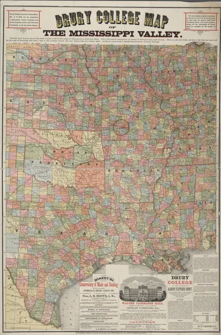
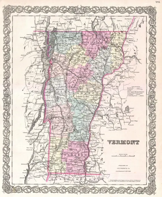
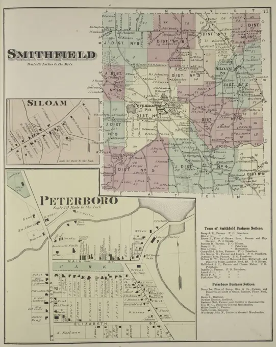
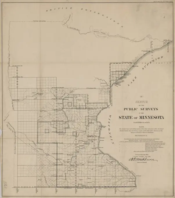
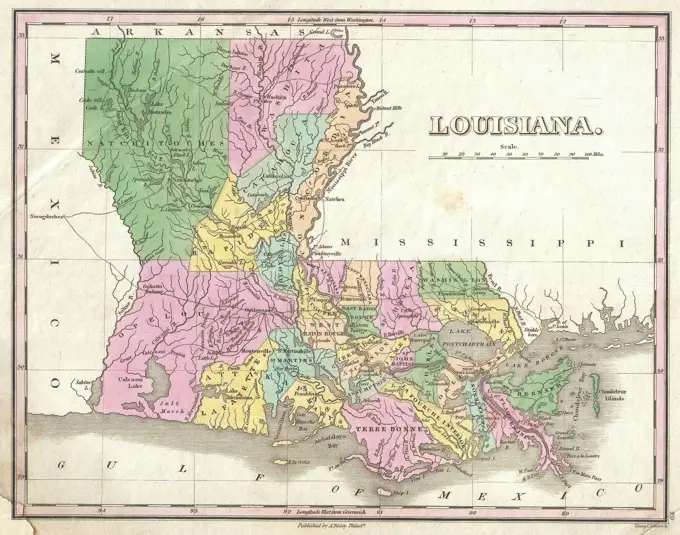
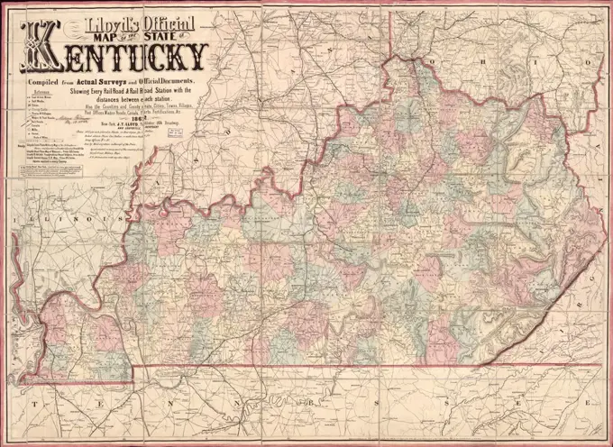
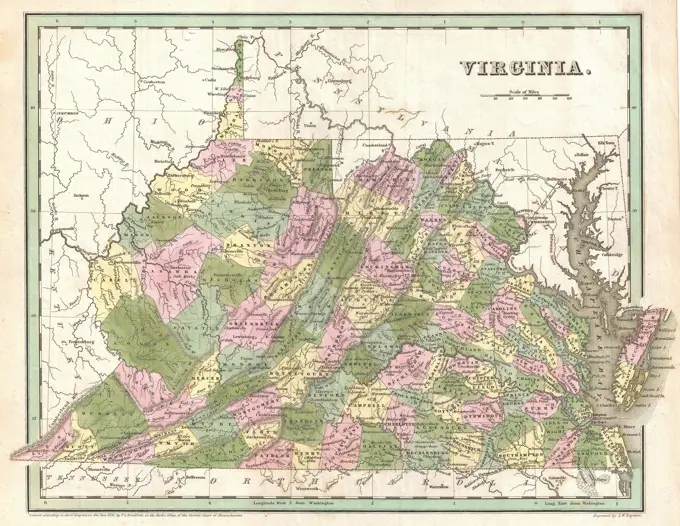
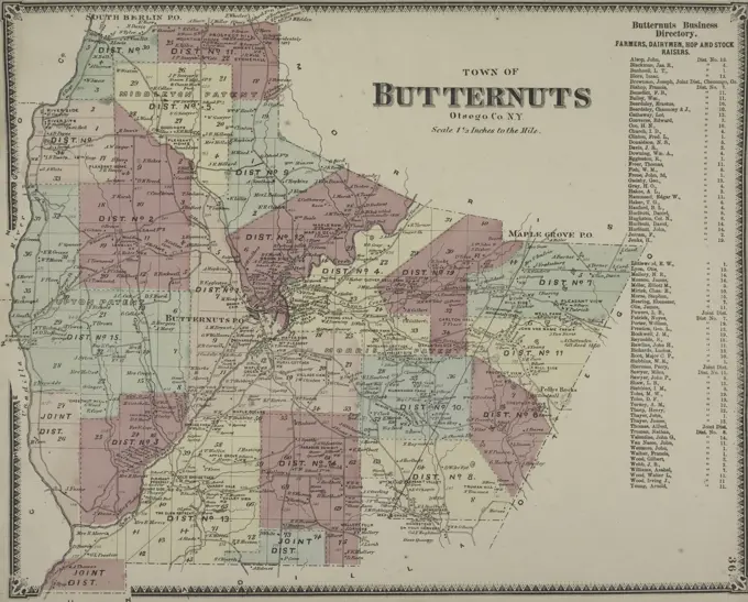
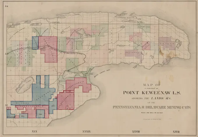
Maps of North America

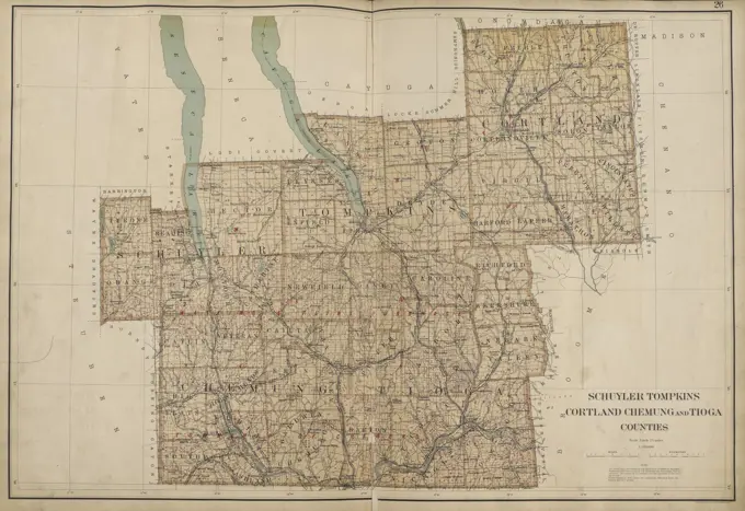
Detailed vintage maps depicting postal routes and counties across North America, featuring intricate cartographic designs.

Double Page Plate No. 26 Map of Schuyler, Tompkins, Cortland, Chemung, and Tioga Counties, 1895, published by Joseph R. Bien in New York
256 assets in this story
6145-55181044
Ira Township Cartographic. Atlases, Maps. 1875. Lionel Pincus and Princess Firyal Map Division. Cayuga County (N.Y.), Real property , New York (State) , Cayuga County
6145-51396548
Map of the counties of Lanark and Renfrew, Canada West : from actual surveys under the direction of H.F. Walling , Landowners, Ontario, Lanark County, Maps, Landowners, Ontario, Renfrew County, Maps, Lanark Ont. : County, Maps, Renfrew Ont. : County, Maps Norman B. Leventhal Map Center Collection
6145-55914825
Map of the county of Hampshire, Massachusetts : based upon the trigonometrical survey of the state. Includes 38 insets of village centers (scales vary); table of distances; geologic map; statistics for population, manufacturing and agriculture in 1855; illustrations of Williston Seminary and Amherst College with lists of faculty; illustrations of State Lunatic Hospital in Northampton and Mount Holyoke Female Seminary in South Hadley. Shows householders' names.... , Massachusetts  , Hampshire  ,county
6145-51392008
Cereal map of Alberta : showing acreage under crop in each township in wheat, oats, barley and flax , Flax, Alberta, Maps, Barley, Alberta, Maps, Wheat, Alberta, Maps, Oats, Alberta, Maps, Grain, Alberta, Maps, Alberta, Maps Norman B. Leventhal Map Center Collection
6145-55913027
Cereal map of Alberta : showing acreage under crop in each township in wheat, oats, barley and flax. Relief shown by spot heights. Includes statistics. "From data supplied by the Provincial Government and the Census Branch, Department of Trade and Commerce." "Crop 1913."... , Canada  , Province of Alberta  ,province
6145-51396417
Cereal map of Alberta : showing acreage under crop in each township in wheat, oats, barley and flax , Flax, Alberta, Maps, Barley, Alberta, Maps, Wheat, Alberta, Maps, Oats, Alberta, Maps, Grain, Alberta, Maps, Alberta, Maps Norman B. Leventhal Map Center Collection
6145-55914246
Manitoba : map showing disposition of lands. Inset: Map of Manitoba showing Dominion Land Agencies... Map showing disposition of lands. Map showing disposition of lands, Canada  , Province of Manitoba  ,province
4443-75458598
Drury College map of the Mississippi Valley, 1878. Published by Drury College in Springfield, Mo., and printed by Woodward, Tiernan & Hale in St. Louis. The map is in color and measures 101 x 68 cm
4443-75468615
State of Minnesota, 1879, United States. Phoenix General Land Office., 1879., Washington, D.C. Publisher, General Land Office, Minnesota. Administrative and political divisions., 1 map, color; 79 x 63 cm, on sheet 83 x 67 cm
6145-54549079
Black Brook Township; Black Brook Subscriber's Business Directory. Cartographic. Atlases, Maps. 1869. Lionel Pincus and Princess Firyal Map Division. Clinton County (N.Y.)
6145-55181167
Avoca Township; Wallace Village Cartographic. Atlases, Maps. 1873. Lionel Pincus and Princess Firyal Map Division. Steuben County (N.Y.), Real property , New York (State) , Steuben County, Business enterprises , New York (State) , Steuben County
6145-55181287
Royalton Township Cartographic. Atlases, Maps. 1875. Lionel Pincus and Princess Firyal Map Division. Niagara County (N.Y.), Orleans County (N.Y.), Real property , New York (State) , Niagara County, Real property , New York (State) , Orleans County
6145-51396814
Map of New Milford, Litchfield Co., Conn , Real property, Connecticut, New Milford, Maps, New Milford Conn., Maps Norman B. Leventhal Map Center Collection
6145-51394709
Map of New Milford, Litchfield Co., Conn , Real property, Connecticut, New Milford, Maps, New Milford Conn., Maps Norman B. Leventhal Map Center Collection
6145-55914573
Map of New Milford, Litchfield Co., Conn. Shows buildings and householders' names. Shows districts. Relief shown by hachures. Lithograph of Friend & Aub. Includes views of local buildings. Insets: New Milford -- Bridgewater.... , Connecticut  , Litchfield  ,county   , New Milford
6145-29094891
1855 Colton Map of Vermont
6145-54548961
Map of the county of Niagara 1829 - 1839. Cartographic. Atlases, Maps. Lionel Pincus and Princess Firyal Map Division. New York (N.Y.), Niagara County (N.Y.) , Maps, Real property , New York (State) , Niagara County
6145-55181176
Caton Center Village; Caton Business Notices; Caton Township Cartographic. Atlases, Maps. 1873. Lionel Pincus and Princess Firyal Map Division. Steuben County (N.Y.), Real property , New York (State) , Steuben County, Business enterprises , New York (State) , Steuben County
6145-50548235
Indian Territory , Indian Territory, Maps, Oklahoma, Maps, Indian reservations, Oklahoma, Maps Norman B. Leventhal Map Center Collection
6145-54548954
Map of the county of Rensselaer 1829 - 1839. Cartographic. Atlases, Maps. Lionel Pincus and Princess Firyal Map Division. New York (N.Y.), Landowners , New York (State) , Rensselaer County, Real property , New York (State) , Rensselaer County, Rensselaer County (N.Y.) , Maps
6145-55181064
Catlin Business Directory; Catlin Township Cartographic. Atlases, Maps. 1869. Lionel Pincus and Princess Firyal Map Division. Chemung County (N.Y.), Real property , New York (State) , Chemung County, Business enterprises , New York (State) , Chemung County
4443-75467229
Business notices from Smithfield Township, Siloam Village, and Peterboro Village, issued in 1875. Published in Philadelphia by Pomeroy, Whitman, focusing on real property and business enterprises in Madison County, New York
6145-55181021
Chateaugay Township Cartographic. Atlases, Maps. 1876. Lionel Pincus and Princess Firyal Map Division. Franklin County (N.Y.), Real property , New York (State)
4443-75458304
Map of Alabama, 1838, by T.G. Bradford, published in Boston, Massachusetts. The map is hand-colored and measures 35 x 27 cm, printed on a sheet that is 40 x 33 cm. It depicts the administrative and political divisions of Alabama
6145-48718566
Indian Territory showing railroad systems - June 30, 1902 , Indian Territory, Maps, Oklahoma, Maps, Railroads, Indian Territory, Maps, Railroads, Oklahoma, Maps, Indian reservations, Oklahoma, Maps Norman B. Leventhal Map Center Collection
4443-75466338
This is a sketch map of public surveys in Michigan from 1854, produced by the Surveyor General's Office. The map, measuring 54 x 56 cm and mounted on a sheet of 59 x 60 cm, highlights various surveying details of Michigan, including Isle Royale. The map is attributed to the Surveyor General of Ohio, Indiana, and Michigan and was issued in Detroit, Michigan
4443-75468814
Sketch of the public surveys in the state of Minnesota, issued in 1861 by the Surveyor General's Office in St. Paul, Minn. The map has an extent of 1 map measuring 58 x 51 cm, printed on a sheet that measures 62 x 56 cm
6145-51396219
Map of Kalamazoo Co., Michigan , Buildings, Michigan, Kalamazoo County, Pictorial works, Landowners, Michigan, Kalamazoo County, Maps, Real property, Michigan, Kalamazoo County, Maps, Kalamazoo County Mich., Maps, Augusta Mich., Maps, Galesburg Mich., Maps, Kalamazoo Mich., Maps, Schoolcraft Mich., Maps, Vicksburg Mich., Maps Norman B. Leventhal Map Center Collection
6145-55181347
Tyrone Township Cartographic. Atlases, Maps. 1874. Lionel Pincus and Princess Firyal Map Division. Schuyler County (N.Y.), New York (State) , Schuyler County
6145-29096543
1827 Finley Map of Louisiana
6145-50548232
Indian Territory showing railroad systems - June 30, 1902 , Indian Territory, Maps, Oklahoma, Maps, Railroads, Indian Territory, Maps, Railroads, Oklahoma, Maps, Indian reservations, Oklahoma, Maps Norman B. Leventhal Map Center Collection
6145-50595096
A830494B GENERAL TEST TEST SITE MAP BOBBY G EDWARDS (Project Engineer) MAY 3 83 EG&G/NTS PHOTO LAB Publication Date: 5/3/1983  EDGERTON, GERMESHAUSEN & GRIER; EG&G; GENERAL TEST; LOCATION; MAPS; MAPS-NTS; NEVADA; NEVADA TEST SITE; NTS; NUCLEAR ENERGY TECHNOLOGY; SITE MAP; TEST SITE MAP; TEST SITES  historical images. 1972 - 2012. Department of Energy. National Nuclear Security Administration. Photographs Related to Nuclear Weapons Testing at the Nevada Test Site.
6145-55915418
The National Publishing Company's new railroad, post-office and county map of Illinois : with complete index of all post-offices and railroad stations, giving populations and locations. Includes population figures and index. On cover: The Scarborough Company, Boston, Mass... Illinois. Illinois, Illinois
6145-51396848
Map of Hillsboro Co., New Hampshire , Real property, New Hampshire, Hillsborough County, Maps, Landowners, New Hampshire, Hillsborough County, Maps, Cities and towns, New Hampshire, Hillsborough County, Maps, Villages, New Hampshire, Hillsborough County, Maps, Hillsborough County N.H., Maps Norman B. Leventhal Map Center Collection
1838-22239207
Lloyd's official map of the State of Kentucky, Published by James T. Lloyd, New York, 1862
6145-51388076
State of Minnesota , Minnesota, Maps, 1887 Norman B. Leventhal Map Center Collection
6145-55181339
Catharine Township Cartographic. Atlases, Maps. 1874. Lionel Pincus and Princess Firyal Map Division. Schuyler County (N.Y.), New York (State) , Schuyler County
6145-51396818
Map of the state of Georgia , Real property, Georgia, Maps, Georgia, Maps, Georgia, Pictorial works Norman B. Leventhal Map Center Collection
6145-29096642
1838 Bradford Map of Virginia
6145-54549368
Meredith Township; Business Directory Meredith Square Cartographic. Atlases, Maps. 1869. Lionel Pincus and Princess Firyal Map Division. Delaware County (N.Y.)
6145-51395096
Map of the state of Georgia , Real property, Georgia, Maps, Georgia, Maps, Georgia, Pictorial works Norman B. Leventhal Map Center Collection
4443-75478615
Map of Rensselaerville Township, published in 1866 by Stone & Stewart in Philadelphia, covering Albany County, New York
6145-55927034
text. Maps. 1854. Lionel Pincus and Princess Firyal Map Division. Manhattan (New York, N.Y.), Real property , New York (State) , New York, Fire insurance Volume 7 Index Map
4443-75458362
Butternuts Business Directory, Town of Butternuts, Otsego County, N.Y., 1868, by F. W. Beers., 1868., New York, Otsego County; Real property, New York State, Otsego County
6145-55955328
Wheatland: from map of Monroe County Cartographic. Maps. 1880. Lionel Pincus and Princess Firyal Map Division. Wheatland (N.Y. : Town), Wheatland (N.Y. : Town) , Administrative and political divisions
6176-59912323
. Cyclopedia of American horticulture, comprising suggestions for cultivation of horticultural plants, descriptions of the species of fruits, vegetables, flowers, and ornamental plants sold in the United States and Canada, together with geographical and biographical sketches. Gardening. v' 1062 NATIVE PLANTS NEBRASKA NATIVE PLANTS. It has been said that Americans do not appreciate the indigenous plants of the country. This may have been true, but it is not true now. The desire for native and natural plants is one of the xromi- nent movements of the present time. It is not strange that wild
6145-50568551
Map of Richland Co., Ohio , Landowners, Ohio, Richland County, Maps, Real property, Ohio, Richland County, Maps, Richland County Ohio, Maps Norman B. Leventhal Map Center Collection
6145-55915668
A new sectional map of Florida. Shows county boundaries, land survey sections, and lands offered by the Associated Railway Land Department of Florida. "D.H. Elliott, general land agent. Prime meridians: Greenwich and Washington. Inset: Map illustrating the geographical position of Florida, also location of the railroad and steamship lines for commerce with other states, and the countries south and east of Gulf of Mexico.... , Florida
4443-75465190
Lockport Township; Rapids Village, 1875. Published by Beers, Upton & Co., Philadelphia. The map represents real property in Niagara County and Orleans County, New York
6145-55916882
Rand, McNally & Co.'s new sectional map of Kansas. Show counties, cities, reservations, and public land survey sections... New sectional map of Kansas. New sectional map of Kansas, Kansas
4443-75458167
Map of a portion of Point Keweenaw, Lake Superior, showing the lands of the Pennsylvania and Delaware Mining Companies. Issued between 1880 and 1889, the map is hand-colored and measures 39 x 56 cm on a sheet of 42 x 58 cm. The map includes some manuscript additions in the southwest corner. It pertains to mines and mineral resources in Keweenaw County, Michigan, focusing on copper mines, real property, and landowners in the area. The publisher is unidentified, and the place of publication is likely Detroit, Michigan
6176-59912334
. Cyclopedia of American horticulture, comprising suggestions for cultivation of horticultural plants, descriptions of the species of fruits, vegetables, flowers, and ornamental plants sold in the United States and Canada, together with geographical and biographical sketches. Gardening. 1062 NAT1T3 PLANTS NATIVE PLANTS. It has been said tliut Americans do not appreciate the indigenous plants of tlie country. This may have been true, but it is not true now. Tlie desire for native and natural plants is one of the promi- nent movements of the present time. It is not strange that wild pl;uits luc
6145-51396862
Map of the county of Carleton, Canada West : from surveys under the direction of H.F. Walling , Real property, Ontario, Carleton, Maps, Real property, Ontario, Ottawa, Maps, Landowners, Ontario, Carleton, Maps, Landowners, Ontario, Ottawa, Maps, Carleton Ont., Maps, Ottawa Ont., Maps Norman B. Leventhal Map Center Collection
6145-50569625
Kansas City, Missouri and its surroundings , Railroads, Missouri, Kansas City, Maps, Railroads, Kansas, Kansas City, Maps, Real property, Missouri, Kansas City, Maps, Real property, Kansas, Kansas City, Maps, Kansas City Mo., Maps, Kansas City Kan., Maps Norman B. Leventhal Map Center Collection
6145-51995299
Wis. , April 13, 2011   A map of declared counties for DR-1966.. Wisconsin Severe Winter Storm and Snowstorm. Photographs Relating to Disasters and Emergency Management Programs, Activities, and Officials
6239-70845543
Map of Murray County, Minnesota : compiled and drawn from a special survey and official records. - Copy 1 | Library of Congress
PREVIOUS
of 3
NEXT
2401 S. Ervay, Suite 206
Dallas, Texas 75215
United States
Get Started
Free ResearchMy BoardsMy Cart
For Creators
How To License Your ContentContributor PortalFrame of Mind
Resources
API accessPricing
Contact
+1 866 236 0087help@viewpictures.co.uk Contact form
©2026 View Pictures. All Rights Reserved. -A
This site is protected by reCAPTCHA and Google Privacy Policy and Terms of Service apply.