My Boards
View Pictures
  • My Boards
← Documents & Records

Maps of Turmoil and Geography

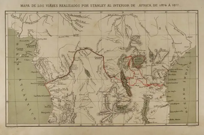
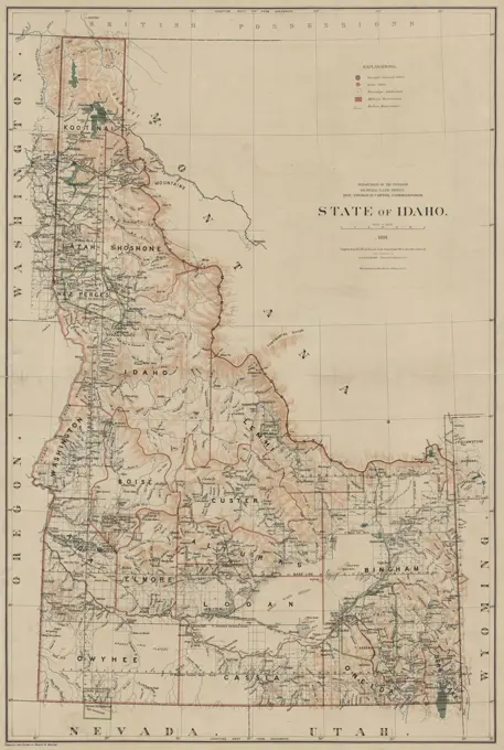
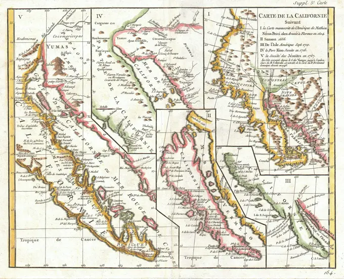
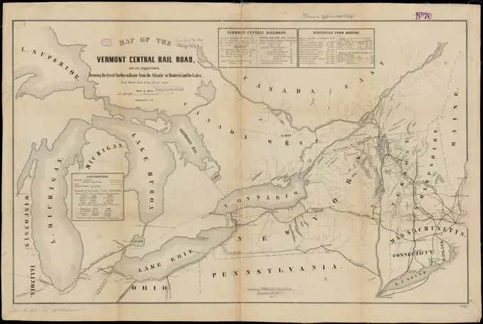
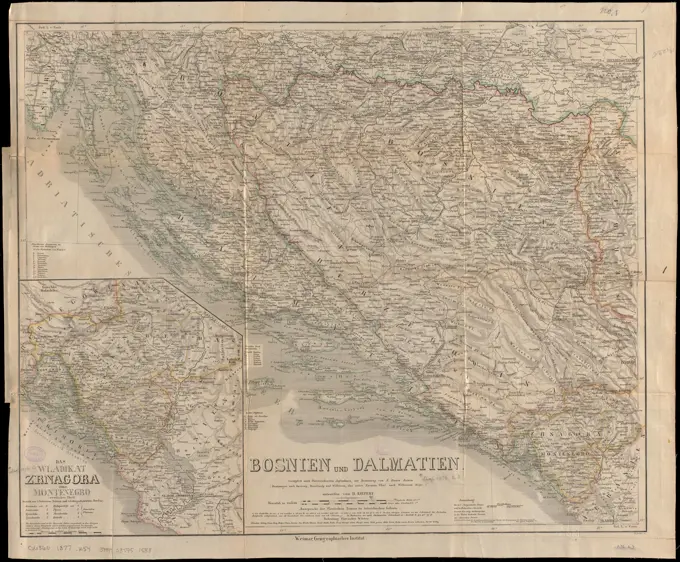
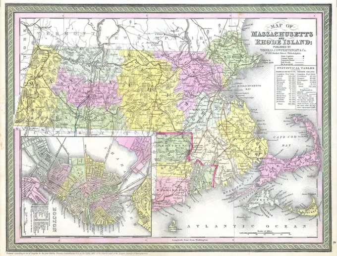
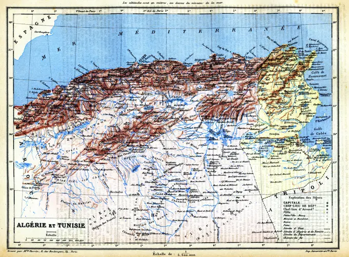
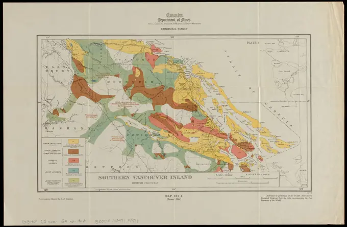
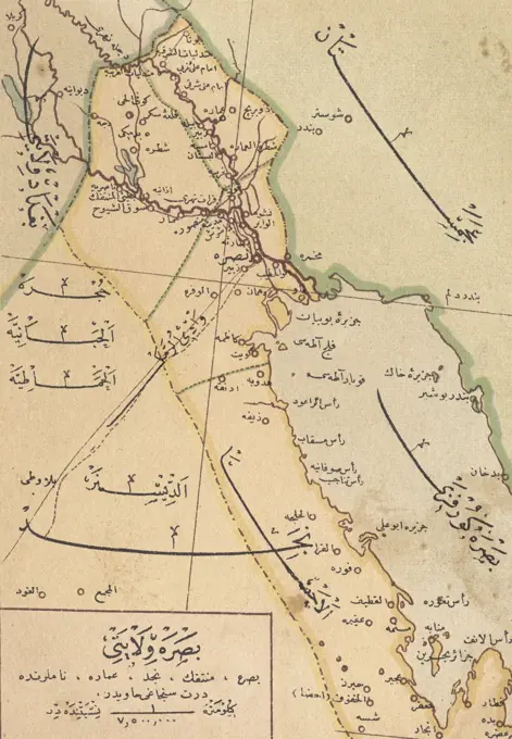
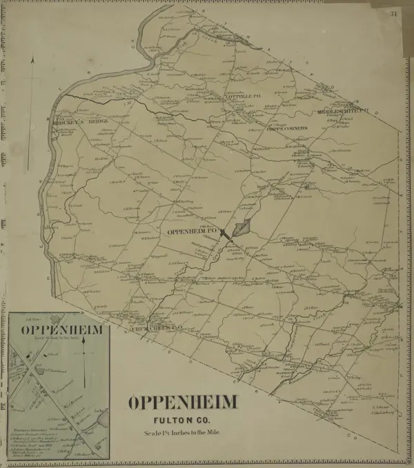
Maps detailing the Balkan region and North America, showcasing political boundaries, exploration routes, and geographical features in historical contexts.

Partie du Ct. Sentis et Autriche anterieure, 1802., 1802., Arau sic, Switzerland. Maps
185 assets in this story
6145-51391970
Central Africa , Africa, Central, Maps Norman B. Leventhal Map Center Collection
6145-55912992
Central Africa.... , Central Africa  ,area
6145-54269145
Prussia. Relief shown by hachures.... , Germany Poland
6145-50527121
Wadi Sirhan AAF aeronautical chart , Aeronautics. Ralph Finos Map Collection
6145-55956098
Cornwall text. Maps, Atlases. 1793. Lionel Pincus and Princess Firyal Map Division. Geography, Great Britain
6176-66096771
Athenian Empire its greatest extent. about 450 BC. Explanations:  Pink: Members and Allied States; Yellow: Dependent and Tributary States; Tributary Districts:  I. Island District; II. Thracian District; III. Hellespontine District; IV. Ionian District;  V. Carian District
4409-17394875
Exploration and mapping of the Congo River (1874-1877). Henry Morton Stanley. He traveled central Africa exploring Lake Victoria and Lake Tanganyka navigating the Congo River. Africa inexplorada, el Continente Misterioso by Henry Morton Stanley, c. 1887.
6145-55914783
Die Balkan-Halbinsel in 4 blattern : Turkei, Rumanien, Griechenland, Serbien, Montenegro, Bulgarien. Relief shown by hachures and spot heights. Depths shown by isolines. Insets: Constantinopel -- Athen und Piraeus -- Das Nordliche Rumanien -- Strasse der Dardanellen -- Der Bosporus. From Stieler's Hand Atlas, plates 51- 54.... , Balkan Peninsula  ,area
1838-22027094
Map of Ancient Egypt, Illustration, Cyclopaedia of Universal History, Volume 1, The Ancient World, by John Clark Ridpath, the Jones Brothers Publishing Company, 1885
4443-75469859
Dominia Anglorum in America Septentrionali, 1759' by Homann Erben. The map, published in Nuremberg by Homannianos Heredes, features hand-colored depictions of New England, Acadia, Newfoundland, and Labrador. It comprises four maps on a single sheet, with dimensions of 20 x 26 cm, 25 x 19 cm, and a total sheet size of 40 x 53 cm. The NYPL copy includes a handwritten number on the verso 127
6145-59559703
Map of Amsterdam and surroundings, Johannes Condet, 1740 print   paper etching / brush maps of cities Amsterdam. Amstelveen. Muiden. Weesp. Naarden
6145-51392529
The Daily Telegraph war map of Siberia (no. 28) , World War, 1914-1918, Russia Federation, Siberia, Maps, Siberia Russia, Maps Norman B. Leventhal Map Center Collection
6145-50536500
Collins' map of the seat of war , Franco-Prussian War, 1870-1871, Maps, Europe, Maps Norman B. Leventhal Map Center Collection
6145-54267381
Collins' map of the seat of war. Relief shown by hachures. Publication information from cover.... , Europe Europe
6145-55959808
C1. Smyrna. Kiepert, Richard, 1846-1915. Cartographic. Maps. 1902 - 1916. Lionel Pincus and Princess Firyal Map Division. Turkey, Turkey, Maps
6145-55914112
Karte des nordwestlichen Kleinasien : nach eigenen aufnahmen und unveroffentlichtem material auf Heinrich Kiepert's grundlage. Relief shown by shading and spot heights. Prime meridians: Greenwich and Paris. Inset: Turkey, and comparison to Konigreich Sachsen. Accompanied by text: Blatt D. Karte des nordwestlichen Kleinasien in vier Blattern : nach eigenen aufnahmen und unveroffentlichem material auf Heinrich Kiepert's grundlage. 3 p. ; 25 cm. Sheets include assembly diagram... Karte des nordwestlichen Kleinasien in vier blattern, nach eigenen aufnahmen und unveroffentlichtem material auf Heinrich Kiepert's grundlage Karte d. nordwestl. Kleinasien. Karte des nordwestlichen Kleinasien in vier blattern, nach eigenen aufnahmen und unveroffentlichtem material auf Heinrich Kiepert's grundlage Karte d. nordwestl. Kleinasien, Turkey
4443-75469989
Map of the State of Idaho, issued in 1891 by the General Land Office. The map is in color and measures 100 x 67 cm, with a sheet size of 106 x 73 cm. It includes details related to the geography, Indians of North America, Indian reservations, and administrative and political divisions of Idaho. The lower left corner of the NYPL Map Division copy has accession number 55711 stamped
6145-55917697
Volunteer militia and eastern army guide : One hundred and fifty miles around Richmond. General map centered on Richmond, Virginia. The map is printed in blue ink. Insets: Ninety miles around Nashville, Tenn. -- Ninety miles around Harrisburg, Pa. -- Ninety miles around Vicksburg, Miss. --Ninety miles around Baton Rouge, La. -- Beaufort N.C. Charleston S.C. and surroundings -- Pittsburg PA. and surroundings.... , Virginia  , Richmond
6145-55959053
Economic and geologic map of the state of New York showing the location of its mineral deposits Cartographic. Maps, Geological maps. 1895. Lionel Pincus and Princess Firyal Map Division. Mines and mineral resources , New York (State), Geology , New York (State), New York (State)
6145-29096105
1772 Vaugondy - Diderot Map of California in five states, California as Island.
6145-55915111
Map of the Vermont Central Rail Road and its connections, forming the Great Northern Route from the Atlantic to Montreal and the Lakes : from Smith's map of the United States. Relief shown pictorially. Includes distance chart and table o.f "Commerce of the northern lakes, 1844 & 1848 between the U.S. and Canadas, from official documents."... , Northeastern United States  ,area
6176-66093753
Vintage Historical Map: Nile River Egypt Nubia and Abyssinia, by Weimar Geographische Institut 1817
6176-66097848
This geographical and historical outline maps shows Greece and the Aegean Sea area.
6145-29907526
Map to follow the operations of the seat of Paris. (IT)
6145-55957019
Übersichtskarte der Nilländer Kiepert, Heinrich, 1818-1899. 1849 - 1856. Lepsius, Richard, 1810-1884. Cartographic. Prints, Maps. General Research Division. Egypt , Antiquities, Nile River Valley
6145-50565931
Bosnien und Dalmatien : vorzüglich nach österreichischen aufnahmen, mit benutzung von a Boués reisen (Montenegro nach Iiaraczay, Kowalewsky und Wilkinson, das untere Narenta Thal nach Wilkinsons reise) , Bosnia and Herzegovina, Maps, Dalmatia Croatia, Maps Norman B. Leventhal Map Center Collection
6145-50513053
Preliminary agricultural map of Colville Region, Washington Ter. , Soils, Washington State, Colville, Maps, Colville Wash., Maps Norman B. Leventhal Map Center Collection
6176-66916946
Map of the Chinese empire, compiled from native & foreign authorities, 1847
6145-55914920
Map of the province of Nova Scotia to illustrate report by E.R. Faribault, B.A. Sc. on the "Gold fields of Nova Scotia". Shows gold-bearing series, granite, gold discoveries, geological sheet coverage, gold district plan coverage, serial numbers and catalogue numbers. Inset: Cape Breton Island. "Compiled from original published and unpublished map sheets of the Geological Survey and other sources of information."... , Canada  , Nova Scotia  ,province
6145-50530551
Balloon view, Cape Ann to Boston , Capes Coasts, Massachusetts, Aerial views, Ann, Cape Mass., Aerial views, Boston Mass., Aerial views Norman B. Leventhal Map Center Collection
6145-54267968
Balloon view, Cape Ann to Boston. Bird's-eye view. Includes six insets.... , Massachusetts  , Essex  ,county   , Ann, Cape Massachusetts  , Suffolk  ,county   , Boston
6145-29096746
1850 Cowperthwait - Mitchell Map of Massachusetts and Rhode Island
6145-55913862
Guatemala, from official and other sources. Shows agriculture. Relief shown by gradient tints and spot heights... Guatemala agriculture. Guatemala agriculture, Guatemala
4443-11036
MAP OF BOUCHES DU RH¥NE, FRANCE
6145-48717969
Casablanca , Casablanca Morocco, Maps Norman B. Leventhal Map Center Collection
6145-51395310
Mapa comercial de la república de Peru , Railroads, Peru, Maps, Peru, Maps Norman B. Leventhal Map Center Collection
6145-55915212
Mapa comercial de la republica de Peru. Relief shown by shading.... , Peru
6145-50541599
European war map , Black Sea Region, Maps Norman B. Leventhal Map Center Collection
6145-46758746
Kiirunavaara.Kiruna Many Kronology.ur Carl Sahlin Mountain History Collection.
6145-54268075
Map of White Pass & Yukon Route and connections. Relief shown by spot heights. Inset: Map of Atlin Lake District / Poole Bros. Relief shown by hachures and spot heights. Scale ca. 1:650,000. "B 6044.".. Map of Alaska, Atlin and the Yukon. Map of Alaska, Atlin and the Yukon, Alaska Canada  , Yukon Territory  ,territory  Canada  , Province of British Columbia  ,province   , Atlin
6145-50552828
Map of the Jesuit missions in Huronia , Jesuits, Missions, Ontario, Simcoe County, Maps, Wyandot Indians, Ontario, Simcoe County, Maps, Indians of North America, Ontario, Simcoe County, Maps, Simcoe Ont. : County, Maps Norman B. Leventhal Map Center Collection
4443-17888
Map, South America, 1869
6145-51397518
Nicaragua , Transportation, Nicaragua, Maps, Nicaragua, Maps, Nicaragua, Administrative and political divisions, Maps Norman B. Leventhal Map Center Collection
6145-43861033
Sydney coal field , Coal, Nova Scotia, Sydney, Maps, Sydney N.S., Maps Norman B. Leventhal Map Center Collection
6145-50446643
N.N., North Sea Canal at Amsterdam. (From: Atlas to the magazine for Building, ed. V. G. Erbkam, born 22, 1872.) (1872-1872): Print colored on paper, 43.5 x 58.8 cm (including scan edges) N.N. : Nordseekanal bei Amsterdam. (Aus: Atlas zur Zeitschrift für Bauwesen, hrsg. v. G. Erbkam, Jg. 22, 1872)
1848-54752955
Historical map of Naples and surroundings, Italy, 19th Century, from Meyers Konversations-Lexikon encyclopaedia, 1889, Europe
6145-48718798
Map of the Mexican National Railway : showing also its relative position to the railway system of the United States, both as to the eastern & western halves of the continent , Mexican National Railway Company of Mexico, Maps, Railroads, Mexico, Maps, Railroads, United States, Maps, Mexico, Maps, United States, Maps Norman B. Leventhal Map Center Collection
6145-51392816
Egypt and the basin of the Nile , Egypt, Maps Norman B. Leventhal Map Center Collection
6145-55913576
Egypt and the basin of the Nile. Relief shown by hachures. Contains inset of the Nile Delta. On two sheets. With (on verso): Johnston's Geographical Handbooks: Egypt. MB (BRL)... , Egypt
6145-51393238
Geologische karte von Deutschland , Geology, Germany, Maps Norman B. Leventhal Map Center Collection
6145-50520767
State of Chiapas , Chiapas Mexico, Maps Norman B. Leventhal Map Center Collection
6145-51387234
Russisch-Türkischer Kriegsschauplatz, 1877 , Turkey, Maps Norman B. Leventhal Map Center Collection
6145-55916994
Russisch-Turkischer Kriegsschauplatz, 1877. Relief shown by hachures and spot heights. Prime meridian: Paris. Inset map: Die Dobrudscha.... , Turkey
6145-29095889
Ecuador and Peru detail, 1864 Mitchell Map of Peru, Equador (Ecuador), Argentina, Columbia and Venezuela
4409-20890919
España. Mapa de El Rif, con los límites de las colonias españolas en el norte de África en los años 1920.
6145-46757665
Höganäs coal grapes chronology.ur Carl Sahlin mountain historical collection.
6145-51396384
Egypt and the basin of the Nile , Egypt, Maps Norman B. Leventhal Map Center Collection
6176-61905112
Image taken from page 169 of 'Au Canada et chez les Peaux-Rouges. Ouvrage contenant neuf gravures hors texte, d'après les dessins de G. Tiret-Bognet et L. Boudier et une carte, etc'
6145-48718032
State of West Virginia and part of Maryland : coal fields and producing districts , Coal mines and mining, West Virginia, Maps, Coal mines and mining, Maryland, Maps, Maryland, Maps, West Virginia, Maps Norman B. Leventhal Map Center Collection
6145-55167300
Adriatic... Adriatic Sea region. Adriatic Sea region, Adriatic Sea
6145-50568138
A geological map of the Black Hills , Geology, Black Hills S.D. and Wyo., Maps, Black Hills S.D. and Wyo., Maps Norman B. Leventhal Map Center Collection
6188-55550135
The map of Algeria and Tunisia The map of Algeria and Tunisia with names of their cities on it. Copyright: xZoonar.com/PatrickxGuenettex 10647555
6145-50565766
The British and Russian frontiers in Central Asia , Asia, Central, Maps, Great Britain, Colonies, Asia, Maps Norman B. Leventhal Map Center Collection
1848-20129221
Map with elevation data from Germany, 1880, digitally restored reproduction of an original 19th century template, exact original date unknown
6145-59102766
Sclavonia, Croatia, Bosnia Cum Dalmariae Parte; Schenck, Pieter (1660-1711), Valck, Gerard (1651 cars 1652-1726); 1711 (1711-00-00-1711-00-00);
6145-51387565
Das Siebengebirge , Geology, Germany, Siebengebirge, Maps, Siebengebirge Germany, Maps Norman B. Leventhal Map Center Collection
6176-67043841
''Relief Map of Algerie', 1914. From "Grande Geographie Bong Illustree", 1914.
6145-43861069
Southern Vancouver Island, British Columbia , Geology, British Columbia, Vancouver Island, Maps, Vancouver Island B.C., Maps Norman B. Leventhal Map Center Collection
6145-55917543
Carta geral do estado de S. Paulo : com indicacoes sobre agricultura, comercio, instruccao publica, industria e colonisacao. Prime meridian: Rio de Janeiro. Includes altitude and distance table, statistics and graph showing coffee production.... , Brazil  , Estado de São Paulo
6145-46767943
Swedish mountain people travel in foreign.
6145-48642169
Camarines Sur : (western part) , Camarines Sur Philippines, Maps Norman B. Leventhal Map Center Collection
4220-21842631
Siberia and Eastern Russia          Date: circa 1860
6145-54549095
Amherst Township Cartographic. Atlases, Maps. 1866. Lionel Pincus and Princess Firyal Map Division. Erie County (N.Y.)
6145-52359086
Map showing the distribution of the Trapogans Beebe, William (1877-1962). Cartographic. Maps. 1918 - 1922. General Research Division. Pheasants
6145-55913905
Le Havre agrandissement du port : plan des travaux projetes. Relief shown by hachures. "Supplement au journal Le Temps du Mardi 29 Mai 1888."... , France  , Normandie  ,region   , Le Havre
6145-50534346
Carta corografica del Distrito Federal , Distrito Federal Mexico, Maps Norman B. Leventhal Map Center Collection
6145-54269439
Carta corografica del Distrito Federal. Relief shown by hachures. Prime meridian: Mexico City. Includes statistics, topographic map, political map, census figures and table of abbreviations. "2a. serie, no. 19."... , Mexico  , Distrito Federal  ,territory
6145-29210672
Peru from Court Game of Geography 1838-55 William and Henry Rock. Peru from Court Game of Geography. 1838-55. Engraving and hand coloring (watercolor). William and Henry Rock
4220-20417006
Ottoman Turkish Map of the southern province of Iraq and the territory which is now Kuwait, The area depicted focusses on Basra and the Shatt al-Arab region leading out into the Persian Gulf (lower right hand section of the map)     Date: circa 1907
6145-50552752
Map of Syria in the IV-V-VI centuries , Syria, Historical geography, Maps, Syria, History, 333 B.C.-634 A.D, Maps, Syria, Maps Norman B. Leventhal Map Center Collection
6145-55166984
The counties of Southern California. Relief shown by hachures and spot heights.... , California  , Los Angeles  ,county  California  , Riverside  ,county  California  , San Bernardino  ,county  California  , San Diego  ,county  California  , Santa Barbara  ,county  California  , Ventura  ,county
4443-75470143
Oppenheim Fulton Co. Township; Oppenheim Village; Oppenheim Business Directory, 1868., 1868., New York. Publisher, Stranahan & Nichols. Real property, New York (State), Montgomery County; Fulton County (N.Y.)
6145-51395312
Mapa comercial de la República de Colombia , Railroads, Colombia, Maps, Railroads, Panama, Maps, Colombia, Maps Norman B. Leventhal Map Center Collection
6145-51396565
Latii veteris et finitarum regionum , Lazio Italy, Antiquities, Lazio Italy, Historical geography, Maps Norman B. Leventhal Map Center Collection
4443-75464898
A map of Russia by Gerbershtein, covered with forests, from the Latin edition of 'Notes about Moscovia,' Basel, 1556. Additional details include the text on page 8 of the publication by Tip. S.V. Kulʹzhenko, issued in 1899, reflecting cartography and the historical context of Russia
PREVIOUS
of 2
NEXT
2401 S. Ervay, Suite 206
Dallas, Texas 75215
United States
Get Started
Free ResearchMy BoardsMy Cart
For Creators
How To License Your ContentContributor PortalFrame of Mind
Resources
API accessPricing
Contact
+1 866 236 0087help@viewpictures.co.uk Contact form
©2026 View Pictures. All Rights Reserved. -B
This site is protected by reCAPTCHA and Google Privacy Policy and Terms of Service apply.