My Boards
View Pictures
  • My Boards

Mars Craters and Channels

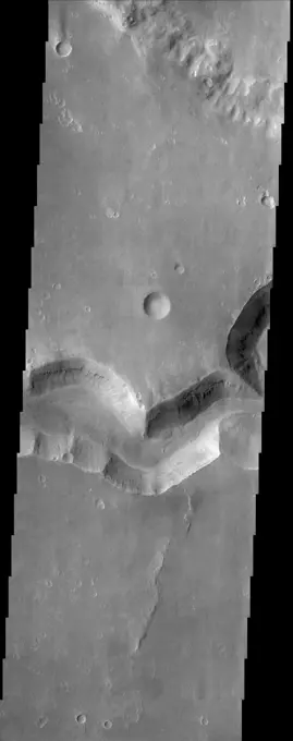
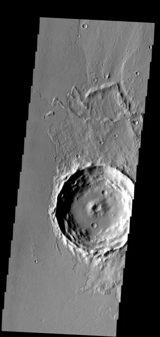
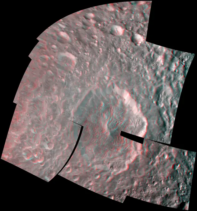
Various Martian landscapes featuring craters, channels, and gullies, showcasing topographical details captured by NASA's 2001 Odyssey spacecraft.

The channel in today's VIS image is called Auqakuh Vallis. Large channels on Mars are named for the word mars/star in different languages on Earth, small channels are named for rivers on Earth. Auqakuh is the word mars in Quechua (Inca). Orbit Number 79261 Latitude 29.0373 Longitude 60.3106 Instrument VIS Captured 2019-10-27 16 12
463 assets in this story
6145-44933142
This image captured by NASA's 2001 Mars Odyssey spacecraft shows the western margin of Juventae Chasma and the dunes that occur at the base of the chasma cliff.
6145-44746068
Lava Channels
6145-45013942
I Melt With You
6145-44565857
Mars Orbiter Camera Views the Face
6145-44899540
This unnamed channel is located in Arabia Terra as seen by NASA's 2001 Mars Odyssey spacecraft.
6145-44668151
Portion of Isidis Planitia Near the Beagle 2 Landing Ellipse
6145-44665491
Ascraeus Mons Caldera Wall
6145-44664975
East Mareotis Tholus
6145-44643793
The gullies in this image of Gali Crater occur on the northfacing/sunfacing slope
6145-44586541
Impact craters in Hecates Tholus, as seen in this image from NASA's Mars Odyssey spacecraft, appear to be filled with sediment derived from erosion of the surrounding terrain.
6145-44759372
Dust Devil Tracks
6145-44602474
Martian Tracery
6145-44584181
The grabens (fractures) that dominate this scene from NASA's Mars Odyssey spacecraft are located northwest of a large shield volcano called Elysium Mons. Layered rock is evident along the lips of the graben as are ripples on the floors of these features.
6145-44618855
Plentiful Dust Devils
6145-44840250
A branch of Nanedi Valles entered a crater and deposited a delta that fills the majority of the crater floor. This image was captured by NASA's Mars Odyssey.
6145-44659750
This large fracture occurs on the lava flows of Ceraunius Tholus.
6145-45265916
Dark dunes fill part of the floor of this unnamed crater in Terra Sirenum. There are numerous gullies on the rim of the crater. Winds are moving the sand towards the upper left of this image, filling the lower sections of many gullies. Orbit Number 75020 Latitude -52.6235 Longitude 215.879 Instrument VIS Captured 2018-11-12 09 26
6145-44586532
This image from NASA's Mars Odyssey spacecraft shows fractures within the volcanic plains south of Elysium Mons.
6145-45299033
Located between the lava plains of Daedalia Planum and Solis Planum, Claritas Fossae is a graben filled highland. Graben are formed by tectonic activity, where extensional forces stretch the surface allowing blocks of material to slide down between paired faults. These linear grabens are termed fossae. This region of Mars had very active tectonism and volcanism, resulting in the huge volcanos like Arsia Mons and deep chasmata of Valles Marineris. Claritas Fossae was formed prior to the large lava flows of the Tharsis region. Orbit Number 81376 Latitude -35.6385 Longitude 253.121 Instrument VIS Captured 2020-04-18 15 46
6145-44575681
This image from NASA's Mars Odyssey spacecraft shows a sinuous valley network channel with sharp bends cutting across the cratered highlands of the southern hemisphere of Mars.
6145-45092049
The faint dark lines in this image captured by NASA's 2001 Mars Odyssey spacecraft are caused by dust devils. As the dust devil travels along the surface it scours away the loose surface dust, revealing the darker surface beneath.
6145-44845780
Dune fields are common in the topographic lows in the Aonia Planum and Aonia Terra region as captured by NASA's Mars Odyssey.
6145-44586271
This image from NASA's Mars Odyssey spacecraft of the northern plains of Mars shows a surface texture of hundreds of small mounds and numerous small impact craters.
6145-44533334
Today's VIS image shows part of Claritas Fossae. These graben filled highlands are bounded by Solis Planum to the northeast and Icaria Planum to the southwest. The linear features (fossae) are graben, a tectonic feature created when blocks of material subside between paired faults. Extensional tectonic forces are responsible for graben formation. While close to the Tharsis region, it is thought that Claritas Fossae formed prior to the large lava flows located north of this image. Orbit Number 83503 Latitude -40.434 Longitude 274.364 Instrument VIS Captured 2020-10-10 22 06
6145-44666545
Gullies on the Exterior Wall of a Crater
6145-44625398
Alba Patera Collapse Pits
6145-45264054
This image of landslides along Ceres' Occator Crater's eastern rim was obtained by NASA's Dawn spacecraft on June 9, 2018 from an altitude of about 27 miles (44 kilometers).
6145-44661498
The material covering the floors of these two craters looks very different from the surrounds. The unusual markings of the floor material indicates that a volatile, such as ice, has affected the appearance of the surface
6145-44886537
These windstreaks, located north of Olympus Mons, indicate winds from the south-southeast. This image is from NASA's 2001 Mars Odyssey spacecraft.
6145-45264594
There are several different surface textures in the South Polar ice. The surface in this image with the round/semi round depressions is informally called swiss cheese. Orbit Number 74312 Latitude -86.9779 Longitude 29.0233 Instrument VIS Captured 2018-09-15 02 05
6145-44818905
This image from NASA's 2001 Mars Odyssey of central Utopia Planitia shows some dust devil tracks. These features are common in this region of Mars.
6145-45260930
This image shows part smaller summit caldera of Pavonis Mons. This caldera is approximately 5km deep. Near the bottom of the image is a region where part of the caldera side has collapsed into the bottom of the caldera. In shield volcanoes calderas are typically formed where the surface collapses into the void formed by an emptied magma chamber. Pavonis Mons is one of the three aligned Tharsis Volcanoes. The four Tharsis volcanoes are Ascreaus Mons, Pavonis Mons, Arsia Mons, and Olympus Mars. All four are shield type volcanoes. Shield volcanoes are formed by lava flows originating near or at the summit, building up layers upon layers of lava. The Hawaiian islands on Earth are shield volcanoes. The three aligned volcanoes are located along a topographic rise in the Tharsis region. Along this trend there are increased tectonic features and additional lava flows. Pavonis Mons is the smallest of the four volcanoes, rising 14km above the mean Mars surface level with a width of 375km. It has
6145-44669433
Yardangs within a Large Crater
6145-44711370
THEMIS ART #86
6145-45004392
The dark markings in this image from NASA's 2001 Mars Odyssey spacecraft are tracks made by the passage of 'dust devils.' Dust devils are common in the extensive plains of the northern latitudes. This image is located in Utopia Planitia.
6145-44988896
The channels in this image captured by NASA's 2001 Mars Odyssey spacecraft are located in Elysium Planitia and were likely created by lava flow.
6145-45261480
This image shows part of the western flank of Pavonis Mons. The linear features are faults. Faulting usually includes change of elevation, where blocks of material slide down the fault. Paired faults are call graben. The large depression is a graben, whereas most of the other faults are not paired. The rougher looking materials perpendicular to the faults are lava flows. Down hill is to the upper left corner of the image. Pavonis Mons is one of the three aligned Tharsis Volcanoes. The four Tharsis volcanoes are Ascreaus Mons, Pavonis Mons, Arsia Mons, and Olympus Mars. All four are shield type volcanoes. Shield volcanoes are formed by lava flows originating near or at the summit, building up layers upon layers of lava. The Hawaiian islands on Earth are shield volcanoes. The three aligned volcanoes are located along a topographic rise in the Tharsis region. Along this trend there are increased tectonic features and additional lava flows. Pavonis Mons is the smallest of the four volcanoe
6145-45049958
A long, narrow windstreak has formed in the lee of this hill in the Tartarus Montes. Several small dark craters also have windstreaks as shown by NASA's 2001 Mars Odyssey spacecraft.
6145-45086725
This image from NASA's Mars Mars Reconnaissance Orbiter shows a triple impact crater in Elysium Planitia near Tartarus Montes, which probably formed when a binary-or even triple-asteroid struck the surface.
6145-44579143
Hrad Valles, seen in this image from NASA's Mars Odyssey spacecraft, is located north-northwest of the large Elysium Mons volcanic complex and is yet another example of a channel that likely carried fluids.
6145-44592648
This image from NASA's Mars Odyssey spacecraft shows the Olympica Fossae channel system located east of the Olympus Mons volcano in Tharsis. These anastomosing channels cut numerous lava flows indicating that the channels are younger than the lava flows.
6145-44664959
Mawrth Vallis Layered Deposits
6145-44644879
This channel and its tributaries are a part of Nanedi Vallis
6145-44647694
Located on the eastern edge of the Tharsis region, this crater has had half of its ejecta covered by lava flows
6145-44818109
This image from NASA's Mars Reconnaissance Orbiter covers a small portion of the northwest quadrant of Hellas Basin, or Hellas Planitia, on southern Mars; Hellas is one of the largest impact craters in the solar system.
6145-44667340
Evidence of Multiple Episodes of Gully Formation
6145-44662588
Ius Chasma Tributary Valleys and Adjacent Plains
6145-58971973
This VIS image is located in the central portion of Hephaestus Fossae. Hephaestus Fossae is a complex channel system in Utopia Planitia near Elysium Mons. It has been proposed that the channel formed by the release of melted subsurface ice during the impact event that created the crater in this image. Additionally, the nearby Elysium volcanic center created subsurface heating that may have played a part in creating both Hephaestus Fossae and Hebrus Valles to the north. Orbit Number 81193 Latitude 18.8168 Longitude 124.985 Instrument VIS Captured 2020-04-03 18 04
6145-45092026
The THEMIS VIS camera contains 5 filters. The data from different filters can be combined in multiple ways to create a false color image. This false color image from NASA's 2001 Mars Odyssey spacecraft shows part of the floor of Muller Crater.
6145-44637649
This VIS image from NASA's 2001 Mars Odyssey spacecraft shows part of the floor of an unnamed crater located between the Hellas and Argyre Basins.
6145-44611482
Typical Crater
6145-44630866
Rejoining Flows
6145-52960777
. Labeatis Fossae. The linear feature in this VIS image is part of Labeatis Fossae. Fossae are linear depressions, most often caused by extensional tectonic forces pulling the crust apart and allowing material to slide downward between bounding faults. In regions of volcanic flows, the depression may be caused by roof collapse into an underlying void left by a lava tube. As this feature is located in the Tharsis volcanic region, it is likely that this feature was primarily created by volcanic collapse rather tectonic stress. Orbit Number 94403 Latitude 22.828 Longitude 266.725 Instrument VIS Captured 2023-03-27 10 51
6145-44958099
Moving eastward across the southern part of Gale Crater, this image from NASA's Mars Odyssey spacecraft shows more dark material deposited from the large channel through the SW rim of crater; material has a sharp edge where it overlays the crater floor.
6145-44620744
Acheron Catena
6145-44484416
Today's VIS image shows part of the summit caldera of Olympus Mons. Scarps and extensional features (graben) record multiple stages of caldera collapse at the summit of Olympus Mons. Olympus Mons is the largest volcano in the solar system, reaching heights over 40 km (25 miles) tall from base to summit, with the base covering an area as large as the state of Arizona. For comparison, Mauna Loa is 9 km (5.5 miles) tall measured from its base on the sea floor. Orbit Number 87666 Latitude 18.7403 Longitude 226.733 Instrument VIS Captured 2021-09-18 17 27
6145-45263295
Scientists created this stereo view, called an anaglyph, with two images of the same part of Ceres's surface taken by Dawn on different orbits and from different viewing angles. The images were artificially colored and combined so that when viewed through glasses with a red filter on the left and blue on the right, they provide a 3-D view. The images used for this anaglyph were obtained by NASA's Dawn spacecraft from an altitude of about 21 miles (34 kilometers). The center of this image is located at about 19.6 degrees north latitude and 239.5 degrees east longitude.
6145-44842319
Wispy fractures cut through cratered terrain on Saturn's moon Rhea in this high resolution, 3-D image from NASA's Cassini spacecraft. 3D glasses are necessary to identify surface detail.
6145-44810529
NASA's Cassini spacecraft captured a three-dimensional view of the large Herschel Crater on Saturn's moon Mimas during its closest-ever flyby of the moon. 3D glasses are needed to view this image.
6145-44674853
Signs of Fluids and Ice in Acidalia Planitia
6145-44587328
The relatively flat floor and terrace walls of this impact crater imaged by NASA's Mars Odyssey spacecraft suggest the crater was partly infilled with sediment and subsequently eroded to its present day form.
6145-44903712
The channel in this image from NASA's 2001 Mars Odyssey spacecraft is part of Hebrus Vallis, located on the western margin of the Elysium volcanic complex.
6145-44618886
Looking into London
PREVIOUS
of 5
NEXT
2401 S. Ervay, Suite 206
Dallas, Texas 75215
United States
Get Started
Free ResearchMy BoardsMy Cart
For Creators
How To License Your ContentContributor PortalFrame of Mind
Resources
API accessPricing
Contact
+1 866 236 0087help@viewpictures.co.uk Contact form
©2026 View Pictures. All Rights Reserved. -A
This site is protected by reCAPTCHA and Google Privacy Policy and Terms of Service apply.