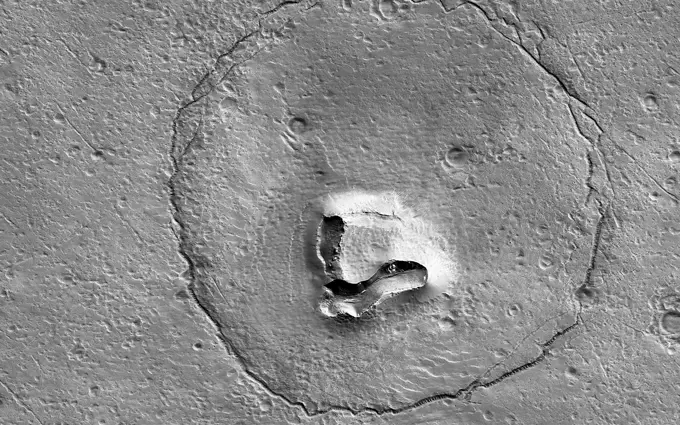
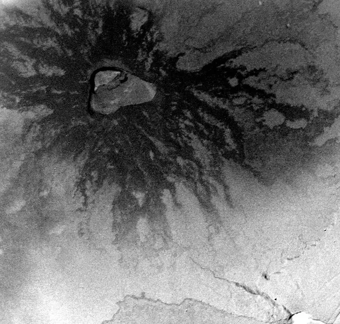
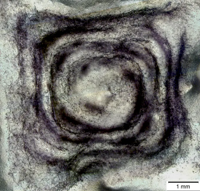
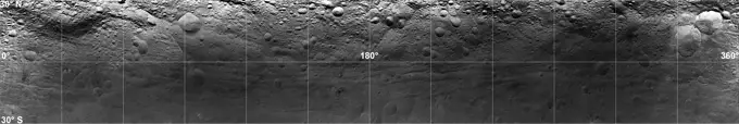
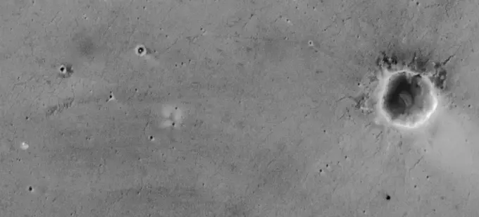
My Boards
View Pictures
  • My Boards

Mars Geological Features

A collection of grey-scale images showcasing Martian landscapes, including lava tubes, craters, and dunes, revealing diverse geological processes.

Venus - Comparison of Venera and Magellan Resolutions
283 assets in this story
6145-44609415
Focus on El Capitan
6145-44597709
Volcanic Surface Textures
6145-44880764
Deep Impact
6145-45260162
This image captured by NASA's 2001 Mars Odyssey spacecraft resembles a face staring back at the spacecraft. Orbit Number 65345 Latitude 34.4675 Longitude 105.179 Instrument IR Captured 2016-09-06 09 27
6145-44604371
Olympica Fossae
6145-44615247
Martian Brain
6145-44562311
Jupiter's atmospheric circulation is dominated by alternating eastward and westward jets from equatorial to polar latitudes. This image was taken on April 3, 1997, by NASA's Galileo spacecraft.
6145-45125958
NASA's Cassini image features a density wave in Saturn's A ring (at left) that lies around 134,500 km from Saturn. Density waves are accumulations of particles at certain distances from the planet.
6145-44511925
This stereo image mosaic from NASA's Mars Global Surveyor is of Mars' south polar terrain. 3D glasses are necessary to view this image.
6145-44656380
This MOC image shows crescent-shaped, scooped-out hollows where wind has eroded the local bedrock in the Apollinaris Sulci region
6145-45192557
Research using data from NASA's ARTEMIS mission suggests that lunar swirls, like the Reiner Gamma lunar swirl imaged here by NASA's Lunar Reconnaissance Orbiter, could be the result of solar wind interactions with the Moon's isolated pockets of magnetic field.
6145-44628262
THEMIS Images as Art #38
6145-44648188
This MOC image shows windblown ripples on the floor of Auqakuh Vallis. The light-toned area, running diagonally across the scene from the lower left to the upper right, may be dust that has accumulated in the bottom of the valley and on top of the ripples
6145-44601698
Public-Requested Mars Image: Crater on Pavonis Mons
6145-58967220
NASA's Dawn spacecraft obtained this false-color image (right) of an impact crater in asteroid Vesta's equatorial region with its framing camera on July 25, 2011. The view on the left is from the camera's clear filter.
1746-19671051
This Magellan image is centered in the northeastern Atalanta Region of Venus.
6145-45265645
Europa's surface is covered with a vast network of linear features such as cracks, ridges, and bands, as well as other smaller circular features that include pits, spots, domes, and microchaos. This image, created from clear-filter images taken on the Galileo spacecraft's 17th orbit around Jupiter and colorized with lower-resolution images taken on Galileo's first orbit around Jupiter (link to
4389-593
3-D Image of Enceladus' Craters
6145-44913455
The Chemistry and Camera (ChemCam) instrument on NASA's Mars rover Curiosity used its laser and spectrometers to examine what chemical elements are in a drift of Martian sand during the mission's 74th Martian day, or sol (Oct. 20, 2012).
6145-44807649
NASA's Mars Reconnaissance Orbiter has detected widespread deposits of glacial ice in the mid-latitudes of Mars. This map of a region known as Deuteronilus Mensae, in the northern hemisphere, shows locations of the detected ice deposits in blue.
6145-44783958
These two images, taken four years before Saturns August 2009 equinox by NASA's Cassini spacecraft, indicate the streaks in these images are likely evidence of impacts into the planets rings.
6145-44624056
Spirit's View of 'Columbia Hills' (polar)
6145-45256883
. Peeking Into Lunar Pits
6145-44756806
AS08-12-2193 (21-27 Dec. 1968) --- View of the lunar surface taken from the Apollo 8 spacecraft looking southward from high altitude across the Southern Sea. (Hold picture with AS8 number in upper right corner). The bright-rayed crater near the horizon is located near 130 degrees east longitude and 70 degrees south latitude. The dark-floored crater near the middle of the right side of the photograph is about 70 kilometers (45 statute miles) in diameter. Both features are beyond the eastern limb of the moon as viewed from Earth; neither has a name.
6145-44853182
Buckland Boulders
6145-44554449
Many prominent rocks near the Sagan Memorial Station are featured in this image, from NASA's Mars Pathfinder. 'Shark', 'Half-Dome', and 'Pumpkin', 'Flat Top' and 'Frog' are at center 3D glasses are necessary to identify surface detail.
824-57657958
Sappinia is an amoeba (a single-celled living organism), found in the environment. There are two known species of Sappinia: Sappinia diploidea and Sappinia pedata. This amoeba causes amoebic encephalitis, which is an infection of the brain. Worldwide, only one case of amoebic encephalitis due to Sappinia infection has been reported.
6121-28634119
Baseball laying with home plate on dirt field for game in black and white.
6145-44562307
Europa Ice Rafts
6145-45247714
This image is illuminated by sunlight from the upper left. Looking like pieces of sliced and broken swiss cheese, the upper layer of the martian south polar residual cap has been eroded, leaving flat-topped mesas into which are set circular depressions such as those shown here. The circular features are depressions, not hills. The largest mesas here stand about 4 meters (13 feet) high and may be composed of frozen carbon dioxide and/or water. Nothing like this has ever been seen anywhere on Mars except within the south polar cap, leading to some speculation that these landforms may have something to do with the carbon dioxide thought to be frozen in the south polar region. On Earth, we know frozen carbon dioxide as dry ice. On Mars, as this picture might be suggesting, there may be entire landforms larger than a small town and taller than 2 to 3 men and women that consist, in part, of dry ice. No one knows for certain whether frozen carbon dioxide has played a role in the creation of t
6145-44663106
North Polar Permanent Cap Crater
6145-44620490
This view from the microscopic imager on NASA's Mars Exploration Rover Opportunity shows a type of light-colored, rough-textured spherules scientists call 'popcorn' in contrast to the darker, smoother spherules called 'blueberries.'
6145-45121003
This area of Amazonis Planitia to the west of the large volcano Olympus Mons was once flooded with lava as seen by NASA's Mars Reconnaissance Orbiter. A huge eruption flowed out across the relatively flat landscape.
6145-45115244
This synthetic-aperture radar (SAR) image was obtained by NASA's Cassini spacecraft on July 25, 2016, during its 'T-121' pass over Titan's southern latitudes. The image shows an area nicknamed the 'Xanadu annex' by members of the Cassini radar team.
6145-45110319
NASA's Terra spacecraft reveals signs of life in New Zealand's Mount Ruapehu Volcano which has been on a level 1 volcanic alert for some time, indicating minor volcanic unrest.
6145-44631643
Waves on Saturn
6145-44990642
This image acquired by NASA's Terra spacecraft is of Mount Etna, on the Italian island of Sicily, Europe's most active volcano, where its latest series of eruptions has continued for weeks.
6145-45101281
This montage of images from NASA's Cassini orbiter shows the precise location of the north pole on Saturn's icy moon Enceladus.
6145-45100521
This highest-resolution image from NASA's New Horizons spacecraft reveals new details of Pluto's rugged, icy cratered plains.
6145-45251043
This Mars Global Surveyor (MGS) Mars Orbiter Camera (MOC) image of dunes in the martian north polar region is important because it shows one of the highest northern latitude views of streaks thought to be made by passing dust devils. The dark, thin, filamentary streaks on the dunes and on the adjacent plains were probably formed by dust devils. The dunes occur near 76.6°N, 62.7°W. Dust devil streaks are observed on Mars at very high latitudes, such as this, all the way down to the equator. They are also seen at all elevations, from the deepest parts of the Hellas Basin to the summit of Olympus Mons. This picture covers an area about 3 km (1.9 mi) wide. Sunlight illuminates the scene from the lower left. http //photojournal.jpl.nasa.gov/catalog/PIA06334
6145-44507837
This anaglyph, from NASA's Shuttle Radar Topography Mission, shows Meseta de Somuncura, a broad plateau capped by basalt. Near its western edge is evidence of multiple volcanic events. 3D glasses are necessary to view this image.
6145-45261992
Siton Undae is a large dune field located in the northern plains near Escorial Crater. Siton Undae is west of the crater and is one of three dune fields near the crater. The nearby north polar cap is dissected by Chasma Boreale, which exposes an ice free surface. This image shows part of the southern extent of the dune field. The Odyssey spacecraft has spent over 15 years in orbit around Mars, circling the planet more than 69000 times. It holds the record for longest working spacecraft at Mars. THEMIS, the IR/VIS camera system, has collected data for the entire mission and provides images covering all seasons and lighting conditions. Over the years many features of interest have received repeated imaging, building up a suite of images covering the entire feature. From the deepest chasma to the tallest volcano, individual dunes inside craters and dune fields that encircle the north pole, channels carved by water and lava, and a variety of other feature, THEMIS has imaged them all. For t
6145-44619355
Spirit's Course
6145-44562290
This mosaic shows the features of a hazy cloud layer tens of kilometers above Jupiter's main visible cloud deck as seen by NASA's Galileo orbiter on February 19, 1997.
6145-44693100
CRISM's Global Mapping of Mars, Part 1
6145-44483092
These images and animation represent NASA radar observations of 4660 Nereus on Dec. 10, 2021, before the asteroid's close approach on Dec. 11, when it came within 2.5 million miles (4 million kilometers) of Earth. Using the 70-meter radio antenna at the Deep Space Network's Goldstone Deep Space Communications Complex near Barstow, California, scientists from NASA's Jet Propulsion Laboratory acquired the most detailed radar images of the nearly 1,100-foot-wide (330-meter-wide) near-Earth asteroid since its discovery almost four decades earlier. Nereus' orbit is very well known and the asteroid does not pose a threat to Earth. During the asteroid's close approach, an image resolution of about 12.3 feet (3.75 meters) per pixel was possible, revealing surface features such as potential boulders and craters, plus ridges and other topography. Asteroid Nereus' previous approach in 2002 was near enough to Earth to reveal the asteroid's size and overall shape, but too distant to show surface fe
6145-44635565
A Great Place to Watch the Weather (polar)
6145-44554453
This area of terrain near the Sagan Memorial Station was taken by NASA's Mars Pathfinder. 3D glasses are necessary to identify surface detail.
6145-52930771
A Bear on Mars. This feature looks a bit like a bear's face. What is it really There's a hill with a V-shaped collapse structure (the nose), two craters (the eyes), and a circular fracture pattern (the head). The circular fracture pattern might be due to the settling of a deposit over a buried impact crater. Maybe the nose is a volcanic or mud vent and the deposit could be lava or mud flows Maybe just grin and bear it. https //photojournal.jpl.nasa.gov/catalog/PIA25709
6145-44562046
Four Galileo Views of Amalthea
6145-44961249
This mosaic shot by the microscopic imager on the robotic arm of NASA's Mars Exploration Rover Opportunity shows a rock target called 'Esperance' after some of the rock's surface had been removed by Opportunity's rock abrasion tool.
6145-44702737
Two Radar Sounders Examine South Polar Layered Deposits on Mars
6145-44607273
Mars Exploration Rover (MER-B) Opportunity Landing Site
6145-45050523
This feature from NASA's Mars Reconnaissance Orbiter looks like a heart. It is located south of Ascraeus Mons, which is a large volcano within the Tharsis volcanic plateau, making it extremely likely that this feature was formed by a volcanic process.
6145-44881308
This image, made from data obtained by NASA's Dawn spacecraft, shows a perspective view of a layered young crater in the Rheasilvia basin at asteroid Vesta.
6145-44629298
Stressed-out Enceladus
6145-44596081
Two Mars Years of South Polar Change
6145-44505860
Io
824-63162830
Bioprinting, an artificial fabrication of biological tissues allowing regenerative medicine, dark purple dots are viable cells and able to survive in the model.
6145-44622593
Opportunity's Travels During its First 205 Martian Days
6145-44756008
Titan's Sand
6145-44611484
A Double Take at Serpent Drift
6145-45103462
Looking east to west across the rim and down into Chaplygin crater reveals this beautiful example of a fresh young crater and its perfectly preserved ejecta blanket. The delicate patterns of flow across, over, and down local topography clearly show that ejecta traveled as a ground hugging flow for great distances, rather than simply being tossed out on a ballistic trajectory. Very near the rim lies a dark, lacy, discontinuous crust of now frozen impact melt. Clearly this dark material is on top of the bright material so it was the very last material ejected from the crater. The melt was formed as the tremendous energy of impact was converted to heat and the lunar crust was melted at the impact point. As the crater rebounded and material sloughed down the walls of the deforming crater the melt was splashed out over the rim and froze. Its low reflectance is mostly due to a high percentage of glass because the melt cooled so quickly that minerals did not have time to crystallize. The fact
6145-44575103
Large Brown Spot in Saturn's Atmosphere
6145-44565855
On its 256th orbit of Mars, the camera on-board NASA's Mars Global Surveyor spacecraft successfully observed the vicinity of the Mars Pathfinder landing site. 3D glasses are necessary to identify surface detail.
6145-44876234
This image is a mosaic of Vesta's equatorial region, composed of observations taken through the panchromatic filter on the framing camera onboard NASA's Dawn spacecraft on July 24, 2011.
6145-44626696
Nope, Not Jupiter!
6145-44638514
A Closer Look at 'Kalavrita'
6145-42597807
Royal Air Force Maintenance Command, 1939-1945. Oblique aerial view of the crater caused by the detonation of 3,500 tons of high explosive in the New High Explosive Bomb Area at No. 21 Maintenance Unit at Fauld, near Hanbury, Staffordshire, at 11.11 am on 27 November 1944. RAF Fauld, situated in a former gypsum mine, was the main repository of HE ordnance in the country. The explosion, calculated at some 4 kilotonnes, constitutes the world's largest non-nuclear explosion. 23 workers at the site, both RAF personnel and Italian prisoners of war, were killed, as were 41 workers at a nearby plaster works, and a number of local inhabitants. The view is from the west, with Stonepit Hills and the RAF camp visible at the top.
6145-44627723
Opportunity Tracks Seen from Orbit
6145-44548435
This image covers much of Ovda Regio, which forms the western part of Aphrodite Terra captured by NASA's Magellan spacecraft.
6145-44656388
Shadows Draw Attention to Features of Mars Landscape (Sand Ripples)
6145-44661537
Looking Saturn in the Eye
6145-44562032
Thera and Thrace Macula on Europa
6145-44575152
This is a false-color L-band image of an area near Glasgow, Missouri, centered at about 39.2 degrees north latitude and 92.8 degrees west longitude.
6145-44505063
Mars Polar Lander: The Search Begins
6145-44899810
NASA's Curiosity rover and its parachute were spotted by NASA's Mars Reconnaissance Orbiter as Curiosity descended to the surface. The HiRISE camera captured this image of Curiosity while the orbiter was listening to transmissions from the rover.
1525-20849664
Lunar Surface
6145-44608408
This 3-D anaglyph, from NASA's Mars Exploration Rover Spirit, shows an extreme close-up of round, blueberry-shaped grains on the crater floor near the rock outcrop at Meridiani Planum called Stone Mountain. 3D glasses are necessary.
6145-44853723
Barnstorming Linn Crater
6145-44499651
Interpreted Lava Fountains on Io
6145-44561480
Close-up of Europa's Surface and similar scales on Earth
6145-44531279
MOC Observes Changes in the South Polar Cap: Evidence for Recent Climate Change on Mars
PREVIOUS
of 3
NEXT
2401 S. Ervay, Suite 206
Dallas, Texas 75215
United States
Get Started
Free ResearchMy BoardsMy Cart
For Creators
How To License Your ContentContributor PortalFrame of Mind
Resources
API accessPricing
Contact
+1 866 236 0087help@viewpictures.co.uk Contact form
©2026 View Pictures. All Rights Reserved. -B
This site is protected by reCAPTCHA and Google Privacy Policy and Terms of Service apply.