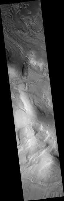
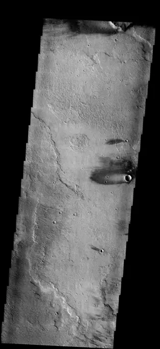
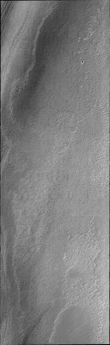
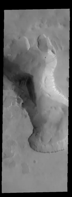
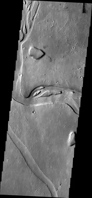
My Boards
View Pictures
  • My Boards

Mars Geological Features

This cluster features various geological formations on Mars, including collapse pits, mantles, flows, and fractures, showcasing the planet's varied surface textures.

Mantles and Flows in Moreux Crater
256 assets in this story
6145-44861967
This image captured by NASA's 2001 Mars Odyssey shows just one of the many lava flows that make up Daedalia Planum. Theses volcanic flows are from Arsia Mons, the southernmost of the three Tharsis Montes.
6145-44557347
Today's VIS image shows the summit of Ascraeus Mons. Ascraeus Mons is the northernmost of the three aligned Tharsis volcanoes. Orbit Number 80602 Latitude 11.189 Longitude 255.887 Instrument VIS Captured 2020-02-15 02 07
6145-44897890
These images from NASA's Dawn spacecraft, located in asteroid Vesta's Oppia quadrangle, in Vesta's northern hemisphere, demonstrate a special analytical technique, which results in shadowed areas of Vesta's surface becoming illuminated.
6145-44814419
This image of Candor Chasma taken by NASA's 2001 Mars Odyssey contains eroded deposits of material and a large landslide deposit. Gravity, wind, and water all played a role in shaping the landforms we see in this image.
6145-44684888
Windstreaks
6145-44666008
Exposure of North Polar Layered Deposits
6145-44644102
This lower resolution image was taken to explore the extent of storm fronts near the south polar region. The cloud cover is thickest in the middle of the frame
6145-44561509
Jupiter's Equatorial Region in Violet Light (Time Set 3)
6145-44868906
This image from NASA's 2001 Mars Odyssey spacecraft shows a fracture north of Argyre Planitia. Note the dunes within the channel.
6145-52930572
Tempe Terra Craters. Today's VIS image shows a portion of Tempe Terra, including two unnamed craters. The ejecta from the smaller crater appears to overlie several graben (linear depressions created by tectonic forces). This means the crater is younger than the graben. However, both craters are slightly oval, in alignment with the graben in the region. Tectonic features may have existed prior to the graben visible today, affecting the formation of the impact crater. Orbit Number 93803 Latitude 40.7678 Longitude 293.279 Instrument VIS Captured 2023-02-06 01 17 https //photojournal.jpl.nasa.gov/catalog/PIA25902
6145-44483276
This VIS image shows a cross section of Pavonis Mons, including the central part of the smaller summit caldera (circular depression). On the top side of the caldera is a complex region of fault related collapse of the wall of the caldera. Several intersecting faults are visible there. The faults would have formed areas of weakness in the caldera wall, precipitating into gravity driven down slope movement of materials. This caldera is approximately 5km (3 miles) deep, much deeper that the larger caldera that surrounds the northern and eastern sides of the small caldera. Pavonis Mons, like the other large volcanoes in the region, is a shield volcano. Shield volcanoes are formed by lava flows originating near or at the summit, building up layers upon layers of lava. In shield volcanoes summit calderas are typically formed where the surface collapses into the void formed by an emptied magma chamber. Pavonis Mons is one of the three aligned Tharsis Volcanoes. In order from north to south ar
6145-44625894
Hebrus Vallis
6145-52961222
. Crater Dunes. This VIS image shows a large sand sheet with surface dune forms as well as smaller sand dunes within an unnamed crater in Noachis Terra. These dunes are composed of basaltic sand that has collected in the bottom of the crater. The topographic depression of the crater forms a sand trap that prevents the sand from escaping. Dune fields are common in the bottoms of craters on Mars and appear as dark splotches that often lean up against the downwind walls of the craters. Dunes are useful for studying both the geology and meteorology of Mars. The sand forms by erosion of larger rocks, but it is unclear when and where this erosion took place on Mars or how such large volumes of sand could be formed. The dunes also indicate the local wind directions by their morphology. Orbit Number 91741 Latitude -49.2207 Longitude 33.9713 Instrument VIS Captured 2022-08-20 05 58
6145-44627231
Tharsis Landslide
6145-44918706
Layer upon layer of volcanic flows make up Daedalia Planum as shown in this image from NASA's 2001 Mars Odyssey spacecraft.
6145-45126520
This mosaic of images includes the most detailed view of the surface of Jupiter's moon Europa obtained by NASA's Galileo mission.
6145-44711630
THEMIS ART #88
6145-45088578
This image from NASA's 2001 Mars Odyssey spacecraft shows a wedge shaped field of dunes located in an unusual depression on the floor of this unnamed crater in Noachis Terra.
6145-44562310
Jupiter's atmospheric circulation is dominated by alternating eastward and westward jets from equatorial to polar latitudes. This image was taken on April 3, 1997, by NASA's Galileo spacecraft.
6145-44922081
The streamlined islands in this image from NASA's 2001 Mars Odyssey spacecraft are located in the channel of Marte Vallis.
6145-44920331
The south polar cap is comprised of many layers of ice, as seen in this image from NASA's 2001 Mars Odyssey spacecraft.
6145-44894428
This image from NASA's 2001 Mars Odyssey spacecraft shows a portion of Hydraotes Chaos. The individual hills on the left side of the image also appear to be layered.
6145-44727683
Hebrus Vallis
6145-45128739
This image captured by NASA's 2001 Mars Odyssey spacecraft shows a field of dunes on the floor of an unnamed crater in Terra Sirenum.
6145-45263043
This image shows Hurricane Lane as viewed by NASA's Multi-angle Imaging SpectroRadiometer (MISR) central, downward-looking camera. These data were captured during Terra orbit 99382.
6145-45128989
This infrared image from NASA's 2001 Mars Odyssey spacecraft covers a large swath of Terra Cimmeria, including numerous craters with dunes and dune fields on their floors.
6145-45263022
This VIS image is located along the edge of the south polar cap. In the upper right corner the non-polar surface is visible. The tightly packed layers to the left are the edge of the polar cap, a very steep cliff-like feature. At the bottom half of the image is a surface where some, but not all, of the polar layers have been eroded away. This surface illustrates how the polar layering forms, filling in the low regions first until all the topography is covered. Orbit Number 74956 Latitude -79.7732 Longitude 100.129 Instrument VIS Captured 2018-11-07 03 11
6145-45114223
This image of the south polar cap captured by NASA's 2001 Mars Odyssey spacecraft shows a surface with hundreds of circular depressions.
6145-44506172
This anaglyph, from NASA's Shuttle Radar Topography Mission, shows the varied topography of eastern New York State and parts of Massachusetts, Connecticut, Pennsylvania and New Jersey. 3D glasses are necessary.
6145-44600895
Cross-Cutting Relationships
6145-44623844
Spirit's View of 'Columbia Hills'
6145-44897922
These images from NASA's Dawn spacecraft, located in asteroid Vesta's Marcia quadrangle, in Vesta's northern hemisphere, demonstrate a special analytical technique, which results in shadowed areas of Vesta's surface becoming illuminated.
6145-44615753
Spirit Heads Toward History
6145-52930527
Ascraeus Mons. This VIS image shows part of the summit of Ascraeus Mons. Ascraeus Mons is the northernmost and tallest of the three large aligned Tharsis volcanoes. Calderas are found at the tops of volcanoes and are the source region for magma that rises from an underground lava source to erupt at the surface. Volcanoes are formed by repeated flows from the central caldera. The final eruptions can pool within the summit caldera, leaving a flat surface as they cool. Calderas are also a location of collapse, creating rings of tectonic faults that form the caldera rim. Ascraeus Mons has several caldera features at its summit. Ascraeus Mons is 18 km (11 miles) tall, for comparison Mauna Kea - the tallest volcano on Earth - is 10 km tall (6.2 miles, measured from the base below sea level). Orbit Number 93767 Latitude 11.2722 Longitude 11.2722 Instrument VIS Captured 2023-02-03 01 58 https //photojournal.jpl.nasa.gov/catalog/PIA25875
6145-44618363
Streaming F Ring
6145-44828069
The dunes in this image captured by NASA's Mars Odyssey are near the north polar cap.
6145-45265898
This VIS image shows layering in the south polar cap. The layers are formed over thousands of years of seasonal change, reflecting ice and dust surface deposition. Where the layers appear close to each other are steep trough sides. The steeper the slope, the closer the layers. Orbit Number 75416 Latitude -86.0108 Longitude 177.703 Instrument VIS Captured 2018-12-15 00 24
6145-44626415
Titan Mosaic: October 2004
6145-44627482
Composite of Titan's Surface Seen During Descent
6145-44665507
North Polar Residual Cap
6145-44859649
Huge gullies, like these captured by NASA's 2001 Mars Odyssey, line both rims of Ius Chasma.
6145-44914028
The sun has now risen over the south pole of Mars. The polar surface is defrosting. This captured by NASA's 2001 Mars Odyssey spacecraft image shows layering near the margin of the south polar cap.
6145-44578629
This image by NASA's Mars Odyssey spacecraft is within a region called Lunae Planum, west of NASA's Viking 1 landing site, that marks the transition between the Tharsis rise, a giant volcanic complex, and the northern lowland plains.
6145-44560502
MOC View of Mars98 Landing Zone - 12/24/97
6145-45263588
Scientists created this stereo view, called an anaglyph, with two images of the same part of Ceres's surface taken by Dawn on different orbits and from different viewing angles. The images were artificially colored and combined so that when viewed through glasses with a red filter on the left and blue on the right, they provide a 3-D view. The images used in this anaglyph were obtained by NASA's Dawn spacecraft from an altitude of about 21 miles (34 kilometers). This feature is located at about 19.5 degrees north latitude and 239.2 degrees east longitude, in the western part of Cerealia Facula.
6145-44997103
The complex fracture in this image captured by NASA's 2001 Mars Odyssey spacecraft is one of the many graben that surround Alba Mons.
6145-44627473
Spirit's Surroundings on 'West Spur,' Sol 305
6145-44639645
This global digital map of Saturn's moon Enceladus was created using data taken during Cassini and Voyager spacecraft flybys. The map is an equidistant projection and has a scale of 110 meters (361 feet) per pixel
6145-44527596
This anaglyph, from NASA's Shuttle Radar Topography Mission, shows the eastern flank of the Andes Mountains, southeast of San Martin de Los Andes, Argentina. 3D glasses are necessary to view this image.
6145-44615777
Riding the Rim of 'Endurance' (polar)
6145-44986745
This image captured by NASA's 2001 Mars Odyssey spacecraft shows another portion of the large dune field near the north polar cap.
6145-52287296
Aerial view of a part of the area affected during the flood disaster of 1953. Note: The description of this photo is not yet complete and will be supplemented on the basis of the data available at a later stage. However, of many photos of the flood disaster 1953, the location is unknown.
6145-44561507
Jupiter's Equatorial Region in the Near-Infrared (Time Set 3)
6145-44546894
These images of the Venus clouds were taken by NASA's Galileo Solid State Imaging System February 13,1990, at a range of about 1 million miles. The smallest detail visible is about 20 miles. They show the state of the clouds near the top of Venus's cloud
6145-44560458
Europa Ice Rafts and similar scales on Earth
6145-52299284
Aerial view of a part of the area affected during the flood disaster of 1953. Note: The description of this photo is not yet complete and will be supplemented on the basis of the data available at a later stage. However, of many photos of the flood disaster 1953, the location is unknown.
PREVIOUS
of 3
NEXT
2401 S. Ervay, Suite 206
Dallas, Texas 75215
United States
Get Started
Free ResearchMy BoardsMy Cart
For Creators
How To License Your ContentContributor PortalFrame of Mind
Resources
API accessPricing
Contact
+1 866 236 0087help@viewpictures.co.uk Contact form
©2026 View Pictures. All Rights Reserved. -A
This site is protected by reCAPTCHA and Google Privacy Policy and Terms of Service apply.