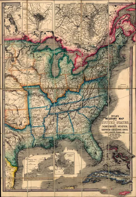
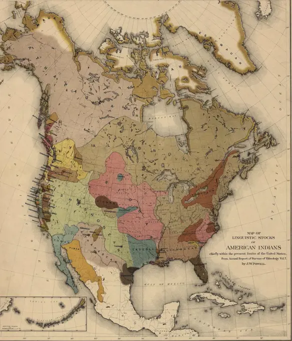
My Boards
View Pictures
  • My Boards

North American Historical Maps

Maps highlighting boundaries and meetings of Friends and Indian tribes, illustrating early American geography and demographics.

Wyld's military map of the United States,  with the forts, harbors, arsenals, and military positions. 1861 USA Civil War
Wyld's military map of the United States, with the forts, harbors, arsenals, and military positions. 1861 USA Civil War
176 assets in this story
6145-51394310
Lloyd's map of the Southern States, showing all the railroads, their stations & distances : also the counties, towns, villages, harbors, rivers, and forts , Railroads, Southern States, Maps, Southern States, Maps Norman B. Leventhal Map Center Collection
6176-66914230
New map of the United States and Mexico. 1847 Pre Mexican - American War
6145-50572776
Pennsylvania , Pennsylvania, Maps Norman B. Leventhal Map Center Collection
4048-5357
1718 French map of North America showing the Mississippi River region, locations of Native American settlements, and the colonies of France, Spain, and Britain.
6145-51395206
Map of the United States, showing by colors the area of freedom and slavery, and the territories whose destiny is yet to be decided : exhibiting also the Missouri compromise line, and the routes of Colonel Fremont in his famous explorations : with important statistics of the free and slave states , Slavery, United States, Maps, Discoveries in geography, American, Maps, United States, Discovery and exploration, Maps, United States, Maps Norman B. Leventhal Map Center Collection
1838-21737461
Geographical, Statistical and Historical Map of Asia, 1820
6145-48656826
Foreign population , Census, United States. Bureau of the Census. Ralph Finos Map Collection
6145-48718576
North America , Indians of North America, Maps, North America, Maps, Great Britain, Territories and possessions, Maps, Russia, Territories and possessions, Maps, United States, Territories and possessions, Maps Norman B. Leventhal Map Center Collection
4443-10977
MAP OF NORTH AMERICA
6145-50568479
Map of Kentucky and Tennessee , Kentucky, Maps, Tennessee, Maps Norman B. Leventhal Map Center Collection
6145-43870753
Foreign population , Census, United States. Bureau of the Census. Ralph Finos Map Collection
4443-10865
MAP OF THE EASTERN PART OF THE UNITED STATES OF AMERICA, 1899
6145-50568867
A map of Louisiana and of the River Mississipi , Mississippi River Valley, Maps, Early works to 1800, North America, Maps, Early works to 1800, Louisiana, Maps, Early works to 1800 Norman B. Leventhal Map Center Collection
6145-51395279
Map showing cotton growing region of the United States and means of transportation by water and rail , Railroads, East U.S., Maps, East U.S., Maps Norman B. Leventhal Map Center Collection
6145-51395284
Map showing Indian reservations within the limits of the United States, 1903 , United States, Maps, Indian reservations, United States, Maps, Indians of North America, Land tenure, Maps Norman B. Leventhal Map Center Collection
6145-55915184
Map showing Indian reservations within the limits of the United States, 1903. Includes 3 insets: Alaska -- Mission Ind. Res. in California -- Indian Territory. Detached from Annual reports of the Department of the Interior, 1903, Indian Affairs (Washington, D.C. : Government Printing Office, 1904). Prime meridians: Washington and Greenwich.... , United States
6145-51396766
Map showing cotton growing region of the United States and means of transportation by water and rail , Railroads, East U.S., Maps, East U.S., Maps Norman B. Leventhal Map Center Collection
6145-50571579
Amplissimae regionis Mississipi seu provinciae Ludovicianae  R.P. Ludovico Hennepin Francisc. Miss. in America septentrionali anno 168 , United States, Maps, Early works to 1800, Louisiana, Maps, Early works to 1800, Mississippi River Valley, Maps, Early works to 1800 Norman B. Leventhal Map Center Collection
6145-48719886
Distribution of the colored population of the United States : 1890 , United States, Population, Maps, United States, Census, 1890, African Americans, Population, Maps Norman B. Leventhal Map Center Collection
6145-48717551
The Graphic map of Bulgaria, eastern Roumelia, the Turkish Empire in Europe, etc., according to the Treaty of Berlin , Balkan Peninsula, Maps Norman B. Leventhal Map Center Collection
6145-29095149
1862 Johnson Map of Kansas, Nebraska and Dakota
6145-54267442
Distribution of the colored population of the United States : 1890. From Statistical atlas of the United States: based upon the results of the eleventh census / by Henry Gannett. Washington : Government Printing Office, 1898. "Plate 10.". America Transformed: The African American population grew from 4.4 million at the beginning of the Civil War to 7.5 million in 1890, representing 12 percent of the country's total population. This map from the statistical atlas using 1890 census data employs six shades of brown to indicate population distribution and density. Most African Americans remained in the Southeast, but many moved to Midwestern and Northeastern states. They established communities in urban areas like St. Louis, Indianapolis, Cincinnati, Philadelphia, New York and Boston... , United States
6145-55957482
The United States of America Cartographic. Atlases, Maps. 1880. Lionel Pincus and Princess Firyal Map Division. Erie County (N.Y.), Real property , New York (State) , Erie County
4048-5308
Map showing the newly independent United States in 1784 following the 1783 Treaty of Paris.  US Territory extended to the Mississippi River, with New Orleans in French control and Florida in Spanish control.
6145-51395282
Map showing Indian reservations within the limits of the United States, 1901 , United States, Maps, Indian reservations, United States, Maps, Indians of North America, Land tenure, Maps Norman B. Leventhal Map Center Collection
6176-66914778
Map of linguistic stocks of American Indians. 1890
6145-55913282
Colton's Florida. Also shows land survey parcels. Includes continuation inset of the southern part. "Entered according to Act of Congress in the year 1868 by G.W. & C.B. Colton ...".. Florida. Florida, Florida
4443-75463833
Map of the southern states illustrating Olney's school geography, published by Robinson, Pratt & Co. between 1837 and 1847. The hand-colored map measures 25 x 42 cm, mounted on a sheet measuring 29 x 46 cm. Speculated to be published in New York
6145-52359212
Diagr. VII ; Free and slave states, 1860 Cartographic. Maps. 1865. Schomburg Center for Research in Black Culture, Manuscripts, Archives and Rare Books Division. Slavery , United States , History
6145-51395285
Map showing Indian reservations within the limits of the United States, 1905 , United States, Maps, Indian reservations, United States, Maps, Indians of North America, Land tenure, Maps Norman B. Leventhal Map Center Collection
6145-29095160
1862 Johnson Map of Maryland and Delaware
1899-20225204
Louisiana and the Gulf, 1730, de LIsle, G.
6145-51396942
Texas and Pacific Rail Way , Texas & Pacific Railway, Counties, Texas, Maps, Railroads, Texas, Maps, Railroads, Oklahoma, Maps, Railroads, United States, Maps, Indians of North America, Oklahoma, Maps, Indian reservations, Oklahoma, Maps, Texas, Maps, Indian Territory, Maps, Oklahoma, Maps Norman B. Leventhal Map Center Collection
4048-5315
Map of linguistic stocks of American Indians by John Wesley Powell.
6145-50552717
Map of North Carolina , North Carolina, Maps Norman B. Leventhal Map Center Collection
6145-29094819
1855 Colton Map of California and San Francisco
6176-66905857
New map of Texas : with the contiguous American & Mexican states 1835
6145-55916027
Phelps & Watson's new map of the United States. Relief shown by hachures. Includes illustrations of state seals, the signing of the Declaration of Independence, signature and profile of signers, and views in the border... New map of the United States. New map of the United States, United States
6145-55181096
Map of the United States Cartographic. Atlases, Maps. 1875. Lionel Pincus and Princess Firyal Map Division. Madison County (N.Y.), Real property , New York (State) , Madison County, Business enterprises , New York (State) , Madison County, United States
6145-55913016
Alden's pictorial map of the United States of North America. Relief shown by hachures. Prime meridian: Washington D.C. Insets: Southern part of Florida -- Northern boundary of Maine -- Map of North America. Includes tables. Views in margins.... , United States
6145-58893161
Roads and Buildings Town of Wareham. Roads and Buildings Town of Wareham
6145-29095172
1862 Johnson Map of Texas
6145-48433812
The Georgia Negro Migration of Negroes. 1890. African American Photographs Assembled for 1900 Paris Exposition.
1899-20225223
Map of Texas 1863, Colton,  G.W.
6176-66906926
A new map of Texas, Oregon, and California : with the regions adjoining by Samuel Augustus Mitchell, 1846
4443-75463208
Map of the United States exhibiting the present status of knowledge relating to the areal distribution of geologic groups (preliminary compilation), 1884. Issued by the U.S. Geological Survey in Washington, D.C., and published by Julius Bien & Co. lith. in New York. The map measures 43 x 70 cm and is in color. It depicts geological information pertaining to the United States
6145-51395191
Map of the United States and territories, showing the possessions and aggressions of the slave power , Slavery, United States, Maps Norman B. Leventhal Map Center Collection
6145-51395128
Map of the town of Dublin, N.H , Real property, New Hampshire, Dublin Town, Maps, Landowners, New Hampshire, Dublin Town, Maps, Dublin N.H. : Town, Maps Norman B. Leventhal Map Center Collection
6145-55181644
Spetsial'naia karta Ukrainy G.de Boplana 1650g. Tekst str.21 A special map of Ukraine by G.de Boplan, 1650. Text p.21 Cartographic. Maps. 1899. General Research Division. Cartography , Russia , History, Russia
6176-66093973
Vintage Map of the State of Texas, 1836 to 1845, by David Hugh Burr, 1833
6145-54276431
American Far West. Photographs of Marshall Plan Programs, Exhibits, and Personnel
6145-48719739
Where the fight will be centered, if there is one , Spanish-American War, 1898, Maps, Southern States, Maps, West Indies, Maps Norman B. Leventhal Map Center Collection
6145-29095225
1863 Johnson Map of Delaware and Maryland
6145-55957545
Map of The United States of America Cartographic. Atlases, Maps. 1873. Lionel Pincus and Princess Firyal Map Division. Steuben County (N.Y.), United States
6145-51395777
National highways map of the United States showing principal transcontinental highways and connecting system of one hundred thousand miles of national highways proposed by the National Highways Association , Roads, United States, Maps Norman B. Leventhal Map Center Collection
6176-67039319
Political map of the Dominion of Canada. Artist: Unknown.
6145-55914676
Bacon's military map of the United States shewing the forts & fortifications. Relief shown by hachures. Prime meridians: Washington and Greenwich. Shows free or non-slavehold states, border slave states, and seeded or confederate states. Includes population and land area figures. "Ent. Sta. Hall. Aug. 1862."... , United States
6145-55913728
Gallup's map of Louisiana. Shows oil fields, gas fields and pipelines on a stratigraphic base map. Includes list of Louisiana refineries. Date of publication taken from date of acquisition... New oil and geological map of Louisiana : showing oil fields, gas fields, pipe lines, refineries and geological formations, etc. New oil and geological map of Louisiana : showing oil fields, gas fields, pipe lines, refineries and geological formations, etc, Louisiana
6239-70845561
The eagle map of the United States  | Library of Congress
6145-48719879
Growth of the Commonwealth (A) , United States, Maps, British Isles, Maps Norman B. Leventhal Map Center Collection
6239-70957839
Illustrated political chart, a cartoon of American politics and the Tapeworm Party | Library of Congress
6145-55915773
Northern Pacific Rail Road and connections. Shows national, state, and provincial boundaries, railroads, cities and towns, drainage, etc. Prime meridians: Washington and Greenwich. Relief shown by hachures. Includes index: Shippers' guide to all points on and contiguous to the Northern Pacific Railroad, its branches and connecting lines.. America Transformed: In 1864, Congress authorized the Northern Pacific Railway Company to construct a northern transcontinental route extending from Minnesota to Washington state. Construction began in 1870, but financial problems hindered progress. Additionally, Native people were aware of the correlation between constructing railroads and the influx of settlers into their homelands and resisted the continued encroachment onto their land. The route was completed in 1883. Rand McNally, a major publisher of railroad maps, printed this map of the main route and tributary routes in the mid-1880s. An alphabetical index identifies the numerous towns and st
6145-50536560
Colton's Texas , Texas, Maps, Galveston Bay Tex., Maps, Sabine Lake La. and Tex., Maps Norman B. Leventhal Map Center Collection
6145-54348230
Maps and Charts - All States. Photographs Relating to National Forests, Resource Management Practices, Personnel, and Cultural and Economic History
4048-5361
2003 map published for the bicentennial commemoration of the Lewis and Clark Expedition. Legend includes preparation, recruitment, exploration and homecoming, Indian reservations, Louisiana Purchase boundary, and Lewis and Clark National Historic Trail.
6145-48433806
The Georgia Negro Relative Negro population of the states of the United States. African American Photographs Assembled for 1900 Paris Exposition.
6145-50524847
United States inlay puzzle , United States, Maps, Jigsaw puzzles, Maps Norman B. Leventhal Map Center Collection
6145-50542672
Florida ,. Robert E. Diefenbach Map Collection
6145-43717187
Canada, United States. Hello! Hello! Everybody on the map! Willimantic is the best thread for sewing machines.. Canada, United States. Hello! Hello! Everybody on the map! Willimantic is the best thread for sewing machines.
6145-51396160
Rambles through our country : an instructive geographical game for the young , Board games, United States, Maps, Educational games, Maps, United States, Maps Norman B. Leventhal Map Center Collection
6145-55916867
Rambles through our country : an instructive geographical game for the young. Pictorial map to be used as a game board. To accompany booklet with same title. Boston Public Library holds map only.. Educational games were a popular way of teaching geography, map reading and history to children in the 19th century. Displayed here is an example from 1890, in which players had to complete a "grand tour" across a colorful and detailed map of the United States. Play began in Hartford, Connecticut, where the game was published, and finished in New York City. There are 200 stops on the tour. Each player spun a numbered wheel in order to advance. At each stop, the player read aloud a description of that location from a corresponding booklet... , United States
6145-54269584
The whole story in a nutshell!. Includes illustrations, text about policies, and captions describing policies for areas of the United States.. Major differences between incumbent Democrat Grover Cleveland and his Republican rival Benjamin Harrison during the 1888 Presidential campaign are emphasized on this campaign poster. During this era of rapid industrialization, Harrison promoted himself as the candidate best suited to national and international concerns while still being aware of important issues at the state level. The map imagery highlights Harrisons expansionist position while underscoring Clevelands limited appeal, particularly in states colored gray. The fact that Harrisons party and administration worked against organized labor did not prevent him from making it a central claim in his campaign poster.. Harrison's ideas! : Republican platform of 1888 Cleveland's ideas! : fruits of "free-wool message," "Mills' bill" and general Democratic policy. Harrison's ideas! : Republica
4443-75465541
State of North Carolina. In Convention, November 23, 1789. Resolution enjoining the representatives of the state in Congress to apply for certain specified amendments to the Constitution of the United States. Signed in manuscript by Sam Johnston, President. Countersigned., 1789, 1 page, 4to
6145-51396996
PWA rebuilds the nation , United States. Public Works Administration, United States, Maps, United States, History, 1933-1945, Maps, Pictorial maps Norman B. Leventhal Map Center Collection
6145-58895957
Ziron 1920 political map. Ziron 1920 political map
6145-51386824
PWA rebuilds the nation , United States. Public Works Administration, United States, Maps, United States, History, 1933-1945, Maps, Pictorial maps Norman B. Leventhal Map Center Collection
PREVIOUS
of 2
NEXT
2401 S. Ervay, Suite 206
Dallas, Texas 75215
United States
Get Started
Free ResearchMy BoardsMy Cart
For Creators
How To License Your ContentContributor PortalFrame of Mind
Resources
API accessPricing
Contact
+1 866 236 0087help@viewpictures.co.uk Contact form
©2026 View Pictures. All Rights Reserved. -B
This site is protected by reCAPTCHA and Google Privacy Policy and Terms of Service apply.